I don't see anything wrong with what Shell Mound said.
Discuss, present data, present counter arguments, but stop the attacks and flippant remarks if you don't like what someone else said.
2018 Indicators: SST's / MSLP / Sal / Steering / Shear / Instability (Graphic updates at first post)
Moderator: S2k Moderators
Forum rules

The posts in this forum are NOT official forecasts and should not be used as such. They are just the opinion of the poster and may or may not be backed by sound meteorological data. They are NOT endorsed by any professional institution or STORM2K. For official information, please refer to products from the National Hurricane Center and National Weather Service.
-
tolakram
- Admin

- Posts: 20186
- Age: 62
- Joined: Sun Aug 27, 2006 8:23 pm
- Location: Florence, KY (name is Mark)
Re: 2018 Indicators: SST's / MSLP / Sal / Steering / Shear / Instability (Graphic updates at first post)
5 likes
M a r k
- - - - -
Join us in chat: Storm2K Chatroom Invite. Android and IOS apps also available.
The posts in this forum are NOT official forecasts and should not be used as such. Posts are NOT endorsed by any professional institution or STORM2K.org. For official information and forecasts, please refer to NHC and NWS products.


-
Sciencerocks
- Category 5

- Posts: 10193
- Age: 40
- Joined: Thu Jul 06, 2017 1:51 am
Re: 2018 Indicators: SST's / MSLP / Sal / Steering / Shear / Instability (Graphic updates at first post)
Most activity is likely to be closer to the United states with that MDR.
Of course 2013 still managed to get 13-14 named storms so maybe my numbers aint wrong but if I am going to bust it may bust too high.
Of course 2013 still managed to get 13-14 named storms so maybe my numbers aint wrong but if I am going to bust it may bust too high.
0 likes
-
Shell Mound
- Category 5
- Posts: 2432
- Age: 33
- Joined: Thu Sep 07, 2017 3:39 pm
- Location: St. Petersburg, FL → Scandinavia
Re: 2018 Indicators: SST's / MSLP / Sal / Steering / Shear / Instability (Graphic updates at first post)
https://twitter.com/philklotzbach/status/999402374018945024
https://twitter.com/wx_tiger/status/998967095286206465
https://twitter.com/wx_tiger/status/998969548576567296
https://twitter.com/wx_tiger/status/998967095286206465
https://twitter.com/wx_tiger/status/998969548576567296
2 likes
CVW / MiamiensisWx / Shell Mound
The posts in this forum are NOT official forecasts and should not be used as such. They are just the opinion of the poster and may or may not be backed by sound meteorological data. They are NOT endorsed by any professional institution or STORM2K. For official information, please refer to products from the NHC and NWS.
-
cycloneye

- Admin
- Posts: 149725
- Age: 69
- Joined: Thu Oct 10, 2002 10:54 am
- Location: San Juan, Puerto Rico
Re: 2018 Indicators: SST's / MSLP / Sal / Steering / Shear / Instability (Graphic updates at first post)
@webberweather
The tropical Atlantic has continued to anomalously cool despite favorable subseasonal forcing w/ an MJO pulse over the Indian Ocean. If an El Nino doesn't form this year, the Atlantic won't be a reason for its demise like it was in 2012 & last year. #ElNino #climate
https://twitter.com/webberweather/status/1001123199990599680
0 likes
Visit the Caribbean-Central America Weather Thread where you can find at first post web cams,radars
and observations from Caribbean basin members Click Here
and observations from Caribbean basin members Click Here
-
NotSparta

- Professional-Met

- Posts: 1677
- Age: 24
- Joined: Fri Aug 18, 2017 8:24 am
- Location: Naples, FL
- Contact:
Re: 2018 Indicators: SST's / MSLP / Sal / Steering / Shear / Instability (Graphic updates at first post)
cycloneye wrote:@webberweather
The tropical Atlantic has continued to anomalously cool despite favorable subseasonal forcing w/ an MJO pulse over the Indian Ocean. If an El Nino doesn't form this year, the Atlantic won't be a reason for its demise like it was in 2012 & last year. #ElNino #climate
[tweet]https://twitter.com/webberweather/status/1001123199990599680[tweet]
I think the resilient +NAO is controlling a lot of that currently
0 likes
This post was probably an opinion of mine, and in no way is official. Please refer to http://www.hurricanes.gov for official tropical analysis and advisories.
My website, with lots of tropical wx graphics, including satellite and recon: http://cyclonicwx.com
My website, with lots of tropical wx graphics, including satellite and recon: http://cyclonicwx.com


Re: 2018 Indicators: SST's / MSLP / Sal / Steering / Shear / Instability (Graphic updates at first post)
The NAO obs have verified higher than forecast. The feedback loop is a lot more prevalent than trusting -NAO net gains long term.
1 likes
The above post and any post by Ntxw is NOT an official forecast and should not be used as such. It is just the opinion of the poster and may or may not be backed by sound meteorological data. It is NOT endorsed by any professional institution including Storm2k. For official information, please refer to NWS products.
Help support Storm2K!
-
wxman57

- Moderator-Pro Met

- Posts: 23175
- Age: 68
- Joined: Sat Jun 21, 2003 8:06 pm
- Location: Houston, TX (southwest)
Re: 2018 Indicators: SST's / MSLP / Sal / Steering / Shear / Instability (Graphic updates at first post)
See if you can spot any difference between May 26, 2017 and May 26, 2018 SSTs in the Atlantic & Pacific:

1 likes

Re: 2018 Indicators: SST's / MSLP / Sal / Steering / Shear / Instability (Graphic updates at first post)
Is interesting to me that on this image the lowest SSTs anomalies west of the 30th longitude are aproximate between the 18th latitude & 26th latitude.
We know that from near Cuban Bahamas & Florida SSTs are cooler than average because of the wet pattern in this area during the past several weeks.

We know that from near Cuban Bahamas & Florida SSTs are cooler than average because of the wet pattern in this area during the past several weeks.
0 likes
-
WeatherEmperor
- S2K Supporter

- Posts: 4806
- Age: 42
- Joined: Thu Sep 04, 2003 2:54 pm
- Location: South Florida
Re: 2018 Indicators: SST's / MSLP / Sal / Steering / Shear / Instability (Graphic updates at first post)
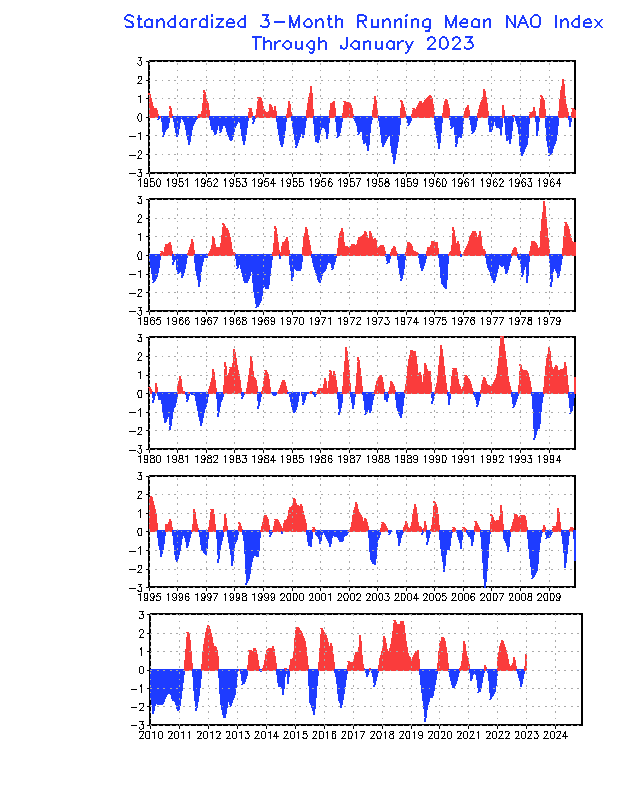
Many have alluded to the positive NAO as being mostly responsible for the cooler than average MDR temps. The NAO is forecast to go negative in the first week of June. Perhaps this could warm up the MDR somewhat?

Sent from my iPhone using Tapatalk
Sent from my iPhone using Tapatalk
2 likes
-
weathaguyry

- Category 5
- Posts: 1273
- Age: 22
- Joined: Wed Jun 15, 2016 5:16 am
- Location: Long Island, NY
Re: 2018 Indicators: SST's / MSLP / Sal / Steering / Shear / Instability (Graphic updates at first post)
Based on previous data,it appears that NAO events tend to only last a few months,so it would make sense for it to flip negative soon
0 likes
My posts are only my opinions and NOT official forecasts. For official forecasts, consult the National Hurricane Center or the National Weather Service.
Irene 11', Sandy 12', Fay 20’, Isaias 20’, Elsa 21’, Henri 21’, Ida 21’
Irene 11', Sandy 12', Fay 20’, Isaias 20’, Elsa 21’, Henri 21’, Ida 21’
-
TheStormExpert
Re: 2018 Indicators: SST's / MSLP / Sal / Steering / Shear / Instability (Graphic updates at first post)
My problem about this season is it could be a little too late for even a sudden flip to a negative NAO pattern to fix the damage done. Yes we could see some rebound in the Tropical Atlantic SST’s but nothing like last season is expected and are even close to materializing with the way things look now.
Last edited by TheStormExpert on Tue May 29, 2018 1:15 pm, edited 1 time in total.
0 likes
-
CyclonicFury

- Category 5
- Posts: 2038
- Age: 27
- Joined: Sun Jul 02, 2017 12:32 pm
- Location: NC
- Contact:
Re: 2018 Indicators: SST's / MSLP / Sal / Steering / Shear / Instability (Graphic updates at first post)
The NAO seems to go negative a lot during the summer months.
0 likes
NCSU B.S. in Meteorology Class of 2021. Tropical weather blogger at http://www.cyclonicfury.com. My forecasts and thoughts are NOT official, for official forecasts please consult the National Hurricane Center.
-
TheStormExpert
Re: 2018 Indicators: SST's / MSLP / Sal / Steering / Shear / Instability (Graphic updates at first post)
In 2004 it was mostly positive 75% of the year and yet the Tropical Atlantic was much warmer than average.
Could this mean that there is something else contributing to the hugely negative SST’s in that subregion?
Could this mean that there is something else contributing to the hugely negative SST’s in that subregion?
0 likes
-
NotSparta
- Professional-Met
- Posts: 1677
- Age: 24
- Joined: Fri Aug 18, 2017 8:24 am
- Location: Naples, FL
- Contact:
Re: 2018 Indicators: SST's / MSLP / Sal / Steering / Shear / Instability (Graphic updates at first post)
TheStormExpert wrote:In 2004 it was mostly positive 75% of the year and yet the Tropical Atlantic was much warmer than average.
Could this mean that there is something else contributing to the hugely negative SST’s in that subregion?
2004 was much less positive, and frequently dipped to neutral or negative. This is a 3 month running mean, so it's very likely there were decent -NAOs then, while the last one of note in 2018 was in March (not including the brief dip to just below neutral in April)
0 likes
This post was probably an opinion of mine, and in no way is official. Please refer to http://www.hurricanes.gov for official tropical analysis and advisories.
My website, with lots of tropical wx graphics, including satellite and recon: http://cyclonicwx.com
My website, with lots of tropical wx graphics, including satellite and recon: http://cyclonicwx.com
-
cycloneye
- Admin
- Posts: 149725
- Age: 69
- Joined: Thu Oct 10, 2002 10:54 am
- Location: San Juan, Puerto Rico
Re: 2018 Indicators: SST's / MSLP / Sal / Steering / Shear / Instability (Graphic updates at first post)
@RyanMaue
Need to investigate upwelling event that has led to dramatic cool water at surface off coast of West Africa ... part of entire Eastern Atlantic over 1°C below last 30-year climatology.
Only 20°C actual SST at 10°N latitude is not very tropical.
https://twitter.com/RyanMaue/status/1001555105387302912
0 likes
Visit the Caribbean-Central America Weather Thread where you can find at first post web cams,radars
and observations from Caribbean basin members Click Here
and observations from Caribbean basin members Click Here
Re: 2018 Indicators: SST's / MSLP / Sal / Steering / Shear / Instability (Graphic updates at first post)
Big difference indeed.
@RyanMaue
If Sea Surface Temperature (SST) is first order predictor of Hurricane Season, then can't find much more of a stark comparison that 2005 vs. 2018. Here are actual SST with water 13 years ago already at 28°C+ in Main Dev Region. (1/2)
https://twitter.com/RyanMaue/status/1001557856167059457
@RyanMaue
If Sea Surface Temperature (SST) is first order predictor of Hurricane Season, then can't find much more of a stark comparison that 2005 vs. 2018. Here are actual SST with water 13 years ago already at 28°C+ in Main Dev Region. (1/2)
https://twitter.com/RyanMaue/status/1001557856167059457
0 likes
-
TheStormExpert
Re: 2018 Indicators: SST's / MSLP / Sal / Steering / Shear / Instability (Graphic updates at first post)
1 likes
-
Emmett_Brown

- Category 5
- Posts: 1433
- Joined: Wed Aug 24, 2005 9:10 pm
- Location: Sarasota FL
Re: 2018 Indicators: SST's / MSLP / Sal / Steering / Shear / Instability (Graphic updates at first post)
NDG wrote:Is interesting to me that on this image the lowest SSTs anomalies west of the 30th longitude are aproximate between the 18th latitude & 26th latitude.
We know that from near Cuban Bahamas & Florida SSTs are cooler than average because of the wet pattern in this area during the past several weeks.
If the pattern of warm anomalies in the north, and normal to below normal MDR SST's holds for prime season, doesn't this type of setup typically create shear and subsidence over the MDR caused by the warm pool to the north? If memory serves, even though MDR SSTs will be plenty warm enough later on, MDR activity can be suppressed.
1 likes
Re: 2018 Indicators: SST's / MSLP / Sal / Steering / Shear / Instability (Graphic updates at first post)
Let's see if the ECMWF is correct but with so much cooler than average SSTs across the Tropical Atlantic it makes sense that July will be very quiet, the dry Sahara will move over the Atlantic, great time to get on a cruise I guess.
@BenNollWeather
As we head into late June and July, there is a relatively strong sub-seasonal signal for upper level convergence across the Atlantic Basin (1) while upper divergence becomes favored over the Pacific (2).
This would favor quiet conditions across the tropical Atlantic during July.
https://twitter.com/BenNollWeather/status/1001782441470607362
1 likes
Who is online
Users browsing this forum: Hurricane2022, Ulf and 202 guests