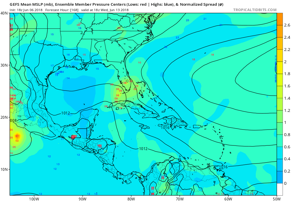
2018 Tropics: Global Model Runs Discussion (Out to day 16)

This is the general tropical discussion area. Anyone can take their shot at predicting a storms path.

Moderator: S2k Moderators

Forum rules

The posts in this forum are NOT official forecasts and should not be used as such. They are just the opinion of the poster and may or may not be backed by sound meteorological data. They are NOT endorsed by any professional institution or STORM2K. For official information, please refer to products from the National Hurricane Center and National Weather Service.

Help Support Storm2K
Message
Author
User avatar
NDG
S2K Supporter
S2K Supporter
Posts: 15446
Joined: Sun Jul 09, 2006 10:14 pm
Location: Orlando, FL

Re: 2018 Tropics: Global Model Runs Discussion (Out to day 16)

#641 Postby NDG » Wed Jun 06, 2018 9:14 pm

Tampa Bay Hurricane wrote:
gatorcane wrote:18Z GFS ensembles, while not particularly enthusiastic, are a good bit to the right of the GFS operational going through or near Southern Florida:

https://s15.postimg.cc/5vts7p8vv/gfs-em ... atl_29.png


Given shear which would cause the center to reform further east a track toward south Florida is a very reasonable solution.

SSTs are a bit higher so the intensity may be ramped up a bit compared to Alberto if other factors are not more inhibitory than they were during Alberto.


Yeap, currently low 80s vs upper 70s just 10 days ago.
0 likes   

LarryWx
S2K Supporter
S2K Supporter
Posts: 6311
Joined: Sun Sep 07, 2003 2:04 pm
Location: GA

Re: 2018 Tropics: Global Model Runs Discussion (Out to day 16)

#642 Postby LarryWx » Wed Jun 06, 2018 9:28 pm

NDG wrote:
LarryWx wrote:
Aric Dunn wrote:
That is 2 more than it did yesterday lol


Point taken.

The EPS remains very quiet although it now has 1 TS in the N GOM 6/14-5 fwiw. So, yes one more than yesterday. But keep in mind that that's only 1 of 50 members.


I'm actually seeing more than one EPS member showing development, but most on the 10-14 day range instead of the 7-10 day range.


I was just talking about the 7-10 day range. I also saw a few lows in the W GOM later in the run but didn't consider those relevant to the potential system being discussed.
0 likes   
Personal Forecast Disclaimer:
The posts in this forum are NOT official forecasts and should not be used as such. They are just the opinion of the poster and may or may not be backed by sound meteorological data. They are NOT endorsed by any professional institution or storm2k.org. For official information, please refer to the NHC and NWS products.

User avatar
NDG
S2K Supporter
S2K Supporter
Posts: 15446
Joined: Sun Jul 09, 2006 10:14 pm
Location: Orlando, FL

Re: 2018 Tropics: Global Model Runs Discussion (Out to day 16)

#643 Postby NDG » Wed Jun 06, 2018 9:42 pm

LarryWx wrote:
NDG wrote:
LarryWx wrote:
Point taken.

The EPS remains very quiet although it now has 1 TS in the N GOM 6/14-5 fwiw. So, yes one more than yesterday. But keep in mind that that's only 1 of 50 members.


I'm actually seeing more than one EPS member showing development, but most on the 10-14 day range instead of the 7-10 day range.


I was just talking about the 7-10 day range. I also saw a few lows in the W GOM later in the run but didn't consider those relevant to the potential system being discussed.


There are few also out of the W Caribbean. The trend has ben one to two more than the previous runs.

Image
1 likes   

User avatar
Hypercane_Kyle
Category 5
Category 5
Posts: 3352
Joined: Sat Mar 07, 2015 7:58 pm
Location: Cape Canaveral, FL

Re: 2018 Tropics: Global Model Runs Discussion (Out to day 16)

#644 Postby Hypercane_Kyle » Wed Jun 06, 2018 10:30 pm

Seems like the usual model dance for western Caribbean development: GFS picks it up first, makes it unreasonably strong, ECMWF shows dada; then the GFS will drop it, the ECMWF will pick it up, and then the GFS picks it up, again. Sanity.
4 likes   
My posts are my own personal opinion, defer to the National Hurricane Center (NHC) and other NOAA products for decision making during hurricane season.

Aric Dunn
Category 5
Category 5
Posts: 21238
Age: 42
Joined: Sun Sep 19, 2004 9:58 pm
Location: Ready for the Chase.
Contact:

Re: 2018 Tropics: Global Model Runs Discussion (Out to day 16)

#645 Postby Aric Dunn » Wed Jun 06, 2018 11:11 pm

00z GFS development starts showing end of june 9th. by the 10th its on the move.
0 likes   
Note: If I make a post that is brief. Please refer back to previous posts for the analysis or reasoning. I do not re-write/qoute what my initial post said each time.
If there is nothing before... then just ask :)

Space & Atmospheric Physicist, Embry-Riddle Aeronautical University,
I believe the sky is falling...

User avatar
NDG
S2K Supporter
S2K Supporter
Posts: 15446
Joined: Sun Jul 09, 2006 10:14 pm
Location: Orlando, FL

Re: 2018 Tropics: Global Model Runs Discussion (Out to day 16)

#646 Postby NDG » Wed Jun 06, 2018 11:17 pm

0z CMC so far tonight.

Image
0 likes   

Aric Dunn
Category 5
Category 5
Posts: 21238
Age: 42
Joined: Sun Sep 19, 2004 9:58 pm
Location: Ready for the Chase.
Contact:

Re: 2018 Tropics: Global Model Runs Discussion (Out to day 16)

#647 Postby Aric Dunn » Wed Jun 06, 2018 11:19 pm

CMC also showing signs around the 10th and 11th..
1 likes   
Note: If I make a post that is brief. Please refer back to previous posts for the analysis or reasoning. I do not re-write/qoute what my initial post said each time.
If there is nothing before... then just ask :)

Space & Atmospheric Physicist, Embry-Riddle Aeronautical University,
I believe the sky is falling...

Aric Dunn
Category 5
Category 5
Posts: 21238
Age: 42
Joined: Sun Sep 19, 2004 9:58 pm
Location: Ready for the Chase.
Contact:

Re: 2018 Tropics: Global Model Runs Discussion (Out to day 16)

#648 Postby Aric Dunn » Wed Jun 06, 2018 11:22 pm

same with 00z ICON.. 10th into 11th.. though not very well defined at the surface.
1 likes   
Note: If I make a post that is brief. Please refer back to previous posts for the analysis or reasoning. I do not re-write/qoute what my initial post said each time.
If there is nothing before... then just ask :)

Space & Atmospheric Physicist, Embry-Riddle Aeronautical University,
I believe the sky is falling...

User avatar
NDG
S2K Supporter
S2K Supporter
Posts: 15446
Joined: Sun Jul 09, 2006 10:14 pm
Location: Orlando, FL

Re: 2018 Tropics: Global Model Runs Discussion (Out to day 16)

#649 Postby NDG » Wed Jun 06, 2018 11:29 pm

According to the GFS we should start seeing convection ramp up across the SW Caribbean as early as this weekend then a vorticity develop by Mon-Tuesday time frame.
1 likes   

User avatar
NDG
S2K Supporter
S2K Supporter
Posts: 15446
Joined: Sun Jul 09, 2006 10:14 pm
Location: Orlando, FL

Re: 2018 Tropics: Global Model Runs Discussion (Out to day 16)

#650 Postby NDG » Wed Jun 06, 2018 11:32 pm

Image
0 likes   

User avatar
Dylan
Professional-Met
Professional-Met
Posts: 338
Age: 30
Joined: Mon May 31, 2010 9:50 am
Location: New Orleans, LA

Re: 2018 Tropics: Global Model Runs Discussion (Out to day 16)

#651 Postby Dylan » Wed Jun 06, 2018 11:32 pm

NDG wrote:According to the GFS we should start seeing convection ramp up across the SW Caribbean as early as this weekend then a vorticity develop by Mon-Tuesday time frame.


Very consistent. Definitely has some merit. Canadian with a similar solution, and the ICON also has a disturbance.
0 likes   
Georges('98), Allison('01), Isidore('02), Lili('02), Frances('04) Ivan('04), Cindy('05), Katrina('05), Rita('05), Gustav('08), Isaac('12), Matthew('16), Harvey('17), Irma('17), Nate ('17), Ida ('21).

Aric Dunn
Category 5
Category 5
Posts: 21238
Age: 42
Joined: Sun Sep 19, 2004 9:58 pm
Location: Ready for the Chase.
Contact:

Re: 2018 Tropics: Global Model Runs Discussion (Out to day 16)

#652 Postby Aric Dunn » Wed Jun 06, 2018 11:34 pm

NDG wrote:According to the GFS we should start seeing convection ramp up across the SW Caribbean as early as this weekend then a vorticity develop by Mon-Tuesday time frame.


yeah the actual convection starts as early as friday with the 850 mb vorticity already in place by saturday into sunday.
by 18z on suday gfs is already 850 mb established and drifting north.
Last edited by Aric Dunn on Wed Jun 06, 2018 11:35 pm, edited 1 time in total.
1 likes   
Note: If I make a post that is brief. Please refer back to previous posts for the analysis or reasoning. I do not re-write/qoute what my initial post said each time.
If there is nothing before... then just ask :)

Space & Atmospheric Physicist, Embry-Riddle Aeronautical University,
I believe the sky is falling...

User avatar
NDG
S2K Supporter
S2K Supporter
Posts: 15446
Joined: Sun Jul 09, 2006 10:14 pm
Location: Orlando, FL

Re: 2018 Tropics: Global Model Runs Discussion (Out to day 16)

#653 Postby NDG » Wed Jun 06, 2018 11:35 pm

Stronger on this run.

Image
2 likes   

User avatar
Steve
S2K Supporter
S2K Supporter
Posts: 9621
Joined: Sat Apr 05, 2003 11:41 pm
Location: Not a state-caster

Re: 2018 Tropics: Global Model Runs Discussion (Out to day 16)

#654 Postby Steve » Wed Jun 06, 2018 11:40 pm

GFS low resolution operational has a 967/968mb system hitting around Grand Bay, AL about at the AL/MS state line in 8.25 days from 00z. If I have that right, that’s next Friday at 1:00am.
0 likes   

User avatar
northjaxpro
S2K Supporter
S2K Supporter
Posts: 8900
Joined: Mon Sep 27, 2010 11:21 am
Location: Jacksonville, FL

Re: 2018 Tropics: Global Model Runs Discussion (Out to day 16)

#655 Postby northjaxpro » Wed Jun 06, 2018 11:41 pm

GFS staying very consistent with a Florida Panhandle or Mobile, AL landfall for June 15 the last several runs counting this 0Z run. Stronger showing potential Beryl as well!
0 likes   
NEVER, EVER SAY NEVER in the tropics and weather in general, and most importantly, with life itself!!

________________________________________________________________________________________

Fay 2008 Beryl 2012 Debby 2012 Colin 2016 Hermine 2016 Julia 2016 Matthew 2016 Irma 2017 Dorian 2019

User avatar
Dylan
Professional-Met
Professional-Met
Posts: 338
Age: 30
Joined: Mon May 31, 2010 9:50 am
Location: New Orleans, LA

Re: 2018 Tropics: Global Model Runs Discussion (Out to day 16)

#656 Postby Dylan » Wed Jun 06, 2018 11:48 pm

NDG wrote:Stronger on this run.

Image


Not moving up in time either. Consistent with a Thursday night landfall. Watch out if the EURO jumps on!
1 likes   
Georges('98), Allison('01), Isidore('02), Lili('02), Frances('04) Ivan('04), Cindy('05), Katrina('05), Rita('05), Gustav('08), Isaac('12), Matthew('16), Harvey('17), Irma('17), Nate ('17), Ida ('21).

User avatar
SouthFloridawx
S2K Supporter
S2K Supporter
Posts: 8346
Age: 46
Joined: Tue Jul 26, 2005 1:16 am
Location: Sarasota, FL
Contact:

Re: 2018 Tropics: Global Model Runs Discussion (Out to day 16)

#657 Postby SouthFloridawx » Wed Jun 06, 2018 11:50 pm

CMC 00Z - 6/16

Image
1 likes   

User avatar
chaser1
S2K Supporter
S2K Supporter
Posts: 5472
Age: 64
Joined: Sat Oct 15, 2005 5:59 pm
Location: Longwood, Fl

Re: 2018 Tropics: Global Model Runs Discussion (Out to day 16)

#658 Postby chaser1 » Thu Jun 07, 2018 12:01 am

Steve wrote:GFS low resolution operational has a 967/968mb system hitting around Grand Bay, AL about at the AL/MS state line in 8.25 days from 00z. If I have that right, that’s next Friday at 1:00am.


The take i'm getting on this, is that this might end up as more of a "rich-mans" Alberto lol. Fully tropical in development, but of course a bit less intense than present GFS wants to indicate and perhaps just over the min. hurricane threshold when all is said and done. Getting to around 150 hours, its hard to imagine the EURO not soon getting on board with this (unless of course, the GFS is entirely out to lunch). I'm plainly seeing the time frame moving closer so am giving the edge to the GFS with regard to genesis and overall general motion.
4 likes   
Andy D

(For official information, please refer to the NHC and NWS products.)

User avatar
chaser1
S2K Supporter
S2K Supporter
Posts: 5472
Age: 64
Joined: Sat Oct 15, 2005 5:59 pm
Location: Longwood, Fl

Re: 2018 Tropics: Global Model Runs Discussion (Out to day 16)

#659 Postby chaser1 » Thu Jun 07, 2018 12:04 am

I probably never did go far back enough in todays posts but, has anyone referenced what the 12Z UK was indicating?
0 likes   
Andy D

(For official information, please refer to the NHC and NWS products.)

User avatar
Siker
Category 4
Category 4
Posts: 904
Age: 28
Joined: Thu Oct 25, 2012 7:36 pm
Location: Miami, FL

Re: 2018 Tropics: Global Model Runs Discussion (Out to day 16)

#660 Postby Siker » Thu Jun 07, 2018 12:17 am

Speaking of the UKMET, anyone have the link to the UKMET text output that updates right at 11:20 central time? Lost it after last season.
0 likes   


Return to “Talkin' Tropics”

Who is online

Users browsing this forum: Google Adsense [Bot], Tx_Summer and 30 guests