ATL: Invest 91L - Discussion
Moderator: S2k Moderators
-
jasons2k

- Storm2k Executive

- Posts: 8290
- Age: 52
- Joined: Wed Jul 06, 2005 12:32 pm
- Location: The Woodlands, TX
Re: ATL: Invest 91L - Discussion
In the end, this will probably be a challenging system to forecast accurately. The models also show a significant rainfall gradient, so it could be a case of feast or famine for parts of Texas and Louisiana.
0 likes
-
Tireman4

- S2K Supporter

- Posts: 5903
- Age: 60
- Joined: Fri Jun 30, 2006 1:08 pm
- Location: Humble, Texas
- Contact:
Re: ATL: Invest 91L - Discussion
Haris wrote:GFS IS SOOOO INCONSISTENT!!! IT LITERALLY SHOWS 10X MORE RAIN FOR TX THIS RUN! SMHHHH
Still very early in the game. Relax. Lol
..it will be more into view by Thursday-Friday
0 likes
-
stormreader
Re: ATL: Invest 91L - Discussion
Tireman4 wrote:Haris wrote:GFS IS SOOOO INCONSISTENT!!! IT LITERALLY SHOWS 10X MORE RAIN FOR TX THIS RUN! SMHHHH
Still very early in the game. Relax. Lol
..it will be more into view by Thursday-Friday
And at this point, I would prefer simply to watch the system itself. What kind of organization (if any) it can attain before crossing the Yucatan. And what it actually looks like over land (ability to hold on to any structure) as it comes off the penninsula. Or perhaps, just a persistent but disorganized system looking for greener pastures in the GOM.
0 likes
-
cycloneye

- Admin
- Posts: 149368
- Age: 69
- Joined: Thu Oct 10, 2002 10:54 am
- Location: San Juan, Puerto Rico
Re: ATL: Invest 91L - Discussion
Tropical Weather Outlook
NWS National Hurricane Center Miami FL
800 PM EDT Tue Jun 12 2018
For the North Atlantic...Caribbean Sea and the Gulf of Mexico:
Disorganized showers and thunderstorms located over the western
Caribbean Sea are associated with a surface trough. This activity
is forecast to move westward to northwestward over Central America
and the Yucatan Peninsula during the next couple of days, with no
development expected. Environmental conditions could become
slightly more conducive for some development if the system moves
into the southwestern Gulf of Mexico by the end of the week.
* Formation chance through 48 hours...low...near 0 percent.
* Formation chance through 5 days...low...20 percent.
$$
Forecaster Avila
0 likes
Visit the Caribbean-Central America Weather Thread where you can find at first post web cams,radars
and observations from Caribbean basin members Click Here
and observations from Caribbean basin members Click Here

Re: ATL: Invest 91L - Discussion
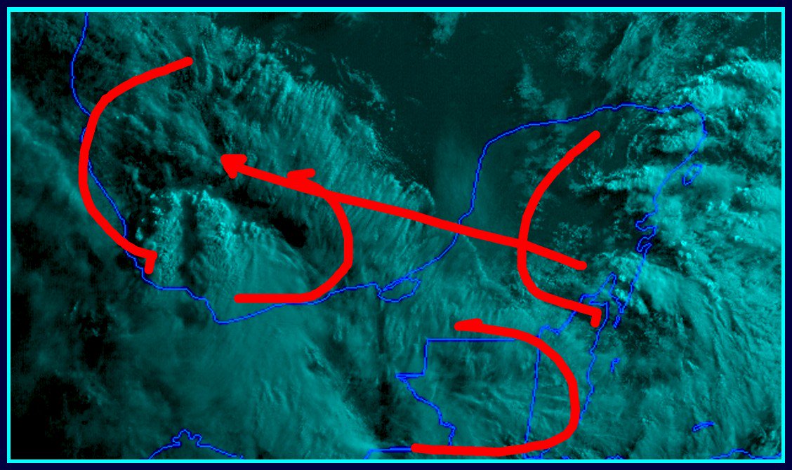
Looking at Vis Satellite, nice blowup at sunset.
Seems like to me just before it got covered with cirrus, along 12N between 82W and 80W, some west winds kicked in.
After that, a couple towers fired off just to the east of that.
Seems like to me just before it got covered with cirrus, along 12N between 82W and 80W, some west winds kicked in.
After that, a couple towers fired off just to the east of that.
0 likes
Re: ATL: Invest 91L - Discussion
Haris wrote:GFS IS SOOOO INCONSISTENT!!! IT LITERALLY SHOWS 10X MORE RAIN FOR TX THIS RUN! SMHHHH
All models are wrong but some models are useful. Focus on the useful parts, not the wrong parts. TX will see significant moisture, there's too much uncertainty to figure out exactly how it will set up this far out.
0 likes
-
Clearcloudz

- Category 2

- Posts: 540
- Joined: Sun Jun 10, 2018 1:46 pm
- Location: Rosenberg TX
Re: ATL: Invest 91L - Discussion
20 Knot wind sheer did its work today and so we start again tomorrow.
Resulted in the NHC dropping to 0 Percent next 48 hours.


Resulted in the NHC dropping to 0 Percent next 48 hours.
0 likes
-
wxman57

- Moderator-Pro Met

- Posts: 23172
- Age: 68
- Joined: Sat Jun 21, 2003 8:06 pm
- Location: Houston, TX (southwest)
Re: ATL: Invest 91L - Discussion
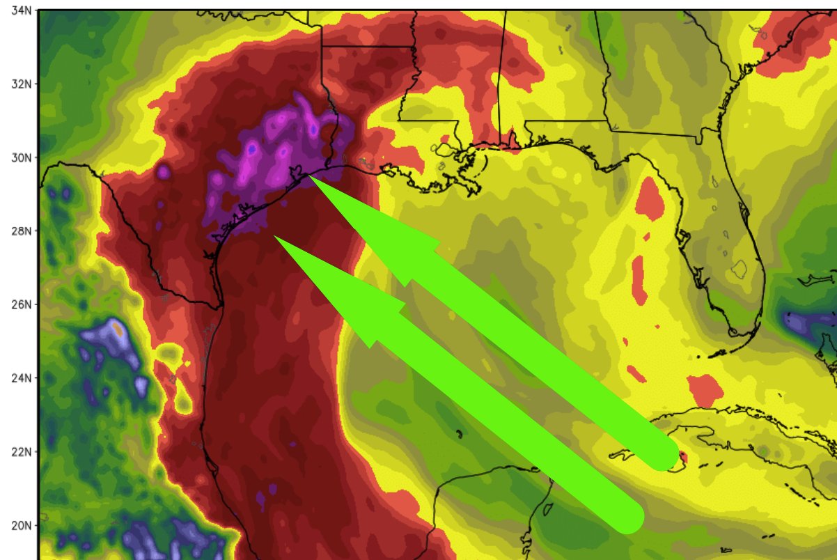
12Z EC ensembles down to only a 10% chance of development. GFS at 14%. Conditions across the Gulf don't look favorable for development (way too much shear). Hopefully, we get a few inches of rain out of it Sun/Mon.
40-50kts of shear = not good for development:

40-50kts of shear = not good for development:
5 likes
-
Tireman4
- S2K Supporter
- Posts: 5903
- Age: 60
- Joined: Fri Jun 30, 2006 1:08 pm
- Location: Humble, Texas
- Contact:
Re: ATL: Invest 91L - Discussion
wxman57 wrote:12Z EC ensembles down to only a 10% chance of development. GFS at 14%. Conditions across the Gulf don't look favorable for development (way too much shear). Hopefully, we get a few inches of rain out of it Sun/Mon.
40-50kts of shear = not good for development:
https://www.tropicaltidbits.com/analysi ... watl_4.png
But if Bud dies out quicker and ....well..lol
0 likes
-
stormreader
Re: ATL: Invest 91L - Discussion
T Storms with the invest appear to be dissipating at this time.
0 likes
-
CyclonicFury

- Category 5

- Posts: 2032
- Age: 27
- Joined: Sun Jul 02, 2017 12:32 pm
- Location: NC
- Contact:
Re: ATL: Invest 91L - Discussion
2 AM TWO remains 0%/20%
000
ABNT20 KNHC 130504
TWOAT
Tropical Weather Outlook
NWS National Hurricane Center Miami FL
200 AM EDT Wed Jun 13 2018
For the North Atlantic...Caribbean Sea and the Gulf of Mexico:
Disorganized showers and thunderstorms over the western Caribbean
Sea are associated with a weak surface trough. This activity is
forecast to move westward to northwestward over Central America and
the Yucatan Peninsula during the next couple of days with no
significant development. Environmental conditions could become
slightly more conducive for some development if the system moves
into the southwestern Gulf of Mexico by the end of the week.
* Formation chance through 48 hours...low...near 0 percent.
* Formation chance through 5 days...low...20 percent.
$$
Forecaster Pasch
0 likes
NCSU B.S. in Meteorology Class of 2021. Tropical weather blogger at http://www.cyclonicfury.com. My forecasts and thoughts are NOT official, for official forecasts please consult the National Hurricane Center.

Re: ATL: Invest 91L - Discussion
Lots of rain. We had late evening storms tonight which is not what’s been happening. GFS has the most rain along the TX Coast. CMC is SW LA. Icon is mostsly offshore and maybe coastal Mississippi.
0 likes
-
Clearcloudz
- Category 2
- Posts: 540
- Joined: Sun Jun 10, 2018 1:46 pm
- Location: Rosenberg TX
Re: ATL: Invest 91L - Discussion
Invest 91L making the transfer into Bay of Campeche
PWATS are gonna be over 2 inches This is abnormally high so heavy rain likely sunday-Wednesday in most of Texas and LA regions. Especially South east Texas as of right now. 12-20 inches is possible and is why needs to be watched closely. Conservative 6 inches will be common for most people.
18Z Nam Model run showing potential Beryl. I do believe the NAM could be overdoing the organization of this system 84 hours out but still something to watch on trends in the short term.
2 likes
-
wxman57
- Moderator-Pro Met
- Posts: 23172
- Age: 68
- Joined: Sat Jun 21, 2003 8:06 pm
- Location: Houston, TX (southwest)
Re: ATL: Invest 91L - Discussion
Western Gulf still look rather hostile toward development. I'm thinking that Beryl will have to wait until August. Just some rain for TX/LA Sunday and Monday from this disturbance.
3 likes
-
northjaxpro

- S2K Supporter
- Posts: 8900
- Joined: Mon Sep 27, 2010 11:21 am
- Location: Jacksonville, FL
Re: ATL: Invest 91L - Discussion
wxman57 wrote:Western Gulf still look rather hostile toward development. I'm thinking that Beryl will have to wait until August. Just some rain for TX/LA Sunday and Monday from this disturbance.
We may not have to wait very long at all for the next disturbance. Latest EURO runs jumping all on potential homebrew off the Florida East Coast by late Sunday into Monday.
3 likes
NEVER, EVER SAY NEVER in the tropics and weather in general, and most importantly, with life itself!!
________________________________________________________________________________________
Fay 2008 Beryl 2012 Debby 2012 Colin 2016 Hermine 2016 Julia 2016 Matthew 2016 Irma 2017 Dorian 2019
________________________________________________________________________________________
Fay 2008 Beryl 2012 Debby 2012 Colin 2016 Hermine 2016 Julia 2016 Matthew 2016 Irma 2017 Dorian 2019
-
Clearcloudz
- Category 2
- Posts: 540
- Joined: Sun Jun 10, 2018 1:46 pm
- Location: Rosenberg TX
Re: ATL: Invest 91L - Discussion
Invest 91L
Deep convection firing up at the tip of the Yucatan.
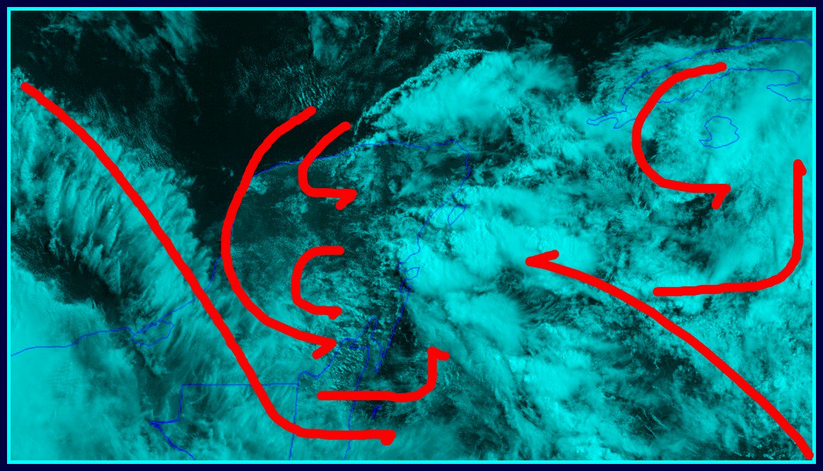

Deep convection firing up at the tip of the Yucatan.
1 likes
-
wxman57
- Moderator-Pro Met
- Posts: 23172
- Age: 68
- Joined: Sat Jun 21, 2003 8:06 pm
- Location: Houston, TX (southwest)
Re: ATL: Invest 91L - Discussion
northjaxpro wrote:wxman57 wrote:Western Gulf still look rather hostile toward development. I'm thinking that Beryl will have to wait until August. Just some rain for TX/LA Sunday and Monday from this disturbance.
We may not have to wait very long at all for the next disturbance. Latest EURO runs jumping all on potential homebrew off the Florida East Coast by late Sunday into Monday.
Yeah, right...
7 likes
Re: ATL: Invest 91L - Discussion
wxman57 wrote:northjaxpro wrote:wxman57 wrote:Western Gulf still look rather hostile toward development. I'm thinking that Beryl will have to wait until August. Just some rain for TX/LA Sunday and Monday from this disturbance.
We may not have to wait very long at all for the next disturbance. Latest EURO runs jumping all on potential homebrew off the Florida East Coast by late Sunday into Monday.
Yeah, right...
You might get some of the 12Z runs in earlier than we can get them. But check out the depictions of the upper pattern over the Southeast in the 5-8 day period. It's not just a phantom idea from the EC if the other models continue to show the strong ridging over the Mid-Atlantic.
1 likes
-
CyclonicFury
- Category 5
- Posts: 2032
- Age: 27
- Joined: Sun Jul 02, 2017 12:32 pm
- Location: NC
- Contact:
Re: ATL: Invest 91L - Discussion
wxman57 wrote:Western Gulf still look rather hostile toward development. I'm thinking that Beryl will have to wait until August. Just some rain for TX/LA Sunday and Monday from this disturbance.
August? It's only June 13. Plenty of time to get Beryl before the end of July. I do think the MDR will probably be dead until August but it's definitely possible we get a weak spinup in the western Atlantic or GOM before then.
3 likes
NCSU B.S. in Meteorology Class of 2021. Tropical weather blogger at http://www.cyclonicfury.com. My forecasts and thoughts are NOT official, for official forecasts please consult the National Hurricane Center.
-
Weather150
- Tropical Storm

- Posts: 190
- Joined: Fri Jul 07, 2017 7:46 pm
Re: ATL: Invest 91L - Discussion
CyclonicFury wrote:wxman57 wrote:Western Gulf still look rather hostile toward development. I'm thinking that Beryl will have to wait until August. Just some rain for TX/LA Sunday and Monday from this disturbance.
August? It's only June 13. Plenty of time to get Beryl before the end of July. I do think the MDR will probably be dead until August but it's definitely possible we get a weak spinup in the western Atlantic or GOM before then.
Agreed, July could offer chances for homegrown spin-ups off the SE coast potentially. Maybe something like a TS Claudette 2015.
2 likes
Who is online
Users browsing this forum: No registered users and 35 guests