Storm Battered wrote:ForexTidbits wrote:
Source?
From
HGX's AFD.
334
FXUS64 KHGX 182032
AFDHGX
Area Forecast Discussion
National Weather Service Houston/Galveston TX
332 PM CDT Mon Jun 18 2018
.DISCUSSION...
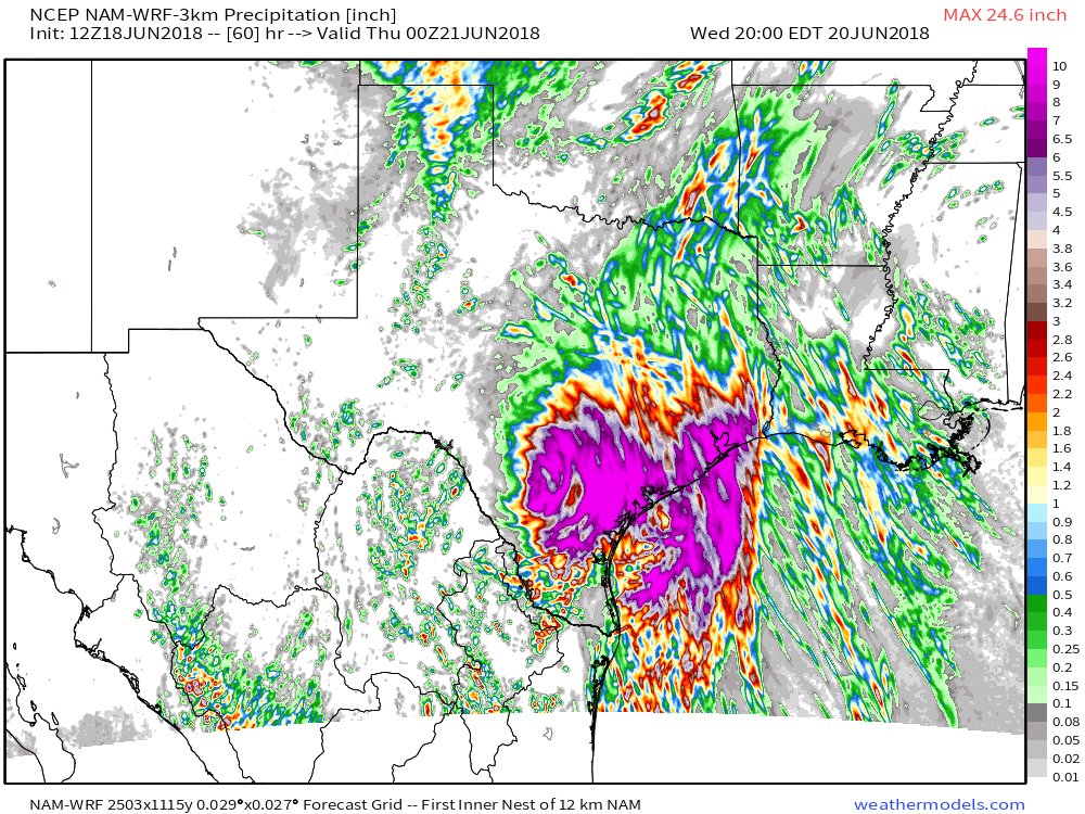
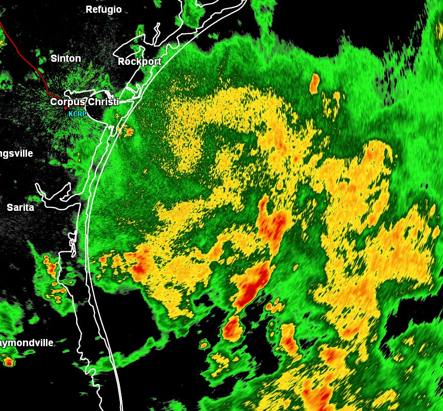
Bands of rain with embedded heavier showers have been moving mainly
to the west and northwest across the area today. So far, locally
heavy rainfall has happened in a very small area (2 to 3 inches
along the Harris/Chambers county line) where some brief training
did set up. Currently, more intense and prolonged training just to
our east in/around the Beaumont area has resulting in a flash
flood warning. The airmass in place supports bands similar to this
one to possibly set up across parts of Southeast Texas over the
next several days as the slow moving Gulf system lingers near the
Texas coast. Models are still having a very very very very very
difficult time indicating where this could possibly happen, with
different locations and amounts evident on nearly every run that
comes out. But conditions still appear favorable for additional
rounds of storms over the next several days in and around our
area, and locally heavy rain will continue to be possible. Through
Thursday, rainfall totals could range from 3 to 5 inches in/around
our northern counties to around 10 inches or even higher closer to
the Matagorda Bay area. If these totals are spread out over time
with rain rates on the low side, the area could handle things
well. However, any intense rainfall in a short period of time
could lead to flooding issues. Based on what has fallen so far
today along with the possibility that rains could be spread out
over several days, highish flash flood guidance values and the
lack of saturated soils, we will not be issuing a Flash Flood
Watch at this time. A watch and/or warnings will be needed if any
banding/training of heavy rainfall does develop. If the rainfall
totals previously mentioned do happen, we`ll likely end up having
some river/bayou/creek issues too. Just because your location has
gotten little to no rainfall yet does not mean you will stay dry
over the next several days. So keep up with the latest forecasts
during this ongoing potentially heavy rain event as things could
rapidly change. 42
&&
.MARINE...
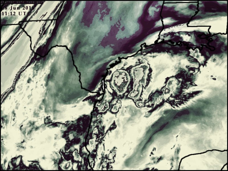
A slow moving, weakly organized tropical wave continues to drift
over the western Gulf of Mexico. This has brought increased winds
and seas as well as widespread showers and thunderstorms to the
region as advertised. The Small Craft Advisory will continue
through the day Tuesday, and has been extended into Wednesday
morning for the offshore waters as seas will by slow to subside.
Tides are expected to remain 1 to 1.5 feet above astronomical levels
today, with high tide at the Galveston Bay Entrance peaking a little
over 3 feet above MLLW at high tide. Given impacts to vulnerable
locations, a coastal flood advisory continues along the Bolivar
Peninsula. Strong rip currents will remain a threat on Gulf facing
beaches for at least another day.
Evans
&&
.PREV DISCUSSION... /ISSUED 1250 PM CDT Mon Jun 18 2018/
AVIATION...
Yet another complicated aviation forecast today with broad
tropical wave and associated moisture feed into sern TX. Models
continue to bring widespread MVFR for all terminals through the
period, however timing and actual location of the more intense
storms/bands difficult to pinpoint. Will keep mostly MVFR
conditions in place, although breaks of VFR will also occur for
most locations, with brief IFR in the intense rain cores.
Evans
&&
.PRELIMINARY POINT TEMPS/POPS...
College Station (CLL) 74 84 74 84 74 / 50 70 40 70 40
Houston (IAH) 76 83 76 83 77 / 80 80 50 60 40
Galveston (GLS) 80 84 81 84 82 / 80 80 60 50 30
&&
.HGX WATCHES/WARNINGS/ADVISORIES...
TX...High Rip Current Risk until 10 PM CDT this evening for the
following zones: Brazoria Islands...Matagorda Islands.
SMALL CRAFT SHOULD EXERCISE CAUTION from Tuesday evening through
Wednesday morning for the following zones: Matagorda
Islands.
Coastal Flood Advisory until 3 PM CDT Tuesday for the following
zones: Galveston Island and Bolivar Peninsula.
GM...SMALL CRAFT SHOULD EXERCISE CAUTION through Wednesday morning
for the following zones: Galveston Bay...Matagorda Bay.
SMALL CRAFT SHOULD EXERCISE CAUTION from Tuesday evening through
Wednesday morning for the following zones: Coastal waters
from Freeport to Matagorda Ship Channel TX out 20 NM...
Coastal waters from High Island to Freeport TX out 20 NM.
Small Craft Advisory until 7 PM CDT Tuesday for the following
zones: Coastal waters from Freeport to Matagorda Ship
Channel TX out 20 NM...Coastal waters from High Island to
Freeport TX out 20 NM.
Small Craft Advisory until 10 AM CDT Wednesday for the following
zones: Waters from Freeport to Matagorda Ship Channel TX
from 20 to 60 NM...Waters from High Island to Freeport TX
from 20 to 60 NM.
&&
$$
Contract Meteorologist. TAMU & MSST. Fiercely authentic, one of a kind. We are all given free will, so choose a life meant to be lived. We are the Masters of our own Stories.
Opinions expressed are mine alone.
Follow me on Twitter at
@1900hurricane : Read blogs at
https://1900hurricane.wordpress.com/