Travis Herzog ABC 13
See full post in link below:
https://www.facebook.com/ABC13TravisHerzog/
9PM TUESDAY UPDATE:
The weather pattern is shifting tonight, and that impact is that we will likely be in the direct path of more rain tomorrow morning when you wake up.
First, my heart goes out to our friends in the Golden Triangle. They too were devastated by Harvey’s flood, and after 6-13” of rain these last two days from Beaumont to Bridge City, we got word today that some homes have again taken on water with numerous streets and summer schools closed now and tomorrow.
Meanwhile in Houston, you can see from this estimated rainfall map that we’ve picked up far less rain in the 1-3” range. The intense training storm band aimed at Beaumont today partially protected us from getting anything worse coming at us from the Gulf.
That rain band has now weakened, which has opened the door for new rain bands to form and blow intense downpours back toward the Texas coastline. It’s looking like we’ll have a wetter morning commute tomorrow in Houston than what we had today. I just hope the rain continues to come down at a manageable rate and we don’t get one of those intense rain bands aimed at us tomorrow. We will be in the direct path of very strong Gulf winds called a “low level jet,” and this will increase the odds that we get more rain than we have in days past.
Texas Summer 2018
Moderator: S2k Moderators
Forum rules

The posts in this forum are NOT official forecast and should not be used as such. They are just the opinion of the poster and may or may not be backed by sound meteorological data. They are NOT endorsed by any professional institution or STORM2K.
-
Clearcloudz

- Category 2

- Posts: 540
- Joined: Sun Jun 10, 2018 1:46 pm
- Location: Rosenberg TX
Re: Texas Summer 2018
0 likes
-
Clearcloudz
- Category 2
- Posts: 540
- Joined: Sun Jun 10, 2018 1:46 pm
- Location: Rosenberg TX
Re: Texas Summer 2018
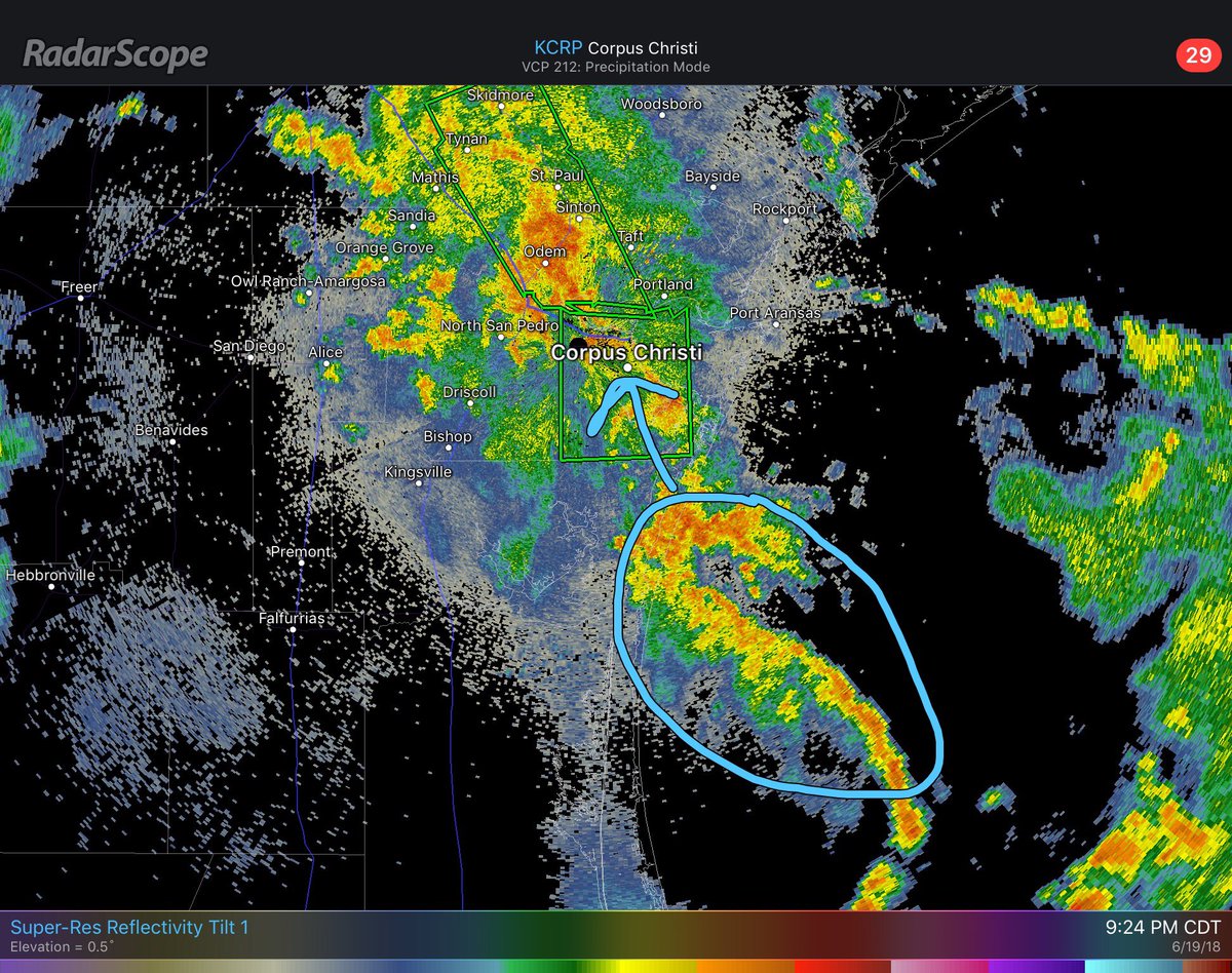
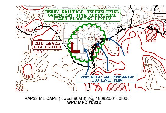
Flash flood event unfolding across metro Corpus Christi this evening with several high water rescues in progress from vehicles. Dangerous flash flooding will be possible as SE low level flow increases on eastern flank of mid level low focusing extended training of intense rains
0 likes
-
Clearcloudz
- Category 2
- Posts: 540
- Joined: Sun Jun 10, 2018 1:46 pm
- Location: Rosenberg TX
Re: Texas Summer 2018
Significant Flash flooding is possible and possible flash flood emergency is being discussed
0 likes
-
Nederlander
- S2K Supporter

- Posts: 1259
- Joined: Sat Jul 19, 2008 4:28 pm
- Location: Conroe, TX
Re: Texas Summer 2018
Cpv17 wrote:I’m not impressed with this system so far. It’s been a dud for me. There’s just not much deep convection associated with it.
Depends on where you’re at bud. I’d be glad to send some your way. I had a five gallon bucket sitting outside and it was overflowing. Many homes in Port Arthur and surrounding areas are flooded again (not finished from Harvey).. sorry you’re not impressed
8 likes
-
jasons2k

- Storm2k Executive

- Posts: 8290
- Age: 52
- Joined: Wed Jul 06, 2005 12:32 pm
- Location: The Woodlands, TX
Re: Texas Summer 2018
Lightning strikes now showing-up offshore SE of Corpus. This is going to get really bad for them.
1 likes
-
Clearcloudz
- Category 2
- Posts: 540
- Joined: Sun Jun 10, 2018 1:46 pm
- Location: Rosenberg TX
Re: Texas Summer 2018
jasons wrote:Lightning strikes now showing-up offshore SE of Corpus. This is going to get really bad for them.
3-4 inches in an hour.

0 likes
-
Clearcloudz
- Category 2
- Posts: 540
- Joined: Sun Jun 10, 2018 1:46 pm
- Location: Rosenberg TX
Re: Texas Summer 2018
Several roads are flooded throughout the city and high water rescues are taking place. One report of motorists stranded on the roof of their vehicles.
1 likes


Re: Texas Summer 2018
Nederlander wrote:Cpv17 wrote:I’m not impressed with this system so far. It’s been a dud for me. There’s just not much deep convection associated with it.
Depends on where you’re at bud. I’d be glad to send some your way. I had a five gallon bucket sitting outside and it was overflowing. Many homes in Port Arthur and surrounding areas are flooded again (not finished from Harvey).. sorry you’re not impressed
That area was never forecasted to see those totals. You guys were on the fringe of the heavier totals with a sharp gradient just to the west. Like I mentioned earlier there are two areas of heavier rain. One in your area and one towards Corpus and the WPC had the heavier totals around Matagorda which is pretty much exactly in between the two areas that are getting it now, so that’s why I’m calling it a bust so far. Just goes to show you once again that the models can get the amount of rain correct (or close to it), but they struggle with placement. Meanwhile, in my area (where the heaviest totals were forecasted) we’ve gotten about 2-3” so far. Nice rain, but I was expecting more. We’ve gotten 3” so far and there isn’t even any water in our ditches which goes to show you how dry it was around here. Hoping to get a couple more inches before it’s all done.
0 likes
-
Clearcloudz
- Category 2
- Posts: 540
- Joined: Sun Jun 10, 2018 1:46 pm
- Location: Rosenberg TX
Re: Texas Summer 2018
20 Unit Streamflow values showing dangerous flash flooding on going in Corpus Christi.

1 likes
-
lrak

- S2K Supporter
- Posts: 1770
- Age: 59
- Joined: Thu Jun 21, 2007 2:48 pm
- Location: Corpus Christi, TX
Re: Texas Summer 2018
It's been nothing like I've seen before. Tropical, sub-tropical what the hect is this thing? It almost looks like a tropical storm making landfall a few days back via visible satellite. Strange!
Corpus hasn't seen this much rain in a while especially the west side. We've always had to rely on morning showers and due to subsidence after the so called "warm front pushed through around 12pm" if no rain then no rain. Death ridge! ACK
Corpus hasn't seen this much rain in a while especially the west side. We've always had to rely on morning showers and due to subsidence after the so called "warm front pushed through around 12pm" if no rain then no rain. Death ridge! ACK
Last edited by lrak on Tue Jun 19, 2018 10:24 pm, edited 1 time in total.
1 likes
AKA karl
Also
Personal Forecast Disclaimer:
My posts on this forum are NOT official forecast and should not be used as such. My posts are my basic observations and are definitely not backed by any "well some" meteorological knowledge. For official information, please refer to the NHC and NWS products.
Also
Personal Forecast Disclaimer:
My posts on this forum are NOT official forecast and should not be used as such. My posts are my basic observations and are definitely not backed by any "well some" meteorological knowledge. For official information, please refer to the NHC and NWS products.
-
bubba hotep

- S2K Supporter
- Posts: 6014
- Joined: Wed Dec 28, 2016 1:00 am
- Location: Collin County Texas
Re: Texas Summer 2018
1-min scans setup for overnight Texas rain event.
http://weather.cod.edu/satrad/exper/?parms=meso-meso1-14-48-0-100-1&checked=map&colorbars=

http://weather.cod.edu/satrad/exper/?parms=meso-meso1-14-48-0-100-1&checked=map&colorbars=
1 likes
Winter time post are almost exclusively focused on the DFW area.
-
lrak
- S2K Supporter
- Posts: 1770
- Age: 59
- Joined: Thu Jun 21, 2007 2:48 pm
- Location: Corpus Christi, TX
Re: Texas Summer 2018
bubba hotep wrote:1-min scans setup for overnight Texas rain event.
http://weather.cod.edu/satrad/exper/?parms=meso-meso1-14-48-0-100-1&checked=map&colorbars=
Man I wish this was the weekend. That looks crazy.
0 likes
AKA karl
Also
Personal Forecast Disclaimer:
My posts on this forum are NOT official forecast and should not be used as such. My posts are my basic observations and are definitely not backed by any "well some" meteorological knowledge. For official information, please refer to the NHC and NWS products.
Also
Personal Forecast Disclaimer:
My posts on this forum are NOT official forecast and should not be used as such. My posts are my basic observations and are definitely not backed by any "well some" meteorological knowledge. For official information, please refer to the NHC and NWS products.
-
lrak
- S2K Supporter
- Posts: 1770
- Age: 59
- Joined: Thu Jun 21, 2007 2:48 pm
- Location: Corpus Christi, TX
Re: Texas Summer 2018
Big BOOM just now. Hope I can sleep 
2 likes
AKA karl
Also
Personal Forecast Disclaimer:
My posts on this forum are NOT official forecast and should not be used as such. My posts are my basic observations and are definitely not backed by any "well some" meteorological knowledge. For official information, please refer to the NHC and NWS products.
Also
Personal Forecast Disclaimer:
My posts on this forum are NOT official forecast and should not be used as such. My posts are my basic observations and are definitely not backed by any "well some" meteorological knowledge. For official information, please refer to the NHC and NWS products.
-
jasons2k
- Storm2k Executive
- Posts: 8290
- Age: 52
- Joined: Wed Jul 06, 2005 12:32 pm
- Location: The Woodlands, TX
Re: Texas Summer 2018
Irak, I hope you are OK down there buddy. It's no fun when it gets past the "of crap, my house could actually flood" part. Really thinking about my friends and relatives to the east and west of me tonight.
OK, regarding those of us in the Houston area,
That eastern band over the Gulf really saved us today. It's terrible for the Golden triangle area (and now Corpus but for other reasons), but it cutoff inflow and kept us in a dry moat of subsidence all day. There are really a few concerns to monitor overnight however:
* The convection out of over the Gulf is gone. It's wide open again for bands to form near the coast and move inland.
* The LLJ may get established over SE Texas tonight, setting-up a training band(s) beneath it.
* As the low/circulation has pivoted a bit to the W/SW today, it will change the orientation of the bands as they move onshore to stretch a little more SE to NW, instead of SSW to NNW. Basically, it will determine training patterns for any bands that setup. This small detail will become very important where any bands intersect the LLJ, as it will draw-out a lot of moisture in isolated locations, potentially like an open fire hydrant.
0 likes

Re: Texas Summer 2018
Nice job by the ECMWF and NAM depicting a low centered over S TX kind of out of nowhere from a few days out. I checked it early today and the 1009 was at the surface. What I think might have happened was that the mid level energy drifted toward the NW Gulf while the surface trough formed a closed low once inland. Probably 6 or 7 different posts pointed out that it didn’t make sense. But there it is. Lots of rain threats still for coastal Texas throughout today. We will have to see if the low spins out, moves off W or SW or if the energy just goes south. Y’all be safe.
1 likes
-
Clearcloudz
- Category 2
- Posts: 540
- Joined: Sun Jun 10, 2018 1:46 pm
- Location: Rosenberg TX
Re: Texas Summer 2018
Travis Herzog ABC 13
See full post in link below:
https://www.facebook.com/ABC13TravisHerzog/
7AM WEDNESDAY UPDATE:
Today it's looking like our turn to get heavier rain than we've had all week. We've been the fortunate ones so far along the Texas Gulf coast. The large stationary band of rain that's been aimed at Beaumont the past two days helped shield us from all the flooding rains observed in the Golden Triangle and Corpus Christi.
That band is now gone, which means the Gulf is open for business today.
We're still in good shape as of this writing, but another Flash Flood Watch is in effect until 7PM for part of our region.
Everything I'm seeing today points toward numerous slow-moving, heavy storms possible for our region off-and-on thru Thursday morning. These will dump a quick 1-2" in most spots, but isolated regions could pick up 4-6". If those higher accumulations fall over any of our creeks or bayous, they'll fill up quickly with water like South Mayde Creek did yesterday when nearly 5" fell on the west side of Houston.
Again, if we can make it to Thursday afternoon with no major issues, then we can breathe a collective sigh of relief. That's when the drier air will arrive and push out the tropical moisture.
0 likes
-
Portastorm

- Storm2k Moderator

- Posts: 9955
- Age: 63
- Joined: Fri Jul 11, 2003 9:16 am
- Location: Round Rock, TX
- Contact:
Re: Texas Summer 2018
Poor Corpus ... looks like y'all are getting pounded again with heavy rain. Hope Irak and cctxhurricanewatcher are doing alright. Thinking of you guys.
1 likes
Any forecasts under my name are to be taken with a grain of salt. Get your best forecasts from the National Weather Service and National Hurricane Center.
-
lrak
- S2K Supporter
- Posts: 1770
- Age: 59
- Joined: Thu Jun 21, 2007 2:48 pm
- Location: Corpus Christi, TX
Re: Texas Summer 2018
Thanks everyone for the concern we seem to be handling most of it since it's been consistent "medium I guess" in the amount coming down which allows for decent run off into the creeks and ditches. I sure hope it continues that way.
0 likes
AKA karl
Also
Personal Forecast Disclaimer:
My posts on this forum are NOT official forecast and should not be used as such. My posts are my basic observations and are definitely not backed by any "well some" meteorological knowledge. For official information, please refer to the NHC and NWS products.
Also
Personal Forecast Disclaimer:
My posts on this forum are NOT official forecast and should not be used as such. My posts are my basic observations and are definitely not backed by any "well some" meteorological knowledge. For official information, please refer to the NHC and NWS products.
-
srainhoutx

- S2K Supporter
- Posts: 6919
- Age: 68
- Joined: Sun Jan 14, 2007 11:34 am
- Location: Haywood County, NC
- Contact:
Re: Texas Summer 2018
McAllen to Harlingen has been hit very hard in S Texas. Water rescues from homes underway in Weslaco which has been hit particularly hard.
0 likes
Carla/Alicia/Jerry(In The Eye)/Michelle/Charley/Ivan/Dennis/Katrina/Rita/Wilma/Ike/Harvey
Member: National Weather Association
Wx Infinity Forums
http://wxinfinity.com/index.php
Facebook.com/WeatherInfinity
Twitter @WeatherInfinity
Member: National Weather Association
Wx Infinity Forums
http://wxinfinity.com/index.php
Facebook.com/WeatherInfinity
Twitter @WeatherInfinity
-
lrak
- S2K Supporter
- Posts: 1770
- Age: 59
- Joined: Thu Jun 21, 2007 2:48 pm
- Location: Corpus Christi, TX
Re: Texas Summer 2018
Wow didn't know that and I should of kept my mouth shut because it is really coming down now.
0 likes
AKA karl
Also
Personal Forecast Disclaimer:
My posts on this forum are NOT official forecast and should not be used as such. My posts are my basic observations and are definitely not backed by any "well some" meteorological knowledge. For official information, please refer to the NHC and NWS products.
Also
Personal Forecast Disclaimer:
My posts on this forum are NOT official forecast and should not be used as such. My posts are my basic observations and are definitely not backed by any "well some" meteorological knowledge. For official information, please refer to the NHC and NWS products.
Return to “USA & Caribbean Weather”
Who is online
Users browsing this forum: Cpv17 and 67 guests