WPAC: MARIA - Post-Tropical

Moderator: S2k Moderators

Message
Author
User avatar
cycloneye
Admin
Admin
Posts: 145294
Age: 68
Joined: Thu Oct 10, 2002 10:54 am
Location: San Juan, Puerto Rico

Re: WPAC: MARIA - Tropical Storm: JTWC 21:00 UTC Warning at 55 kts

#141 Postby cycloneye » Wed Jul 04, 2018 4:10 pm

Prognostic reasoning of 21:00 UTC warning by JTWC came out very delayed so here it is.

WDPN32 PGTW 042100
MSGID/GENADMIN/JOINT TYPHOON WRNCEN PEARL HARBOR HI//
SUBJ/PROGNOSTIC REASONING FOR TROPICAL STORM 10W (MARIA) WARNING
NR 09//
RMKS//
1. FOR METEOROLOGISTS.
2. 6 HOUR SUMMARY AND ANALYSIS.
TROPICAL STORM (TS) 10W (MARIA), LOCATED APPROXIMATELY 6 NM SOUTH
OF ANDERSEN AFB, HAS TRACKED NORTH-NORTHWESTWARD AT 09 KNOTS OVER
THE PAST SIX HOURS. ANIMATED ENHANCED INFRARED SATELLITE IMAGERY
DEPICTS A RAPIDLY CONSOLIDATING SYSTEM WITH AN OBLONG CENTRAL DENSE
OVERCAST FEATURE OBSCURING THE LOW-LEVEL CIRCULATION CENTER (LLCC).
HOWEVER, RECENT RADAR IMAGERY (LAST IMAGE RECEIVED AT 1728Z DUE TO
AN UNKNOWN OUTAGE AT THE RADAR SITE) FROM ANDERSEN AFB DEPICTED
TIGHTLY-CURVED BANDING WRAPPING INTO A WELL-DEFINED LLCC LOCATED
ABOUT 8NM TO THE SOUTHEAST OF ANDERSEN AFB. A 041808Z SSMIS 91GHZ
IMAGE REVEALS DEEP CONVECTIVE BANDING WRAPPING INTO A COMPACT CORE
WITH INTENSE DEEP CONVECTION OVER THE NORTH AND WEST QUADRANTS,
WHICH CORRESPONDS WELL TO THE AREA OF MAXIMUM WINDS OBSERVED IN THE
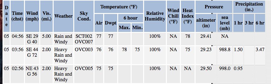
BASE VELOCITY PRODUCT. SURFACE OBSERVATIONS FROM ANDERSEN AFB SHOWED
THAT THE LLCC TRACKED JUST TO THE SOUTH OF THE BASE AND PRODUCED
MAXIMUM SUSTAINED WINDS AS HIGH AS 50 KNOTS WITH GUSTS AS HIGH AS 83
KNOTS--THESE WINDS HAVE QUICKLY ABATED AND NOW RANGE FROM 30 TO 35
KNOTS SUSTAINED. MINIMUM SLP WAS REPORTED AT 984MB, WHICH
CORRESPONDS TO A 50 TO 55 KNOT INTENSITY. THEREFORE, THE CURRENT
INTENSITY IS ASSESSED AT 55 KNOTS, HEDGED HIGHER THAN THE KNES/PGTW
DVORAK ESTIMATES OF T3.0 (45 KNOTS). OBJECTIVE DVORAK ESTIMATES
RANGE FROM 50 TO 55 KNOTS. UPPER-LEVEL ANALYSIS INDICATES A
FAVORABLE ENVIRONMENT WITH ROBUST POLEWARD OUTFLOW ENHANCED BY TUTT
CELLS NEAR 20N 160E AND 15N 135E. ADDITIONALLY, VERTICAL WIND SHEAR
(VWS) IS LOW, SST VALUES RANGE FROM 29 TO 30C AND OCEAN HEAT CONTENT
VALUES ARE VERY HIGH. TS 10W IS CURRENTLY LOCATED ALONG THE WESTERN
PERIPHERY OF A WEAK NORTH-SOUTH ORIENTED STEERING RIDGE WITH A
STRONG EAST-WEST ORIENTED SUBTROPICAL RIDGE (STR) ENTRENCHED TO THE
NORTH, THEREFORE, THE SYSTEM IS TRACKING NORTH-NORTHWESTWARD TO
NORTHWESTWARD.
3. FORECAST REASONING.
A. THE SYSTEM IS NOW FORECAST TO RAPIDLY INTENSIFY OVER THE NEXT
TWO TO THREE DAYS TO A PEAK INTENSITY OF 135 KNOTS BY TAU 72.
B. TS 10W IS FORECAST TO CONTINUE TRACKING NORTH-NORTHWESTWARD TO
NORTHWESTWARD THROUGH TAU 72. NUMERICAL MODEL GUIDANCE IS IN FAIR
AGREEMENT WITH A 170NM SPREAD IN SOLUTIONS AT TAU 72. THE SYSTEM IS
FORECAST TO RAPIDLY INTENSIFY THROUGH TAU 72 WITH A PEAK INTENSITY
OF 135 KNOTS AT TAU 72 DUE TO VERY FAVORABLE ENVIRONMENTAL
CONDITIONS.
C. AFTER TAU 72, TS 10W IS FORECAST TO TURN INCREASINGLY WEST-
NORTHWESTWARD AS THE EAST-WEST ORIENTED STR BECOMES THE DOMINANT
STEERING INFLUENCE. ENVIRONMENTAL CONDITIONS ARE FORECAST TO DEGRADE
AS SST COOLS SLIGHTLY, OCEAN HEAT CONTENT VALUES DECREASE AND UPPER-
LEVEL DIVERGENCE WEAKENS DUE TO INCREASING NORTHERLY VWS ASSOCIATED
WITH A BUILDING UPPER-LEVEL RIDGE TO THE NORTH AND NORTHWEST.
CONFIDENCE IN THE JTWC FORECAST TRACK REMAINS LOW DUE TO A FAIRLY
LARGE SPREAD OF 255NM IN SOLUTIONS AT TAU 120. THIS INCREASING
UNCERTAINTY BETWEEN THE MODELS IS LARGELY ATTRIBUTED TO SIGNIFICANT
DIFFERENCES IN THE STRENGTH OF THE STR.//
NNNN
0 likes   
Visit the Caribbean-Central America Weather Thread where you can find at first post web cams,radars
and observations from Caribbean basin members Click Here

euro6208

Re: WPAC: MARIA - Tropical Storm: JTWC 21:00 UTC Warning at 55 kts

#142 Postby euro6208 » Wed Jul 04, 2018 4:18 pm

Image

Sunrise over Maria.
0 likes   

euro6208

Re: WPAC: MARIA - Tropical Storm

#143 Postby euro6208 » Wed Jul 04, 2018 5:01 pm

000
WTPQ32 PGUM 042130
TCPPQ2

BULLETIN
TROPICAL STORM MARIA (10W) Advisory Number 9
National Weather Service Tiyan GU WP102018
730 AM ChST Thu Jul 5 2018

...TROPICAL STORM MARIA STRENGTHENING NORTH OF GUAM...

Changes with this advisory
--------------------------
A Tropical Storm Warning is now in effect for Tinian, Saipan and
adjacent coastal waters.

Watches and warnings
--------------------
A tropical storm warning is now in effect for Tinian, Saipan and
adjacent coastal waters. Tropical storm conditions, including
damaging winds of 39 mph or more, are expected later today.

A tropical storm warning remains in effect for Guam, Rota and
adjacent waters. Tropical storm conditions, including damaging winds
of 39 mph or more, are occurring this morning.

Summary of 700 AM CHST...2100 UTC...Information
----------------------------------------------
Location...13.9N 144.7E

About 30 miles north of Guam
About 35 miles west-southwest of Rota
About 95 miles southwest of Tinian
About 110 miles southwest of Saipan
About 345 miles south-southwest of Agrihan

Maximum sustained winds...65 mph
Present movement...north-northwest...330 degrees at 10 mph

Discussion and outlook
----------------------
At 700 AM CHST...2100 UTC...the center of Tropical Storm Maria was
located near Latitude 13.9 North and Longitude 144.7 East. Tropical
Storm Maria is moving toward the north-northwest at 10 mph. It is
expected to make a slight turn toward the northwest with a slight
decrease in forward speed over the next 24 hours.

Maximum sustained winds remain at 65 mph. Tropical Storm Maria is
forecast to intensify over the next few days, possibly becoming a
typhoon tonight or early Friday.

Tropical Storm force winds extend outward up to 90 miles north of
the center and up to 80 miles south of the center.

Next advisory
-------------
An intermediate advisory will be issued by the National Weather
Service at 1100 AM this morning followed by the next scheduled
advisory at 200 PM this afternoon.

$$

Kleeschulte
1 likes   

User avatar
cycloneye
Admin
Admin
Posts: 145294
Age: 68
Joined: Thu Oct 10, 2002 10:54 am
Location: San Juan, Puerto Rico

Re: WPAC: MARIA - Tropical Storm

#144 Postby cycloneye » Wed Jul 04, 2018 5:40 pm

Wow,18z GFS down to 901 mbs.

Image
0 likes   
Visit the Caribbean-Central America Weather Thread where you can find at first post web cams,radars
and observations from Caribbean basin members Click Here

Alyono
Professional-Met
Professional-Met
Posts: 6961
Joined: Fri Apr 26, 2013 3:52 pm
Location: Texas Coast

Re: WPAC: MARIA - Tropical Storm

#145 Postby Alyono » Wed Jul 04, 2018 5:45 pm

83 kt gusts should be a typhoon
2 likes   

User avatar
1900hurricane
Category 5
Category 5
Posts: 6059
Age: 34
Joined: Fri Feb 06, 2015 12:04 pm
Location: Houston, TX
Contact:

Re: WPAC: MARIA - Tropical Storm

#146 Postby 1900hurricane » Wed Jul 04, 2018 6:04 pm

Looks like the intensification rate may have slowed down a little as it goes for a slightly larger core.

Image

Image

Image
3 likes   
Contract Meteorologist. TAMU & MSST. Fiercely authentic, one of a kind. We are all given free will, so choose a life meant to be lived. We are the Masters of our own Stories.
Opinions expressed are mine alone.

Follow me on Twitter at @1900hurricane : Read blogs at https://1900hurricane.wordpress.com/

User avatar
StruThiO
Category 3
Category 3
Posts: 821
Age: 25
Joined: Fri Sep 15, 2017 5:51 am
Location: Currently Portland, OR. Raised in Jax, FL.

Re: WPAC: MARIA - Tropical Storm

#147 Postby StruThiO » Wed Jul 04, 2018 6:21 pm

Having fun, Euro? :D

Gorgeous storm, but Super Typhoon Maria sounds out of place after last year.
0 likes   

euro6208

Re: WPAC: MARIA - Tropical Storm

#148 Postby euro6208 » Wed Jul 04, 2018 6:27 pm

StruThiO wrote:Having fun, Euro? :D

Gorgeous storm, but Super Typhoon Maria sounds out of place after last year.


Nope. Rain and winds making me lazy today. I just want to go to sleep. Good thing i'm off today. Besides some fallen trees, this is more than a passing thunderstorm for us. :lol:
1 likes   

User avatar
1900hurricane
Category 5
Category 5
Posts: 6059
Age: 34
Joined: Fri Feb 06, 2015 12:04 pm
Location: Houston, TX
Contact:

Re: WPAC: MARIA - Tropical Storm

#149 Postby 1900hurricane » Wed Jul 04, 2018 6:32 pm

Alyono wrote:83 kt gusts should be a typhoon

I ran KZC based off of discussion and b-deck data to solve for winds (I solved for 1 minute sustained and 3 second gust winds), and I've more or less come to the same conclusion.

Using a 984 mb central pressure, 9 kt forward speed,
72 nm average TS radius, and 13.6º latitude, KZC outputs
a 65 kt 1 min wind velocity with an OCI of 1005 mb.

Using a 984 mb central pressure, 9 kt forward speed,
72 nm average TS radius, and 13.6º latitude, KZC outputs
a 80 kt 3 sec wind velocity with an OCI of 1005 mb.


The 80 kt gust speed in my solution matches up rather well with the recorded 83 kt gust.

I also solved using the radius of the outermost closed isobar and ended up within a knot of my previous estimate.

>>> from TCeq import KZC, KZCroci
>>> p = 984
>>> oci = 1005
>>> roci = 175
>>> c = 9
>>> l = 13.6
>>> v = 50
>>> p0 = 1000
>>> while p0 > p:
v = v + 0.1
p0 = KZC(KZCroci(v, c, roci, l), oci)


>>> v
64.40000000000018
Last edited by 1900hurricane on Wed Jul 04, 2018 6:51 pm, edited 1 time in total.
3 likes   
Contract Meteorologist. TAMU & MSST. Fiercely authentic, one of a kind. We are all given free will, so choose a life meant to be lived. We are the Masters of our own Stories.
Opinions expressed are mine alone.

Follow me on Twitter at @1900hurricane : Read blogs at https://1900hurricane.wordpress.com/

euro6208

Re: WPAC: MARIA - Tropical Storm

#150 Postby euro6208 » Wed Jul 04, 2018 6:35 pm

How about 901 mb GFS? NAVGEM has similiar track to GFS into the Koreas while JMA with EURO. CMC is the northern outliers brings it to Mainland Japan.

Image
Image

EURO...Shanghai?

Image
Image
0 likes   

User avatar
Kingarabian
S2K Supporter
S2K Supporter
Posts: 15980
Joined: Sat Aug 08, 2009 3:06 am
Location: Honolulu, Hawaii

Re: WPAC: MARIA - Tropical Storm

#151 Postby Kingarabian » Wed Jul 04, 2018 6:38 pm

JTWC will probably wait for an ASCAT pass first.
2 likes   
RIP Kobe Bryant

User avatar
cycloneye
Admin
Admin
Posts: 145294
Age: 68
Joined: Thu Oct 10, 2002 10:54 am
Location: San Juan, Puerto Rico

Re: WPAC: MARIA - Tropical Storm

#152 Postby cycloneye » Wed Jul 04, 2018 8:16 pm

00z Best Track up to 60 kts.

Location: 14.1°N 144.1°E
Maximum Winds: 60 kt
Minimum Central Pressure: 978 mb
0 likes   
Visit the Caribbean-Central America Weather Thread where you can find at first post web cams,radars
and observations from Caribbean basin members Click Here

User avatar
cycloneye
Admin
Admin
Posts: 145294
Age: 68
Joined: Thu Oct 10, 2002 10:54 am
Location: San Juan, Puerto Rico

Re: WPAC: MARIA - Tropical Storm

#153 Postby cycloneye » Wed Jul 04, 2018 8:41 pm

JMA 00:50 UTC warning:

TS 1808 (Maria)
Issued at 00:50 UTC, 5 July 2018

<Analysis at 00 UTC, 5 July>
Scale -
Intensity -
Center position N14°10' (14.2°)
E143°55' (143.9°)
Direction and speed of movement NW 15 km/h (9 kt)
Central pressure 994 hPa
Maximum wind speed near center 23 m/s (45 kt)
Maximum wind gust speed 35 m/s (65 kt)
≥ 30 kt wind area NE 220 km (120 NM)
SW 170 km (90 NM)

<Forecast for 00 UTC, 6 July>
Intensity -
Center position of probability circle N16°20' (16.3°)
E142°20' (142.3°)
Direction and speed of movement NW 15 km/h (7 kt)
Central pressure 985 hPa
Maximum wind speed near center 30 m/s (60 kt)
Maximum wind gust speed 45 m/s (85 kt)
Radius of probability circle 90 km (50 NM)
Storm warning area ALL 150 km (80 NM)

<Forecast for 00 UTC, 7 July>
Intensity Strong
Center position of probability circle N18°00' (18.0°)
E141°25' (141.4°)
Direction and speed of movement NNW Slow
Central pressure 960 hPa
Maximum wind speed near center 40 m/s (80 kt)
Maximum wind gust speed 60 m/s (115 kt)
Radius of probability circle 180 km (95 NM)
Storm warning area ALL 280 km (150 NM)

<Forecast for 00 UTC, 8 July>
Intensity Very strong
Center position of probability circle N20°30' (20.5°)
E139°20' (139.3°)
Direction and speed of movement NW 15 km/h (8 kt)
Central pressure 950 hPa
Maximum wind speed near center 45 m/s (90 kt)
Maximum wind gust speed 65 m/s (130 kt)
Radius of probability circle 240 km (130 NM)
Storm warning area ALL 370 km (200 NM)

<Forecast for 00 UTC, 9 July>
Center position of probability circle N22°40' (22.7°)
E135°10' (135.2°)
Direction and speed of movement WNW 20 km/h (11 kt)
Radius of probability circle 370 km (200 NM)

<Forecast for 00 UTC, 10 July>
Center position of probability circle N25°30' (25.5°)
E130°05' (130.1°)
Direction and speed of movement WNW 25 km/h (14 kt)
Radius of probability circle 540 km (290 NM)


Image
0 likes   
Visit the Caribbean-Central America Weather Thread where you can find at first post web cams,radars
and observations from Caribbean basin members Click Here

CrazyC83
Professional-Met
Professional-Met
Posts: 34002
Joined: Tue Mar 07, 2006 11:57 pm
Location: Deep South, for the first time!

Re: WPAC: MARIA - Tropical Storm

#154 Postby CrazyC83 » Wed Jul 04, 2018 8:52 pm

cycloneye wrote:@ExtremeStorms
Pressure drop at Andersen AFB almost 10mb in 1 hr. as Maria came through.


Image

 https://twitter.com/ExtremeStorms/status/1014590028524158976


That 984mb pressure was probably accurate...at that time I would have estimated the intensity at about 65 kt given the data and very high gusts.
0 likes   

Alyono
Professional-Met
Professional-Met
Posts: 6961
Joined: Fri Apr 26, 2013 3:52 pm
Location: Texas Coast

Re: WPAC: MARIA - Tropical Storm

#155 Postby Alyono » Wed Jul 04, 2018 8:53 pm

This did not form from a monsoon trough, so the WPAC P/W is not likely valid. Atlantic P/W probably works best here
2 likes   

CrazyC83
Professional-Met
Professional-Met
Posts: 34002
Joined: Tue Mar 07, 2006 11:57 pm
Location: Deep South, for the first time!

Re: WPAC: MARIA - Tropical Storm: JTWC 21:00 UTC Warning at 55 kts

#156 Postby CrazyC83 » Wed Jul 04, 2018 8:55 pm

CyclonicFury wrote:Ironically, if Maria becomes a Category 5 on the SSHWS, it would be the first NHEM C5 since Maria.


Why didn't they get rid of the name once and for all after it was retired in the Atlantic? Now you get comparisons and confusion.
0 likes   

Alyono
Professional-Met
Professional-Met
Posts: 6961
Joined: Fri Apr 26, 2013 3:52 pm
Location: Texas Coast

Re: WPAC: MARIA - Tropical Storm

#157 Postby Alyono » Wed Jul 04, 2018 8:55 pm

cycloneye wrote:JMA 00:50 UTC warning:

TS 1808 (Maria)
Issued at 00:50 UTC, 5 July 2018

<Analysis at 00 UTC, 5 July>
Scale -
Intensity -
Center position N14°10' (14.2°)
E143°55' (143.9°)
Direction and speed of movement NW 15 km/h (9 kt)
Central pressure 994 hPa
Maximum wind speed near center 23 m/s (45 kt)
Maximum wind gust speed 35 m/s (65 kt)
≥ 30 kt wind area NE 220 km (120 NM)
SW 170 km (90 NM)

<Forecast for 00 UTC, 6 July>
Intensity -
Center position of probability circle N16°20' (16.3°)
E142°20' (142.3°)
Direction and speed of movement NW 15 km/h (7 kt)
Central pressure 985 hPa
Maximum wind speed near center 30 m/s (60 kt)
Maximum wind gust speed 45 m/s (85 kt)
Radius of probability circle 90 km (50 NM)
Storm warning area ALL 150 km (80 NM)

<Forecast for 00 UTC, 7 July>
Intensity Strong
Center position of probability circle N18°00' (18.0°)
E141°25' (141.4°)
Direction and speed of movement NNW Slow
Central pressure 960 hPa
Maximum wind speed near center 40 m/s (80 kt)
Maximum wind gust speed 60 m/s (115 kt)
Radius of probability circle 180 km (95 NM)
Storm warning area ALL 280 km (150 NM)

<Forecast for 00 UTC, 8 July>
Intensity Very strong
Center position of probability circle N20°30' (20.5°)
E139°20' (139.3°)
Direction and speed of movement NW 15 km/h (8 kt)
Central pressure 950 hPa
Maximum wind speed near center 45 m/s (90 kt)
Maximum wind gust speed 65 m/s (130 kt)
Radius of probability circle 240 km (130 NM)
Storm warning area ALL 370 km (200 NM)

<Forecast for 00 UTC, 9 July>
Center position of probability circle N22°40' (22.7°)
E135°10' (135.2°)
Direction and speed of movement WNW 20 km/h (11 kt)
Radius of probability circle 370 km (200 NM)

<Forecast for 00 UTC, 10 July>
Center position of probability circle N25°30' (25.5°)
E130°05' (130.1°)
Direction and speed of movement WNW 25 km/h (14 kt)
Radius of probability circle 540 km (290 NM)


Image


I usually do not say this about JMA, but that advisory is FAKE NEWS

We had surface obs close to 85 kts, so how in the world do they have the peak gusts at 65 kts? That is IMDish
0 likes   

User avatar
cycloneye
Admin
Admin
Posts: 145294
Age: 68
Joined: Thu Oct 10, 2002 10:54 am
Location: San Juan, Puerto Rico

Re: WPAC: MARIA - Tropical Storm

#158 Postby cycloneye » Wed Jul 04, 2018 8:56 pm

Excellent presentation.Is on the virge to be a Typhoon or may be already.

Image
0 likes   
Visit the Caribbean-Central America Weather Thread where you can find at first post web cams,radars
and observations from Caribbean basin members Click Here

CrazyC83
Professional-Met
Professional-Met
Posts: 34002
Joined: Tue Mar 07, 2006 11:57 pm
Location: Deep South, for the first time!

Re: WPAC: MARIA - Tropical Storm

#159 Postby CrazyC83 » Wed Jul 04, 2018 8:57 pm

Alyono wrote:
cycloneye wrote:JMA 00:50 UTC warning:

TS 1808 (Maria)
Issued at 00:50 UTC, 5 July 2018

<Analysis at 00 UTC, 5 July>
Scale -
Intensity -
Center position N14°10' (14.2°)
E143°55' (143.9°)
Direction and speed of movement NW 15 km/h (9 kt)
Central pressure 994 hPa
Maximum wind speed near center 23 m/s (45 kt)
Maximum wind gust speed 35 m/s (65 kt)
≥ 30 kt wind area NE 220 km (120 NM)
SW 170 km (90 NM)

<Forecast for 00 UTC, 6 July>
Intensity -
Center position of probability circle N16°20' (16.3°)
E142°20' (142.3°)
Direction and speed of movement NW 15 km/h (7 kt)
Central pressure 985 hPa
Maximum wind speed near center 30 m/s (60 kt)
Maximum wind gust speed 45 m/s (85 kt)
Radius of probability circle 90 km (50 NM)
Storm warning area ALL 150 km (80 NM)

<Forecast for 00 UTC, 7 July>
Intensity Strong
Center position of probability circle N18°00' (18.0°)
E141°25' (141.4°)
Direction and speed of movement NNW Slow
Central pressure 960 hPa
Maximum wind speed near center 40 m/s (80 kt)
Maximum wind gust speed 60 m/s (115 kt)
Radius of probability circle 180 km (95 NM)
Storm warning area ALL 280 km (150 NM)

<Forecast for 00 UTC, 8 July>
Intensity Very strong
Center position of probability circle N20°30' (20.5°)
E139°20' (139.3°)
Direction and speed of movement NW 15 km/h (8 kt)
Central pressure 950 hPa
Maximum wind speed near center 45 m/s (90 kt)
Maximum wind gust speed 65 m/s (130 kt)
Radius of probability circle 240 km (130 NM)
Storm warning area ALL 370 km (200 NM)

<Forecast for 00 UTC, 9 July>
Center position of probability circle N22°40' (22.7°)
E135°10' (135.2°)
Direction and speed of movement WNW 20 km/h (11 kt)
Radius of probability circle 370 km (200 NM)

<Forecast for 00 UTC, 10 July>
Center position of probability circle N25°30' (25.5°)
E130°05' (130.1°)
Direction and speed of movement WNW 25 km/h (14 kt)
Radius of probability circle 540 km (290 NM)


Image


I usually do not say this about JMA, but that advisory is FAKE NEWS

We had surface obs close to 85 kts, so how in the world do they have the peak gusts at 65 kts? That is IMDish


In a normal Atlantic advisory, gusts of 85 kt normally translate to about 70 kt at the surface. If 65 kt was used at 1800, then 70 kt should be used now (pressure likely around 981).
0 likes   

User avatar
Yellow Evan
Professional-Met
Professional-Met
Posts: 16143
Age: 27
Joined: Fri Jul 15, 2011 12:48 pm
Location: Henderson, Nevada/Honolulu, HI
Contact:

Re: WPAC: MARIA - Tropical Storm

#160 Postby Yellow Evan » Wed Jul 04, 2018 9:15 pm

Image

At that inherit dry air stage. Unlike Fabio and most EPAC storms this has the time to take it slowly and still become a Category 5.
2 likes   


Return to “2018”

Who is online

Users browsing this forum: No registered users and 4 guests