
ATL: BERYL - Post-Tropical
Moderator: S2k Moderators
-
cycloneye

- Admin

- Posts: 148895
- Age: 69
- Joined: Thu Oct 10, 2002 10:54 am
- Location: San Juan, Puerto Rico
Re: ATL: INVEST 95L - Models
0 likes
Visit the Caribbean-Central America Weather Thread where you can find at first post web cams,radars
and observations from Caribbean basin members Click Here
and observations from Caribbean basin members Click Here
-
gatorcane

- S2K Supporter

- Posts: 23708
- Age: 48
- Joined: Sun Mar 13, 2005 3:54 pm
- Location: Boca Raton, FL
Re: ATL: INVEST 95L - Models
A couple of the latest (18Z) GFS ensembles revive this once past the TUTT in the vicinity of the Bahamas and the GFS operational does keep the 850mb vorticity around longer before dissipating than previous runs. We'll have to watch if future runs trend more in this direction or back off.
Here is the day 5 forecast from the 18Z GFS showing a bit more vorticity in the vicinity of Puerto Rico than the previous 12Z run:
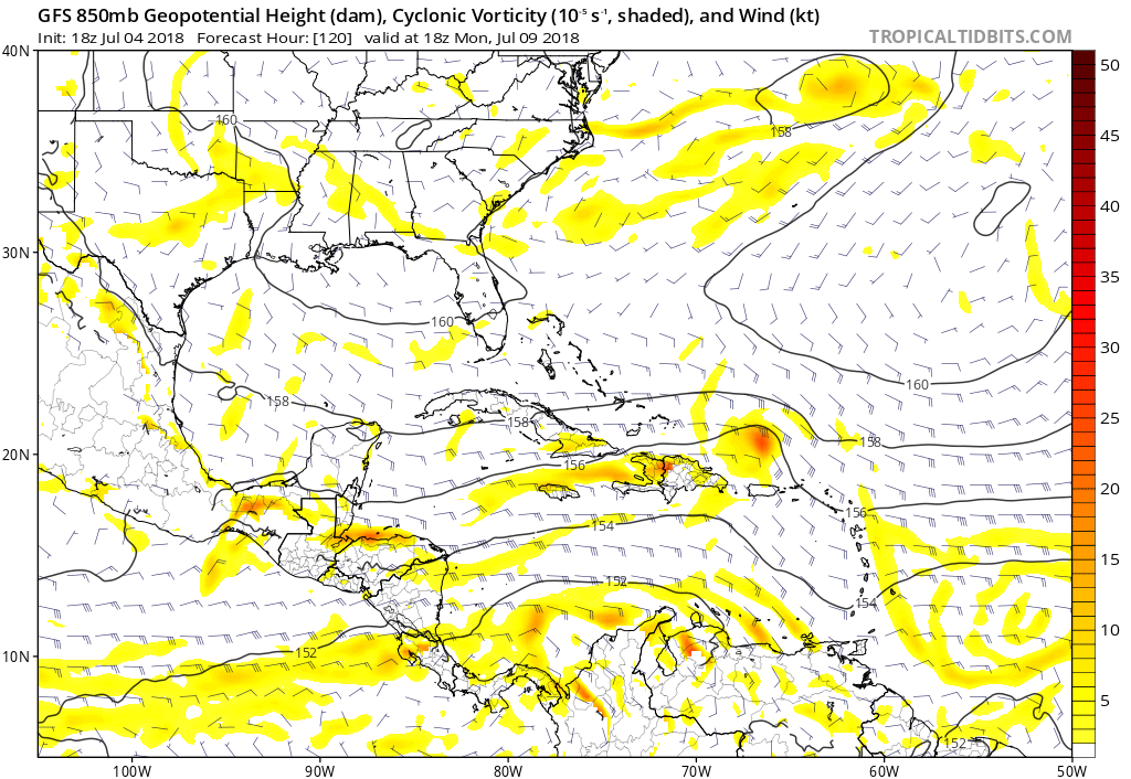
Here is the day 5 forecast from the 18Z GFS showing a bit more vorticity in the vicinity of Puerto Rico than the previous 12Z run:
1 likes

Re: ATL: INVEST 95L - Discussion
2 likes
The above post is not official and should not be used as such. It is the opinion of the poster and may or may not be backed by sound meteorological data. It is not endorsed by any professional institution or storm2k.org. For official information, please refer to the NHC and NWS products.
-
Yellow Evan

- Professional-Met

- Posts: 16214
- Age: 27
- Joined: Fri Jul 15, 2011 12:48 pm
- Location: Henderson, Nevada/Honolulu, HI
- Contact:
Re: ATL: INVEST 95L - Discussion
Hammy wrote::uarrow: Looks like a tropical storm if it can close off, and it certainly looks closed at cloud level given the low cloud motion.
ASCAT begs to differ despite SAB numbers of T2.5.
1 likes
-
djones65
- Category 1

- Posts: 264
- Age: 60
- Joined: Mon Jun 20, 2005 12:05 am
- Location: Ocean Springs, MS
Re: ATL: INVEST 95L - Discussion
I realize the ASCAT is inconclusive. However, to definitively state it is proof that a circulation does not exist is not fair either. As we all know ASCAT has a low wind bias AND this system is tracking westward pretty quickly... In my opinion at least 20 mph. And the circulation is pretty small. Which is subject to large errors from satellite derived winds. I will agree that as result of this image there is nothing conclusive to result in classification of a tropical depression. But it DEFINITELY does not rule it out.
I personally believe it is quite likely a surface circulation does exist, but the system is weak at the surface and the impressive turning is mostly 700 mb to 850 mb level at the moment.
I personally believe it is quite likely a surface circulation does exist, but the system is weak at the surface and the impressive turning is mostly 700 mb to 850 mb level at the moment.
2 likes
-
NotSparta

- Professional-Met
- Posts: 1676
- Age: 24
- Joined: Fri Aug 18, 2017 8:24 am
- Location: Naples, FL
- Contact:
Re: ATL: INVEST 95L - Discussion
Is this a band?
0 likes
This post was probably an opinion of mine, and in no way is official. Please refer to http://www.hurricanes.gov for official tropical analysis and advisories.
My website, with lots of tropical wx graphics, including satellite and recon: http://cyclonicwx.com
My website, with lots of tropical wx graphics, including satellite and recon: http://cyclonicwx.com
-
djones65
- Category 1
- Posts: 264
- Age: 60
- Joined: Mon Jun 20, 2005 12:05 am
- Location: Ocean Springs, MS
Re: ATL: INVEST 95L - Discussion
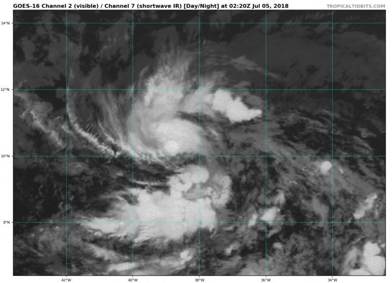
I just looked closely at another satellite loop of 95l. From Tropical Tidbits site. Perhaps this system is only a midlevel circulation. If you watch and it is time-sensitive, there appears to be another low level circulation trailing east southeast of the main mid level circulation by about 90 miles. I see a low level circulation near 9.6N and 36.9W whereas the convective circulation appears 10.5N and 38.6W. Does anyone else see what I am seeing? So, once again, perhaps the NHC had this right??? Otherwise what is the trailing low level turning I am seeing? And it makes sense since 95L is likely experiencing some east southeasterly shear...
0 likes
-
tolakram
- Admin
- Posts: 20170
- Age: 62
- Joined: Sun Aug 27, 2006 8:23 pm
- Location: Florence, KY (name is Mark)
Re: ATL: INVEST 95L - Discussion
It's moving pretty fast, we've seen this before ... where a circulation can't close off due to rapid west movement.
1 likes
M a r k
- - - - -
Join us in chat: Storm2K Chatroom Invite. Android and IOS apps also available.
The posts in this forum are NOT official forecasts and should not be used as such. Posts are NOT endorsed by any professional institution or STORM2K.org. For official information and forecasts, please refer to NHC and NWS products.
-
cycloneye
- Admin
- Posts: 148895
- Age: 69
- Joined: Thu Oct 10, 2002 10:54 am
- Location: San Juan, Puerto Rico
Re: ATL: INVEST 95L - Discussion
tolakram wrote:It's moving pretty fast, we've seen this before ... where a circulation can't close off due to rapid west movement.
Bret of 2017 comes to my memory that didn't last long.
2 likes
Visit the Caribbean-Central America Weather Thread where you can find at first post web cams,radars
and observations from Caribbean basin members Click Here
and observations from Caribbean basin members Click Here
Re: ATL: INVEST 95L - Discussion
cycloneye wrote:tolakram wrote:It's moving pretty fast, we've seen this before ... where a circulation can't close off due to rapid west movement.
Bret of 2017 comes to my memory that didn't last long.
dont think this will hit land like bret did though
1 likes
-
Aric Dunn
- Category 5

- Posts: 21238
- Age: 43
- Joined: Sun Sep 19, 2004 9:58 pm
- Location: Ready for the Chase.
- Contact:
Re: ATL: INVEST 95L - Discussion
THe odd thing i have been watching is the vort or other circ that is just to the SE of the convection a little way...
0 likes
Note: If I make a post that is brief. Please refer back to previous posts for the analysis or reasoning. I do not re-write/qoute what my initial post said each time.
If there is nothing before... then just ask
Space & Atmospheric Physicist, Embry-Riddle Aeronautical University,
I believe the sky is falling...
If there is nothing before... then just ask
Space & Atmospheric Physicist, Embry-Riddle Aeronautical University,
I believe the sky is falling...


Re: ATL: INVEST 95L - Models
UKMET has this finally:
NEW TROPICAL CYCLONE FORECAST TO DEVELOP AFTER 12 HOURS
FORECAST POSITION AT T+ 12 : 10.4N 40.3W
LEAD CENTRAL MAXIMUM WIND
VERIFYING TIME TIME POSITION PRESSURE (MB) SPEED (KNOTS)
-------------- ---- -------- ------------- -------------
1200UTC 05.07.2018 12 10.4N 40.3W 1010 30
0000UTC 06.07.2018 24 11.0N 42.3W 1010 29
1200UTC 06.07.2018 36 11.6N 44.4W 1011 32
0000UTC 07.07.2018 48 12.5N 46.5W 1011 32
1200UTC 07.07.2018 60 13.3N 49.2W 1012 32
0000UTC 08.07.2018 72 14.2N 52.3W 1013 31
1200UTC 08.07.2018 84 CEASED TRACKING
1 likes
-
Aric Dunn
- Category 5
- Posts: 21238
- Age: 43
- Joined: Sun Sep 19, 2004 9:58 pm
- Location: Ready for the Chase.
- Contact:
Re: ATL: INVEST 95L - Discussion
By the way the last couple hours or so has gone away from pulsating convection to an area that has maintained continuously redeveloping in the same location. that is typically a sure sign of a TC and low level convergence. if that continues the pressures will fall and any doubt about a closed circ from forward motion will be gone.
1 likes
Note: If I make a post that is brief. Please refer back to previous posts for the analysis or reasoning. I do not re-write/qoute what my initial post said each time.
If there is nothing before... then just ask
Space & Atmospheric Physicist, Embry-Riddle Aeronautical University,
I believe the sky is falling...
If there is nothing before... then just ask
Space & Atmospheric Physicist, Embry-Riddle Aeronautical University,
I believe the sky is falling...
-
NotSparta
- Professional-Met
- Posts: 1676
- Age: 24
- Joined: Fri Aug 18, 2017 8:24 am
- Location: Naples, FL
- Contact:
Re: ATL: INVEST 95L - Discussion
reminds me of those MCSs over the CONUS that have continuously firing convection

0 likes
This post was probably an opinion of mine, and in no way is official. Please refer to http://www.hurricanes.gov for official tropical analysis and advisories.
My website, with lots of tropical wx graphics, including satellite and recon: http://cyclonicwx.com
My website, with lots of tropical wx graphics, including satellite and recon: http://cyclonicwx.com
-
Aric Dunn
- Category 5
- Posts: 21238
- Age: 43
- Joined: Sun Sep 19, 2004 9:58 pm
- Location: Ready for the Chase.
- Contact:
Re: ATL: INVEST 95L - Discussion
NotSparta wrote::uarrow:
reminds me of those MCSs over the CONUS that have continuously firing convection
[img]https://i.imgur.com/0s5OZDO.gif[/ig]
Except for a different mechanism in the case of a TC.
1 likes
Note: If I make a post that is brief. Please refer back to previous posts for the analysis or reasoning. I do not re-write/qoute what my initial post said each time.
If there is nothing before... then just ask
Space & Atmospheric Physicist, Embry-Riddle Aeronautical University,
I believe the sky is falling...
If there is nothing before... then just ask
Space & Atmospheric Physicist, Embry-Riddle Aeronautical University,
I believe the sky is falling...
-
NotSparta
- Professional-Met
- Posts: 1676
- Age: 24
- Joined: Fri Aug 18, 2017 8:24 am
- Location: Naples, FL
- Contact:
Re: ATL: INVEST 95L - Discussion
TCFA issued.
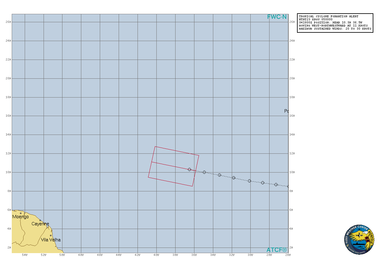
SUBJ/TROPICAL CYCLONE FORMATION ALERT//
WTNT23 KNGU 050000
RMKS/1. FORMATION OF A SIGNIFICANT TROPICAL CYCLONE IS POSSIBLE
WITHIN 100 NM EITHER SIDE OF A LINE FROM 10.2N 35.8W TO 11.1N 40.5W
WITHIN THE NEXT 24 HOURS. AVAILABLE DATA DOES NOT JUSTIFY
ISSUANCE OF NUMBERED TROPICAL CYCLONE WARNINGS AT THIS TIME.
WINDS IN THE AREA ARE ESTIMATED TO BE 20 TO 30 KNOTS. METSAT
IMAGERY AT 050000Z INDICATES THAT A CIRCULATION CENTER IS LOCATED
NEAR 10.3N 36.5W. THE SYSTEM IS MOVING WEST-NORTHWESTWARD AT 11
KNOTS.
2. REMARKS:MAXIMUM SUSTAINED SURFACE WINDS ARE ESTIMATED AT 20 TO 30
KNOTS. MINIMUM SEA LEVEL PRESSURE IS ESTIMATED TO BE NEAR 1000 MB.
THE POTENTIAL FOR THE DEVELOPMENT OF A SIGNIFICANT TROPICAL CYCLONE
WITHIN THE NEXT 24 HOURS IS HIGH. SHOWER AND THUNDERSTORM
ACTIVITY ASSOCIATED WITH LOW PRESSURE SYSTEM LOCATED SEVERAL
HUNDRED MILES WEST-SOUTHWEST OF THE CABO VERDE ISLANDS CONTINUES
TO BECOME BETTER ORGANZIED. EARLIER SATELLITE DERIVED WINDS AND
MICROWAVE IMAGES ALSO INDICATE THAT THE SURFACE CIRCULATION IS
BETTER DERIVED. IF THESE TRENDS CONTINUE A TROPICAL DEPRESSION IS
LIKELY TO FORM DURING THE NEXT 24 HOURS AS THE SYSTEM CONTINUES
TO MOVE WEST-NORTHWESTWARD AT 10 TO 15 KNOTS.
3. THIS ALERT WILL BE REISSUED, UPGRADED TO WARNING OR CANCELLED BY
060000Z.//
0 likes
This post was probably an opinion of mine, and in no way is official. Please refer to http://www.hurricanes.gov for official tropical analysis and advisories.
My website, with lots of tropical wx graphics, including satellite and recon: http://cyclonicwx.com
My website, with lots of tropical wx graphics, including satellite and recon: http://cyclonicwx.com
-
Aric Dunn
- Category 5
- Posts: 21238
- Age: 43
- Joined: Sun Sep 19, 2004 9:58 pm
- Location: Ready for the Chase.
- Contact:
Re: ATL: INVEST 95L - Discussion
convective pattern is improving every frame. very deep convection maintaining and expanding. should see TD at 5am. possible TS with some wind barbs at TS strength.
3 likes
Note: If I make a post that is brief. Please refer back to previous posts for the analysis or reasoning. I do not re-write/qoute what my initial post said each time.
If there is nothing before... then just ask
Space & Atmospheric Physicist, Embry-Riddle Aeronautical University,
I believe the sky is falling...
If there is nothing before... then just ask
Space & Atmospheric Physicist, Embry-Riddle Aeronautical University,
I believe the sky is falling...
-
AJC3

- Admin
- Posts: 4152
- Age: 62
- Joined: Tue Aug 31, 2004 7:04 pm
- Location: Ballston Spa, New York
- Contact:
Re: ATL: INVEST 95L - Discussion
Quick reminder...please keep any critiques of how the system is being handled respectful, professional, and, perhaps a little less...shall we say...emotional. Thanks.
4 likes
Re: ATL: INVEST 95L - Discussion
Upgrade looking unlikely at 5am given the convection starting to decline, the circulation doesn't appear any better established than earlier (when it was not fully closed) and there is usually some sort of announcement (at least last year) a half hour or so before that they're going to start advisories.
0 likes
The above post is not official and should not be used as such. It is the opinion of the poster and may or may not be backed by sound meteorological data. It is not endorsed by any professional institution or storm2k.org. For official information, please refer to the NHC and NWS products.

Re: ATL: INVEST 95L - Discussion
Hammy wrote:Upgrade looking unlikely at 5am given the convection starting to decline, the circulation doesn't appear any better established than earlier (when it was not fully closed) and there is usually some sort of announcement (at least last year) a half hour or so before that they're going to start advisories.
From Yesterday:
drezee Wed Jul 04, 2018 1:18 pm wrote:Love the NHC but...this is a classic Cape verde tropical depression...leading tail et al
I get it... no threat...no need to bring anyone in to write advisories...classify it tomorrow then update genesis post season....book it
Earliest would be 8am or more likely 11et. I think it is a min TS...if recon was inside
0 likes
Who is online
Users browsing this forum: No registered users and 59 guests