WDPN32 PGTW 100300
MSGID/GENADMIN/JOINT TYPHOON WRNCEN PEARL HARBOR HI//
SUBJ/PROGNOSTIC REASONING FOR TYPHOON 10W (MARIA) WARNING NR
30//
RMKS/
1. FOR METEOROLOGISTS.
2. 6 HOUR SUMMARY AND ANALYSIS.
TYPHOON (TY) 10W (MARIA), LOCATED APPROXIMATELY 153 NM SOUTH-
SOUTHWEST OF KADENA AB, HAS TRACKED WEST-NORTHWESTWARD AT 15 KNOTS
OVER THE PAST SIX HOURS. ANIMATED ENHANCED INFRARED SATELLITE
IMAGERY DEPICTS GRADUAL WEAKENING OF DEEP CONVECTION WITH A 30NM
OBLONG EYE, WHICH PROVIDES GOOD CONFIDENCE IN THE CURRENT POSITION.
A 092201Z SSMIS 91GHZ IMAGE REVEALS CONCENTRIC RINGS AND A DEFINED
MOAT INDICATIVE OF THE ONGOING EYEWALL REPLACEMENT CYCLE. THE
INITIAL INTENSITY IS ASSESSED AT 110 KNOTS BASED ON THE DVORAK
CURRENT INTENSITY ESTIMATES FROM KNES AND PGTW RANGING FROM 5.5 TO
6.0 (102-115 KNOTS) AND A SATCON ESTIMATE OF 106 KNOTS. THE 10/0110Z
ADVANCED DVORAK TECHNIQUE ESTIMATE IS SLIGHTLY LOWER AT 5.2 (95
KNOTS). UPPER-LEVEL ANALYSIS INDICATES NEAR-RADIAL OUTFLOW,
HOWEVER, POLEWARD OUTFLOW HAS WEAKENED OVER THE PAST 24 HOURS.
ADDITIONALLY, SST VALUES HAVE COOLED SLIGHTLY AS WELL AS A
SIGNIFICANT DECREASE IN OCEAN HEAT CONTENT VALUES. TY MARIA IS
CURRENTLY TRACKING WEST-NORTHWESTWARD ALONG AN EXTENSION OF THE DEEP
LAYERED SUBTROPICAL RIDGE (STR) WHICH IS LOCATED TO THE NORTHEAST.
3. FORECAST REASONING.
A. THERE IS NO CHANGE TO THE FORECAST PHILOSOPHY SINCE THE
PREVIOUS PROGNOSTIC REASONING MESSAGE.
B. TY 10W IS FORECAST TO CONTINUE TRACKING WEST-NORTHWESTWARD
ALONG THE SOUTHWESTERN EXTENSION OF THE AFOREMENTIONED STR. TY 10W
IS FORECAST TO WEAKEN SLOWLY THROUGH TAU 12 UNDER GENERALLY
FAVORABLE CONDITIONS. AFTER TAU 12, THE SYSTEM IS EXPECTED TO WEAKEN
SIGNIFICANTLY, AS IT TRACKS JUST NORTH OF TAIWAN, DUE TO INCREASING
FRICTIONAL EFFECTS. TY MARIA WILL MAKE LANDFALL NEAR TAU 24 AND WILL
WEAKEN RAPIDLY AS IT RECURVES OVER EASTERN CHINA WITH DISSIPATION
FORECAST BY TAU 72. NUMERICAL MODEL GUIDANCE REMAINS IN TIGHT
AGREEMENT, THEREFORE, THERE IS HIGH CONFIDENCE IN THE JTWC FORECAST
TRACK.//
NNNN
WPAC: MARIA - Post-Tropical
Moderator: S2k Moderators
-
mrbagyo

- Category 5

- Posts: 3963
- Age: 33
- Joined: Thu Apr 12, 2012 9:18 am
- Location: 14.13N 120.98E
- Contact:
Re: WPAC: MARIA - Typhoon
https://twitter.com/ExtremeStorms/status/1016545220966604800
JMA @ 968.1 - 14:00 local time
METAR - 967
METAR: ROMY 100500Z 02035G66KT 1000 R22/0900VP1800D SHRA FEW005 BKN009 SCT015CB 26/26 Q0967
JMA @ 968.1 - 14:00 local time
METAR - 967
METAR: ROMY 100500Z 02035G66KT 1000 R22/0900VP1800D SHRA FEW005 BKN009 SCT015CB 26/26 Q0967
0 likes
The posts in this forum are NOT official forecast and should not be used as such. They are just the opinion of the poster and may or may not be backed by sound meteorological data. They are NOT endorsed by any professional institution or storm2k.org. For official information, please refer to RSMC, NHC and NWS products.
-
mrbagyo
- Category 5
- Posts: 3963
- Age: 33
- Joined: Thu Apr 12, 2012 9:18 am
- Location: 14.13N 120.98E
- Contact:
Re: WPAC: MARIA - Typhoon
Twisted-core wrote::uarrow: Is that inside the eye or outta pressure.
Not yet in the inner eye, pressure still falling.
https://twitter.com/ExtremeStorms/status/1016554138706927616
0 likes
The posts in this forum are NOT official forecast and should not be used as such. They are just the opinion of the poster and may or may not be backed by sound meteorological data. They are NOT endorsed by any professional institution or storm2k.org. For official information, please refer to RSMC, NHC and NWS products.
-
mrbagyo
- Category 5
- Posts: 3963
- Age: 33
- Joined: Thu Apr 12, 2012 9:18 am
- Location: 14.13N 120.98E
- Contact:
Re: WPAC: MARIA - Typhoon
0 likes
The posts in this forum are NOT official forecast and should not be used as such. They are just the opinion of the poster and may or may not be backed by sound meteorological data. They are NOT endorsed by any professional institution or storm2k.org. For official information, please refer to RSMC, NHC and NWS products.
Re: WPAC: MARIA - Typhoon
Looks like central pressure is around 940 mb.
0 likes
Personal Forecast Disclaimer:
The posts in this forum are NOT official forecast and should not be used as such. They are just the opinion of the poster and may or may not be backed by sound meteorological data. They are NOT endorsed by any professional institution or storm2k.org. For official information, please refer to RSMC and NWS products.
The posts in this forum are NOT official forecast and should not be used as such. They are just the opinion of the poster and may or may not be backed by sound meteorological data. They are NOT endorsed by any professional institution or storm2k.org. For official information, please refer to RSMC and NWS products.
-
mrbagyo
- Category 5
- Posts: 3963
- Age: 33
- Joined: Thu Apr 12, 2012 9:18 am
- Location: 14.13N 120.98E
- Contact:
Re: WPAC: MARIA - Typhoon
Latest METAR - about 20 mins ago.
950 mb
METAR: ROMY 100600Z 36040G65KT 330V040 1000 R22/0550V1600D +SHRA SCT004 BKN009 SCT015CB 26/26 Q0950
950 mb
METAR: ROMY 100600Z 36040G65KT 330V040 1000 R22/0550V1600D +SHRA SCT004 BKN009 SCT015CB 26/26 Q0950
0 likes
The posts in this forum are NOT official forecast and should not be used as such. They are just the opinion of the poster and may or may not be backed by sound meteorological data. They are NOT endorsed by any professional institution or storm2k.org. For official information, please refer to RSMC, NHC and NWS products.
-
mrbagyo
- Category 5
- Posts: 3963
- Age: 33
- Joined: Thu Apr 12, 2012 9:18 am
- Location: 14.13N 120.98E
- Contact:
Re: WPAC: MARIA - Typhoon
Eye!!!
946 mb inside the eye according to Jim Edds
JMA has it at 945.7 mb - 16:00 local
METAR (ROMY) - 945 mb
METAR: ROMY 100700Z 11009KT 070V140 2000 R22/0900V1600U -SHRA BR FEW004 BKN012 27/27 Q0945
ADT @ 950 to 951 mb
946 mb inside the eye according to Jim Edds
JMA has it at 945.7 mb - 16:00 local
METAR (ROMY) - 945 mb
METAR: ROMY 100700Z 11009KT 070V140 2000 R22/0900V1600U -SHRA BR FEW004 BKN012 27/27 Q0945
ADT @ 950 to 951 mb
0 likes
The posts in this forum are NOT official forecast and should not be used as such. They are just the opinion of the poster and may or may not be backed by sound meteorological data. They are NOT endorsed by any professional institution or storm2k.org. For official information, please refer to RSMC, NHC and NWS products.
-
mrbagyo
- Category 5
- Posts: 3963
- Age: 33
- Joined: Thu Apr 12, 2012 9:18 am
- Location: 14.13N 120.98E
- Contact:
Re: WPAC: MARIA - Typhoon
Mega Eye.

0 likes
The posts in this forum are NOT official forecast and should not be used as such. They are just the opinion of the poster and may or may not be backed by sound meteorological data. They are NOT endorsed by any professional institution or storm2k.org. For official information, please refer to RSMC, NHC and NWS products.

-
euro6208
Re: WPAC: MARIA - Typhoon

WDPN32 PGTW 100900
MSGID/GENADMIN/JOINT TYPHOON WRNCEN PEARL HARBOR HI//
SUBJ/PROGNOSTIC REASONING FOR TYPHOON 10W (MARIA) WARNING NR
31//
RMKS/
1. FOR METEOROLOGISTS.
2. 6 HOUR SUMMARY AND ANALYSIS.
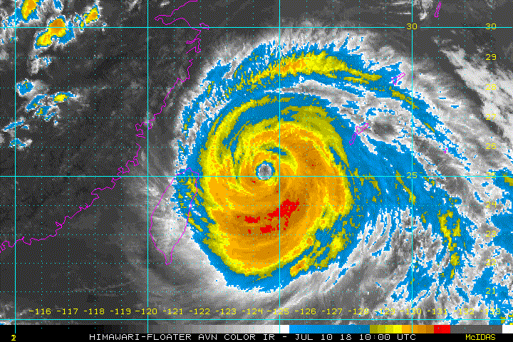
TYPHOON (TY) 10W (MARIA), LOCATED APPROXIMATELY 165 NM SOUTHWEST
OF
KADENA AB, OKINAWA, JAPAN, HAS TRACKED WEST-NORTHWESTWARD AT 16
KNOTS
OVER THE PAST SIX HOURS. ANIMATED MULTISPECTRAL SATELLITE IMAGERY
(MSI) SHOWS THE SYSTEM HAS MAINTAINED A LARGE AND RAGGED 30-NM EYE,
THE RESULT OF A PREVIOUS EYE WALL REPLACEMENT. SPIRAL BANDS HAVE ALSO
REMAINED TIGHTLY WRAPPED AND FEEDING INTO THE EYE WITH MINOR SIGNS OF
FRAGMENTATION AND WARMING ALONG THE CONVECTIVE TOPS. THE INITIAL
POSITION IS PLACED WITH HIGH CONFIDENCE SLIGHTLY BEHIND THE EYE
FEATURE IN THE MSI LOOP TO ACCOUNT FOR A SMALL SLANT AS EVIDENCED BY
A WELL-DEFINED MICROWAVE EYE IN THE 100449Z ATMS PASS SLIGHTLY
TRAILING THE 100450Z 1KM VIS EYE. THE INITIAL INTENSITY OF 110 KNOTS
IS BASED ON AN OVERALL ASSESSMENT OF AGENCY AND OBJECTIVE DVORAK
ESTIMATES. UPPER-LEVEL ANALYSIS INDICATES NEAR-RADIAL OUTFLOW WITH A
WEAKENING POLEWARD CHANNEL. ALONG-TRACK SST VALUES REMAIN WARM AND
CONDUCIVE AT 29 CELSIUS. THE CYCLONE IS TRACKING ALONG AN EXTENSION
OF THE DEEP-LAYERED SUBTROPICAL RIDGE (STR) THE NORTHEAST.
3. FORECAST REASONING.
A. THERE IS NO CHANGE TO THE FORECAST PHILOSOPHY SINCE THE
PREVIOUS PROGNOSTIC REASONING MESSAGE.
B. STEERED BY THE STR, TY MARIA IS FORECAST TO CONTINUE TRACKING
WEST-NORTHWESTWARD FOR THE REMAINDER OF THE FORECAST. AS OUTFLOW
WEAKENS AND SSTS BEGIN TO COOL, THE SYSTEM WILL GRADUALLY WEAKEN AND
NEAR TAU 18, AFTER IT MAKES LANDFALL NEAR FOZHOU, CHINA, WILL RAPIDLY
ERODE AS IT TRACKS ACROSS THE RUGGED TERRAIN OF INLAND CHINA. BY TAU
48, IT WILL BE REDUCED TO A 30-KNOT DEPRESSION OVER LAND. NUMERICAL
MODEL GUIDANCE REMAINS IN TIGHT AGREEMENT, THEREFORE, THERE IS HIGH
CONFIDENCE IN THE JTWC FORECAST TRACK.//
NNNN
Impressive...

Closeup of the expected landfall. Now zeroing on +2.8 million Ningde. Not far north from Fuzhou.

0 likes
-
euro6208
Re: WPAC: MARIA - Typhoon
TPPN11 PGTW 100917
A. TYPHOON 10W (MARIA)
B. 10/0830Z
C. 24.93N
D. 124.84E
E. THREE/HMWRI8
F. T5.0/5.5/W1.0/24HRS STT: S0.0/03HRS
G. IR/EIR
H. REMARKS: 09A/PBO RAGGED EYE/ANMTN. WMG EYE SURROUNDED BY MG
YIELDS AN E# OF 4.5. ADDED 0.5 FOR EYE ADJUSTMENT TO YIELD A DT
OF 5.0. MET AND PT AGREE. DBO DT.
I. ADDITIONAL POSITIONS:
10/0449Z 24.52N 125.77E ATMS
10/0558Z 24.77N 125.42E SSMI
10/0728Z 24.77N 125.23E MMHS
10/0740Z 24.80N 125.08E SSMS
LOWE
TXPQ21 KNES 100907
TCSWNP
A. 10W (MARIA)
B. 10/0830Z
C. 24.9N
D. 124.8E
E. ONE/HIMAWARI-8
F. T5.0/5.0/W1.0/24HRS
G. IR/EIR/VIS
H. REMARKS...THIS INTENSITY ESTIMATE WAS DERIVED USING 4 KM IR
DATA. SYSTEM CHARACTERIZED BY A WMG EYE SURROUNDED BY LG AND EMBEDDED
IN MG FOR A DT=5.0 AFTER ADDING 0.5 FOR AN EYE ADJUSTMENT. MET=5.5
PT=5.0. FT IS BASED ON DT.
I. ADDL POSITIONS
NIL
...FISHER
0 likes

-
doomhaMwx

- Category 5
- Posts: 2487
- Age: 27
- Joined: Tue Apr 18, 2017 4:01 am
- Location: Baguio/Benguet, Philippines
- Contact:
Re: WPAC: MARIA - Typhoon
0 likes
-
mrbagyo
- Category 5
- Posts: 3963
- Age: 33
- Joined: Thu Apr 12, 2012 9:18 am
- Location: 14.13N 120.98E
- Contact:
Re: WPAC: MARIA - Typhoon
2 likes
The posts in this forum are NOT official forecast and should not be used as such. They are just the opinion of the poster and may or may not be backed by sound meteorological data. They are NOT endorsed by any professional institution or storm2k.org. For official information, please refer to RSMC, NHC and NWS products.
-
mrbagyo
- Category 5
- Posts: 3963
- Age: 33
- Joined: Thu Apr 12, 2012 9:18 am
- Location: 14.13N 120.98E
- Contact:
Re: WPAC: MARIA - Typhoon
I think Maria is attempting to go Annular before landfall - I don't know if she had enough time to pull the trick but what I'm sure is that she carries a massive storm surge potential- she has the size, strength, speed, right angle of approach and favorable bathymetry.
0 likes
The posts in this forum are NOT official forecast and should not be used as such. They are just the opinion of the poster and may or may not be backed by sound meteorological data. They are NOT endorsed by any professional institution or storm2k.org. For official information, please refer to RSMC, NHC and NWS products.
-
cycloneye

- Admin

- Posts: 149367
- Age: 69
- Joined: Thu Oct 10, 2002 10:54 am
- Location: San Juan, Puerto Rico
Re: WPAC: MARIA - Typhoon
JMA at 85 kts.
TY 1808 (Maria)
Issued at 19:45 UTC, 10 July 2018
<Analysis at 19 UTC, 10 July>
Scale -
Intensity Very strong
Center position N26°20' (26.3°)
E121°55' (121.9°)
Direction and speed of movement WNW 30 km/h (17 kt)
Central pressure 955 hPa
Maximum wind speed near center 45 m/s (85 kt)
Maximum wind gust speed 60 m/s (120 kt)
≥ 50 kt wind area ALL 170 km (90 NM)
≥ 30 kt wind area NE 500 km (270 NM)
SW 330 km (180 NM)
<Estimate for 20 UTC, 10 July>
Scale -
Intensity Very strong
Center position N26°25' (26.4°)
E121°35' (121.6°)
Direction and speed of movement WNW 30 km/h (17 kt)
Central pressure 955 hPa
Maximum wind speed near center 45 m/s (85 kt)
Maximum wind gust speed 60 m/s (120 kt)
≥ 50 kt wind area ALL 170 km (90 NM)
≥ 30 kt wind area NE 500 km (270 NM)
SW 330 km (180 NM)
<Forecast for 06 UTC, 11 July>
Intensity -
Center position of probability circle N26°55' (26.9°)
E118°20' (118.3°)
Direction and speed of movement W 35 km/h (18 kt)
Central pressure 980 hPa
Maximum sustained wind speed 25 m/s (50 kt)
Maximum wind gust speed 35 m/s (70 kt)
Radius of probability circle 70 km (40 NM)
<Forecast for 18 UTC, 11 July>
Intensity -
Center position of probability circle N28°25' (28.4°)
E115°30' (115.5°)
Direction and speed of movement WNW 25 km/h (14 kt)
Central pressure 992 hPa
Maximum sustained wind speed 18 m/s (35 kt)
Maximum wind gust speed 25 m/s (50 kt)
Radius of probability circle 110 km (60 NM)
<Forecast for 18 UTC, 12 July>
Intensity -
TD
Center position of probability circle N31°30' (31.5°)
E112°20' (112.3°)
Direction and speed of movement NW 20 km/h (10 kt)
Central pressure 1000 hPa
Radius of probability circle 180 km (95 NM)
0 likes
Visit the Caribbean-Central America Weather Thread where you can find at first post web cams,radars
and observations from Caribbean basin members Click Here
and observations from Caribbean basin members Click Here
-
Yellow Evan

- Professional-Met

- Posts: 16232
- Age: 27
- Joined: Fri Jul 15, 2011 12:48 pm
- Location: Henderson, Nevada/Honolulu, HI
- Contact:
Re: WPAC: MARIA - Typhoon
Not sure if this is a major hurricane anymore but regardless, this poses a 3 way storm threat of surge, winds, and flooding rains. Eyewall starting to brush the China coastline.
Last edited by Yellow Evan on Tue Jul 10, 2018 4:55 pm, edited 1 time in total.
0 likes
-
euro6208
Re: WPAC: MARIA - Typhoon


WDPN32 PGTW 102100
MSGID/GENADMIN/JOINT TYPHOON WRNCEN PEARL HARBOR HI//
SUBJ/PROGNOSTIC REASONING FOR TYPHOON 10W (MARIA) WARNING NR 33//
RMKS/
1. FOR METEOROLOGISTS.
2. 6 HOUR SUMMARY AND ANALYSIS.
TYPHOON (TY) 10W (MARIA), LOCATED APPROXIMATELY 76 NM NORTH-
NORTHEAST OF TAIPEI, TAIWAN, HAS TRACKED WEST-NORTHWESTWARD AT 19
KNOTS OVER THE PAST SIX HOURS. ANIMATED ENHANCED INFRARED (EIR)
SATELLITE IMAGERY DEPICTS A GRADUAL WEAKENING SYSTEM WITH DEEP
CONVECTIVE BANDING WRAPPING AROUND A 30NM OBLONG EYE. EIR ALSO
INDICATES SOME EROSION OF DEEP CONVECTION OVER THE SOUTHWEST
QUADRANT DUE TO THE INITIAL INTERACTION WITH TAIWAN. OVERALL, THERE
IS GOOD CONFIDENCE IN THE INITIAL POSITION. THE INITIAL INTENSITY IS
ASSESSED AT 100 KNOTS BASED ON DVORAK CURRENT INTENSITY ESTIMATES OF
5.5 (102 KNOTS) FROM BOTH PGTW AND RJTD. UPPER-LEVEL ANALYSIS
INDICATES RADIAL OUTFLOW, HOWEVER, TY 10W CONTINUES TO WEAKEN DUE TO
INCREASING NORTHERLY VERTICAL WIND SHEAR (15 TO 20 KNOTS), SLIGHTLY
COOLER SST (28C) AND VERY LOW OCEAN HEAT CONTENT VALUES. TY MARIA IS
CURRENTLY TRACKING ALONG THE SOUTHWEST PERIPHERY OF THE DEEP-LAYERED
SUBTROPICAL RIDGE (STR).
3. FORECAST REASONING.
A. THERE IS NO CHANGE TO THE FORECAST PHILOSOPHY SINCE THE
PREVIOUS PROGNOSTIC REASONING MESSAGE.
B. TY MARIA IS FORECAST TO CONTINUE TRACKING WEST-NORTHWESTWARD
TO NORTHWESTWARD ALONG THE SOUTHWEST PERIPHERY OF THE STR THROUGH
THE FORECAST PERIOD. AFTER MAKING LANDFALL NEAR TAU 06, TY 10W WILL
WEAKEN RAPIDLY AND IS EXPECTED TO DISSIPATE BY TAU 48. NUMERICAL
MODEL GUIDANCE REMAINS IN TIGHT AGREEMENT, LENDING HIGH CONFIDENCE
IN THE JTWC FORECAST TRACK.//
NNNN
0 likes
-
1900hurricane

- Category 5
- Posts: 6063
- Age: 34
- Joined: Fri Feb 06, 2015 12:04 pm
- Location: Houston, TX
- Contact:
Re: WPAC: MARIA - Typhoon
Using the lowest pressure from Miyakojima that I found (945 mb), I end up with a range from 95 kt (background pressure adjusted AH77) to 105 kt (KZC). The one place where I've found AH77 to shine is in concentric eyewall situations, hence its use here. Wind reports definitely seemed on the lower end of the spectrum (highest gust I saw was only about 88 kt). I probably wouldn't go any higher than 95 kt for the intensity when Maria crossed Miyakojima, which was around 06Z yesterday.
0 likes
Contract Meteorologist. TAMU & MSST. Fiercely authentic, one of a kind. We are all given free will, so choose a life meant to be lived. We are the Masters of our own Stories.
Opinions expressed are mine alone.
Follow me on Twitter at @1900hurricane : Read blogs at https://1900hurricane.wordpress.com/
Opinions expressed are mine alone.
Follow me on Twitter at @1900hurricane : Read blogs at https://1900hurricane.wordpress.com/
Who is online
Users browsing this forum: No registered users and 9 guests