Texas Summer 2018
Moderator: S2k Moderators
Forum rules

The posts in this forum are NOT official forecast and should not be used as such. They are just the opinion of the poster and may or may not be backed by sound meteorological data. They are NOT endorsed by any professional institution or STORM2K.
-
Haris

- Category 5

- Posts: 1814
- Joined: Mon Nov 27, 2017 8:19 pm
- Location: ( Bee Cave) West Austin, Texas
Re: Texas Summer 2018
Weeklies ! ! !
1 likes
Weather geek and a storm spotter in West Austin. Not a degreed meteorologist. Big snow fan. Love rain and cold! Despise heat!


Re: Texas Summer 2018
The euro has changed its tune of late. Looking at some trof to meander through Texas creating a rainy pattern (with tropical moisture streaming north as well). Also period of below normal.
https://twitter.com/MJVentrice/status/1025343373580922881
Also if you are into the tropical cyclones thing both the WPAC and EPAC will be active with picturesque systems and worth the follow.
https://twitter.com/MJVentrice/status/1025343373580922881
Also if you are into the tropical cyclones thing both the WPAC and EPAC will be active with picturesque systems and worth the follow.
1 likes
The above post and any post by Ntxw is NOT an official forecast and should not be used as such. It is just the opinion of the poster and may or may not be backed by sound meteorological data. It is NOT endorsed by any professional institution including Storm2k. For official information, please refer to NWS products.
Help support Storm2K!
-
weatherdude1108
- Category 5
- Posts: 4228
- Joined: Tue Dec 13, 2011 1:04 pm
- Location: Northwest Austin/Cedar Park, TX
Re: Texas Summer 2018
Ntxw wrote:The euro has changed its tune of late. Looking at some trof to meander through Texas creating a rainy pattern (with tropical moisture streaming north as well). Also period of below normal.
https://twitter.com/MJVentrice/status/1025343373580922881
Also if you are into the tropical cyclones thing both the WPAC and EPAC will be active with picturesque systems and worth the follow.
Our local tv weather met mentioned this morning that next Thursday, a pattern change would be commencing (rain chances increasing).
1 likes
The preceding post is NOT an official forecast, and should not be used as such. It is only the opinion of the poster and may or may not be backed by sound meteorological data. It is NOT endorsed by any professional institution including storm2k.org. For Official Information please refer to the NHC and NWS products.
-
weatherdude1108
- Category 5
- Posts: 4228
- Joined: Tue Dec 13, 2011 1:04 pm
- Location: Northwest Austin/Cedar Park, TX
Re: Texas Summer 2018
000
FXUS64 KEWX 030823
AFDEWX
Area Forecast Discussion
National Weather Service Austin/San Antonio TX
323 AM CDT Fri Aug 3 2018
.SHORT TERM (Today through Saturday)...
The upper level pattern this morning is dominated by the western
U.S. high pressure ridge centered over the desert southwest along
with an upper level trough to the east. This trough axis stretches from
the upper Great Lakes down to the Lower MS Valley. South Central
Texas is stuck between these two systems and our weather will remain
fairly quiet in the short term. No real trigger for convection this
afternoon so will continue a dry forecast for at least one more day
with high temperatures at or slightly above average for this time of
year. With the upper ridge centered far from Texas, we are avoiding
the extreme heat. The overnight lows have been challenging as of late
with outflows, north winds from the recent front, etc. Think they
will start to level out a bit as a deeper southerly flow develops
into the weekend. On Saturday we will see the 20-40 percent pop come
back into the forecast over the SE zones as a weak inverted trough
and upper level weakness develops along and just off the coast. This
will also keep Saturday max temps down by a few degrees.
&&
.LONG TERM (Saturday Night through Thursday)...
The inverted trough mentioned above will move farther
into northern Mexico and South Texas Sunday and Monday. This will
set up slightly better pops for the eastern half of the CWA,
unfortunately the pop will remain low to nil across the western
half. This weakness in the upper flow will move out of the area by
mid week and we will see the pop decrease and temps warm by Tue and
Wed. With the upper ridge centered out west cant rule out low pop
along the SE zones with seabreeze type convection. Both the GFS and
ECMWF show a more amplified upper pattern late next week with a
similar look to a few days ago...the pattern that brought down some
outflow boundaries and the weak cool front. Its too early to tell
right now, but late next week may see some convection to our north
which could at least impact our northern zones with either some
outflows and/or convection. WPC currently is drawing in a stationary
front near the OK/TX border Wed and Thu. With that in mind, am
carrying some slight and chance pop Thu and Fri across the northern
half of the CWA to blend in with my neighbors to the north.
0 likes
The preceding post is NOT an official forecast, and should not be used as such. It is only the opinion of the poster and may or may not be backed by sound meteorological data. It is NOT endorsed by any professional institution including storm2k.org. For Official Information please refer to the NHC and NWS products.
-
Ralph's Weather
- S2K Supporter

- Posts: 3371
- Age: 38
- Joined: Fri Dec 13, 2013 11:55 am
- Location: Lindale, TX
- Contact:
Re: Texas Summer 2018
65, 64 and 63 degree mornings to start August is amazing. A few 50s even NE of here.
2 likes
Follow on Facebook at Ralph's Weather.
-
Haris
- Category 5
- Posts: 1814
- Joined: Mon Nov 27, 2017 8:19 pm
- Location: ( Bee Cave) West Austin, Texas
Re: Texas Summer 2018
I'm always hesitant trusting long range wet patterns in TX during the summer esp but this is looking clear as glass to me. Confidence for this materializing is 40% IMHO
3 likes
Weather geek and a storm spotter in West Austin. Not a degreed meteorologist. Big snow fan. Love rain and cold! Despise heat!
-
weatherdude1108
- Category 5
- Posts: 4228
- Joined: Tue Dec 13, 2011 1:04 pm
- Location: Northwest Austin/Cedar Park, TX
Re: Texas Summer 2018
Haris wrote:I'm always hesitant trusting long range wet patterns in TX during the summer esp but this is looking clear as glass to me. Confidence for this materializing is 40% IMHO
I hesitate too, but this GFS model is a good sign!
I couldn't get the FV3-GFS or GEFS to load yet.

2 likes
The preceding post is NOT an official forecast, and should not be used as such. It is only the opinion of the poster and may or may not be backed by sound meteorological data. It is NOT endorsed by any professional institution including storm2k.org. For Official Information please refer to the NHC and NWS products.
-
Haris
- Category 5
- Posts: 1814
- Joined: Mon Nov 27, 2017 8:19 pm
- Location: ( Bee Cave) West Austin, Texas
Re: Texas Summer 2018
Euro = heaven
like 5+ days of heavy rain and a 3-4" swath across the middle of TX! And it rains more beyond the run
like 5+ days of heavy rain and a 3-4" swath across the middle of TX! And it rains more beyond the run
2 likes
Weather geek and a storm spotter in West Austin. Not a degreed meteorologist. Big snow fan. Love rain and cold! Despise heat!
Re: Texas Summer 2018
Yep, 12z Euro continues the latest trend with a trof meandering Texas. Creates unsettled weather and many opportunities for heavy rain along with cooler temperatures.
3 likes
The above post and any post by Ntxw is NOT an official forecast and should not be used as such. It is just the opinion of the poster and may or may not be backed by sound meteorological data. It is NOT endorsed by any professional institution including Storm2k. For official information, please refer to NWS products.
Help support Storm2K!
Help support Storm2K!
-
srainhoutx

- S2K Supporter
- Posts: 6919
- Age: 68
- Joined: Sun Jan 14, 2007 11:34 am
- Location: Haywood County, NC
- Contact:
Re: Texas Summer 2018
The afternoon Updated CPC Day 6 to 10/8 to 14 and even the Experimental Week 3 and Week 4 Outlooks suggest above normal rainfall for our Region and below normal temperatures. It appears we may have a trend brewing... 
5 likes
Carla/Alicia/Jerry(In The Eye)/Michelle/Charley/Ivan/Dennis/Katrina/Rita/Wilma/Ike/Harvey
Member: National Weather Association
Wx Infinity Forums
http://wxinfinity.com/index.php
Facebook.com/WeatherInfinity
Twitter @WeatherInfinity
Member: National Weather Association
Wx Infinity Forums
http://wxinfinity.com/index.php
Facebook.com/WeatherInfinity
Twitter @WeatherInfinity
-
Haris
- Category 5
- Posts: 1814
- Joined: Mon Nov 27, 2017 8:19 pm
- Location: ( Bee Cave) West Austin, Texas
Re: Texas Summer 2018

Can someone also lock the EPS?
3 likes
Weather geek and a storm spotter in West Austin. Not a degreed meteorologist. Big snow fan. Love rain and cold! Despise heat!
Re: Texas Summer 2018
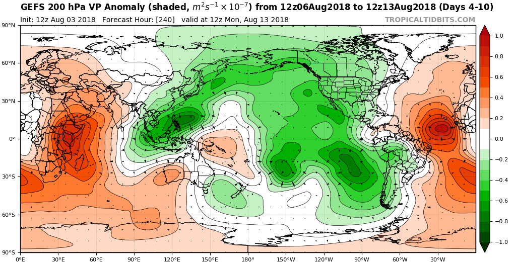
Of note while we do not yet have an official Oceanic Nino, bulk of rising motion the next several weeks will be in the Pacific. It's basically telling us we are going into Nino-like forcing for awhile with constructive interference. This can be seen as the tropical forcing has up-ticked the Eastern Pacific and later perhaps the western Gulf.
2 likes
The above post and any post by Ntxw is NOT an official forecast and should not be used as such. It is just the opinion of the poster and may or may not be backed by sound meteorological data. It is NOT endorsed by any professional institution including Storm2k. For official information, please refer to NWS products.
Help support Storm2K!
Help support Storm2K!
-
srainhoutx
- S2K Supporter
- Posts: 6919
- Age: 68
- Joined: Sun Jan 14, 2007 11:34 am
- Location: Haywood County, NC
- Contact:
Re: Texas Summer 2018
Ntxw wrote:Of note while we do not yet have an official Oceanic Nino, bulk of rising motion the next several weeks will be in the Pacific. It's basically telling us we are going into Nino-like forcing for awhile with constructive interference. This can be seen as the tropical forcing has up-ticked the Eastern Pacific and later perhaps the western Gulf.
We need to be very mindful that it is not uncommon to see some spurious tropical development occur, particularly in the Bay of Campeche and the Western Gulf in such a pattern. I know that this is not a Tropical Thread, but I have been expressing some concern on the KHOU Board about the potential of some "home grown" tropical mischief potentially spinning up around mid August to near mid September.
1 likes
Carla/Alicia/Jerry(In The Eye)/Michelle/Charley/Ivan/Dennis/Katrina/Rita/Wilma/Ike/Harvey
Member: National Weather Association
Wx Infinity Forums
http://wxinfinity.com/index.php
Facebook.com/WeatherInfinity
Twitter @WeatherInfinity
Member: National Weather Association
Wx Infinity Forums
http://wxinfinity.com/index.php
Facebook.com/WeatherInfinity
Twitter @WeatherInfinity
Re: Texas Summer 2018
srainhoutx wrote:We need to be very mindful that it is not uncommon to see some spurious tropical development occur, particularly in the Bay of Campeche and the Western Gulf in such a pattern. I know that this is not a Tropical Thread, but I have been expressing some concern on the KHOU Board about the potential of some "home grown" tropical mischief potentially spinning up around mid August to near mid September.
Last year as a prime example. While the MDR and Carib will be dead until then, the W Gulf can benefit from such a change of flow and spin up. At the very least we should see a surge of moisture coming up.
2 likes
The above post and any post by Ntxw is NOT an official forecast and should not be used as such. It is just the opinion of the poster and may or may not be backed by sound meteorological data. It is NOT endorsed by any professional institution including Storm2k. For official information, please refer to NWS products.
Help support Storm2K!
Help support Storm2K!
-
FunNestlé
Re: Texas Summer 2018
Finally! The weather returns back to normal after the wacky-jetstream induced dry spell that occured for much of July.
2 likes
-
Brent
- S2K Supporter
- Posts: 38755
- Age: 37
- Joined: Sun May 16, 2004 10:30 pm
- Location: Tulsa Oklahoma
- Contact:
Re: Texas Summer 2018
Looking at the Euro lets me have hope the worst of summer is behind us... 
3 likes
#neversummer
-
bubba hotep

- S2K Supporter
- Posts: 6014
- Joined: Wed Dec 28, 2016 1:00 am
- Location: Collin County Texas
Re: Texas Summer 2018
Ntxw wrote:Of note while we do not yet have an official Oceanic Nino, bulk of rising motion the next several weeks will be in the Pacific. It's basically telling us we are going into Nino-like forcing for awhile with constructive interference. This can be seen as the tropical forcing has up-ticked the Eastern Pacific and later perhaps the western Gulf.
When you look at the low frequency state, it is pretty obvious that the nino standing wave is emerging. It is just a matter of time now, given the atmosphere is interacting with the warm pool. I know a lot of people get hung up on the little boxes but the coupled base state is steadily shifting towards nino.
4 likes
Winter time post are almost exclusively focused on the DFW area.
-
Haris
- Category 5
- Posts: 1814
- Joined: Mon Nov 27, 2017 8:19 pm
- Location: ( Bee Cave) West Austin, Texas
Re: Texas Summer 2018
rip to folks S of NTX per GFS . lol. lots of flip flops with this one i feel
0 likes
Weather geek and a storm spotter in West Austin. Not a degreed meteorologist. Big snow fan. Love rain and cold! Despise heat!

Re: Texas Summer 2018
Haris wrote:rip to folks S of NTX per GFS . lol. lots of flip flops with this one i feel
Lol yeah nothing is set in stone that’s for sure. I don’t have my hopes up I can tell you that much.
0 likes
-
Haris
- Category 5
- Posts: 1814
- Joined: Mon Nov 27, 2017 8:19 pm
- Location: ( Bee Cave) West Austin, Texas
Re: Texas Summer 2018
Another fantastic run where the Trough gets stuck . 2-3” Austin , 2-4”+ NTX
3 likes
Weather geek and a storm spotter in West Austin. Not a degreed meteorologist. Big snow fan. Love rain and cold! Despise heat!