WPAC: HECTOR - Post-Tropical

Moderator: S2k Moderators

Message
Author
User avatar
Kingarabian
S2K Supporter
S2K Supporter
Posts: 15980
Joined: Sat Aug 08, 2009 3:06 am
Location: Honolulu, Hawaii

Re: EPAC: HECTOR - Hurricane

#321 Postby Kingarabian » Fri Aug 03, 2018 3:12 pm

Ntxw wrote:[img]http://i64.tinypic.com/nyh91v.jpg[img]


Wow, I'd go straight to MH here.
1 likes   
RIP Kobe Bryant

storminabox
Category 1
Category 1
Posts: 263
Joined: Sun Jul 09, 2017 10:50 pm

Re: EPAC: HECTOR - Hurricane

#322 Postby storminabox » Fri Aug 03, 2018 3:36 pm

Kingarabian wrote:
Ntxw wrote:[img]http://i64.tinypic.com/nyh91v.jpg[img]


Wow, I'd go straight to MH here.


I’m excited to see what the NHC does for this advisory.
0 likes   

CrazyC83
Professional-Met
Professional-Met
Posts: 34002
Joined: Tue Mar 07, 2006 11:57 pm
Location: Deep South, for the first time!

Re: EPAC: HECTOR - Hurricane

#323 Postby CrazyC83 » Fri Aug 03, 2018 3:40 pm

Ntxw wrote:Image


Yeah, I'd probably go with 105 kt. I agree I am very skeptical of it making it all the way to Asia, that is beyond fantasyland. Maybe getting past 180, yes, but that would be historic for an EPAC storm to make it all the way to Asia.
6 likes   

User avatar
cycloneye
Admin
Admin
Posts: 145308
Age: 68
Joined: Thu Oct 10, 2002 10:54 am
Location: San Juan, Puerto Rico

Re: EPAC: HECTOR - Hurricane

#324 Postby cycloneye » Fri Aug 03, 2018 3:50 pm

P5

Hurricane Hector Discussion Number 13
NWS National Hurricane Center Miami FL EP102018
200 PM PDT Fri Aug 03 2018

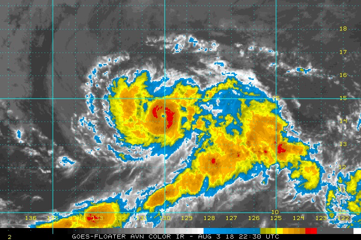
Satellite images indicate that Hector is re-strengthening. The eye
has cleared out again on visible imagery, with an increase in
deep convection in the eyewall. Perhaps this shouldn't be a
surprise because of Hector's small size, since these systems
are known to fluctuate up and down rapidly. The initial intensity
is set to 90 kt, between the 75 kt SATCON from CIMSS and a 102 kt
estimate from SAB. The large-scale environment would seem to favor
some intensification of Hector during the next couple of days, with
SSTS of 27-27.5C, light shear, and moderate levels of mid-level
moisture forecast. The new NHC forecast favors the dynamical models
over the more statistical-based guidance and shows steady
strengthening. This should be considered a low-confidence forecast
due to the divergent guidance and the small size of Hector. At the
end of the forecast, some weakening is shown due to increasing
dryness in the mid-levels and a potential increase in shear.

The initial motion remains 270/10 kt. There has been no change to
the synoptic steering pattern. A large subtropical ridge should
push the hurricane westward for the next couple of days. Due to a
weakness in the ridge in 2 or 3 days, Hector is forecast to gain
some latitude in the long range. Model guidance has been
oscillating northward and southward with the forecast in the Central
Pacific, with the latest guidance a little faster and farther south.
The NHC forecast is shifted in that direction, but not as far south
as the new model consensus.

There is the potential for Hector to bring some impacts to portions
of the Hawaiian Islands by the middle of next week, but it is too
soon to specify the magnitude of the impacts or where they could
occur. This is a good time for everyone in the Hawaiian Islands to
ensure they have their hurricane plan in place. For additional
information on any potential local impacts from Hector in Hawaii,
please products issued by the NWS Weather Forecast Office in
Honolulu.

FORECAST POSITIONS AND MAX WINDS

INIT 03/2100Z 14.1N 129.8W 90 KT 105 MPH
12H 04/0600Z 14.1N 131.3W 95 KT 110 MPH
24H 04/1800Z 14.1N 133.4W 100 KT 115 MPH
36H 05/0600Z 14.1N 135.5W 100 KT 115 MPH
48H 05/1800Z 14.2N 137.8W 105 KT 120 MPH
72H 06/1800Z 15.2N 142.9W 105 KT 120 MPH
96H 07/1800Z 16.2N 148.5W 90 KT 105 MPH
120H 08/1800Z 16.7N 154.5W 80 KT 90 MPH

$$
Forecaster Blake
0 likes   
Visit the Caribbean-Central America Weather Thread where you can find at first post web cams,radars
and observations from Caribbean basin members Click Here

CrazyC83
Professional-Met
Professional-Met
Posts: 34002
Joined: Tue Mar 07, 2006 11:57 pm
Location: Deep South, for the first time!

Re: EPAC: HECTOR - Hurricane

#325 Postby CrazyC83 » Fri Aug 03, 2018 3:52 pm

The only EPAC storms that I know of that made it all the way to the WPAC are John (1994), Dora (1999) and Genevieve (2014). I don't think any of them made it much past 170E longitude.

To form at 120W and make it all the way to Japan (near 140E) would be like an Atlantic hurricane forming at the Greenwich meridian and making it all the way to 100W (i.e. past the western Gulf Coast). There is very little tropical water at the Greenwich meridian and it would be setting records for near-tropical formation anyway, as it would have to form at a latitude below 5N.
2 likes   

User avatar
1900hurricane
Category 5
Category 5
Posts: 6059
Age: 34
Joined: Fri Feb 06, 2015 12:04 pm
Location: Houston, TX
Contact:

Re: EPAC: HECTOR - Hurricane

#326 Postby 1900hurricane » Fri Aug 03, 2018 4:46 pm

Georgette '86 is another triple basin system, but yeah, they're very rare.
0 likes   
Contract Meteorologist. TAMU & MSST. Fiercely authentic, one of a kind. We are all given free will, so choose a life meant to be lived. We are the Masters of our own Stories.
Opinions expressed are mine alone.

Follow me on Twitter at @1900hurricane : Read blogs at https://1900hurricane.wordpress.com/

User avatar
Kingarabian
S2K Supporter
S2K Supporter
Posts: 15980
Joined: Sat Aug 08, 2009 3:06 am
Location: Honolulu, Hawaii

Re: EPAC: HECTOR - Hurricane

#327 Postby Kingarabian » Fri Aug 03, 2018 4:52 pm

Outflow looks much improved compared to yesterday, and thus it has a much better chance to bomb out compared to yesterday.

Image

Such a small hurricane, but a rather LARGE feeder band.
5 likes   
RIP Kobe Bryant

User avatar
1900hurricane
Category 5
Category 5
Posts: 6059
Age: 34
Joined: Fri Feb 06, 2015 12:04 pm
Location: Houston, TX
Contact:

Re: EPAC: HECTOR - Hurricane

#328 Postby 1900hurricane » Fri Aug 03, 2018 4:52 pm

You know the system is really small when microwave images have issues properly resolving the core.

Image
2 likes   
Contract Meteorologist. TAMU & MSST. Fiercely authentic, one of a kind. We are all given free will, so choose a life meant to be lived. We are the Masters of our own Stories.
Opinions expressed are mine alone.

Follow me on Twitter at @1900hurricane : Read blogs at https://1900hurricane.wordpress.com/

User avatar
1900hurricane
Category 5
Category 5
Posts: 6059
Age: 34
Joined: Fri Feb 06, 2015 12:04 pm
Location: Houston, TX
Contact:

Re: EPAC: HECTOR - Hurricane

#329 Postby 1900hurricane » Fri Aug 03, 2018 5:01 pm

That feeder band is actually the western end of the monsoon trough (double line). To the west of it is the more traditional intertropical convergence zone.

Image
3 likes   
Contract Meteorologist. TAMU & MSST. Fiercely authentic, one of a kind. We are all given free will, so choose a life meant to be lived. We are the Masters of our own Stories.
Opinions expressed are mine alone.

Follow me on Twitter at @1900hurricane : Read blogs at https://1900hurricane.wordpress.com/

User avatar
Kingarabian
S2K Supporter
S2K Supporter
Posts: 15980
Joined: Sat Aug 08, 2009 3:06 am
Location: Honolulu, Hawaii

Re: EPAC: HECTOR - Hurricane

#330 Postby Kingarabian » Fri Aug 03, 2018 5:15 pm

:uarrow:

This MT is VERY rigorous. Thank you for the visuals and thorough explanations today.
2 likes   
RIP Kobe Bryant

User avatar
Kingarabian
S2K Supporter
S2K Supporter
Posts: 15980
Joined: Sat Aug 08, 2009 3:06 am
Location: Honolulu, Hawaii

Re: EPAC: HECTOR - Hurricane

#331 Postby Kingarabian » Fri Aug 03, 2018 5:17 pm

18z GFS initialized 12mb lower and thus it felt the first trough a lot more. It's much more north than the 12z GFS run and is slower. Misses the big island to the south, but a very close call.
1 likes   
RIP Kobe Bryant

User avatar
1900hurricane
Category 5
Category 5
Posts: 6059
Age: 34
Joined: Fri Feb 06, 2015 12:04 pm
Location: Houston, TX
Contact:

Re: EPAC: HECTOR - Hurricane

#332 Postby 1900hurricane » Fri Aug 03, 2018 5:26 pm

The 18Z GFS and 12Z ECMWF really begin to diverge with respect to steering pattern beyond tau 120.
2 likes   
Contract Meteorologist. TAMU & MSST. Fiercely authentic, one of a kind. We are all given free will, so choose a life meant to be lived. We are the Masters of our own Stories.
Opinions expressed are mine alone.

Follow me on Twitter at @1900hurricane : Read blogs at https://1900hurricane.wordpress.com/

User avatar
Kingarabian
S2K Supporter
S2K Supporter
Posts: 15980
Joined: Sat Aug 08, 2009 3:06 am
Location: Honolulu, Hawaii

Re: EPAC: HECTOR - Hurricane

#333 Postby Kingarabian » Fri Aug 03, 2018 5:28 pm

Dvorak presentation improving frame by frame... No doubt this is a major hurricane right now. Too bad ADT is useless with small storms, and MW imagery will not capture the core well unless it's really defined.

Image
3 likes   
RIP Kobe Bryant

User avatar
Yellow Evan
Professional-Met
Professional-Met
Posts: 16143
Age: 27
Joined: Fri Jul 15, 2011 12:48 pm
Location: Henderson, Nevada/Honolulu, HI
Contact:

Re: EPAC: HECTOR - Hurricane

#334 Postby Yellow Evan » Fri Aug 03, 2018 5:33 pm

Image

T5.5. CDO not smooth so it might be a little lower than Dvorak says.
0 likes   

User avatar
Ntxw
Storm2k Moderator
Storm2k Moderator
Posts: 22785
Joined: Wed Oct 21, 2009 6:34 pm
Location: DFW, Texas

Re: EPAC: HECTOR - Hurricane

#335 Postby Ntxw » Fri Aug 03, 2018 5:54 pm

This to me should be a major

Image

eye is warming

Image
5 likes   
The above post and any post by Ntxw is NOT an official forecast and should not be used as such. It is just the opinion of the poster and may or may not be backed by sound meteorological data. It is NOT endorsed by any professional institution including Storm2k. For official information, please refer to NWS products.

  Help support Storm2K!
Help Support Storm2K

User avatar
cycloneye
Admin
Admin
Posts: 145308
Age: 68
Joined: Thu Oct 10, 2002 10:54 am
Location: San Juan, Puerto Rico

Re: EPAC: HECTOR - Hurricane

#336 Postby cycloneye » Fri Aug 03, 2018 6:11 pm

@EricBlake12
Been a super busy week at work forecasting #Hector - looking impressive tonight! Sure has been a tough one to forecast... GIF via @Weathernerds


 https://twitter.com/EricBlake12/status/1025509954323705856


2 likes   
Visit the Caribbean-Central America Weather Thread where you can find at first post web cams,radars
and observations from Caribbean basin members Click Here

User avatar
Yellow Evan
Professional-Met
Professional-Met
Posts: 16143
Age: 27
Joined: Fri Jul 15, 2011 12:48 pm
Location: Henderson, Nevada/Honolulu, HI
Contact:

Re: EPAC: HECTOR - Hurricane

#337 Postby Yellow Evan » Fri Aug 03, 2018 6:36 pm

Image

T6.0.
1 likes   

User avatar
1900hurricane
Category 5
Category 5
Posts: 6059
Age: 34
Joined: Fri Feb 06, 2015 12:04 pm
Location: Houston, TX
Contact:

Re: EPAC: HECTOR - Hurricane

#338 Postby 1900hurricane » Fri Aug 03, 2018 6:48 pm

Eyewall replacement may soon be coming.

Image
1 likes   
Contract Meteorologist. TAMU & MSST. Fiercely authentic, one of a kind. We are all given free will, so choose a life meant to be lived. We are the Masters of our own Stories.
Opinions expressed are mine alone.

Follow me on Twitter at @1900hurricane : Read blogs at https://1900hurricane.wordpress.com/

User avatar
Kingarabian
S2K Supporter
S2K Supporter
Posts: 15980
Joined: Sat Aug 08, 2009 3:06 am
Location: Honolulu, Hawaii

Re: EPAC: HECTOR - Hurricane

#339 Postby Kingarabian » Fri Aug 03, 2018 6:53 pm

T6.0 on GOES 16
0 likes   
RIP Kobe Bryant

User avatar
Kingarabian
S2K Supporter
S2K Supporter
Posts: 15980
Joined: Sat Aug 08, 2009 3:06 am
Location: Honolulu, Hawaii

Re: EPAC: HECTOR - Hurricane

#340 Postby Kingarabian » Fri Aug 03, 2018 6:54 pm

1900hurricane wrote:Eyewall replacement may soon be coming.

[img]https://i.imgur.com/rsXMXZK.jpg[/ig]


Pretty much proof that it was a major hurricane last advisory.
0 likes   
RIP Kobe Bryant


Return to “2018”

Who is online

Users browsing this forum: No registered users and 0 guests