WPAC: HECTOR - Post-Tropical
Moderator: S2k Moderators
-
Kingarabian

- S2K Supporter

- Posts: 16353
- Joined: Sat Aug 08, 2009 3:06 am
- Location: Honolulu, Hawaii
Re: EPAC: HECTOR - Recon
Kingarabian wrote:Will we have the data in time for 00z suite?
half the sondes should make it into the 18Z GFS
1 likes
Re: EPAC: HECTOR - Recon
plane is at 130W. It's in the environment now
120
URPN15 KWBC 051949
NOAA9 0110E HECTOR HDOB 12 20180805
194000 2401N 12907W 1692 13485 0647 -580 //// 064003 003 /// /// 05
194030 2358N 12909W 1692 13486 0647 -581 //// 072003 003 /// /// 05
194100 2356N 12912W 1692 13485 0646 -581 //// 080003 004 /// /// 05
194130 2353N 12915W 1692 13484 0645 -581 //// 077004 004 /// /// 05
194200 2350N 12917W 1693 13482 0644 -581 //// 054005 005 /// /// 05
194230 2347N 12920W 1693 13482 0645 -580 //// 044005 006 /// /// 05
194300 2344N 12923W 1693 13482 0645 -579 //// 037006 007 /// /// 05
194330 2341N 12925W 1692 13484 0646 -580 //// 038006 006 /// /// 05
194400 2338N 12928W 1692 13484 0646 -580 //// 035006 006 /// /// 05
194430 2336N 12931W 1693 13482 0645 -580 //// 033006 006 /// /// 05
194500 2333N 12933W 1693 13483 0645 -581 //// 048005 005 /// /// 05
194530 2330N 12936W 1692 13482 0644 -581 //// 042005 006 /// /// 05
194600 2327N 12939W 1693 13479 0643 -581 //// 039006 006 /// /// 05
194630 2324N 12941W 1693 13481 0643 -582 //// 038006 006 /// /// 05
194700 2321N 12944W 1693 13480 0643 -583 //// 042006 006 /// /// 05
194730 2318N 12947W 1693 13479 0642 -582 //// 039007 007 /// /// 05
194800 2315N 12949W 1693 13478 0642 -581 //// 036008 009 /// /// 05
194830 2313N 12952W 1693 13479 0642 -581 //// 034009 009 /// /// 05
194900 2310N 12955W 1693 13479 0642 -581 //// 036009 009 /// /// 05
194930 2307N 12957W 1692 13478 0642 -580 //// 035010 010 /// /// 05
0 likes
-
Eric Webb
Re: EPAC: HECTOR - Hurricane
T numbers have pushed up to 6.4, certainly an argument to be had that Hector deserves to be bumped up even further to 120 KT but I doubt the NHC will do that unless satellite estimates keep increasing.
2 likes
-
Kingarabian
- S2K Supporter
- Posts: 16353
- Joined: Sat Aug 08, 2009 3:06 am
- Location: Honolulu, Hawaii
Re: EPAC: HECTOR - Hurricane
Eric Webb wrote:T numbers have pushed up to 6.4, certainly an argument to be had that Hector deserves to be bumped up even further to 120 KT but I doubt the NHC will do that unless satellite estimates keep increasing.
UW - CIMSS
ADVANCED DVORAK TECHNIQUE
ADT-Version 9.0
Tropical Cyclone Intensity Algorithm
----- Current Analysis -----
Date : 05 AUG 2018 Time : 190000 UTC
Lat : 14:22:48 N Lon : 137:36:00 W
CI# /Pressure/ Vmax
6.1 / 945.1mb/117.4kt
Final T# Adj T# Raw T#
6.1 6.4 6.4
ADVANCED DVORAK TECHNIQUE
ADT-Version 9.0
Tropical Cyclone Intensity Algorithm
----- Current Analysis -----
Date : 05 AUG 2018 Time : 190000 UTC
Lat : 14:22:48 N Lon : 137:36:00 W
CI# /Pressure/ Vmax
6.1 / 945.1mb/117.4kt
Final T# Adj T# Raw T#
6.1 6.4 6.4
0 likes
RIP Kobe Bryant
-
Kingarabian
- S2K Supporter
- Posts: 16353
- Joined: Sat Aug 08, 2009 3:06 am
- Location: Honolulu, Hawaii
Re: EPAC: HECTOR - Hurricane
If the gray's wrap around completely here, would it be an instant T7.0?
0 likes
RIP Kobe Bryant
-
Yellow Evan

- Professional-Met

- Posts: 16232
- Age: 27
- Joined: Fri Jul 15, 2011 12:48 pm
- Location: Henderson, Nevada/Honolulu, HI
- Contact:
Re: EPAC: HECTOR - Hurricane
Kingarabian wrote:If the gray's wrap around completely here, would it be an instant T7.0?
Not unless the grays are a half of a degree thick throughout.
1 likes
-
cycloneye

- Admin

- Posts: 149372
- Age: 69
- Joined: Thu Oct 10, 2002 10:54 am
- Location: San Juan, Puerto Rico
Re: EPAC: HECTOR - Hurricane
Hurricane Hector Discussion Number 21
NWS National Hurricane Center Miami FL EP102018
200 PM PDT Sun Aug 05 2018
Hector continues to exhibit an impressive satellite presentation. A
1559 UTC SSMIS microwave overpass suggests that Hector likely
completed an eyewall replacement since this morning, with the eye
becoming better defined. Both conventional satellite imagery and
the aforementioned microwave data show little in the way of banding
outside of the symmetric CDO, suggesting that Hector has some
characteristics of an annular hurricane. Subjective satellite
intensity estimates are T6.0/115 kt from TAFB and SAB, and the
latest UW/CIMSS objective estimates are up to T6.1 or 117 kt. As
result, the initial wind speed is increased to 115 kt, making Hector
a category 4 hurricane once again.
Hector is forecast to remain within very low vertical wind shear
while it traverses SSTs of around 27C during much of the forecast
period. However, the hurricane will be moving into an area of
drier mid-level air which is likely to induce some weakening later
in the forecast period. Given Hector's annular-like structure,
the NHC intensity forecast shows a more gradual rate of weakening
since annular hurricanes tend to be more stable and weaken more
slowly. The NHC intensity forecast is in best agreement with the
HFIP corrected consensus model, HCCA.
The hurricane continues moving westward or 275/11 kt. There is
been no change to the track forecast reasoning. Hector is forecast
to move westward to west-northwestward during the next day or so to
the south of a deep-layer subtropical ridge. The ridge is expected
to strengthen to the north of the Hawaiian Islands by mid-week
which is expected to turn the hurricane westward. The models
continue to be in good agreement on this general scenario but some
cross-track spread remains. The NHC forecast is once again near the
middle of the guidance envelope, close to the various consensus
models.
The NOAA G-IV aircraft will be releasing dropsondes as it
circumnavigates Hector during its flight to Hawaii to support
forecast operations over the next few days. Data from these
dropsondes should be incorporated into this evening's 0000 UTC
dynamical models.
While the official forecast track continues to lie south of the
Hawaiian Islands, only a slight deviation to the north of the
forecast track would significantly increase potential impacts on
the Hawaiian Islands. It is a good time for everyone in the Hawaiian
Islands to ensure they have their hurricane plan in place. For
additional information on any potential local impacts from Hector in
Hawaii, please refer to products issued by the NWS Weather Forecast
Office in Honolulu at: http://www.prh.noaa.gov/hnl
FORECAST POSITIONS AND MAX WINDS
INIT 05/2100Z 14.4N 138.0W 115 KT 130 MPH
12H 06/0600Z 14.7N 139.8W 110 KT 125 MPH
24H 06/1800Z 15.3N 142.4W 105 KT 120 MPH
36H 07/0600Z 15.9N 145.3W 100 KT 115 MPH
48H 07/1800Z 16.4N 148.4W 95 KT 110 MPH
72H 08/1800Z 16.7N 154.5W 90 KT 105 MPH
96H 09/1800Z 17.0N 160.3W 85 KT 100 MPH
120H 10/1800Z 17.7N 166.0W 80 KT 90 MPH
$$
Forecaster Brown
0 likes
Visit the Caribbean-Central America Weather Thread where you can find at first post web cams,radars
and observations from Caribbean basin members Click Here
and observations from Caribbean basin members Click Here
-
cycloneye
- Admin
- Posts: 149372
- Age: 69
- Joined: Thu Oct 10, 2002 10:54 am
- Location: San Juan, Puerto Rico
Re: EPAC: HECTOR - Recon
Alyono wrote:Kingarabian wrote:Will we have the data in time for 00z suite?
half the sondes should make it into the 18Z GFS
From discussion:
Data from these
dropsondes should be incorporated into this evening's 0000 UTC
dynamical models.
dropsondes should be incorporated into this evening's 0000 UTC
dynamical models.
1 likes
Visit the Caribbean-Central America Weather Thread where you can find at first post web cams,radars
and observations from Caribbean basin members Click Here
and observations from Caribbean basin members Click Here


Re: EPAC: HECTOR - Hurricane
Amazing looking storm. One can probably argue to justify 120kts

8 likes
The above post and any post by Ntxw is NOT an official forecast and should not be used as such. It is just the opinion of the poster and may or may not be backed by sound meteorological data. It is NOT endorsed by any professional institution including Storm2k. For official information, please refer to NWS products.
Help support Storm2K!

-
Kingarabian
- S2K Supporter
- Posts: 16353
- Joined: Sat Aug 08, 2009 3:06 am
- Location: Honolulu, Hawaii
Re: EPAC: HECTOR - Hurricane

Dvorak presentation continues to get better and better.
4 likes
RIP Kobe Bryant
Re: EPAC: HECTOR - Hurricane
UW - CIMSS
ADVANCED DVORAK TECHNIQUE
ADT-Version 9.0
Tropical Cyclone Intensity Algorithm
----- Current Analysis -----
Date : 05 AUG 2018 Time : 210000 UTC
Lat : 14:25:12 N Lon : 138:00:00 W
CI# /Pressure/ Vmax
6.3 / 940.9mb/122.2kt
Final T# Adj T# Raw T#
6.3 6.5 6.5
Estimated radius of max. wind based on IR : 16 km
Center Temp : -2.4C Cloud Region Temp : -70.9C
Scene Type : EYE
0 likes
The above post and any post by Ntxw is NOT an official forecast and should not be used as such. It is just the opinion of the poster and may or may not be backed by sound meteorological data. It is NOT endorsed by any professional institution including Storm2k. For official information, please refer to NWS products.
Help support Storm2K!
Help support Storm2K!
Re: EPAC: HECTOR - Hurricane
18Z GFS shifted slightly south. Maybe the G-IV is showing a touch more ridging?
MUCH better initialization of Hector in this GFS as well
MUCH better initialization of Hector in this GFS as well
1 likes
-
Kingarabian
- S2K Supporter
- Posts: 16353
- Joined: Sat Aug 08, 2009 3:06 am
- Location: Honolulu, Hawaii
Re: EPAC: HECTOR - Hurricane
Alyono wrote:18Z GFS shifted slightly south. Maybe the G-IV is showing a touch more ridging?
MUCH better initialization of Hector in this GFS as well
NHC said the data will be in the 00z runs, so that will pretty much do it.
Also weakens Hector to a cat.2 in 48 hours.
0 likes
RIP Kobe Bryant
-
Kingarabian
- S2K Supporter
- Posts: 16353
- Joined: Sat Aug 08, 2009 3:06 am
- Location: Honolulu, Hawaii

-
cycloneye
- Admin
- Posts: 149372
- Age: 69
- Joined: Thu Oct 10, 2002 10:54 am
- Location: San Juan, Puerto Rico
Re: EPAC: HECTOR - Hurricane
@EricBlake12
#Hector is quite the imposing sight to the east-southeast of #Hawaii- hoping the core of this extremely dangerous #hurricane stays south! Rare position for a category 4 hurricane...
https://twitter.com/EricBlake12/status/1026212956399382529
#Hector is quite the imposing sight to the east-southeast of #Hawaii- hoping the core of this extremely dangerous #hurricane stays south! Rare position for a category 4 hurricane...
https://twitter.com/EricBlake12/status/1026212956399382529
1 likes
Visit the Caribbean-Central America Weather Thread where you can find at first post web cams,radars
and observations from Caribbean basin members Click Here
and observations from Caribbean basin members Click Here
-
Dylan

- Professional-Met
- Posts: 338
- Age: 31
- Joined: Mon May 31, 2010 9:50 am
- Location: New Orleans, LA
Re: EPAC: HECTOR - Hurricane
1 likes
Georges('98), Allison('01), Isidore('02), Lili('02), Frances('04) Ivan('04), Cindy('05), Katrina('05), Rita('05), Gustav('08), Isaac('12), Matthew('16), Harvey('17), Irma('17), Nate ('17), Ida ('21).
-
1900hurricane

- Category 5

- Posts: 6063
- Age: 34
- Joined: Fri Feb 06, 2015 12:04 pm
- Location: Houston, TX
- Contact:
Re: EPAC: HECTOR - Hurricane
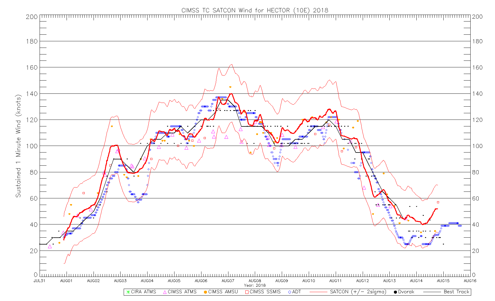
SATCON is on the rise. It's been very close to NHC's estimates for a while now too.
2 likes
Contract Meteorologist. TAMU & MSST. Fiercely authentic, one of a kind. We are all given free will, so choose a life meant to be lived. We are the Masters of our own Stories.
Opinions expressed are mine alone.
Follow me on Twitter at @1900hurricane : Read blogs at https://1900hurricane.wordpress.com/
Opinions expressed are mine alone.
Follow me on Twitter at @1900hurricane : Read blogs at https://1900hurricane.wordpress.com/
-
Yellow Evan
- Professional-Met
- Posts: 16232
- Age: 27
- Joined: Fri Jul 15, 2011 12:48 pm
- Location: Henderson, Nevada/Honolulu, HI
- Contact:

-
xtyphooncyclonex

- Category 5
- Posts: 3891
- Age: 24
- Joined: Sat Dec 08, 2012 9:07 am
- Location: Cebu City
- Contact:
Re: EPAC: HECTOR - Hurricane
latest GFS (18z) and ECMWF (12z) runs much further south and west after crossing the IDL and perhaps the GFS expects this to reach as far west as Japan (?)
Last edited by xtyphooncyclonex on Sun Aug 05, 2018 6:07 pm, edited 1 time in total.
0 likes
REMINDER: My opinions that I, or any other NON Pro-Met in this forum, are unofficial. Please do not take my opinions as an official forecast and warning. I am NOT a meteorologist. Following my forecasts blindly may lead to false alarm, danger and risk if official forecasts from agencies are ignored.
Who is online
Users browsing this forum: No registered users and 16 guests