WPAC: HECTOR - Post-Tropical

Moderator: S2k Moderators

Message
Author
User avatar
Yellow Evan
Professional-Met
Professional-Met
Posts: 16143
Age: 27
Joined: Fri Jul 15, 2011 12:48 pm
Location: Henderson, Nevada/Honolulu, HI
Contact:

Re: EPAC: HECTOR - Hurricane

#521 Postby Yellow Evan » Sun Aug 05, 2018 7:18 pm

xtyphooncyclonex wrote:More ACE than forecast. I bet it's going to reach 40-45 before Saturday. I'm now doubting the intensity forecast. This was supposed to weaken to about a cat 2-3 by now but it's doing the practical opposite.


NHC has been hugging SHIPS/LGEM which is absolutely clueless with these types of systems. This should be a major for most of its lifetime in the CPAC, if not all of it.
3 likes   

Eric Webb

Re: EPAC: HECTOR - Hurricane

#522 Postby Eric Webb » Sun Aug 05, 2018 7:22 pm

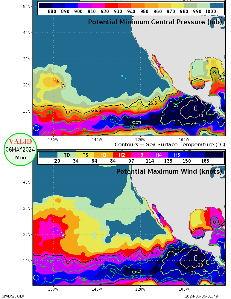
Hector is certainly in the ballpark of its theoretical MPI atm, don't see much reason why a small annular-ish TC with a well established inner core and light shear should struggle too much against dry/stable air, the slightly cooler SSTs south of Hawaii may put a modest cap on it but a major hurricane even there seems reasonable.

Image
5 likes   

User avatar
1900hurricane
Category 5
Category 5
Posts: 6059
Age: 34
Joined: Fri Feb 06, 2015 12:04 pm
Location: Houston, TX
Contact:

Re: EPAC: HECTOR - Hurricane

#523 Postby 1900hurricane » Sun Aug 05, 2018 7:23 pm

I suspect guidance, both statistical and dynamical, may be potentially underdoing intensity due to the mid level dry air that exists across much of the Central Pacific. With Hector being a small system in a low shear environment (18Z SHIPS output showed basically negligible shear through tau 120), it may be more well shielded to dry air than normal. The same 18Z SHIPS output had mid level RH dropping below 40% at times, which will certainly make a difference in expected intensities. It's something to look out for at the very least.

Image
3 likes   
Contract Meteorologist. TAMU & MSST. Fiercely authentic, one of a kind. We are all given free will, so choose a life meant to be lived. We are the Masters of our own Stories.
Opinions expressed are mine alone.

Follow me on Twitter at @1900hurricane : Read blogs at https://1900hurricane.wordpress.com/

User avatar
NotSparta
Professional-Met
Professional-Met
Posts: 1669
Age: 23
Joined: Fri Aug 18, 2017 8:24 am
Location: Naples, FL
Contact:

Re: EPAC: HECTOR - Hurricane

#524 Postby NotSparta » Sun Aug 05, 2018 7:24 pm

Eric Webb wrote:"Satellite data indicate that the hurricane has continued to strengthen during the past 6 h, and the initial intensity has increased to at least 120 kt."
NHC essentially thinks Hector is no weaker than 120 KT, if Hector strengthens even a little could see them throw 125 KT at the next advisory.


Looking at the forecast, this thing could have ~35 ACE 2-3 days before it crosses the dateline, & that's if it weakens to 80kt as the forecast says. Hector has a pretty good chance at being the biggest ACE producer of 2018 so far
0 likes   
This post was probably an opinion of mine, and in no way is official. Please refer to http://www.hurricanes.gov for official tropical analysis and advisories.

My website, with lots of tropical wx graphics, including satellite and recon: http://cyclonicwx.com

User avatar
Kingarabian
S2K Supporter
S2K Supporter
Posts: 15980
Joined: Sat Aug 08, 2009 3:06 am
Location: Honolulu, Hawaii

Re: EPAC: HECTOR - Hurricane

#525 Postby Kingarabian » Sun Aug 05, 2018 7:24 pm

Too bad this 2 hour old AMSR2 pass missed half the system. But from what I can see, there's a very intense eyewall present...

Image
1 likes   
RIP Kobe Bryant

User avatar
Kingarabian
S2K Supporter
S2K Supporter
Posts: 15980
Joined: Sat Aug 08, 2009 3:06 am
Location: Honolulu, Hawaii

Re: EPAC: HECTOR - Hurricane

#526 Postby Kingarabian » Sun Aug 05, 2018 7:27 pm

[quote="Eric Webb"]Hector is certainly in the ballpark of its theoretical MPI atm, don't see much reason why a small annular-ish TC with a well established inner core and light shear should struggle too much against dry/stable air, the slightly cooler SSTs south of Hawaii may put a modest cap on it but a major hurricane even there seems reasonable.

Image[quote]

Those maps could also be conservative in regards to supported TC intensity.

Seeing some 28C popping up just east of the Big Island:
Image
0 likes   
RIP Kobe Bryant

User avatar
xtyphooncyclonex
Category 5
Category 5
Posts: 3861
Age: 23
Joined: Sat Dec 08, 2012 9:07 am
Location: Cebu City
Contact:

Re: EPAC: HECTOR - Hurricane

#527 Postby xtyphooncyclonex » Sun Aug 05, 2018 7:27 pm

NotSparta wrote:
Eric Webb wrote:"Satellite data indicate that the hurricane has continued to strengthen during the past 6 h, and the initial intensity has increased to at least 120 kt."
NHC essentially thinks Hector is no weaker than 120 KT, if Hector strengthens even a little could see them throw 125 KT at the next advisory.


Looking at the forecast, this thing could have ~35 ACE 2-3 days before it crosses the dateline, & that's if it weakens to 80kt as the forecast says. Hector has a pretty good chance at being the biggest ACE producer of 2018 so far

I'd argue it could be the biggest ACE producer of the EPAC & CPAC, not counting the West Pacific. Ioke did less than 40 before the cross to the IDL.... What's the record? (not counting the ACE after crossing)
1 likes   
REMINDER: My opinions that I, or any other NON Pro-Met in this forum, are unofficial. Please do not take my opinions as an official forecast and warning. I am NOT a meteorologist. Following my forecasts blindly may lead to false alarm, danger and risk if official forecasts from agencies are ignored.

User avatar
Kingarabian
S2K Supporter
S2K Supporter
Posts: 15980
Joined: Sat Aug 08, 2009 3:06 am
Location: Honolulu, Hawaii

Re: EPAC: HECTOR - Hurricane

#528 Postby Kingarabian » Sun Aug 05, 2018 7:28 pm

Trying to creep to T7.0...

UW - CIMSS
ADVANCED DVORAK TECHNIQUE
ADT-Version 9.0
Tropical Cyclone Intensity Algorithm

----- Current Analysis -----
Date : 05 AUG 2018 Time : 233000 UTC
Lat : 14:31:47 N Lon : 138:28:47 W


CI# /Pressure/ Vmax
6.5 / 936.6mb/127.0kt


Final T# Adj T# Raw T#
6.5 6.7 6.7

Estimated radius of max. wind based on IR : 18 km

Center Temp : +3.8C Cloud Region Temp : -71.3
1 likes   
RIP Kobe Bryant

User avatar
NotSparta
Professional-Met
Professional-Met
Posts: 1669
Age: 23
Joined: Fri Aug 18, 2017 8:24 am
Location: Naples, FL
Contact:

Re: EPAC: HECTOR - Hurricane

#529 Postby NotSparta » Sun Aug 05, 2018 7:29 pm

1900hurricane wrote:I suspect guidance, both statistical and dynamical, may be potentially underdoing intensity due to the mid level dry air that exists across much of the Central Pacific. With Hector being a small system in a low shear environment (18Z SHIPS output showed basically negligible shear through tau 120), it may be more well shielded to dry air than normal. The same 18Z SHIPS output had mid level RH dropping below 40% at times, which will certainly make a difference in expected intensities. It's something to look out for at the very least.

[img]https://i.imgur.com/HHyHlIa.png[/ig]


As Eric Webb said above, an annular hurricane will have a less difficult time w/ the dry air. Could be significantly stronger than NHC forecast for 120 tau imo
0 likes   
This post was probably an opinion of mine, and in no way is official. Please refer to http://www.hurricanes.gov for official tropical analysis and advisories.

My website, with lots of tropical wx graphics, including satellite and recon: http://cyclonicwx.com

User avatar
Kingarabian
S2K Supporter
S2K Supporter
Posts: 15980
Joined: Sat Aug 08, 2009 3:06 am
Location: Honolulu, Hawaii

Re: EPAC: HECTOR - Hurricane

#530 Postby Kingarabian » Sun Aug 05, 2018 7:33 pm

NotSparta wrote:
1900hurricane wrote:I suspect guidance, both statistical and dynamical, may be potentially underdoing intensity due to the mid level dry air that exists across much of the Central Pacific. With Hector being a small system in a low shear environment (18Z SHIPS output showed basically negligible shear through tau 120), it may be more well shielded to dry air than normal. The same 18Z SHIPS output had mid level RH dropping below 40% at times, which will certainly make a difference in expected intensities. It's something to look out for at the very least.

[img]https://i.imgur.com/HHyHlIa.png[/ig]


As Eric Webb said above, an annular hurricane will have a less difficult time w/ the dry air. Could be significantly stronger than NHC forecast for 120 tau imo


I doubt dry air will affect it as much since it's practically annular, but at these intensities (close to cat.5), conditions need to be pristine to maintain them.
1 likes   
RIP Kobe Bryant

User avatar
Ntxw
Storm2k Moderator
Storm2k Moderator
Posts: 22785
Joined: Wed Oct 21, 2009 6:34 pm
Location: DFW, Texas

Re: EPAC: HECTOR - Hurricane

#531 Postby Ntxw » Sun Aug 05, 2018 7:34 pm

I suspect he is deserving of honorable mention in "Top hurricane sat photos of all time..." thread.

Image
11 likes   
The above post and any post by Ntxw is NOT an official forecast and should not be used as such. It is just the opinion of the poster and may or may not be backed by sound meteorological data. It is NOT endorsed by any professional institution including Storm2k. For official information, please refer to NWS products.

  Help support Storm2K!
Help Support Storm2K

User avatar
Kingarabian
S2K Supporter
S2K Supporter
Posts: 15980
Joined: Sat Aug 08, 2009 3:06 am
Location: Honolulu, Hawaii

Re: EPAC: HECTOR - Hurricane

#532 Postby Kingarabian » Sun Aug 05, 2018 7:38 pm

Ntxw wrote:[img]http://i68.tinypic.com/16bzr4o.png[img]


Who knows really, but this is close to a cat.5 or probably is one. Very very impressive presentation, the best we've seen in the EPAC for a long while.
0 likes   
RIP Kobe Bryant

CrazyC83
Professional-Met
Professional-Met
Posts: 34002
Joined: Tue Mar 07, 2006 11:57 pm
Location: Deep South, for the first time!

Re: EPAC: HECTOR - Hurricane

#533 Postby CrazyC83 » Sun Aug 05, 2018 7:39 pm

With the new data, I would estimate the intensity at 130 kt. The T6.7 estimate seems fairly reasonable.
3 likes   

Eric Webb

Re: EPAC: HECTOR - Hurricane

#534 Postby Eric Webb » Sun Aug 05, 2018 7:39 pm

I'm certainly very excited to see what the Hurricane Hunter plane will find with Hector tomorrow, wouldn't be surprised if they discovered anything from a mid grade category 3 to a category 5 hurricane, a 15-20 KT error in satellite intensity estimates is pretty standard.
5 likes   

User avatar
1900hurricane
Category 5
Category 5
Posts: 6059
Age: 34
Joined: Fri Feb 06, 2015 12:04 pm
Location: Houston, TX
Contact:

Re: EPAC: HECTOR - Hurricane

#535 Postby 1900hurricane » Sun Aug 05, 2018 7:40 pm

xtyphooncyclonex wrote:
NotSparta wrote:
Eric Webb wrote:"Satellite data indicate that the hurricane has continued to strengthen during the past 6 h, and the initial intensity has increased to at least 120 kt."
NHC essentially thinks Hector is no weaker than 120 KT, if Hector strengthens even a little could see them throw 125 KT at the next advisory.


Looking at the forecast, this thing could have ~35 ACE 2-3 days before it crosses the dateline, & that's if it weakens to 80kt as the forecast says. Hector has a pretty good chance at being the biggest ACE producer of 2018 so far

I'd argue it could be the biggest ACE producer of the EPAC & CPAC, not counting the West Pacific. Ioke did less than 40 before the cross to the IDL.... What's the record? (not counting the ACE after crossing)

John '94 technically holds the record for Pacific ACE east of the International Date Line with 53.9775 units, but there is a catch with that number. John crossed the International Date Line and then returned. 51.08 of it was accrued prior to the first cross, which actually isn't the most in one consecutive stint. That goes to Kevin '91, which accumulated 52.1425 units over the course of its life.
4 likes   
Contract Meteorologist. TAMU & MSST. Fiercely authentic, one of a kind. We are all given free will, so choose a life meant to be lived. We are the Masters of our own Stories.
Opinions expressed are mine alone.

Follow me on Twitter at @1900hurricane : Read blogs at https://1900hurricane.wordpress.com/

User avatar
Dylan
Professional-Met
Professional-Met
Posts: 338
Age: 30
Joined: Mon May 31, 2010 9:50 am
Location: New Orleans, LA

Re: EPAC: HECTOR - Hurricane

#536 Postby Dylan » Sun Aug 05, 2018 7:40 pm

4 likes   
Georges('98), Allison('01), Isidore('02), Lili('02), Frances('04) Ivan('04), Cindy('05), Katrina('05), Rita('05), Gustav('08), Isaac('12), Matthew('16), Harvey('17), Irma('17), Nate ('17), Ida ('21).

User avatar
Kingarabian
S2K Supporter
S2K Supporter
Posts: 15980
Joined: Sat Aug 08, 2009 3:06 am
Location: Honolulu, Hawaii

Re: EPAC: HECTOR - Hurricane

#537 Postby Kingarabian » Sun Aug 05, 2018 7:50 pm

SAB kept it at 6.0.

Have to keep a close eye on the track now to see how well Hector is following it:
Image
0 likes   
RIP Kobe Bryant

User avatar
xtyphooncyclonex
Category 5
Category 5
Posts: 3861
Age: 23
Joined: Sat Dec 08, 2012 9:07 am
Location: Cebu City
Contact:

Re: EPAC: HECTOR - Hurricane

#538 Postby xtyphooncyclonex » Sun Aug 05, 2018 7:51 pm

Ntxw wrote:I suspect he is deserving of honorable mention in "Top hurricane sat photos of all time..." thread.

Image

"Well, so much for the shear."
6 likes   
REMINDER: My opinions that I, or any other NON Pro-Met in this forum, are unofficial. Please do not take my opinions as an official forecast and warning. I am NOT a meteorologist. Following my forecasts blindly may lead to false alarm, danger and risk if official forecasts from agencies are ignored.

CrazyC83
Professional-Met
Professional-Met
Posts: 34002
Joined: Tue Mar 07, 2006 11:57 pm
Location: Deep South, for the first time!

Re: EPAC: HECTOR - Hurricane

#539 Postby CrazyC83 » Sun Aug 05, 2018 7:51 pm

Kingarabian wrote:
Eric Webb wrote:Hector is certainly in the ballpark of its theoretical MPI atm, don't see much reason why a small annular-ish TC with a well established inner core and light shear should struggle too much against dry/stable air, the slightly cooler SSTs south of Hawaii may put a modest cap on it but a major hurricane even there seems reasonable.
Seeing some 28C popping up just east of the Big Island:
Image


That's a real breeding ground for intensification if Hector stays low and gets into that 30, 31C water closer to the dateline. That could EASILY support a strong cat 5.
5 likes   

User avatar
Kingarabian
S2K Supporter
S2K Supporter
Posts: 15980
Joined: Sat Aug 08, 2009 3:06 am
Location: Honolulu, Hawaii

Re: EPAC: HECTOR - Hurricane

#540 Postby Kingarabian » Sun Aug 05, 2018 7:51 pm

A few SSMIS passes will be in soon. Hope they don't miss the core.
1 likes   
RIP Kobe Bryant


Return to “2018”

Who is online

Users browsing this forum: No registered users and 0 guests