WPAC: HECTOR - Post-Tropical

Moderator: S2k Moderators

Message
Author
User avatar
cycloneye
Admin
Admin
Posts: 145303
Age: 68
Joined: Thu Oct 10, 2002 10:54 am
Location: San Juan, Puerto Rico

Re: EPAC: HECTOR - Hurricane

#561 Postby cycloneye » Sun Aug 05, 2018 9:34 pm

Hurricane Hector Discussion Number 23
NWS National Hurricane Center Miami FL EP102018
800 PM PDT Sun Aug 05 2018

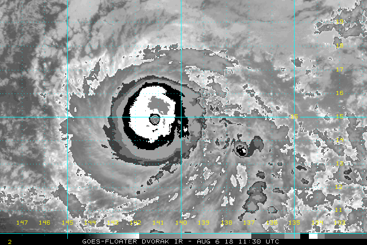
Hector has changed little in organization since the previous special
advisory, and the various satellite intensity estimates are in the
115-125 kt range. Based on these data, the initial intensity
remains 120 kt. The forecast track takes the cyclone over an area
of cooler water between 24-60 h and into a drier air mass after 60
h, and based on this the intensity forecast continues the trend of
the previous forecast in showing a gradual weakening through the
forecast period. There are two caveats to this forecast, however.
The first is that Hector will move over warmer water after 60 h, and
the HWRF amd LGEM models are suggesting re-intensification could
occur from 96-120 h. Second, the environment of light easterly
shear and moderate sea surface temperatures could allow Hector to
evolve into an annular hurricane, which would cause it to stay more
intense than the guidance and the official forecast are indicating.

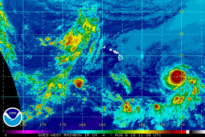
The hurricane is starting a northward nudge that the track models
have been advertising, and the initial motion is now 280/12. The
subtropical ridge to the north of Hector should steer it
west-northwestward with an increase in forward speed for the next
24-36 h, followed by a more westerly motion to the south of the
Hawaiian Islands for the remainder of the forecast period. Track
guidance has become less divergent since yesterday, and the new
forecast track lies near the center of the track guidance envelope.

While the official forecast track continues to lie south of the
Hawaiian Islands, only a slight deviation to the north of the
forecast track would significantly increase potential impacts on the
Hawaiian Islands. Now is a good time for everyone in the Hawaiian
Islands to ensure that they have their hurricane plan in place. For
additional information on any potential local impacts from Hector in
Hawaii, please refer to products issued by the NWS Weather Forecast
Office in Honolulu at: http://www.prh.noaa.gov/hnl .

This is the last advisory issued by the National Hurricane Center on
Hector. Future information on this system can be found in Public
Advisories issued by the Central Pacific Hurricane Center beginning
at 11 PM HST, under AWIPS header HFOTCPCP1, WMO header WTPA31 PHFO,
and on the web at http://www.prh.noaa.gov/cphc .


FORECAST POSITIONS AND MAX WINDS

INIT 06/0300Z 14.7N 139.2W 120 KT 140 MPH
12H 06/1200Z 15.1N 141.1W 120 KT 140 MPH
24H 07/0000Z 15.8N 144.1W 115 KT 130 MPH
36H 07/1200Z 16.2N 147.0W 105 KT 120 MPH
48H 08/0000Z 16.6N 150.3W 95 KT 110 MPH
72H 09/0000Z 17.0N 156.5W 90 KT 105 MPH
96H 10/0000Z 17.0N 162.5W 85 KT 100 MPH
120H 11/0000Z 17.5N 168.0W 85 KT 100 MPH

$$
Forecaster Beven
0 likes   
Visit the Caribbean-Central America Weather Thread where you can find at first post web cams,radars
and observations from Caribbean basin members Click Here

User avatar
Hypercane_Kyle
Category 5
Category 5
Posts: 3352
Joined: Sat Mar 07, 2015 7:58 pm
Location: Cape Canaveral, FL

Re: EPAC: HECTOR - Hurricane

#562 Postby Hypercane_Kyle » Sun Aug 05, 2018 10:21 pm

Has a hurricane from the EPAC ever made it all the way to 140E before? Could be a real possibility with Hector.
1 likes   
My posts are my own personal opinion, defer to the National Hurricane Center (NHC) and other NOAA products for decision making during hurricane season.

User avatar
1900hurricane
Category 5
Category 5
Posts: 6059
Age: 34
Joined: Fri Feb 06, 2015 12:04 pm
Location: Houston, TX
Contact:

Re: EPAC: HECTOR - Hurricane

#563 Postby 1900hurricane » Sun Aug 05, 2018 10:25 pm

Hypercane_Kyle wrote:Has a hurricane from the EPAC ever made it all the way to 140E before? Could be a real possibility with Hector.

A couple of CPac systems have, but I don't think one that came from the EPac proper ever has.
1 likes   
Contract Meteorologist. TAMU & MSST. Fiercely authentic, one of a kind. We are all given free will, so choose a life meant to be lived. We are the Masters of our own Stories.
Opinions expressed are mine alone.

Follow me on Twitter at @1900hurricane : Read blogs at https://1900hurricane.wordpress.com/

User avatar
xtyphooncyclonex
Category 5
Category 5
Posts: 3861
Age: 23
Joined: Sat Dec 08, 2012 9:07 am
Location: Cebu City
Contact:

Re: EPAC: HECTOR - Hurricane

#564 Postby xtyphooncyclonex » Sun Aug 05, 2018 10:29 pm

SEASON_CANCELED wrote:media is way overhyping this one. These storms get shredded up before they get close to the big island. Its very rare they make it, they have to be moving fast

Apparently, you haven't been tracking this storm :lol:
2 likes   
REMINDER: My opinions that I, or any other NON Pro-Met in this forum, are unofficial. Please do not take my opinions as an official forecast and warning. I am NOT a meteorologist. Following my forecasts blindly may lead to false alarm, danger and risk if official forecasts from agencies are ignored.

User avatar
Kingarabian
S2K Supporter
S2K Supporter
Posts: 15980
Joined: Sat Aug 08, 2009 3:06 am
Location: Honolulu, Hawaii

Re: EPAC: HECTOR - Hurricane

#565 Postby Kingarabian » Sun Aug 05, 2018 11:25 pm

00z GFS with the GIV data keeps it south of the islands.
1 likes   
RIP Kobe Bryant

CrazyC83
Professional-Met
Professional-Met
Posts: 34002
Joined: Tue Mar 07, 2006 11:57 pm
Location: Deep South, for the first time!

Re: EPAC: HECTOR - Hurricane

#566 Postby CrazyC83 » Sun Aug 05, 2018 11:45 pm

Dry air looks to be the limiting factor down the line. If it stays south though, it may miss most of that dry air...
0 likes   

Twisted-core

Re: EPAC: HECTOR - Hurricane

#567 Postby Twisted-core » Sun Aug 05, 2018 11:59 pm

Navgem still thinks there will be weather for the islands with Hector.
Image
https://imgur.com/FRnxttg

Image
https://imgur.com/B5ElB1u
0 likes   

User avatar
Dylan
Professional-Met
Professional-Met
Posts: 338
Age: 30
Joined: Mon May 31, 2010 9:50 am
Location: New Orleans, LA

Re: EPAC: HECTOR - Hurricane

#568 Postby Dylan » Mon Aug 06, 2018 12:44 am

CrazyC83 wrote:Dry air looks to be the limiting factor down the line. If it stays south though, it may miss most of that dry air...


If Hector goes fully annular it won’t matter at all. Atmospheric conditions are prime for it to do so. We’ll see. Only have another 10-20 days to watch it!
4 likes   
Georges('98), Allison('01), Isidore('02), Lili('02), Frances('04) Ivan('04), Cindy('05), Katrina('05), Rita('05), Gustav('08), Isaac('12), Matthew('16), Harvey('17), Irma('17), Nate ('17), Ida ('21).

User avatar
xtyphooncyclonex
Category 5
Category 5
Posts: 3861
Age: 23
Joined: Sat Dec 08, 2012 9:07 am
Location: Cebu City
Contact:

Re: EPAC: HECTOR - Hurricane

#569 Postby xtyphooncyclonex » Mon Aug 06, 2018 1:35 am

Much stronger and further west on the latest ECMWF run. Still rolling at TAU 144. Ridge seems to be more intact as well, starts to rebuild as it nears the IDL
1 likes   
REMINDER: My opinions that I, or any other NON Pro-Met in this forum, are unofficial. Please do not take my opinions as an official forecast and warning. I am NOT a meteorologist. Following my forecasts blindly may lead to false alarm, danger and risk if official forecasts from agencies are ignored.

USTropics
Professional-Met
Professional-Met
Posts: 2651
Joined: Sun Aug 12, 2007 3:45 am
Location: Florida State University

Re: EPAC: HECTOR - Hurricane

#570 Postby USTropics » Mon Aug 06, 2018 2:34 am

GFS and ECMWF continue to agree on Hector going for a lengthy stroll through the Pacific:

Image

Image
1 likes   

Twisted-core

Re: EPAC: HECTOR - Hurricane

#571 Postby Twisted-core » Mon Aug 06, 2018 3:20 am

USING ADT RMW OF 7.8
R34 R50 R64
NE : 120.0 60.0 40.0
SE : 90.0 50.0 25.0
SW : 85.0 45.0 20.0
NW : 120.0 60.0 40.0
Storm Info :
-Speed= 13.3 kts
-Direction= 281.2
-Vmax= 127.0 kts
-Method= 2


As far i know noaa declares a cat5 @130kts these days or did.
was @
2018AUG06 060000 6.6 934.2 129.6 6.3 6.5 6.5 NO LIMIT ON OFF OFF OFF -7.16 -70.89 EYE 13 IR 47.5 14.77 139.86 ARCHER GOES15 18.2


2018AUG06 073000 6.5 936.5 127.0 6.4 6.7 6.7 NO LIMIT ON OFF OFF OFF 3.24 -71.27 EYE 14 IR 47.5 14.77 140.28 ARCHER GOES15 18.3
1 likes   

User avatar
Kingarabian
S2K Supporter
S2K Supporter
Posts: 15980
Joined: Sat Aug 08, 2009 3:06 am
Location: Honolulu, Hawaii

Re: EPAC: HECTOR - Hurricane

#572 Postby Kingarabian » Mon Aug 06, 2018 3:32 am

UW - CIMSS
ADVANCED DVORAK TECHNIQUE
ADT-Version 9.0
Tropical Cyclone Intensity Algorithm

----- Current Analysis -----
Date : 06 AUG 2018 Time : 073000 UTC
Lat : 14:46:12 N Lon : 140:16:47 W


CI# /Pressure/ Vmax
6.5 / 936.5mb/127.0kt


Final T# Adj T# Raw T#
6.4 6.7 6.7
0 likes   
RIP Kobe Bryant

User avatar
Kingarabian
S2K Supporter
S2K Supporter
Posts: 15980
Joined: Sat Aug 08, 2009 3:06 am
Location: Honolulu, Hawaii

Re: EPAC: HECTOR - Hurricane

#573 Postby Kingarabian » Mon Aug 06, 2018 3:43 am

Image

Intensifying again.
0 likes   
RIP Kobe Bryant

User avatar
WAcyclone
Category 1
Category 1
Posts: 352
Joined: Sat Jul 01, 2017 1:56 pm
Location: Perth, Western Australia

Re: EPAC: HECTOR - Hurricane

#574 Postby WAcyclone » Mon Aug 06, 2018 4:01 am

Some 300 m-resolution Sentinel-3 images of Hector from 1715z yesterday:

Image

Maximum resolution:

Image
7 likes   

User avatar
xtyphooncyclonex
Category 5
Category 5
Posts: 3861
Age: 23
Joined: Sat Dec 08, 2012 9:07 am
Location: Cebu City
Contact:

Re: EPAC: HECTOR - Hurricane

#575 Postby xtyphooncyclonex » Mon Aug 06, 2018 4:16 am

Impressive symmetry.

Image
2 likes   
REMINDER: My opinions that I, or any other NON Pro-Met in this forum, are unofficial. Please do not take my opinions as an official forecast and warning. I am NOT a meteorologist. Following my forecasts blindly may lead to false alarm, danger and risk if official forecasts from agencies are ignored.

Twisted-core

Re: EPAC: HECTOR - Hurricane

#576 Postby Twisted-core » Mon Aug 06, 2018 4:21 am

00z EPS thinks no easy big ace for the wpac
Image
https://imgur.com/MWCupU5


normal ens :darrow: medium range.
Image
https://imgur.com/YrW3Hti
0 likes   

Sciencerocks
Category 5
Category 5
Posts: 9155
Age: 39
Joined: Thu Jul 06, 2017 1:51 am

Re: EPAC: HECTOR - Hurricane

#577 Postby Sciencerocks » Mon Aug 06, 2018 4:36 am

Looks around 130 knots.
1 likes   

User avatar
cycloneye
Admin
Admin
Posts: 145303
Age: 68
Joined: Thu Oct 10, 2002 10:54 am
Location: San Juan, Puerto Rico

Re: EPAC: HECTOR - Hurricane

#578 Postby cycloneye » Mon Aug 06, 2018 5:12 am

Hurricane Hector Discussion Number 24
NWS Central Pacific Hurricane Center Honolulu HI EP102018
1100 PM HST Sun Aug 05 2018

The satellite presentation of Hurricane Hector remains impressive
this evening, with a well defined eye surrounded by a large ring of
-70 to -80 degree Celsius cloud tops. The latest subjective Dvorak
current intensity estimates from PHFO and SAB came in at 6.0 (115
knots), while the Advanced Dvorak technique yielded 6.6 (130
knots). Given that Hector's satellite presentation has changed
little since the previous advisory, the initial intensity is held at
120 knots which is more or less a blend of the available intensity
estimates. Hector has continued to track westward and has picked up
a little speed since the previous advisory. The initial motion of
Hector is set at 280/13 kt.

The latest model guidance remains tightly clustered and brings
Hector just north of due west over the next 36 to 48 hours due to a
weakness in the subtropical ridge just to the northeast of the
Hawaiian islands. Beyond 48 hours, the subtropical ridge is
forecast to build to the north of the Hawaiian Island chain, and
this should result in the track of Hector moving due westward from
48 to 120 hours. The new official forecast track is very close to
the model consensus and nearly identical to the previous official
forecast.

Hector will remain in favorable low shear environment through the
forecast period, but there are some factors that should lead to
gradual weakening beyond 24 hours. The hurricane will be traveling
over marginal sea surface temperatures around 27C for the next few
days, before the SSTs increase to around 28C to the south of the
Hawaiian Islands. Additionally and likely more importantly, very
dry mid-level air will begin to surround the storm Monday night,
and this is expected to lead to gradual weakening of the system
from Monday night through Wednesday. The intensity of the system is
then expected to level off Wednesday night through Friday as it
encounters the higher SSTs. The intensity forecast is very close
to the previous forecast with some additional weight given to the
dynamical models which have been performing better with this system
than the statistical guidance.

While the official forecast track continues to lie to the south of
the Hawaiian islands, only a slight deviation to the north of the
forecast track would significantly increase potential impacts to
the state of Hawaii. Now is a good time for everyone in the
Hawaiian Islands to ensure that they have their hurricane plan in
place. For additional information on any potential impacts from
Hector in Hawaii, please refer to products issued by the NWS Weather
Forecast Office here in Honolulu at: http://www.prh.noaa.gov/hnl .


FORECAST POSITIONS AND MAX WINDS

INIT 06/0900Z 14.9N 140.6W 120 KT 140 MPH
12H 06/1800Z 15.3N 142.6W 120 KT 140 MPH
24H 07/0600Z 15.8N 145.4W 115 KT 130 MPH
36H 07/1800Z 16.3N 148.5W 105 KT 120 MPH
48H 08/0600Z 16.7N 151.7W 100 KT 115 MPH
72H 09/0600Z 16.8N 158.0W 90 KT 105 MPH
96H 10/0600Z 17.0N 164.0W 85 KT 100 MPH
120H 11/0600Z 17.6N 169.5W 85 KT 100 MPH

$$
Forecaster Jelsema
0 likes   
Visit the Caribbean-Central America Weather Thread where you can find at first post web cams,radars
and observations from Caribbean basin members Click Here

User avatar
xtyphooncyclonex
Category 5
Category 5
Posts: 3861
Age: 23
Joined: Sat Dec 08, 2012 9:07 am
Location: Cebu City
Contact:

CPAC: HECTOR - Hurricane

#579 Postby xtyphooncyclonex » Mon Aug 06, 2018 6:14 am

Clearly intensifying. Defying previous forecasts depicting weakening. I'm now thinking this would be at least a major hurricane throughout its entire journey in the CPAC before crossing the even more favorable west Pacific.

Image
0 likes   
REMINDER: My opinions that I, or any other NON Pro-Met in this forum, are unofficial. Please do not take my opinions as an official forecast and warning. I am NOT a meteorologist. Following my forecasts blindly may lead to false alarm, danger and risk if official forecasts from agencies are ignored.

User avatar
Ntxw
Storm2k Moderator
Storm2k Moderator
Posts: 22784
Joined: Wed Oct 21, 2009 6:34 pm
Location: DFW, Texas

Re: CPAC: HECTOR - Hurricane

#580 Postby Ntxw » Mon Aug 06, 2018 7:13 am

Will recon find a Cat 5 today if he holds?

UW - CIMSS
ADVANCED DVORAK TECHNIQUE
ADT-Version 9.0
Tropical Cyclone Intensity Algorithm

----- Current Analysis -----
Date : 06 AUG 2018 Time : 110000 UTC
Lat : 14:49:47 N Lon : 141:03:00 W


CI# /Pressure/ Vmax
6.8 / 929.4mb/134.8kt


Final T# Adj T# Raw T#
6.8 6.8 6.8

Estimated radius of max. wind based on IR : 16 km

Center Temp : +7.4C Cloud Region Temp : -71.7C

Scene Type : EYE


Image

Image
3 likes   
The above post and any post by Ntxw is NOT an official forecast and should not be used as such. It is just the opinion of the poster and may or may not be backed by sound meteorological data. It is NOT endorsed by any professional institution including Storm2k. For official information, please refer to NWS products.

  Help support Storm2K!
Help Support Storm2K


Return to “2018”

Who is online

Users browsing this forum: No registered users and 3 guests