
WPAC: HECTOR - Post-Tropical
Moderator: S2k Moderators
-
NotSparta

- Professional-Met

- Posts: 1677
- Age: 24
- Joined: Fri Aug 18, 2017 8:24 am
- Location: Naples, FL
- Contact:
Re: CPAC: HECTOR - Hurricane
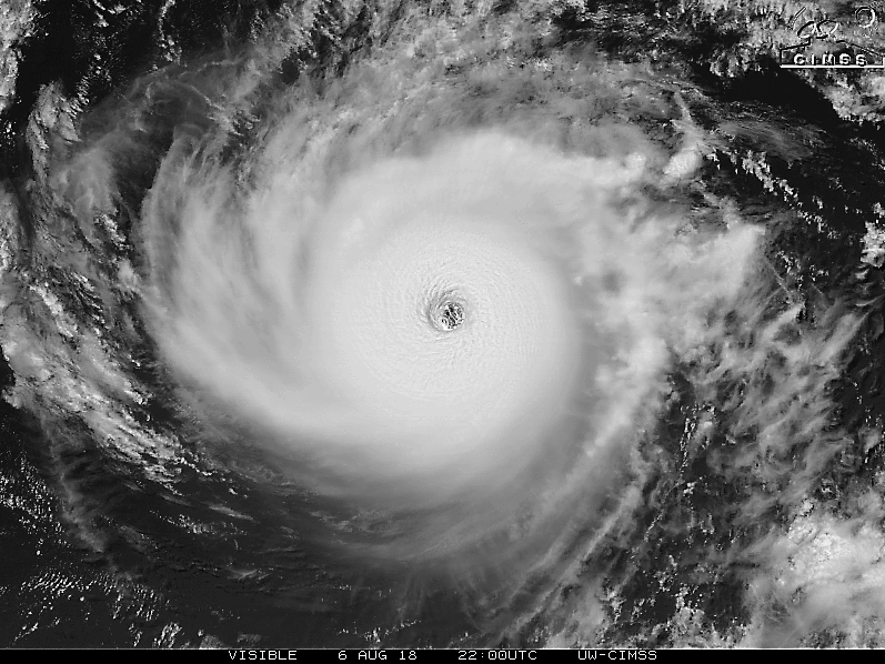
This feature sure looks interesting
3 likes
This post was probably an opinion of mine, and in no way is official. Please refer to http://www.hurricanes.gov for official tropical analysis and advisories.
My website, with lots of tropical wx graphics, including satellite and recon: http://cyclonicwx.com
My website, with lots of tropical wx graphics, including satellite and recon: http://cyclonicwx.com
-
Kingarabian

- S2K Supporter

- Posts: 16353
- Joined: Sat Aug 08, 2009 3:06 am
- Location: Honolulu, Hawaii
Re: CPAC: HECTOR - Hurricane
NotSparta wrote:This feature sure looks interesting
[img]https://i.imgur.com/u2tHGIo.jpg[mg]
Core is well shielded from dry air.
2 likes
RIP Kobe Bryant
-
Eric Webb
Re: CPAC: HECTOR - Hurricane
I highly recommend everyone to watch this 15 minute talk on "Upper-Tropospheric Static Stability in Tropical Cyclones: Observations and Modeling".
This explains why Hector's eye has been warming over the course of the day, the storm is actually mixing in warmer and drier air from the stratosphere into its eye and progressively eradicating the inversion near the tropopause, this certainly can provide a positive feedback mechanism for TCs like Hector that are already intense to continuing intensifying.
https://twitter.com/pppapin/status/1026602798169747456
7 likes
-
Kingarabian
- S2K Supporter
- Posts: 16353
- Joined: Sat Aug 08, 2009 3:06 am
- Location: Honolulu, Hawaii
Re: CPAC: HECTOR - Hurricane
Eric Webb wrote:I highly recommend everyone to watch this 15 minute talk on "Upper-Tropospheric Static Stability in Tropical Cyclones: Observations and Modeling".
This explains why Hector's eye has been warming over the course of the day, the storm is actually mixing in warmer and drier air from the stratosphere into its eye and progressively eradicating the inversion near the tropopause, this certainly can provide a positive feedback mechanism for TCs like Hector that are already intense to continuing intensifying.
[tweet]https://twitter.com/pppapin/status/1026602798169747456[tweet]
Thanks for the share. It's also interesting that we haven't seen an EWRC in some time.
1 likes
RIP Kobe Bryant
-
mrbagyo

- Category 5

- Posts: 3963
- Age: 33
- Joined: Thu Apr 12, 2012 9:18 am
- Location: 14.13N 120.98E
- Contact:
Re: CPAC: HECTOR - Hurricane
Beauty

Yeah, it's really amazing to see Hector maintaining that structure for so long and not experiencing bouts of ERC.
Kingarabian wrote:It's also interesting that we haven't seen an EWRC in some time.
Yeah, it's really amazing to see Hector maintaining that structure for so long and not experiencing bouts of ERC.
8 likes
The posts in this forum are NOT official forecast and should not be used as such. They are just the opinion of the poster and may or may not be backed by sound meteorological data. They are NOT endorsed by any professional institution or storm2k.org. For official information, please refer to RSMC, NHC and NWS products.


Re: CPAC: HECTOR - Hurricane
10 likes
The above post and any post by Ntxw is NOT an official forecast and should not be used as such. It is just the opinion of the poster and may or may not be backed by sound meteorological data. It is NOT endorsed by any professional institution including Storm2k. For official information, please refer to NWS products.
Help support Storm2K!

-
Eric Webb
Re: CPAC: HECTOR - Hurricane
Kingarabian wrote:Eric Webb wrote:I highly recommend everyone to watch this 15 minute talk on "Upper-Tropospheric Static Stability in Tropical Cyclones: Observations and Modeling".
This explains why Hector's eye has been warming over the course of the day, the storm is actually mixing in warmer and drier air from the stratosphere into its eye and progressively eradicating the inversion near the tropopause, this certainly can provide a positive feedback mechanism for TCs like Hector that are already intense to continuing intensifying.
[tweet]https://twitter.com/pppapin/status/1026602798169747456[tweet]
Thanks for the share. It's also interesting that we haven't seen an EWRC in some time.
Environments w/ gently sloping large-scale SST gradients as is the case w/ Hector, limits the development of instability gradients and asymmetries across the breadth of a TC that can cause one sector of the cyclone to become overloaded w/ convection, etc. Lukewarm SSTs <28.5C also help too wherein the PBL may be only modestly unstable such that convection isn't generated as "spontaneously" and the release of CAPE is accompanied by a lower moist static energy budget. Essentially what I'm saying here when I refer to the moist static energy budget is the theoretical "ceiling" for total integrated water vapor in the troposphere is lower when the temperature is lower, we know this from the Clasius-Clapyeron relation where saturation vapor pressure increases exponentially in conjunction with increasing temperature (warmer air not only holds more moisture, but the difference in moisture per degree of change in temperature gets larger at higher temperatures! (and vis versa)). Drier environments like the one Hector is in have been found by one of my professors at NCSU to limit convection outside the inner core and cause the size of tropical cyclones to shrink, both of these are true in Hector's case. Less convection outside the inner core also means the development of spiral bands that's associated w/ a stereotypical hurricane are also limited, therefore drier air in the large-scale environment may also aid in the development of an annular hurricane! Some studies have also pointed to ice nucleation in the upper troposphere as a necessary prerequisite for secondary eyewall development. All I'm really trying to do here is provide some reasoning as to why things like gently sloping SSTs, lukewarm SSTs, and drier environmental air which have been discussed both here, on my twitter account, and in NHC discussions are conducive to annular hurricanes, the influence of light easterly shear still eludes me, at least for now.
Here's the link to the study on Environmental Humidity and TC size from one of my professors at NCSU (Gary Lackmann)
https://journals.ametsoc.org/doi/abs/10.1175/2009MWR2679.1
10 likes
-
1900hurricane

- Category 5
- Posts: 6063
- Age: 34
- Joined: Fri Feb 06, 2015 12:04 pm
- Location: Houston, TX
- Contact:
Re: CPAC: HECTOR - Hurricane
Structure is still looking rather stable.

Last edited by 1900hurricane on Mon Aug 06, 2018 7:44 pm, edited 1 time in total.
3 likes
Contract Meteorologist. TAMU & MSST. Fiercely authentic, one of a kind. We are all given free will, so choose a life meant to be lived. We are the Masters of our own Stories.
Opinions expressed are mine alone.
Follow me on Twitter at @1900hurricane : Read blogs at https://1900hurricane.wordpress.com/
Opinions expressed are mine alone.
Follow me on Twitter at @1900hurricane : Read blogs at https://1900hurricane.wordpress.com/
-
Yellow Evan

- Professional-Met
- Posts: 16232
- Age: 27
- Joined: Fri Jul 15, 2011 12:48 pm
- Location: Henderson, Nevada/Honolulu, HI
- Contact:
Re: CPAC: HECTOR - Hurricane
WTPA31 PHFO 070000
TCPCP1
BULLETIN
Hurricane Hector Intermediate Advisory Number 26A
NWS Central Pacific Hurricane Center Honolulu HI EP102018
200 PM HST Mon Aug 06 2018
...STRONG CATEGORY FOUR HURRICANE HECTOR CONTINUES TO MOVE
WESTWARD ACROSS THE CENTRAL PACIFIC...
SUMMARY OF 200 PM HST...0000 UTC...INFORMATION
----------------------------------------------
LOCATION...15.5N 143.9W
ABOUT 800 MI...1290 KM ESE OF HILO HAWAII
ABOUT 1000 MI...1610 KM ESE OF HONOLULU HAWAII
MAXIMUM SUSTAINED WINDS...155 MPH...250 KM/H
PRESENT MOVEMENT...W OR 280 DEGREES AT 16 MPH...26 KM/H
MINIMUM CENTRAL PRESSURE...936 MB...27.64 INCHES
WATCHES AND WARNINGS
--------------------
CHANGES WITH THIS ADVISORY:
None.
SUMMARY OF WATCHES AND WARNINGS IN EFFECT:
* A Tropical Storm Watch is in effect for...
* Hawaii County
A Tropical Storm Watch means that tropical storm conditions are
possible within the watch area within 48 hours.
Interests elsewhere in the Hawaiian Islands should monitor the
progress of Hector.
For storm information specific to your area, please monitor
products issued by the National Weather Service office in
Honolulu, Hawaii.
DISCUSSION AND OUTLOOK
----------------------
At 200 PM HST (0000 UTC), the center of Hurricane Hector was located
near latitude 15.5 North, longitude 143.9 West. Hector is moving
toward the west near 16 mph (26 km/h). This general motion is
expected to continue for the next couple of days. On the forecast
track, Hector is expected to pass roughly 150 miles south of the Big
Island of Hawaii on Wednesday.
Maximum sustained winds are near 155 mph (250 km/h) with higher
gusts. Hector is a category 4 hurricane on the Saffir-Simpson
Hurricane Wind Scale. Some weakening is forecast during the next 48
hours, though Hector is expected to remain a major hurricane.
Hurricane-force winds extend outward up to 35 miles (55 km) from
the center and tropical-storm-force winds extend outward up to 105
miles (165 km).
The estimated minimum central pressure is 936 mb (27.64 inches).
HAZARDS AFFECTING LAND
----------------------
SURF: Swells generated by Hector are expected to reach southeast
and east facing shores of the Big Island and eastern Maui during
the next day, likely becoming large by late Tuesday and Wednesday.
WIND: Tropical storm force winds are possible across Hawaii
County on Wednesday.
NEXT ADVISORY
-------------
Next complete advisory at 500 PM HST.
$$
Forecaster Wroe
0 likes
-
Kingarabian
- S2K Supporter
- Posts: 16353
- Joined: Sat Aug 08, 2009 3:06 am
- Location: Honolulu, Hawaii

-
Eric Webb
Re: CPAC: HECTOR - Hurricane
Kingarabian wrote:Core untouched:
That's definitely a prominent spiral band in the southern semicircle, not surprisingly this is immediately adjacent to the warmest SSTs relative to the cyclone, I'm curious to see if it'll wrap around the entire cyclone or disintegrate entirely, I'm really not sure which will happen here because the air is so dry and the SSTs and stability north of Hector is very marginal at best.
4 likes


-
NotSparta
- Professional-Met
- Posts: 1677
- Age: 24
- Joined: Fri Aug 18, 2017 8:24 am
- Location: Naples, FL
- Contact:
Re: CPAC: HECTOR - Hurricane
You can start to see the hurricane symbol there, another confirmation of an intense TC
0 likes
This post was probably an opinion of mine, and in no way is official. Please refer to http://www.hurricanes.gov for official tropical analysis and advisories.
My website, with lots of tropical wx graphics, including satellite and recon: http://cyclonicwx.com
My website, with lots of tropical wx graphics, including satellite and recon: http://cyclonicwx.com
-
Kingarabian
- S2K Supporter
- Posts: 16353
- Joined: Sat Aug 08, 2009 3:06 am
- Location: Honolulu, Hawaii
Re: CPAC: HECTOR - Hurricane
Long term motion is still WNW but a little off track here.

2 likes
RIP Kobe Bryant
-
Chris_in_Tampa
- Category 5
- Posts: 5101
- Age: 42
- Joined: Thu Jun 21, 2007 11:06 pm
- Location: Tampa, Florida, USA
- Contact:
Re: EPAC: HECTOR - Recon
NOAA G-IV mission through 1:07Z on Tuesday (9:07pm EDT on Monday / 3:07pm HST on Monday):

0 likes
-
Kingarabian
- S2K Supporter
- Posts: 16353
- Joined: Sat Aug 08, 2009 3:06 am
- Location: Honolulu, Hawaii

-
NotSparta
- Professional-Met
- Posts: 1677
- Age: 24
- Joined: Fri Aug 18, 2017 8:24 am
- Location: Naples, FL
- Contact:
Re: CPAC: HECTOR - Hurricane
WTPA41 PHFO 070248
TCDCP1
Hurricane Hector Discussion Number 27
NWS Central Pacific Hurricane Center Honolulu HI EP102018
500 PM HST Mon Aug 06 2018
Hector has shown little change in satellite imagery today and
remains very impressive. Continuous bursts of lightning have been
occurring within the eyewall, and the hurricane is maintaining an
annular structure. Fixes from HFO, SAB, and JTWC came in at 6.5/127
kt again, and CIMSS ADT yielded 132 kt. Given what was sampled by
morning reconnaissance aircraft and the lack of significant change
in the satellite presentation, the initial intensity will be held at
135 kt. Unfortunately, the US Air Force Reserve 53rd Weather
Reconnaissance Squadron had to cut its mission short this morning,
but the next mission will occur this evening around 0530 UTC.
The initial motion of Hector is toward the west-northwest (285
degrees) at 14 kt. Hector took on a slight northward drift today as
the deep ridge to the north weakened. The ridge will move to the
north of Hawaii on Tuesday, which should cause Hector to resume a
motion toward due west and take the hurricane just south of the
Hawaiian Islands on Wednesday. As a result, a Tropical Storm
Watch remains in effect for the Big Island of Hawaii. Aside from a
slight adjustment to the north, little change was made to the track
forecast. The forecast lies down the middle of a fairly tightly
clustered guidance suite during the next 72 hours and runs near to
just north of the TVCN. On days four and five, a gradual turn toward
the west-northwest is expected as the deep ridge to the north
weakens.
Hector is expected to remain a major hurricane during the next
couple of days. The system is in a low vertical wind shear
environment, and with nearby sea surface temperatures just over 27C,
Hector is near its maximum potential intensity according the SHIPS
guidance. There will be only minor fluctuations in sea surface
temperature during the next 72 hours and continued low vertical
wind shear, though models indicate mid level dry air affecting the
hurricane. So far, this has not had much of an effect on Hector,
leading to lower confidence in the intensity forecast. The forecast
rate of weakening was decreased with this advisory and is line with
the dynamical models, while keeping Hector stronger than SHIPS and
LGEM during the next 72 hours. Thereafter, little change in
intensity is expected as sea surface temperatures increase along the
track.
FORECAST POSITIONS AND MAX WINDS
INIT 07/0300Z 15.7N 144.7W 135 KT 155 MPH
12H 07/1200Z 16.1N 146.9W 130 KT 150 MPH
24H 08/0000Z 16.4N 149.7W 125 KT 145 MPH
36H 08/1200Z 16.6N 152.8W 115 KT 130 MPH
48H 09/0000Z 16.7N 155.7W 105 KT 120 MPH
72H 10/0000Z 16.9N 161.8W 95 KT 110 MPH
96H 11/0000Z 17.3N 167.7W 95 KT 110 MPH
120H 12/0000Z 18.5N 172.5W 95 KT 110 MPH
$$
Forecaster Wroe
0 likes
This post was probably an opinion of mine, and in no way is official. Please refer to http://www.hurricanes.gov for official tropical analysis and advisories.
My website, with lots of tropical wx graphics, including satellite and recon: http://cyclonicwx.com
My website, with lots of tropical wx graphics, including satellite and recon: http://cyclonicwx.com
Re: CPAC: HECTOR - Hurricane
About ~23 units with the latest advisory I got. About another 17-18 units with the forecast so could be sitting close to ~40 units total.

4 likes
The above post and any post by Ntxw is NOT an official forecast and should not be used as such. It is just the opinion of the poster and may or may not be backed by sound meteorological data. It is NOT endorsed by any professional institution including Storm2k. For official information, please refer to NWS products.
Help support Storm2K!
Help support Storm2K!
-
404UserNotFound
- Tropical Depression

- Posts: 60
- Joined: Sun Dec 01, 2013 6:21 pm
- Location: Near Antipodes of Crozet Islands
Re: CPAC: HECTOR - Hurricane
Now imagine if Hector had crossed over from the Atlantic.
(...Is a crossover into the Indian Ocean too much to ask for?)
(...Is a crossover into the Indian Ocean too much to ask for?)
1 likes
Please note: Never take any statements I make about forecasts at face value, as I am nowhere near professional at that.
Re: CPAC: HECTOR - Hurricane
Some have mentioned the Great Hawaiian shear earlier in the week. It has been backpedaling and luckily, for Hawaii, the storm likely misses to the south. The notion that the shear is always going to be there just isn't completely true. With warming SSTs, Hector is showing it's not that far off in the distant future things will change.

3 likes
The above post and any post by Ntxw is NOT an official forecast and should not be used as such. It is just the opinion of the poster and may or may not be backed by sound meteorological data. It is NOT endorsed by any professional institution including Storm2k. For official information, please refer to NWS products.
Help support Storm2K!
Help support Storm2K!
Who is online
Users browsing this forum: No registered users and 19 guests