WPAC: HECTOR - Post-Tropical
Moderator: S2k Moderators

Re: CPAC: HECTOR - Hurricane
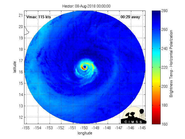
The CPHC is confusing me. In their discussion this morning I'm pretty sure they used a 126kt surface wind from a dropsonde to justify a 125kt intensity, when dropsonde winds are momentary gusts not sustained, but now they're iffy about a 119kt SFMR reading because it is near some suspect data. In my opinion, this storm is 120-125kts right now, not 115kts. Hector seems to be getting his act together again.
8 likes
Solar Aquarian
Lunar Cancerian
 Sagittarian
Lunar Cancerian
-
Eric Webb
Re: CPAC: HECTOR - Hurricane
0z BEST track keeps Hector at 115 KT.
EP, 10, 2018080800, , BEST, 0, 165N, 1500W, 115, 952,
EP, 10, 2018080800, , BEST, 0, 165N, 1500W, 115, 952,
0 likes

Re: CPAC: HECTOR - Hurricane
Hector is weakening some more during the past few hours, looks like some dry air is starting to do its magic just as forecasted by models.

0 likes
-
Eric Webb
Re: CPAC: HECTOR - Hurricane
I’m expecting recon to find a category 3 given degradation on satellite and how close it already was for the cat 3-4 border.
1 likes
-
Eric Webb
Re: CPAC: HECTOR - Hurricane
NDG wrote:Hector is weakening some more during the past few hours, looks like some dry air is starting to do its magic just as forecasted by models.
That doesn’t look like dry air to me if anything it’s another ERC there’s a huge spiral band around the old inner eyewall.
3 likes

Re: CPAC: HECTOR - Hurricane

0 likes
Kendall -> SLO -> PBC
Memorable Storms: Katrina (for its Florida landfall...) Wilma Matthew Irma
Memorable Storms: Katrina (for its Florida landfall...) Wilma Matthew Irma
Re: CPAC: HECTOR - Hurricane
Eric Webb wrote:NDG wrote:Hector is weakening some more during the past few hours, looks like some dry air is starting to do its magic just as forecasted by models.
https://i.imgur.com/blkvhwm.gif
That doesn’t look like dry air to me if anything it’s another ERC there’s a huge spiral band around the old inner eyewall.
This microwave is only a couple of hours old, right before its satellite presentation started deteriorating, it looks like a dry slot disrupted its eyewall. IMO.

3 likes
Re: CPAC: HECTOR - Hurricane
Looks like dry air intrusion to me
1 likes
Kendall -> SLO -> PBC
Memorable Storms: Katrina (for its Florida landfall...) Wilma Matthew Irma
Memorable Storms: Katrina (for its Florida landfall...) Wilma Matthew Irma
-
Kingarabian

- S2K Supporter

- Posts: 16353
- Joined: Sat Aug 08, 2009 3:06 am
- Location: Honolulu, Hawaii
Re: CPAC: HECTOR - Hurricane
Kingarabian wrote:Tropical storm warning for the big island.
TS winds are unlikely to get anywhere near the Big Island. Not understanding this warning at all
8 likes
-
Kingarabian
- S2K Supporter
- Posts: 16353
- Joined: Sat Aug 08, 2009 3:06 am
- Location: Honolulu, Hawaii
Re: CPAC: HECTOR - Hurricane
NDG wrote:Hector is weakening some more during the past few hours, looks like some dry air is starting to do its magic just as forecasted by models.
[img]https://i.imgur.com/blkvhwm.gif[/ig]
It's more that the SSTs are no longer able to support such a strong Hurricane. The models have been calling for weakening ever since it 1st became a major hurricane and have done a horrible job with Hectors intensity.
2 likes
RIP Kobe Bryant
-
CrazyC83
- Professional-Met

- Posts: 34315
- Joined: Tue Mar 07, 2006 11:57 pm
- Location: Deep South, for the first time!
Re: CPAC: HECTOR - Hurricane
Alyono wrote:Kingarabian wrote:Tropical storm warning for the big island.
TS winds are unlikely to get anywhere near the Big Island. Not understanding this warning at all
I'm wondering the same thing. I could see a watch being warranted for the southern tip of the island, but that is it. I'd say the chances of sustained TS winds on the island (not counting high elevation areas unrepresentative of the intensity) is under 20%.
0 likes
-
CrazyC83
- Professional-Met
- Posts: 34315
- Joined: Tue Mar 07, 2006 11:57 pm
- Location: Deep South, for the first time!
Re: CPAC: HECTOR - Hurricane
Ubuntwo wrote:Looks like dry air intrusion to me
The last few hours seems to show it closing back off though. Maybe it got into the eye and then mixed out.
1 likes
-
Eric Webb
Re: CPAC: HECTOR - Hurricane
NDG wrote:Eric Webb wrote:NDG wrote:Hector is weakening some more during the past few hours, looks like some dry air is starting to do its magic just as forecasted by models.
https://i.imgur.com/blkvhwm.gif
That doesn’t look like dry air to me if anything it’s another ERC there’s a huge spiral band around the old inner eyewall.
This microwave is only a couple of hours old, right before its satellite presentation started deteriorating, it looks like a dry slot disrupted its eyewall. IMO.
That much wasn’t dry air intrusion if in fact it actually was one. I don’t want to sound mean but you need to keep in mind for future reference that it’s really hard for dry air to work any “magic” on a small TC like Hector with a well established inner core esp when the shear is light. Either Hector needs to become larger, the shear needs to increase, or the SSTs need to cool even more from where they are now, neither of these will occur at least until Sunday and even then the moderate SWly shear on the GFS is questionable considering it can’t properly initialize the TC and its diabatic heating in the first place. It’s important to do this because heating of the mid-upper troposphere via deep convection is the only way to erode TUTTs and NWP often struggles with the former.
6 likes

Re: CPAC: HECTOR - Hurricane
The good news is it looks like Hector is moving wsw and even sw at times now. The bad news is the Euro and probably other models are still showing the terrible long range outcome for the hurricane that would be a waste of a beast. We really need one that is moving west at 8ºN and staying low. One that is just north of the ITCZ so it doesn't get caught up in that.
0 likes
-
xtyphooncyclonex

- Category 5

- Posts: 3891
- Age: 24
- Joined: Sat Dec 08, 2012 9:07 am
- Location: Cebu City
- Contact:
Re: CPAC: HECTOR - Hurricane
Hector is actually losing latitude more (and earlier) than what I expected
0 likes
REMINDER: My opinions that I, or any other NON Pro-Met in this forum, are unofficial. Please do not take my opinions as an official forecast and warning. I am NOT a meteorologist. Following my forecasts blindly may lead to false alarm, danger and risk if official forecasts from agencies are ignored.
-
Eric Webb
Re: CPAC: HECTOR - Hurricane
xtyphooncyclonex wrote:Hector is actually losing latitude more (and earlier) than what I expected
I discussed this briefly on my twitter account, but this is due to terrain blocking by the mountains of Hawaii, if you watched visible satellite yesterday very carefully you could see trade wind flow accelerating towards the Southwest wrk out ahead of Hector on the southeast side of the big island. This will deflect the track of Hector slightly to the south on approach then he may gain latitude again on the other side of the island when the flow decelerates again
6 likes
-
Eric Webb
Re: CPAC: HECTOR - Hurricane
Cyclenall wrote:The good news is it looks like Hector is moving wsw and even sw at times now. The bad news is the Euro and probably other models are still showing the terrible long range outcome for the hurricane that would be a waste of a beast. We really need one that is moving west at 8ºN and staying low. One that is just north of the ITCZ so it doesn't get caught up in that.
That’s extremely difficult to do for a number of reasons one of them due to beta advection out of the ITCZ and/or monsoon trough where Hector and many other storms originate. This process relies on differences in the coriolis parameter across the breadth of the developing TC and causes it to briefly move northwestward and gain significantly latitude right when they detach from the ITCZ. You see this all the time with TCs that form in the eastern Atlantic
1 likes


Re: CPAC: HECTOR - Hurricane
About 30 units of ACE now for Hector.
1 likes
The above post and any post by Ntxw is NOT an official forecast and should not be used as such. It is just the opinion of the poster and may or may not be backed by sound meteorological data. It is NOT endorsed by any professional institution including Storm2k. For official information, please refer to NWS products.
Help support Storm2K!

Re: CPAC: HECTOR - Hurricane
Eric Webb wrote:NDG wrote:Eric Webb wrote:That doesn’t look like dry air to me if anything it’s another ERC there’s a huge spiral band around the old inner eyewall.
This microwave is only a couple of hours old, right before its satellite presentation started deteriorating, it looks like a dry slot disrupted its eyewall. IMO.
https://i.imgur.com/i8xHs2q.jpg
That much wasn’t dry air intrusion if in fact it actually was one. I don’t want to sound mean but you need to keep in mind for future reference that it’s really hard for dry air to work any “magic” on a small TC like Hector with a well established inner core esp when the shear is light. Either Hector needs to become larger, the shear needs to increase, or the SSTs need to cool even more from where they are now, neither of these will occur at least until Sunday and even then the moderate SWly shear on the GFS is questionable considering it can’t properly initialize the TC and its diabatic heating in the first place. It’s important to do this because heating of the mid-upper troposphere via deep convection is the only way to erode TUTTs and NWP often struggles with the former.
I understand that shear needs to really increase for any significant dry air intrusion to occur, but whatever it is it disrupted for a brief moment its core and it sure lost some strength as indicated by the recon compared to 24-48 hrs ago. Perhaps it was the slightly cooler SSTs just SE of the big island of Hawaii near 26C instead of the near 27C waters that it was tracking over the past few days. Thanks for the explanation of how TUTTs get eroded.
3 likes
Who is online
Users browsing this forum: No registered users and 57 guests