CPAC: LANE - Post-Tropical

Moderator: S2k Moderators

Message
Author
User avatar
Ntxw
Storm2k Moderator
Storm2k Moderator
Posts: 22784
Joined: Wed Oct 21, 2009 6:34 pm
Location: DFW, Texas

Re: EPAC: LANE - Tropical Storm

#121 Postby Ntxw » Wed Aug 15, 2018 9:49 pm

TheStormExpert wrote:Slightly off topic but Hawaii would be prone to more hurricane hits had the island chain been oriented more north to south as opposed to east to west like it is. They’ve REALLY lucked out over the years.


With warming SSTs and expanding hadley cell, there will come a time Hawaii will be frequented by such systems. You won't need a big El Nino, nor strong +PDO for these systems to survive the track west.
1 likes   
The above post and any post by Ntxw is NOT an official forecast and should not be used as such. It is just the opinion of the poster and may or may not be backed by sound meteorological data. It is NOT endorsed by any professional institution including Storm2k. For official information, please refer to NWS products.

  Help support Storm2K!
Help Support Storm2K

User avatar
mrbagyo
Category 5
Category 5
Posts: 3715
Age: 33
Joined: Thu Apr 12, 2012 9:18 am
Location: 14.13N 120.98E
Contact:

Re: EPAC: LANE - Tropical Storm

#122 Postby mrbagyo » Wed Aug 15, 2018 10:23 pm

Image
0 likes   
The posts in this forum are NOT official forecast and should not be used as such. They are just the opinion of the poster and may or may not be backed by sound meteorological data. They are NOT endorsed by any professional institution or storm2k.org. For official information, please refer to RSMC, NHC and NWS products.

ncapps
Tropical Storm
Tropical Storm
Posts: 105
Joined: Wed Aug 15, 2018 7:53 am

Re: EPAC: LANE - Tropical Storm

#123 Postby ncapps » Wed Aug 15, 2018 11:46 pm

0Z GFS shifts closer to the Euro, not all the way their, but some. I still think the GFS is too slow with the storm, especially once it nears Hawaii. Not as fast as the CMC, but close.
0 likes   

User avatar
Kingarabian
S2K Supporter
S2K Supporter
Posts: 15980
Joined: Sat Aug 08, 2009 3:06 am
Location: Honolulu, Hawaii

Re: EPAC: LANE - Tropical Storm

#124 Postby Kingarabian » Thu Aug 16, 2018 12:23 am

ncapps wrote:0Z GFS shifts closer to the Euro, not all the way their, but some. I still think the GFS is too slow with the storm, especially once it nears Hawaii. Not as fast as the CMC, but close.


It's not as close to Hawaii as the 18z run, but the synoptic differences between it and the Euro are still there. Euro keeps a stronger ridge and weaker system moving west, GFS has a stronger systems that also attempts to recurve due to the ridge weakening.

And the GFSs solution is mirrored by the strongest members of the 12zEPS and 18zGEFS.

So with 200 hours out a lot can change.
0 likes   
RIP Kobe Bryant

User avatar
Kingarabian
S2K Supporter
S2K Supporter
Posts: 15980
Joined: Sat Aug 08, 2009 3:06 am
Location: Honolulu, Hawaii

Re: EPAC: LANE - Tropical Storm

#125 Postby Kingarabian » Thu Aug 16, 2018 1:50 am

TXPZ25 KNES 160627
TCSENP

A. 14E (LANE)

B. 16/0600Z

C. 10.2N

D. 125.8W

E. THREE/GOES-E

F. T3.5/3.5/D1.5/24HRS

G. IR/EIR/SWIR

H. REMARKS...DT OF 3.5 IS BASED ON 0.9 BANDING. MET IS 3.0 AND PT IS
3.5. FT IS BASED ON DT.

I. ADDL POSITIONS

NIL


...RAMIREZ
0 likes   
RIP Kobe Bryant

User avatar
Kingarabian
S2K Supporter
S2K Supporter
Posts: 15980
Joined: Sat Aug 08, 2009 3:06 am
Location: Honolulu, Hawaii

Re: EPAC: LANE - Tropical Storm

#126 Postby Kingarabian » Thu Aug 16, 2018 2:05 am

Difference between the Euro and the GFS begins around hour 120:

Image

Also the Euro continues to show Lane much weaker than the GFS, which would make sense for it to continue moving west since the trough likely wont catch it.

I'm not sure if I believe the GFS with Lane's track, but intensity wise, SAB is up to T3.5, which would put Lane's pressure near 996mb and winds close to 55kkts, inline with the GFS's forecast.
0 likes   
RIP Kobe Bryant

User avatar
xtyphooncyclonex
Category 5
Category 5
Posts: 3861
Age: 23
Joined: Sat Dec 08, 2012 9:07 am
Location: Cebu City
Contact:

Re: EPAC: LANE - Tropical Storm

#127 Postby xtyphooncyclonex » Thu Aug 16, 2018 4:59 am

WHAT IF this ends up crossing the West Pacific? Just... interesting. Two EPac-originating hurricanes in a year
0 likes   
REMINDER: My opinions that I, or any other NON Pro-Met in this forum, are unofficial. Please do not take my opinions as an official forecast and warning. I am NOT a meteorologist. Following my forecasts blindly may lead to false alarm, danger and risk if official forecasts from agencies are ignored.

User avatar
cycloneye
Admin
Admin
Posts: 145295
Age: 68
Joined: Thu Oct 10, 2002 10:54 am
Location: San Juan, Puerto Rico

Re: EPAC: LANE - Tropical Storm

#128 Postby cycloneye » Thu Aug 16, 2018 5:20 am

Tropical Storm Lane Discussion Number 6
NWS National Hurricane Center Miami FL EP142018
200 AM PDT Thu Aug 16 2018

The latest satellite images suggest that Lane is getting better
organized with its cloud pattern now consisting of a central dense
overcast feature and curved bands over the western semicircle.
There is a large spread in the intensity estimates tonight.
All of the Dvorak-based estimates have increased to 3.5/55 kt.
However, an ASCAT pass around 0600 UTC showed maximum winds of only
35 kt. Since Lane is a compact system, it is possible that the
resolution of ASCAT is not sufficient to capture its maximum winds,
therefore, the initial intensity is held at 45 kt as a compromise of
these data. It should be noted that this is a low confidence
initial intensity estimate.

Lane is now moving due westward at 10 kt steered by the flow on the
south side of a deep-layer ridge. The global models all show a
mid- to upper-level trough off the Baja California peninsula
cutting off and moving westward during the next few days. This
feature will weaken the ridge a little, and that should cause Lane
to make a slight turn to the west-northwest in a couple of days.
The models are tightly clustered, and the NHC track forecast
lies near the middle of the guidance envelope. Based on this
forecast, Lane is expected to cross into the Central Pacific basin
this weekend.

The environmental conditions appear quite favorable for Lane to
strengthen. During the next several days, the wind shear near Lane
is expected to be less than 10 kt, humidity values relatively high,
and SSTs sufficently warm. Therefore, steady or even rapid
strengthening appears likely. The NHC intensity forecast continues
to lean toward the higher end of the model guidance, and shows Lane
becoming a hurricane in 12 to 24 hours, and a major hurricane within
the next few days. This forecast is in best agreement with the
HCCA model.

FORECAST POSITIONS AND MAX WINDS

INIT 16/0900Z 10.4N 126.4W 45 KT 50 MPH
12H 16/1800Z 10.6N 128.3W 55 KT 65 MPH
24H 17/0600Z 10.9N 131.0W 70 KT 80 MPH
36H 17/1800Z 11.4N 133.7W 85 KT 100 MPH
48H 18/0600Z 11.8N 136.4W 95 KT 110 MPH
72H 19/0600Z 13.1N 141.6W 105 KT 120 MPH
96H 20/0600Z 14.4N 146.3W 110 KT 125 MPH
120H 21/0600Z 15.1N 150.3W 100 KT 115 MPH

$$
Forecaster Cangialosi
0 likes   
Visit the Caribbean-Central America Weather Thread where you can find at first post web cams,radars
and observations from Caribbean basin members Click Here

User avatar
DioBrando
Category 4
Category 4
Posts: 904
Age: 28
Joined: Sun Aug 12, 2018 12:45 pm

Re: EPAC: LANE - Tropical Storm

#129 Postby DioBrando » Thu Aug 16, 2018 6:18 am

xtyphooncyclonex wrote:WHAT IF this ends up crossing the West Pacific? Just... interesting. Two EPac-originating hurricanes in a year

hmmm good point
if she did cross the wpac, would she be stronger or weaker than hector?
0 likes   
blonde stacey (xe/xem/xir)

User avatar
Blown Away
S2K Supporter
S2K Supporter
Posts: 10145
Joined: Wed May 26, 2004 6:17 am

Re: EPAC: LANE - Tropical Storm

#130 Postby Blown Away » Thu Aug 16, 2018 9:43 am

GFS still has a strong Lane nibbling around the big island in @8 days. Amazing all the activity around the big island over the years and no hurricane hits.
0 likes   
Hurricane Eye Experience: David 79, Irene 99, Frances 04, Jeanne 04, Wilma 05... EYE COMING MY WAY IN 2024…
Hurricane Brush Experience: Andrew 92, Erin 95, Floyd 99, Matthew 16, Irma 17, Ian 22, Nicole 22…

User avatar
cycloneye
Admin
Admin
Posts: 145295
Age: 68
Joined: Thu Oct 10, 2002 10:54 am
Location: San Juan, Puerto Rico

Re: EPAC: LANE - Tropical Storm

#131 Postby cycloneye » Thu Aug 16, 2018 9:56 am

Tropical Storm Lane Discussion Number 7
NWS National Hurricane Center Miami FL EP142018
800 AM PDT Thu Aug 16 2018

Lane appears to be intensifying this morning, with a more symmetric
presentation on satellite imagery and pulsing deep convection near
the center. A recent SSMI/S microwave pass indicates that an inner
core is trying to form, although it isn't well defined yet. The
current intensity estimates continue to display a large spread,
ranging from the overnight scatterometer data at low-end tropical-
storm strength, from hurricane strength in the TAFB Dvorak estimate.
The initial wind speed is set to 50 kt with the increased
organization, and this remains a low confidence estimate.

While so far Lane has only been slowly intensifying, the large-scale
environment appears favorable for more significant intensification
to occur soon, especially with current signs of a primitive inner
core. Thus the wind speed forecast will maintain the quick
strengthening from the previous forecast, and there remains a
significant chance that rapid intensification will occur during the
next few days. The biggest change from yesterday is that more of
the global models are indicating that westerly shear could affect
Lane in the central Pacific, so more weakening is shown at day 5.
Otherwise, the new NHC intensity forecast is very close to the
previous one and is on the higher side of the guidance.

The initial motion estimate is 275/11. The subtropical ridge to
the north of Lane should continue to be the dominant steering
mechanism, forcing the tropical cyclone to move westward or
west-northwestward for the next several days. While the model
spread is low in the short range, it notably increases by days 4/5.
The GFS-based guidance is showing Lane move slower than the rest of
the guidance, which allows the eastern periphery of the ridge to
erode due to an inverted mid-level trough, and consequently a more
poleward motion of the cyclone. The ECMWF and UKMET show Lane
moving faster and basically missing any influence of that trough,
causing the storm to move faster to the west. There are no
strong signals pointing me to either solution, so the official
forecast follows the trend of the consensus, which ends up slightly
west of the previous forecast.


FORECAST POSITIONS AND MAX WINDS

INIT 16/1500Z 10.6N 127.6W 50 KT 60 MPH
12H 17/0000Z 10.8N 129.4W 60 KT 70 MPH
24H 17/1200Z 11.2N 132.1W 75 KT 85 MPH
36H 18/0000Z 11.7N 134.9W 85 KT 100 MPH
48H 18/1200Z 12.2N 137.6W 95 KT 110 MPH
72H 19/1200Z 13.5N 142.7W 105 KT 120 MPH
96H 20/1200Z 14.7N 147.3W 105 KT 120 MPH
120H 21/1200Z 15.3N 151.5W 95 KT 110 MPH

$$
Forecaster Blake
0 likes   
Visit the Caribbean-Central America Weather Thread where you can find at first post web cams,radars
and observations from Caribbean basin members Click Here

User avatar
Ntxw
Storm2k Moderator
Storm2k Moderator
Posts: 22784
Joined: Wed Oct 21, 2009 6:34 pm
Location: DFW, Texas

Re: EPAC: LANE - Tropical Storm

#132 Postby Ntxw » Thu Aug 16, 2018 9:56 am

Image
2 likes   
The above post and any post by Ntxw is NOT an official forecast and should not be used as such. It is just the opinion of the poster and may or may not be backed by sound meteorological data. It is NOT endorsed by any professional institution including Storm2k. For official information, please refer to NWS products.


  Help support Storm2K!

Help Support Storm2K


Alyono
Professional-Met
Professional-Met
Posts: 6961
Joined: Fri Apr 26, 2013 3:52 pm
Location: Texas Coast

Re: EPAC: LANE - Tropical Storm

#133 Postby Alyono » Thu Aug 16, 2018 11:16 am

looks like the entire recon fleet is going to Hawaii
2 likes   

ncapps
Tropical Storm
Tropical Storm
Posts: 105
Joined: Wed Aug 15, 2018 7:53 am

Re: EPAC: LANE - Tropical Storm

#134 Postby ncapps » Thu Aug 16, 2018 11:18 am

Seems like a trend towards a weaker storm is appearing in the GFS.


Image
Last edited by ncapps on Thu Aug 16, 2018 11:24 am, edited 1 time in total.
0 likes   

User avatar
gatorcane
S2K Supporter
S2K Supporter
Posts: 23691
Age: 47
Joined: Sun Mar 13, 2005 3:54 pm
Location: Boca Raton, FL

Re: EPAC: LANE - Tropical Storm

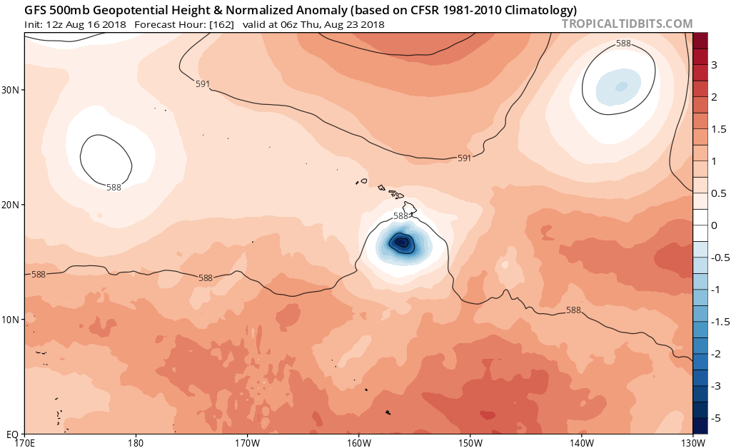
#135 Postby gatorcane » Thu Aug 16, 2018 11:22 am

Shift south on the 12Z GFS with a big ridge to the north of Hawaii:

Image
0 likes   

User avatar
Kingarabian
S2K Supporter
S2K Supporter
Posts: 15980
Joined: Sat Aug 08, 2009 3:06 am
Location: Honolulu, Hawaii

Re: EPAC: LANE - Tropical Storm

#136 Postby Kingarabian » Thu Aug 16, 2018 11:28 am

12z GFS is weaker now. Appears that intensity has track implications.
0 likes   
RIP Kobe Bryant

Alyono
Professional-Met
Professional-Met
Posts: 6961
Joined: Fri Apr 26, 2013 3:52 pm
Location: Texas Coast

Re: EPAC: LANE - Tropical Storm

#137 Postby Alyono » Thu Aug 16, 2018 11:35 am

UKMET and CMC shifted north
0 likes   

User avatar
Ntxw
Storm2k Moderator
Storm2k Moderator
Posts: 22784
Joined: Wed Oct 21, 2009 6:34 pm
Location: DFW, Texas

Re: EPAC: LANE - Tropical Storm

#138 Postby Ntxw » Thu Aug 16, 2018 11:39 am

Core is there and looks a lot better than past few days. Shouldn't be too long before being hurricane.

Image
3 likes   
The above post and any post by Ntxw is NOT an official forecast and should not be used as such. It is just the opinion of the poster and may or may not be backed by sound meteorological data. It is NOT endorsed by any professional institution including Storm2k. For official information, please refer to NWS products.


  Help support Storm2K!

Help Support Storm2K


ncapps
Tropical Storm
Tropical Storm
Posts: 105
Joined: Wed Aug 15, 2018 7:53 am

Re: EPAC: LANE - Tropical Storm

#139 Postby ncapps » Thu Aug 16, 2018 11:39 am

Alyono wrote:UKMET and CMC shifted north


Still weak, and quick though, at least for the CMC.
0 likes   

User avatar
Kingarabian
S2K Supporter
S2K Supporter
Posts: 15980
Joined: Sat Aug 08, 2009 3:06 am
Location: Honolulu, Hawaii

Re: EPAC: LANE - Tropical Storm

#140 Postby Kingarabian » Thu Aug 16, 2018 11:49 am

Ntxw wrote:Core is there and looks a lot better than past few days. Shouldn't be too long before being hurricane.

[img]http://i63.tinypic.com/2djqrr5.gif[/mg]


Core appeared to be developing on 5 hour old SSMIS pass. That cloud pattern looks really nice already and looks to me a strong TS becoming a hurricane very soon.
0 likes   
RIP Kobe Bryant


Return to “2018”

Who is online

Users browsing this forum: No registered users and 1 guest