CPAC: LANE - Post-Tropical
Moderator: S2k Moderators
-
BYG Jacob
Re: CPAC: LANE - Hurricane
That came out wrong
Last edited by BYG Jacob on Mon Aug 20, 2018 6:39 pm, edited 1 time in total.
0 likes
-
Kingarabian

- S2K Supporter

- Posts: 16366
- Joined: Sat Aug 08, 2009 3:06 am
- Location: Honolulu, Hawaii
Re: CPAC: LANE - Hurricane
18z HMON grazes the big island, but looks like Kailua-Kona may get Cat.1 conditions:

This also based on the notion that shear will actually be there to weaken Lane.
This also based on the notion that shear will actually be there to weaken Lane.
0 likes
RIP Kobe Bryant
-
johngaltfla

- Category 5

- Posts: 2073
- Joined: Sun Jul 10, 2005 9:17 pm
- Location: Sarasota County, FL
- Contact:
Re: CPAC: LANE - Hurricane
ncapps wrote:HMON is a hit for populated Kona area of BI. Maybe as Cat 2.
So much for my uncle's house on the water. This will not end well if this track holds.
0 likes
-
BYG Jacob
Re: CPAC: LANE - Hurricane
tolakram wrote:18Z GFS 0 - 114 hours.
[im g]https://i.imgur.com/E3tpaBq.gif[/img]
GFS hates Hawaii apparently
0 likes
-
Kingarabian
- S2K Supporter
- Posts: 16366
- Joined: Sat Aug 08, 2009 3:06 am
- Location: Honolulu, Hawaii
Re: CPAC: LANE - Hurricane
18z HWRF stronger and much closer to the big island too:

1 likes
RIP Kobe Bryant
-
Camerooski
- Tropical Low

- Posts: 47
- Joined: Wed Aug 08, 2018 5:40 pm
- Location: Lauderdale-By-the-Sea ---> Coral Gables
Re: CPAC: LANE - Hurricane
18z HWRF sure is scary to look at. BTW the models are actually hinting at a possible northern outflow boundary that will aid Lane as it makes the northerly turn, unreal.
0 likes
-
Kingarabian
- S2K Supporter
- Posts: 16366
- Joined: Sat Aug 08, 2009 3:06 am
- Location: Honolulu, Hawaii
Re: CPAC: LANE - Hurricane
Camerooski wrote:18z HWRF sure is scary to look at. BTW the models are actually hinting at a possible northern outflow boundary that will aid Lane as it makes the northerly turn, unreal.
Possibly keeping the strongest winds north, thus a better chance for those winds to reach the islands.
1 likes
RIP Kobe Bryant
-
Kingarabian
- S2K Supporter
- Posts: 16366
- Joined: Sat Aug 08, 2009 3:06 am
- Location: Honolulu, Hawaii


Re: CPAC: LANE - Hurricane
Not even sure Kauai and Ohau are affected in these scenarios besides passing showers and high surf...
0 likes
-
Kingarabian
- S2K Supporter
- Posts: 16366
- Joined: Sat Aug 08, 2009 3:06 am
- Location: Honolulu, Hawaii
Re: CPAC: LANE - Hurricane
18z FV3-GFS says that Lane will move north towards Oahu, stop, and get sheared to death:

0 likes
RIP Kobe Bryant
-
Kingarabian
- S2K Supporter
- Posts: 16366
- Joined: Sat Aug 08, 2009 3:06 am
- Location: Honolulu, Hawaii
Re: CPAC: LANE - Hurricane
18z GEFS mean, shifts more east, center closer to the islands:

1 likes
RIP Kobe Bryant
-
Kingarabian
- S2K Supporter
- Posts: 16366
- Joined: Sat Aug 08, 2009 3:06 am
- Location: Honolulu, Hawaii
Re: CPAC: LANE - Hurricane
Looks like a Cat.1 Maui landfall on the 18z HWRF. That's a big difference than its past 2 runs and showing much less shear over the system.
1 likes
RIP Kobe Bryant
-
Kingarabian
- S2K Supporter
- Posts: 16366
- Joined: Sat Aug 08, 2009 3:06 am
- Location: Honolulu, Hawaii
Re: CPAC: LANE - Hurricane
Mark Suddeth (Hurricanetrack) might be coming to Hawaii in the next couple of days
2 likes
RIP Kobe Bryant
-
Kingarabian
- S2K Supporter
- Posts: 16366
- Joined: Sat Aug 08, 2009 3:06 am
- Location: Honolulu, Hawaii
Re: CPAC: LANE - Hurricane
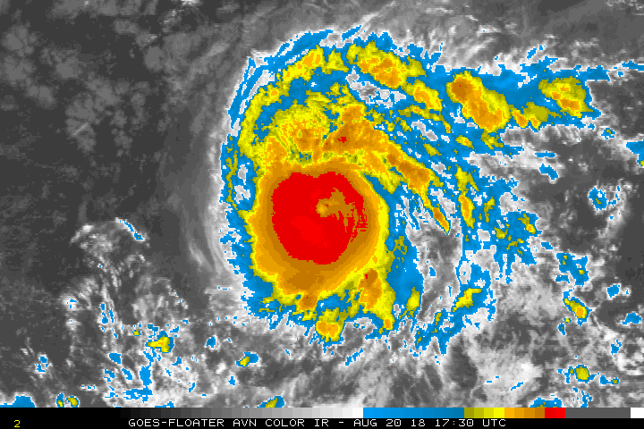
Healthy major hurricane. This AMSR2 pass shows that a possible ERC will possibly start soon:

1 likes
RIP Kobe Bryant
-
BYG Jacob
Re: CPAC: LANE - Hurricane
Getting real close to the panic buttonKingarabian wrote:Looks like a Cat.1 Maui landfall on the 18z HWRF. That's a big difference than its past 2 runs and showing much less shear over the system.
0 likes


Re: CPAC: LANE - Hurricane
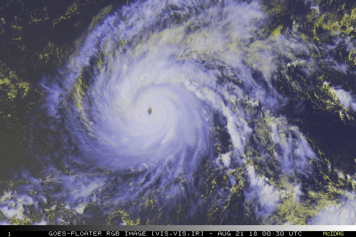
Lane's eye is warming. Wouldn't be too surprised if next plane finds a stronger storm
2 likes
The above post and any post by Ntxw is NOT an official forecast and should not be used as such. It is just the opinion of the poster and may or may not be backed by sound meteorological data. It is NOT endorsed by any professional institution including Storm2k. For official information, please refer to NWS products.
Help support Storm2K!

-
Yellow Evan

- Professional-Met

- Posts: 16240
- Age: 27
- Joined: Fri Jul 15, 2011 12:48 pm
- Location: Henderson, Nevada/Honolulu, HI
- Contact:
Re: CPAC: LANE - Hurricane
Not too sure about that.
TXPN41 PHFO 202356
TCSNP1
CENTRAL PACIFIC TROPICAL CYCLONE SUMMARY - FIXES
NWS CENTRAL PACIFIC HURRICANE CENTER HONOLULU HI
2355 UTC MON AUG 20 2018
A. HURRICANE LANE EP142018.
B. 20/2330Z.
C. 13.7N.
D. 149.6W.
E. GOES-W.
F. T6.0/6.0/D1.0/24HRS.
G. IR/EIR.
H. Remarks: EYE PATTERN WITH OW EYE AND B MEETING THE NARROWEST WIDTH REQUIREMENT YIELDING EYE NUMBER OF 6.0. A B RING ADDS 0.5 EYE ADJUSTMENT YIELDING A DT OF 6.0. PT AND MET AGREE. FT BASED ON DT.
I. ADDL POSITIONS NONE.
$$
TS.
0 likes
-
Yellow Evan
- Professional-Met
- Posts: 16240
- Age: 27
- Joined: Fri Jul 15, 2011 12:48 pm
- Location: Henderson, Nevada/Honolulu, HI
- Contact:
Re: CPAC: LANE - Hurricane
JTWC fix is spot on for a change.
TPPZ01 PGTW 210010 COR
A. HURRICANE 14E (LANE)
B. 20/2331Z
C. 13.80N
D. 149.66W
E. THREE/GOES15
F. T5.5/5.5/D1.0/24HRS STT: D0.5/03HRS
G. IR/EIR
H. REMARKS: 09A/PBO RAGGED EYE/ANMTN. OW EYE SURROUNDED BY LG
YIELDS AN E# OF 5.0. ADDED 0.5 FOR EYE ADJUSTMENT TO YIELD A DT
OF 5.5. MET AND PT AGREE. DBO DT. COR DUE TO INTENSITY
CORRECTION IN LINE F.
I. ADDITIONAL POSITIONS: NONE
LOWE
0 likes
-
Yellow Evan
- Professional-Met
- Posts: 16240
- Age: 27
- Joined: Fri Jul 15, 2011 12:48 pm
- Location: Henderson, Nevada/Honolulu, HI
- Contact:
Re: CPAC: LANE - Hurricane
TXPN24 KNES 202354
TCSCNP
A. 14E (LANE)
B. 20/2330Z
C. 13.8N
D. 149.7W
E. ONE/GOES-W
F. T5.5/5.5/D1.0/24HRS
G. IR/EIR/VIS
H. REMARKS...OW EYE IS EMBEDDED IN LG AND SURROUNDED BY B RESULTING IN
A DT OF 5.5 AFTER 0.5 IS ADDED AS AN EYE ADJUSTMENT. MET AND PT ARE ALSO
5.5. FT IS BASED ON DT.
I. ADDL POSITIONS
NIL
...TURK
0 likes
-
Blown Away

- S2K Supporter
- Posts: 10253
- Joined: Wed May 26, 2004 6:17 am
Re: CPAC: LANE - Hurricane
TVCN & EPS consistently remain a few hundred miles offshore... Seems like a close brush ATM...
0 likes
Hurricane Eye Experience: David 79, Irene 99, Frances 04, Jeanne 04, Wilma 05… Hurricane Brush Experience: Andrew 92, Erin 95, Floyd 99, Matthew 16, Irma 17, Ian 22, Nicole 22…
Who is online
Users browsing this forum: No registered users and 168 guests