CPAC: LANE - Post-Tropical
Moderator: S2k Moderators
-
gatorcane

- S2K Supporter

- Posts: 23708
- Age: 48
- Joined: Sun Mar 13, 2005 3:54 pm
- Location: Boca Raton, FL
Re: CPAC: LANE - Hurricane
The ECMWF and the ensemble mean though shifted east earlier are still west of the islands. That is about as close as it gets which is still quite a bit west and that is a day 4 forecast so not that far out:
Last edited by gatorcane on Mon Aug 20, 2018 8:24 pm, edited 2 times in total.
1 likes


Re: CPAC: LANE - Hurricane
Broad view of EPAC+CPAC

2 likes
The above post and any post by Ntxw is NOT an official forecast and should not be used as such. It is just the opinion of the poster and may or may not be backed by sound meteorological data. It is NOT endorsed by any professional institution including Storm2k. For official information, please refer to NWS products.
Help support Storm2K!

-
Kingarabian

- S2K Supporter
- Posts: 16366
- Joined: Sat Aug 08, 2009 3:06 am
- Location: Honolulu, Hawaii
Re: CPAC: LANE - Hurricane
Ntxw wrote:Lane's eye is warming. Wouldn't be too surprised if next plane finds a stronger storm
[img]https://images2.imgbox.com/d8/8c/m1KO1blC_o.gif[img]
[img]https://images2.imgbox.com/d1/a1/zVBeyXgc_o.jpg[img]
It's currently moving into an area of deeper warm waters, higher OHC, and a less stable environment. These three factors will help Lane to continue intensify. The only negating factor is shear. But with what appears to be an anti-cyclone following Lane, it'll take substantially more shear than currently analyzed to disrupt Lane's intensification process.

This gif shows how Lane has been able to continue to create a favorable upper level environment despite the models showing that it will weaken from un favorable shear.
Last edited by Kingarabian on Mon Aug 20, 2018 8:33 pm, edited 1 time in total.
1 likes
RIP Kobe Bryant
-
Kingarabian
- S2K Supporter
- Posts: 16366
- Joined: Sat Aug 08, 2009 3:06 am
- Location: Honolulu, Hawaii
Re: CPAC: LANE - Hurricane
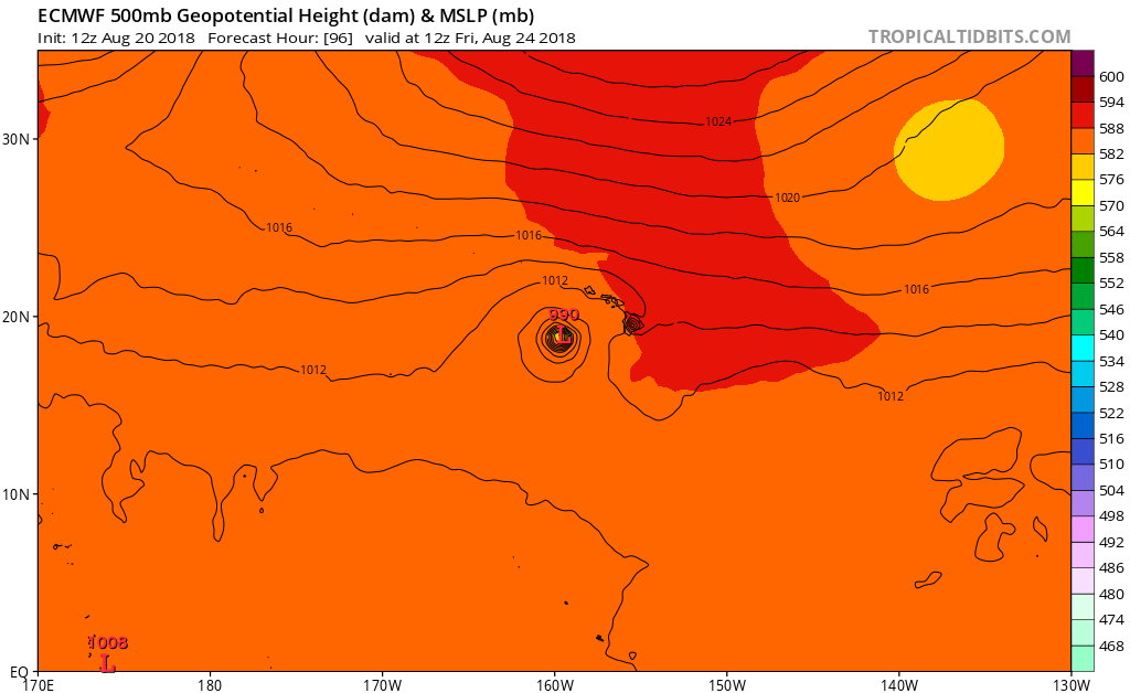
gatorcane wrote:The ECMWF and the ensemble mean though shifted east earlier are still west of the islands. That is about as close as it gets which is still quite a bit west and that is a day 4 forecast so not that far out:
[img]https://s8.postimg.cc/7gczyo151/ecmwf_z500_mslp_cpac_5.png[img]
Unless the upcoming 00z GFS run flips completely, and shows a track west of the islands, the current trend continues to favor the Euro shifting east.
The bend back to the west on your posted Euro and UK runs is due to shear breaking up the system and making it shallow thus caught up with the low level flow.
0 likes
RIP Kobe Bryant
-
gatorcane
- S2K Supporter
- Posts: 23708
- Age: 48
- Joined: Sun Mar 13, 2005 3:54 pm
- Location: Boca Raton, FL
Re: CPAC: LANE - Hurricane
The CMC is also similar to the ECMWF and west of the islands. Besides the GFS (and HWRF which is based on the GFS) what other model threatens Hawaii?
0 likes
-
Yellow Evan

- Professional-Met

- Posts: 16240
- Age: 27
- Joined: Fri Jul 15, 2011 12:48 pm
- Location: Henderson, Nevada/Honolulu, HI
- Contact:
Re: CPAC: LANE - Hurricane
gatorcane wrote:The CMC is also similar to the ECMWF and west of the islands. Besides the GFS (and HWRF which is based on the GFS) what other model threatens Hawaii?
The issue is that the ECMWF and UKMET have gradually been trended eastward and basically show what the GFS was showing 2-3 days ago. They've both been underestimating the intensity of this as well.
6 likes
-
Kingarabian
- S2K Supporter
- Posts: 16366
- Joined: Sat Aug 08, 2009 3:06 am
- Location: Honolulu, Hawaii
Re: CPAC: LANE - Hurricane
gatorcane wrote:The CMC is also similar to the ECMWF and west of the islands. Besides the GFS (and HWRF which is based on the GFS) what other model threatens Hawaii?
Well of course if someone decides to track Lane right now, the model solutions will not imply a threat to Hawaii. However if you take a look at the trend here, there's a great cause for concern:

4 likes
RIP Kobe Bryant
-
Kingarabian
- S2K Supporter
- Posts: 16366
- Joined: Sat Aug 08, 2009 3:06 am
- Location: Honolulu, Hawaii
Re: CPAC: LANE - Hurricane
Yellow Evan wrote:gatorcane wrote:The CMC is also similar to the ECMWF and west of the islands. Besides the GFS (and HWRF which is based on the GFS) what other model threatens Hawaii?
The issue is that the ECMWF and UKMET have gradually been trended eastward and basically show what the GFS was showing 2-3 days ago. They've both been underestimating the intensity of this as well.
This right here.
0 likes
RIP Kobe Bryant
Re: CPAC: LANE - Hurricane
gatorcane wrote:The CMC is also similar to the ECMWF and west of the islands. Besides the GFS (and HWRF which is based on the GFS) what other model threatens Hawaii?
the UKMET, JMA, and NAVGEM
0 likes
-
gatorcane
- S2K Supporter
- Posts: 23708
- Age: 48
- Joined: Sun Mar 13, 2005 3:54 pm
- Location: Boca Raton, FL
Re: CPAC: LANE - Hurricane
Kingarabian wrote:gatorcane wrote:The CMC is also similar to the ECMWF and west of the islands. Besides the GFS (and HWRF which is based on the GFS) what other model threatens Hawaii?
Well of course if someone decides to track Lane right now, the model solutions will not imply a threat to Hawaii. However if you take a look at the trend here, there's a great cause for concern:
https://i.imgur.com/Asj88nM.gif
Yes that does raise an eyebrow. But the east shifts may be done, we will see how the guidance does tonight. The other thing is the TUTT will be around should it go the way of the GFS. Questions remain on how far south or north that TUTT will be. Good test for the FV3 GFS. It thinks the TUTT will rip it apart. Tough to get a significant landfalling hurricane in Hawaii, takes a near perfect setup. Let’s see if this is that time or not.
Last edited by gatorcane on Mon Aug 20, 2018 8:42 pm, edited 3 times in total.
2 likes
-
cycloneye

- Admin

- Posts: 149511
- Age: 69
- Joined: Thu Oct 10, 2002 10:54 am
- Location: San Juan, Puerto Rico
Re: CPAC: LANE - Hurricane
Great video by Levi Cowan where he discusses all about Lane and the Hawaii impacts.
https://www.tropicaltidbits.com/blog/20 ... -possible/
https://www.tropicaltidbits.com/blog/20 ... -possible/
2 likes
Visit the Caribbean-Central America Weather Thread where you can find at first post web cams,radars
and observations from Caribbean basin members Click Here
and observations from Caribbean basin members Click Here
-
Twisted-core
Re: CPAC: LANE - Hurricane
Icon suggests with the lowering heights ridge retrogrades from the trough and almost u turns the cyclone before the ridge builds back in.

https://imgur.com/tKbRRdR

https://imgur.com/w8uAkMb
https://imgur.com/tKbRRdR
https://imgur.com/w8uAkMb
Last edited by Twisted-core on Mon Aug 20, 2018 8:47 pm, edited 1 time in total.
0 likes
-
Yellow Evan
- Professional-Met
- Posts: 16240
- Age: 27
- Joined: Fri Jul 15, 2011 12:48 pm
- Location: Henderson, Nevada/Honolulu, HI
- Contact:
Re: CPAC: LANE - Hurricane
gatorcane wrote:Kingarabian wrote:gatorcane wrote:The CMC is also similar to the ECMWF and west of the islands. Besides the GFS (and HWRF which is based on the GFS) what other model threatens Hawaii?
Well of course if someone decides to track Lane right now, the model solutions will not imply a threat to Hawaii. However if you take a look at the trend here, there's a great cause for concern:
https://i.imgur.com/Asj88nM.gif
Yes that does raise an eyebrow. But the east shifts may be done, we will see how the guidance does tonight. The other thing is the TUTT will be around should it go the way of the GFS. Questions remain on how far south or north that TUTT will be. Good test for the FV3 GFS. It thinks the TUTT will rip it apart. Thought to get a significant lamdfalling hurricane in Hawaii. Takes a near perfect setup. Let’s see if this is that time or not.
The models were previously showing this a while back falling apart due to the TUTT today, so the idea of increasing shear as a whole has kept getting pushed back. This isn't a done deal for a major hurricane landfall by any means thank goodness but at this point, I expect something somewhat similar to what the UKMET shows (a brush), which is further east than the ECMWF at best.
0 likes
-
1900hurricane

- Category 5

- Posts: 6063
- Age: 34
- Joined: Fri Feb 06, 2015 12:04 pm
- Location: Houston, TX
- Contact:
Re: CPAC: LANE - Hurricane
Based on the 18Z GFS, by 00Z Thursday, steering currents will become very weak in the vicinity of Lane. However, this is about when it switched to a primarily poleward component. This appears to be about the time Lane begins the turn.

1 likes
Contract Meteorologist. TAMU & MSST. Fiercely authentic, one of a kind. We are all given free will, so choose a life meant to be lived. We are the Masters of our own Stories.
Opinions expressed are mine alone.
Follow me on Twitter at @1900hurricane : Read blogs at https://1900hurricane.wordpress.com/
Opinions expressed are mine alone.
Follow me on Twitter at @1900hurricane : Read blogs at https://1900hurricane.wordpress.com/
-
SconnieCane
- Category 5
- Posts: 1013
- Joined: Thu Aug 02, 2018 5:29 pm
- Location: Madison, WI
Re: CPAC: LANE - Hurricane
Lane says "Shear? What shear?" Rolling across 150W just shy of 14N and beginning to assume the look of a high-end major.


4 likes
-
Hypercane_Kyle

- Category 5
- Posts: 3465
- Joined: Sat Mar 07, 2015 7:58 pm
- Location: Cape Canaveral, FL
Re: CPAC: LANE - Hurricane
Kingarabian wrote:gatorcane wrote:The CMC is also similar to the ECMWF and west of the islands. Besides the GFS (and HWRF which is based on the GFS) what other model threatens Hawaii?
Well of course if someone decides to track Lane right now, the model solutions will not imply a threat to Hawaii. However if you take a look at the trend here, there's a great cause for concern:
The ECMWF has done a poor job with Lane; was always too weak, too far south.
0 likes
My posts are my own personal opinion, defer to the National Hurricane Center (NHC) and other NOAA products for decision making during hurricane season.
-
1900hurricane
- Category 5
- Posts: 6063
- Age: 34
- Joined: Fri Feb 06, 2015 12:04 pm
- Location: Houston, TX
- Contact:
Re: CPAC: LANE - Hurricane
Here's some of the 500 mb features across the north Pacific by 12Z Thursday according to the 18Z GFS. The main players to me appear to be the subtle features closest to Lane at the time, but the amplifying mid-latitude pattern due to dual recurving typhoons is also playing a part. I also drew in a hypothetical steering flow region in the vicinity of Lane based on these features, just to try and visualize what all is going on.

4 likes
Contract Meteorologist. TAMU & MSST. Fiercely authentic, one of a kind. We are all given free will, so choose a life meant to be lived. We are the Masters of our own Stories.
Opinions expressed are mine alone.
Follow me on Twitter at @1900hurricane : Read blogs at https://1900hurricane.wordpress.com/
Opinions expressed are mine alone.
Follow me on Twitter at @1900hurricane : Read blogs at https://1900hurricane.wordpress.com/
Re: CPAC: LANE - Hurricane

7 likes
The above post and any post by Ntxw is NOT an official forecast and should not be used as such. It is just the opinion of the poster and may or may not be backed by sound meteorological data. It is NOT endorsed by any professional institution including Storm2k. For official information, please refer to NWS products.
Help support Storm2K!
Help support Storm2K!
-
Kingarabian
- S2K Supporter
- Posts: 16366
- Joined: Sat Aug 08, 2009 3:06 am
- Location: Honolulu, Hawaii
Who is online
Users browsing this forum: No registered users and 164 guests