
CPAC: LANE - Post-Tropical
Moderator: S2k Moderators
-
Kingarabian

- S2K Supporter

- Posts: 16367
- Joined: Sat Aug 08, 2009 3:06 am
- Location: Honolulu, Hawaii
Re: CPAC: LANE - Hurricane
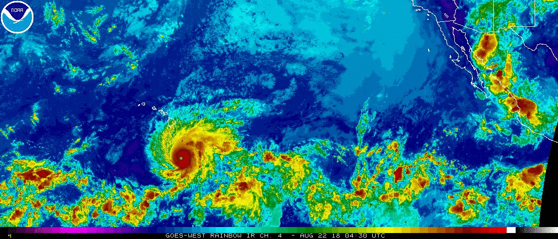
Could be temporarily fluctuations but it looks like Lane's CDO is expanding again on this frame with the red ring closed again:
0 likes
RIP Kobe Bryant
-
Twisted-core
Re: CPAC: LANE - Hurricane

https://imgur.com/jfVixjq

https://imgur.com/12hxn8S
some decent gusts from the south . Funneling may produce some stronger gusts locally if the model versifys..
@ the end of the run looks like it goes frontal.
0 likes

Re: CPAC: LANE - Hurricane
The good news this morning for Hawaii is that Lane has started feeling the shear thus weakening has begun as confirmed by the recon this morning.

0 likes
Re: CPAC: LANE - Hurricane
Pressure up to 938mb on the latest pass, peak flight level winds 130 knots.
Product: Air Force Vortex Message (URPN12 KNHC)
Transmitted: 22nd day of the month at 11:03Z
Agency: United States Air Force
Aircraft: Lockheed WC-130J Hercules with reg. number AF98-5307
Storm Number & Year: 14 in 2018
Storm Name: Lane (flight in the Northeast Pacific basin)
Mission Number: 12
Observation Number: 24
A. Time of Center Fix: 22nd day of the month at 10:35:40Z
B. Center Fix Coordinates: 14.74N 154.77W
B. Center Fix Location: 344 statute miles (554 km) to the S (177°) from Hilo, on the island of Hawaii, HI, USA.
C. Minimum Height at Standard Level: 2,558m (8,392ft) at 700mb
D. Minimum Sea Level Pressure: 938mb (27.70 inHg)
E. Dropsonde Surface Wind at Center: From 265° at 8kts (From the W at 9mph)
F. Eye Character: Closed
G. Eye Shape & Diameter: Circular with a diameter of 14 nautical miles (16 statute miles)
H. Estimated (by SFMR or visually) Maximum Surface Wind Inbound: 102kts (117.4mph)
I. Location & Time of the Estimated Maximum Surface Wind Inbound: 8 nautical miles to the SSW (204°) of center fix at 10:33:00Z
J. Maximum Flight Level Wind Inbound: From 293° at 120kts (From the WNW at 138.1mph)
K. Location & Time of the Maximum Flight Level Wind Inbound: 6 nautical miles to the SSW (200°) of center fix at 10:33:30Z
L. Estimated (by SFMR or visually) Maximum Surface Wind Outbound: 124kts (142.7mph)
M. Location & Time of the Estimated Maximum Surface Wind Outbound: 11 nautical miles (13 statute miles) to the NNE/NE (34°) of center fix at 10:39:30Z
N. Maximum Flight Level Wind Outbound: From 127° at 130kts (From the SE at 149.6mph)
O. Location & Time of the Maximum Flight Level Wind Outbound: 11 nautical miles (13 statute miles) to the NNE/NE (34°) of center fix at 10:39:30Z
P. Maximum Flight Level Temp & Pressure Altitude Outside Eye: 11°C (52°F) at a pressure alt. of 3,048m (10,000ft)
Q. Maximum Flight Level Temp & Pressure Altitude Inside Eye: 22°C (72°F) at a pressure alt. of 3,052m (10,013ft)
R. Dewpoint Temp (collected at same location as temp inside eye): 13°C (55°F)
R. Sea Surface Temp (collected at same location as temp inside eye): Not Available
S. Fix Determined By: Penetration, Radar, Wind, Pressure and Temperature
S. Fix Level: 700mb
T. Navigational Fix Accuracy: 0.02 nautical miles
T. Meteorological Accuracy: 1 nautical mile
Remarks Section:
Maximum Flight Level Wind: 134kts (~ 154.2mph) which was observed 32 nautical miles (37 statute miles) to the E (97°) from the flight level center at 7:02:30Z
0 likes

-
cycloneye

- Admin

- Posts: 149520
- Age: 69
- Joined: Thu Oct 10, 2002 10:54 am
- Location: San Juan, Puerto Rico
Re: CPAC: LANE - Hurricane
BULLETIN
Hurricane Lane Intermediate Advisory Number 31A
NWS Central Pacific Hurricane Center Honolulu HI EP142018
200 AM HST Wed Aug 22 2018
...POWERFUL HURRICANE LANE MOVING WEST NORTHWESTWARD TOWARD THE
MAIN HAWAIIAN ISLANDS...
SUMMARY OF 200 AM HST...1200 UTC...INFORMATION
----------------------------------------------
LOCATION...14.9N 155.0W
ABOUT 335 MI...540 KM S OF KAILUA-KONA HAWAII
ABOUT 480 MI...770 KM SSE OF HONOLULU HAWAII
MAXIMUM SUSTAINED WINDS...160 MPH...260 KM/H
PRESENT MOVEMENT...WNW OR 290 DEGREES AT 9 MPH...15 KM/H
MINIMUM CENTRAL PRESSURE...935 MB...27.61 INCHES
0 likes
Visit the Caribbean-Central America Weather Thread where you can find at first post web cams,radars
and observations from Caribbean basin members Click Here
and observations from Caribbean basin members Click Here


Re: CPAC: LANE - Hurricane
Lane peaked yesterday afternoon and evening and has weakened some since. However still remains a dangerous storm for the Hawaiian islands, hopefully everyone there has done their homework and done preparing. He is getting closer.
2 likes
The above post and any post by Ntxw is NOT an official forecast and should not be used as such. It is just the opinion of the poster and may or may not be backed by sound meteorological data. It is NOT endorsed by any professional institution including Storm2k. For official information, please refer to NWS products.
Help support Storm2K!


-
SconnieCane
- Category 5

- Posts: 1013
- Joined: Thu Aug 02, 2018 5:29 pm
- Location: Madison, WI
Re: CPAC: LANE - Hurricane
Well, we got our operationally recognized CPAC Cat 5. Now let the wobble watching and nail-biting begin in earnest. Much like the timing of Irma's right hook into FL last year, this is yet another case where subtle/margin-of-error differences between solutions and where the hurricane actually goes will mean massive differences in impacts.
0 likes
-
gatorcane

- S2K Supporter
- Posts: 23708
- Age: 48
- Joined: Sun Mar 13, 2005 3:54 pm
- Location: Boca Raton, FL
Re: CPAC: LANE - Hurricane
0 likes
-
hawaiigirl

- Tropical Depression

- Posts: 51
- Age: 41
- Joined: Thu Aug 06, 2009 6:38 pm
-
gatorcane
- S2K Supporter
- Posts: 23708
- Age: 48
- Joined: Sun Mar 13, 2005 3:54 pm
- Location: Boca Raton, FL
Re: CPAC: LANE - Hurricane
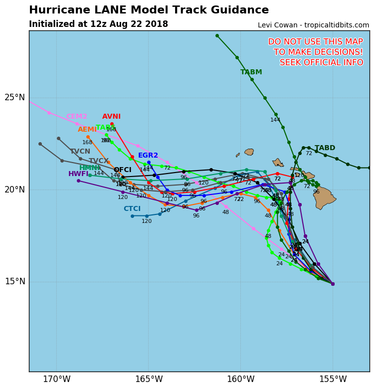
Seems the guidance has gradually shifted west if you look back at the 18Z yesterday evening. Latest 12Z plots below:
0 likes

Re: CPAC: LANE - Hurricane
gatorcane wrote:00Z UKMET:
Hard to tell with the islands so small but it appears it is buying the GFS, I tend to listen to the UKMET when it comes to slow turns to the north.
0 likes
Re: CPAC: LANE - Hurricane
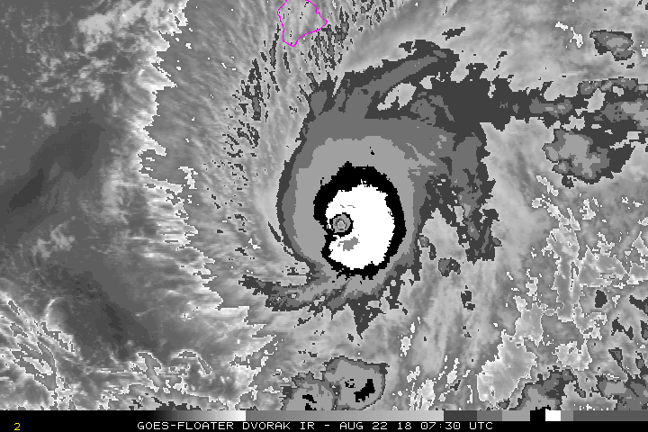
Some colder cloud tops, Hawaii needs this to weaken faster.
0 likes
The above post and any post by Ntxw is NOT an official forecast and should not be used as such. It is just the opinion of the poster and may or may not be backed by sound meteorological data. It is NOT endorsed by any professional institution including Storm2k. For official information, please refer to NWS products.
Help support Storm2K!
Help support Storm2K!
-
Yellow Evan

- Professional-Met

- Posts: 16241
- Age: 27
- Joined: Fri Jul 15, 2011 12:48 pm
- Location: Henderson, Nevada/Honolulu, HI
- Contact:
Re: CPAC: LANE - Hurricane
WTPA22 PHFO 221446
TCMCP2
HURRICANE LANE FORECAST/ADVISORY NUMBER 32
NWS CENTRAL PACIFIC HURRICANE CENTER HONOLULU HI EP142018
1500 UTC WED AUG 22 2018
CHANGES IN WATCHES AND WARNINGS WITH THIS ADVISORY...
A HURRICANE WARNING HAS BEEN ISSUED FOR...
* MAUI COUNTY...INCLUDING THE ISLANDS OF MAUI... LANAI... MOLOKAI
AND KAHOOLAWE
A HURRICANE WATCH HAS BEEN ISSUED FOR...
* KAUAI
SUMMARY OF WATCHES AND WARNINGS IN EFFECT...
A HURRICANE WARNING IS IN EFFECT FOR...
* HAWAII COUNTY
* MAUI COUNTY...INCLUDING THE ISLANDS OF MAUI... LANAI... MOLOKAI
AND KAHOOLAWE
A HURRICANE WATCH IS IN EFFECT FOR...
* OAHU
* KAUAI
A HURRICANE WARNING MEANS THAT HURRICANE CONDITIONS ARE EXPECTED
SOMEWHERE WITHIN THE WARNING AREA. A WARNING IS TYPICALLY ISSUED
36 HOURS BEFORE THE ANTICIPATED FIRST OCCURRENCE OF TROPICAL-STORM-
FORCE WINDS... CONDITIONS THAT MAKE OUTSIDE PREPARATIONS DIFFICULT
OR DANGEROUS. PREPARATIONS TO PROTECT LIFE AND PROPERTY SHOULD BE
RUSHED TO COMPLETION.
A HURRICANE WATCH MEANS THAT HURRICANE CONDITIONS ARE POSSIBLE
WITHIN THE WATCH AREA. A WATCH IS TYPICALLY ISSUED 48 HOURS BEFORE
THE ANTICIPATED FIRST OCCURRENCE OF TROPICAL-STORM-FORCE WINDS...
CONDITIONS THAT MAKE OUTSIDE PREPARATIONS DIFFICULT OR DANGEROUS.
INTERESTS ELSEWHERE IN THE MAIN HAWAIIAN ISLANDS... AND ACROSS THE
NORTHWESTERN HAWAIIAN ISLANDS... SHOULD CONTINUE TO CLOSELY MONITOR
THE PROGRESS OF HURRICANE LANE. ADDITIONAL TROPICAL STORM OR
HURRICANE WATCHES OR WARNINGS MAY BE ISSUED TONIGHT OR WEDNESDAY.
HURRICANE CENTER LOCATED NEAR 15.1N 155.3W AT 22/1500Z
POSITION ACCURATE WITHIN 20 NM
PRESENT MOVEMENT TOWARD THE WEST-NORTHWEST OR 290 DEGREES AT 8 KT
ESTIMATED MINIMUM CENTRAL PRESSURE 935 MB
EYE DIAMETER 15 NM
MAX SUSTAINED WINDS 135 KT WITH GUSTS TO 165 KT.
64 KT....... 35NE 25SE 15SW 30NW.
50 KT....... 65NE 40SE 30SW 60NW.
34 KT.......120NE 80SE 65SW 120NW.
12 FT SEAS..165NE 140SE 190SW 220NW.
WINDS AND SEAS VARY GREATLY IN EACH QUADRANT. RADII IN NAUTICAL
MILES ARE THE LARGEST RADII EXPECTED ANYWHERE IN THAT QUADRANT.
REPEAT...CENTER LOCATED NEAR 15.1N 155.3W AT 22/1500Z
AT 22/1200Z CENTER WAS LOCATED NEAR 14.9N 155.0W
FORECAST VALID 23/0000Z 15.8N 156.3W
MAX WIND 125 KT...GUSTS 150 KT.
64 KT... 35NE 20SE 20SW 30NW.
50 KT... 70NE 40SE 30SW 70NW.
34 KT...110NE 90SE 50SW 120NW.
FORECAST VALID 23/1200Z 17.1N 157.1W
MAX WIND 115 KT...GUSTS 140 KT.
64 KT... 30NE 20SE 20SW 30NW.
50 KT... 60NE 40SE 30SW 60NW.
34 KT...110NE 90SE 50SW 110NW.
FORECAST VALID 24/0000Z 18.4N 157.5W
MAX WIND 100 KT...GUSTS 120 KT.
64 KT... 30NE 20SE 20SW 30NW.
50 KT... 50NE 40SE 30SW 50NW.
34 KT...120NE 90SE 60SW 110NW.
FORECAST VALID 24/1200Z 19.7N 158.0W
MAX WIND 85 KT...GUSTS 105 KT.
64 KT... 30NE 20SE 20SW 30NW.
50 KT... 50NE 40SE 30SW 40NW.
34 KT...120NE 80SE 60SW 110NW.
FORECAST VALID 25/1200Z 21.0N 160.0W
MAX WIND 60 KT...GUSTS 75 KT.
50 KT... 40NE 30SE 20SW 30NW.
34 KT...110NE 70SE 40SW 80NW.
EXTENDED OUTLOOK. NOTE...ERRORS FOR TRACK HAVE AVERAGED NEAR 150 NM
ON DAY 4 AND 200 NM ON DAY 5...AND FOR INTENSITY NEAR 20 KT EACH DAY
OUTLOOK VALID 26/1200Z 20.8N 163.1W
MAX WIND 45 KT...GUSTS 55 KT.
OUTLOOK VALID 27/1200Z 20.6N 166.3W
MAX WIND 35 KT...GUSTS 45 KT.
REQUEST FOR 3 HOURLY SHIP REPORTS WITHIN 300 MILES OF 15.1N 155.3W
NEXT ADVISORY AT 22/2100Z
$$
FORECASTER POWELL
0 likes
-
xtyphooncyclonex

- Category 5
- Posts: 3892
- Age: 24
- Joined: Sat Dec 08, 2012 9:07 am
- Location: Cebu City
- Contact:
Re: CPAC: LANE - Hurricane
hawaiigirl wrote:Can’t sleep. Praying for any good news. Is there any yet?
It's moving more south and west than expected. It's possible that a direct landfall wouldn't take place. Some ensembles/models are gradually shifting west, but back and forth. Bad news: could be stronger than expected---to note, this was supposed to weaken into a cat 2 by now a few days ago.
Hoping for the best for all of you. You are all in my thoughts and prayers. Stay vigilant!
0 likes
REMINDER: My opinions that I, or any other NON Pro-Met in this forum, are unofficial. Please do not take my opinions as an official forecast and warning. I am NOT a meteorologist. Following my forecasts blindly may lead to false alarm, danger and risk if official forecasts from agencies are ignored.

Re: CPAC: LANE - Hurricane
WTPA42 PHFO 221513
TCDCP2
Hurricane Lane Discussion Number 32
NWS Central Pacific Hurricane Center Honolulu HI EP142018
500 AM HST Wed Aug 22 2018
A bit of asymmetry within the coldest cloud tops is now noticeable,
but Lane remains a well-organized hurricane this morning. Outflow
remains best to the north through east and is slightly restricted
elsewhere. Hurricane Hunter aircraft from the 53rd Weather
Reconnaissance Squadron flew through Lane once again overnight,
deriving 130 kt within the northeast eyewall (using a blend of
observations). Subjective Dvorak current intensity estimates were
6.5/127 kt from all three centers. ADT from UW-CIMSS was also
6.5/127 kt. Initial intensity is set at 135 kt for this advisory,
which is slightly lower than for the last advisory.
Initial motion for this advisory is 290/8 kt. Lane has likely
reached the western periphery of a mid-level ridge and has made its
anticipated turn toward the west northwest. Lane is forecast to
turn to the northwest later today, and to the north-northwest on
Thursday, as it moves between the mid-level ridge to the east and a
developing upper-level trough to the northwest of Hawaii. The track
and intensity forecasts become increasingly uncertain after this
point as most track guidance brings Lane very close to the islands,
with potential interaction between Lane and the mountainous terrain
of the islands. UW-CIMMS derives 15 kt of vertical shear now and
this is forecast to increase to 25 to 30 kt at 48 hours, according
to ECMWF SHIPS. The combination of land interaction and increasing
vertical shear leads to a weakened Lane being steered to the west by
the low-level trade wind flow during the later forecast periods. The
new track forecast closely resembles the previous one and follows
HCCA and TVCE between GFS and ECMWF. A slight bump to the left was
made through 36 hours to account for initial motion, while a slight
bump to the right was made to keep the track within the guidance
envelop at 48 and 72 hours.
Water temperatures along the forecast track will be 27 to 28
degrees C, warm enough to support a major hurricane. Therefore, any
significant weakening as Lane draws closer to the Hawaiian Islands
will likely be due to increasing wind shear. Through the next 36
hours, shear is expected to remain in the 10 to 20 kt range, and we
expect only slow weakening initially. At 48 hours and beyond, the
forecast incorporates an expected sharp increase in shear as Lane
moves closer to the large upper trough to the northwest of the main
Hawaiian Islands. The new intensity forecast is very similar to the
previous forecast and lies near the top of the guidance envelope
but not too far from HMNI and IVCN.
KEY MESSAGES:
1. Lane is forecast to move dangerously close to the main Hawaiian
Islands as a hurricane tomorrow through Saturday, potentially
bringing damaging winds and life-threatening flash flooding from
heavy rainfall. As Lane will be slow-moving as it nears the
islands, large and damaging surf can be expected along exposed
shorelines, along with localized storm surge.
2. As Lane approaches the islands from the southeast, initial
impacts will be felt on the Big Island and Maui County, where a
Hurricane Warning is in effect. Impacts on Kauai County and Oahu
are also possible, and a Hurricane Watch is in effect there.
3. Do not focus on the exact forecast track for Lane, as life-
threatening weather conditions extend well away from the center of
the hurricane, and significant impacts could be felt on any of the
islands.
FORECAST POSITIONS AND MAX WINDS
INIT 22/1500Z 15.1N 155.3W 135 KT 155 MPH
12H 23/0000Z 15.8N 156.3W 125 KT 145 MPH
24H 23/1200Z 17.1N 157.1W 115 KT 130 MPH
36H 24/0000Z 18.4N 157.5W 100 KT 115 MPH
48H 24/1200Z 19.7N 158.0W 85 KT 100 MPH
72H 25/1200Z 21.0N 160.0W 60 KT 70 MPH
96H 26/1200Z 20.8N 163.1W 45 KT 50 MPH
120H 27/1200Z 20.6N 166.3W 35 KT 40 MPH
$$
Forecaster Powell
0 likes
Who is online
Users browsing this forum: No registered users and 42 guests