CPAC: LANE - Post-Tropical

Moderator: S2k Moderators

Message
Author
User avatar
Kingarabian
S2K Supporter
S2K Supporter
Posts: 15980
Joined: Sat Aug 08, 2009 3:06 am
Location: Honolulu, Hawaii

Re: CPAC: LANE - Hurricane

#1701 Postby Kingarabian » Thu Aug 23, 2018 4:21 pm

Alyono wrote:I'm seeing some 35 kt upper winds over Lane now
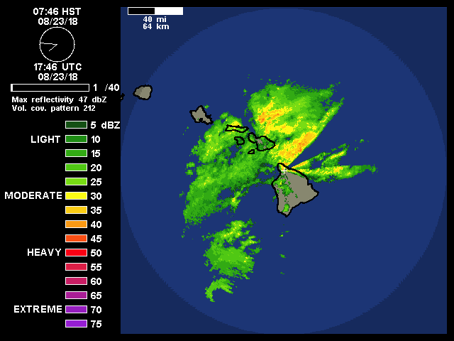
I hope they get the job done. Not that it was entirely possible, but I and many others who took the time prepped for a Cat.1 at most... Not an Iniki.
0 likes   
RIP Kobe Bryant

User avatar
Kingarabian
S2K Supporter
S2K Supporter
Posts: 15980
Joined: Sat Aug 08, 2009 3:06 am
Location: Honolulu, Hawaii

Re: CPAC: LANE - Hurricane

#1702 Postby Kingarabian » Thu Aug 23, 2018 4:23 pm

 https://twitter.com/RyanMaue/status/1032738216636571650


Ryan Maue | weathermodels.com
‏Verified account @RyanMaue
8m8 minutes ago

#HurricaneLane has made it to 157.5 west ... the satellite fixes showing a bit of a stepping sequence (black line) within the EPS ensemble members. The official forecast maintains an almost due North course for next 36-hours.
0 likes   
RIP Kobe Bryant

Aric Dunn
Category 5
Category 5
Posts: 21238
Age: 42
Joined: Sun Sep 19, 2004 9:58 pm
Location: Ready for the Chase.
Contact:

Re: CPAC: LANE - Hurricane

#1703 Postby Aric Dunn » Thu Aug 23, 2018 4:23 pm

Radar looks like it is moving Due north the last hour or so..
1 likes   
Note: If I make a post that is brief. Please refer back to previous posts for the analysis or reasoning. I do not re-write/qoute what my initial post said each time.
If there is nothing before... then just ask :)

Space & Atmospheric Physicist, Embry-Riddle Aeronautical University,
I believe the sky is falling...

User avatar
NDG
S2K Supporter
S2K Supporter
Posts: 15446
Joined: Sun Jul 09, 2006 10:14 pm
Location: Orlando, FL

Re: CPAC: LANE - Hurricane

#1704 Postby NDG » Thu Aug 23, 2018 4:29 pm

StormSkeptic wrote:
NDG wrote:I don't think this buoy will get over the SE eyewall of Lane, the pressure has not been falling much during the past few minutes, near 960mb, and the wind is shifting from the NNW.

Conditions at 51002 as of
(9:10 am HAST)
1910 GMT on 08/23/2018:
Unit of Measure: Time Zone:


Wind Direction Wind Direction (WDIR): NNW ( 340 deg true )
Wind Speed Wind Speed (WSPD): 25.3 kts
Wind Gust Wind Gust (GST): 44.7 kts
Atmospheric Pressure Atmospheric Pressure (PRES): 28.34 in
Wind Speed at 10 Meters Wind Speed at 10 meters (WSPD10M): 27.2 kts
Wind Speed at 10 Meters Wind Speed at 20 meters (WSPD20M): 29.1 kts


Pressure has bottomed out at the buoy at 28.24 in (956mb) with 2kts of wind, so we have our central pressure.


I see that, basically the eye went over the buoy, there's no way its pressure is as low as the latest advisory has it. I would say that its pressure is now up to 955mb.

Code: Select all

08   23   10:10 am   W   1.9   5.8   -   -   -   -   28.27   -   -   -   -   -   -   -
08   23   10:00 am   WNW   3.9   5.8   -   -   -   -   28.26   -0.87   -   -   -   -   -   -
08   23   9:50 am   WNW   1.9   5.8   25.6   10   8.2   NNE   28.25   -   -
0 likes   

Alyono
Professional-Met
Professional-Met
Posts: 6961
Joined: Fri Apr 26, 2013 3:52 pm
Location: Texas Coast

Re: CPAC: LANE - Hurricane

#1705 Postby Alyono » Thu Aug 23, 2018 4:32 pm

this has turned more to the left during the past few hours
0 likes   

User avatar
Kingarabian
S2K Supporter
S2K Supporter
Posts: 15980
Joined: Sat Aug 08, 2009 3:06 am
Location: Honolulu, Hawaii

Re: CPAC: LANE - Hurricane

#1706 Postby Kingarabian » Thu Aug 23, 2018 4:36 pm

Image

I see increased cirrus in the southern quads from the past few horus, but the CDO structure continues to stay put.
0 likes   
RIP Kobe Bryant

User avatar
Yellow Evan
Professional-Met
Professional-Met
Posts: 16143
Age: 27
Joined: Fri Jul 15, 2011 12:48 pm
Location: Henderson, Nevada/Honolulu, HI
Contact:

Re: CPAC: LANE - Hurricane

#1707 Postby Yellow Evan » Thu Aug 23, 2018 4:38 pm

Image

Okay this is back to weakening for sure at least for now.
0 likes   

Aric Dunn
Category 5
Category 5
Posts: 21238
Age: 42
Joined: Sun Sep 19, 2004 9:58 pm
Location: Ready for the Chase.
Contact:

Re: CPAC: LANE - Hurricane

#1708 Postby Aric Dunn » Thu Aug 23, 2018 4:39 pm

So looking at the models and the 850mb vorticity. I may have found the culprit and a reason to pay more attention to the models with this feature ( actually many others). especially the models that have this feature being stronger.

circled is a fairly large vortex that the models have shown developing. the models show many of these small to moderate sized vorts/circ that develop and rotate around to the north of Lane. This effectively lowers the pressure to the NE of Lane along with the lee side troughing should pull Lane NNE to NE. The Euro finally this run shows this feature being stronger than the 00z run and thus the track shift quite a good bit east.

loop http://www.ssd.noaa.gov/PS/TROP/floater ... -long.html
Image

Here is the HWRF showing a string of these vorts developing over time. this same thing happens with the GFS and other models.

Image

the 00z Euro does not have these features being well pronounced which allows Lane to move more NW.

12Z Euro today. notice how much larger ( which is what we are currently seeing with that vort feature) compared to the 00z. and the Euro in the 00z does not develop that string of vorts like the other models.

12z
Image
00z
Image

So the fact that this Feature is currently there and it is not a phantom of the models make the Dynamical models and the GFS and the 12z Euro more believable.
only time will tell if the lower pressure to the NE of Lane will be enough to bring the core onshore somewhere or not but it is a good possibility.


Also appears on radar to still be heading about due north.
Last edited by Aric Dunn on Thu Aug 23, 2018 4:40 pm, edited 1 time in total.
4 likes   
Note: If I make a post that is brief. Please refer back to previous posts for the analysis or reasoning. I do not re-write/qoute what my initial post said each time.
If there is nothing before... then just ask :)

Space & Atmospheric Physicist, Embry-Riddle Aeronautical University,
I believe the sky is falling...

User avatar
Kingarabian
S2K Supporter
S2K Supporter
Posts: 15980
Joined: Sat Aug 08, 2009 3:06 am
Location: Honolulu, Hawaii

Re: CPAC: LANE - Hurricane

#1709 Postby Kingarabian » Thu Aug 23, 2018 4:40 pm

06z GFS looks completely due north through 18 hours:

Image
0 likes   
RIP Kobe Bryant

Alyono
Professional-Met
Professional-Met
Posts: 6961
Joined: Fri Apr 26, 2013 3:52 pm
Location: Texas Coast

Re: CPAC: LANE - Hurricane

#1710 Postby Alyono » Thu Aug 23, 2018 4:40 pm

GFS back to Big Island?
0 likes   

User avatar
Kingarabian
S2K Supporter
S2K Supporter
Posts: 15980
Joined: Sat Aug 08, 2009 3:06 am
Location: Honolulu, Hawaii

Re: CPAC: LANE - Hurricane

#1711 Postby Kingarabian » Thu Aug 23, 2018 4:48 pm

06z GFS looks like a Maui landfall.

Image
0 likes   
RIP Kobe Bryant

tolakram
Admin
Admin
Posts: 20009
Age: 62
Joined: Sun Aug 27, 2006 8:23 pm
Location: Florence, KY (name is Mark)

Re: CPAC: LANE - Hurricane

#1712 Postby tolakram » Thu Aug 23, 2018 4:53 pm

supercane4867 wrote:That discussion makes me think CPHC just gave up on figuring out exact track and decides to blindly follow EPS mean


Please be careful with these kinds of statements. The CPHC has help from the NHC to make these forecasts, they are not in this alone and they are certainly not giving up.
5 likes   
M a r k
- - - - -
Join us in chat: Storm2K Chatroom Invite. Android and IOS apps also available.

The posts in this forum are NOT official forecasts and should not be used as such. Posts are NOT endorsed by any professional institution or STORM2K.org. For official information and forecasts, please refer to NHC and NWS products.

User avatar
Kingarabian
S2K Supporter
S2K Supporter
Posts: 15980
Joined: Sat Aug 08, 2009 3:06 am
Location: Honolulu, Hawaii

Re: CPAC: LANE - Hurricane

#1713 Postby Kingarabian » Thu Aug 23, 2018 4:59 pm

Alyono wrote:GFS back to Big Island?


HWRF and HMON will be interesting. Wonder if HMON will show a stronger vort.
0 likes   
RIP Kobe Bryant

tolakram
Admin
Admin
Posts: 20009
Age: 62
Joined: Sun Aug 27, 2006 8:23 pm
Location: Florence, KY (name is Mark)

Re: CPAC: LANE - Hurricane

#1714 Postby tolakram » Thu Aug 23, 2018 5:00 pm

1 likes   
M a r k
- - - - -
Join us in chat: Storm2K Chatroom Invite. Android and IOS apps also available.

The posts in this forum are NOT official forecasts and should not be used as such. Posts are NOT endorsed by any professional institution or STORM2K.org. For official information and forecasts, please refer to NHC and NWS products.

hurricaneCW
Category 5
Category 5
Posts: 1794
Joined: Wed Mar 03, 2010 6:20 am
Location: Toms River, NJ

Re: CPAC: LANE - Hurricane

#1715 Postby hurricaneCW » Thu Aug 23, 2018 5:03 pm

I'm not sure why everyones so adamant about whether this makes landfall or not, that really doesn't matter.

The real damage is and will always be the extreme rainfall totals. Even if it were to make LF the storm would be a low end Cat 1 at best as it's already starting to weaken.
3 likes   

User avatar
1900hurricane
Category 5
Category 5
Posts: 6059
Age: 34
Joined: Fri Feb 06, 2015 12:04 pm
Location: Houston, TX
Contact:

Re: CPAC: LANE - Hurricane

#1716 Postby 1900hurricane » Thu Aug 23, 2018 5:06 pm

TheAustinMan wrote:UW-CIMSS ADT is actually yielding raw values of T6.7/132kt. Assuming, of course, that the cloud system center is colocated with the observed warm spot.

14 kB. Source: CIMSS ADT
Image

I have to ask, how did you end up with that awesome graphic? Is that something you plotted yourself?
3 likes   
Contract Meteorologist. TAMU & MSST. Fiercely authentic, one of a kind. We are all given free will, so choose a life meant to be lived. We are the Masters of our own Stories.
Opinions expressed are mine alone.

Follow me on Twitter at @1900hurricane : Read blogs at https://1900hurricane.wordpress.com/

supercane4867
Category 5
Category 5
Posts: 4966
Joined: Wed Nov 14, 2012 10:43 am

Re: CPAC: LANE - Hurricane

#1717 Postby supercane4867 » Thu Aug 23, 2018 5:09 pm

Image
1 likes   

User avatar
Kingarabian
S2K Supporter
S2K Supporter
Posts: 15980
Joined: Sat Aug 08, 2009 3:06 am
Location: Honolulu, Hawaii

Re: CPAC: LANE - Hurricane

#1718 Postby Kingarabian » Thu Aug 23, 2018 5:12 pm

hurricaneCW wrote:I'm not sure why everyones so adamant about whether this makes landfall or not, that really doesn't matter.

The real damage is and will always be the extreme rainfall totals. Even if it were to make LF the storm would be a low end Cat 1 at best as it's already starting to weaken.


Cat.1 winds is bad for a state that historically does NOT get hurricanes.
3 likes   
RIP Kobe Bryant

aperson
S2K Supporter
S2K Supporter
Posts: 336
Age: 37
Joined: Thu Sep 22, 2005 10:56 pm

Re: CPAC: LANE - Hurricane

#1719 Postby aperson » Thu Aug 23, 2018 5:19 pm

From what I could gather, building code in Hawaii prior to special wind zone reclassification in the early 2000s was for 80mph sustained winds. A cat 1 vs cat 2 wind field would have significant impacts for older construction in this case. (see: http://martinchock.com/_library/documen ... isions.pdf)
2 likes   

User avatar
Kingarabian
S2K Supporter
S2K Supporter
Posts: 15980
Joined: Sat Aug 08, 2009 3:06 am
Location: Honolulu, Hawaii

Re: CPAC: LANE - Hurricane

#1720 Postby Kingarabian » Thu Aug 23, 2018 5:24 pm

aperson wrote:From what I could gather, building code in Hawaii prior to special wind zone reclassification in the early 2000s was for 80mph sustained winds. A cat 1 vs cat 2 wind field would have significant impacts for older construction in this case. (see: http://martinchock.com/_library/documen ... isions.pdf)


I agree with that completely.
0 likes   
RIP Kobe Bryant


Return to “2018”

Who is online

Users browsing this forum: No registered users and 4 guests