CPAC: LANE - Post-Tropical

Moderator: S2k Moderators

Message
Author
OahuWahine
Tropical Depression
Tropical Depression
Posts: 60
Age: 47
Joined: Tue Aug 21, 2018 4:03 am
Location: Mililani, HI

Re: CPAC: LANE - Hurricane

#1761 Postby OahuWahine » Thu Aug 23, 2018 8:14 pm

FLpanhandle91 wrote:
OahuWahine wrote:I have what might be a stupid question but keep in mind I've never had to board up for a hurricane before. We don't have enough plywood to board up all the windows and the stores are all out. We have large picture windows in our living room, but they are in the front of the house which faces to the north. Two of the bedrooms have large windows that face to the south toward Pearl Harbor. I'm thinking I need to use the wood on the bedroom windows.


So in Oahu, given the GFS and Euro solutions, most of your winds will have a northerly and westerly component to them. Southerly winds, as it stands, will not be a factor for the island of Oahu until Lane passes two your south in about 48 hours. I would make sure any West and North facing windows are boarded up.


Thank you!
0 likes   

boulderrr
Tropical Depression
Tropical Depression
Posts: 55
Joined: Mon Aug 22, 2016 11:30 am
Location: Nederland, Colorado - 8,500'

Re: CPAC: LANE - Hurricane

#1762 Postby boulderrr » Thu Aug 23, 2018 8:16 pm

OahuWahine wrote:I have what might be a stupid question but keep in mind I've never had to board up for a hurricane before. We don't have enough plywood to board up all the windows and the stores are all out. We have large picture windows in our living room, but they are in the front of the house which faces to the north. Two of the bedrooms have large windows that face to the south toward Pearl Harbor. I'm thinking I need to use the wood on the bedroom windows.


A big thing to consider is the windows' exposure to projectiles that can break them. Based on the current forecast track (and depending on the integrity of your windows), it is unlikely the winds alone will break your windows. Is one set of windows more exposed to tree limbs that could blow down and break those windows?

While the storm is to your southeast (earlier), you will be experiencing winds out of the east and north (TOWARD the west and south). As the storm turns west and passes to your south, you will experience winds first out of the east and then out of the south (TOWARD the west and north).

Your windows are most prone to tree limbs or other projectiles blowing into them as opposed to the severe winds compromising their integrity.

If one set of windows has a massive tree that sways like crazy hanging over it and the other has nothing nearby, I would board up the windows near the tree.

I traveled to the Big Island after Iselle to assess damages. There was very little apparent damage due to wind alone. All the damage we saw was due to trees and limbs falling on buildings.
Last edited by boulderrr on Thu Aug 23, 2018 8:22 pm, edited 1 time in total.
1 likes   

txwatcher91
Category 5
Category 5
Posts: 1498
Joined: Tue Aug 02, 2005 2:29 pm

Re: CPAC: LANE - Hurricane

#1763 Postby txwatcher91 » Thu Aug 23, 2018 8:22 pm

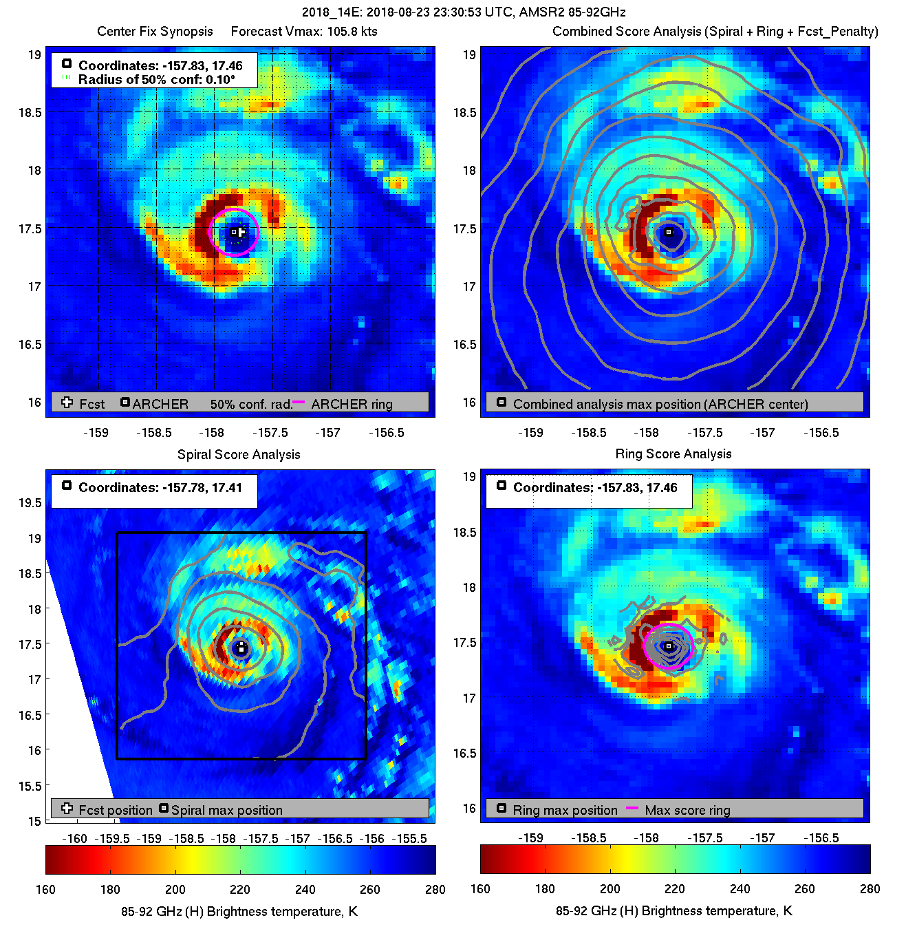
Latest microwave pass indicates increasing organization again.
Image
2 likes   

User avatar
Kingarabian
S2K Supporter
S2K Supporter
Posts: 15980
Joined: Sat Aug 08, 2009 3:06 am
Location: Honolulu, Hawaii

Re: CPAC: LANE - Hurricane

#1764 Postby Kingarabian » Thu Aug 23, 2018 8:29 pm

:uarrow: no.. please
3 likes   
RIP Kobe Bryant

User avatar
1900hurricane
Category 5
Category 5
Posts: 6059
Age: 34
Joined: Fri Feb 06, 2015 12:04 pm
Location: Houston, TX
Contact:

Re: CPAC: LANE - Hurricane

#1765 Postby 1900hurricane » Thu Aug 23, 2018 8:30 pm

Looks like it correlates pretty well with radar imagery.

 https://twitter.com/1900hurricane/status/1032802011178311681


0 likes   
Contract Meteorologist. TAMU & MSST. Fiercely authentic, one of a kind. We are all given free will, so choose a life meant to be lived. We are the Masters of our own Stories.
Opinions expressed are mine alone.

Follow me on Twitter at @1900hurricane : Read blogs at https://1900hurricane.wordpress.com/

User avatar
Kingarabian
S2K Supporter
S2K Supporter
Posts: 15980
Joined: Sat Aug 08, 2009 3:06 am
Location: Honolulu, Hawaii

Re: CPAC: LANE - Hurricane

#1766 Postby Kingarabian » Thu Aug 23, 2018 8:31 pm

Image

No doubt it remains a potent major hurricane.
4 likes   
RIP Kobe Bryant

SunnyThoughts
Category 5
Category 5
Posts: 2263
Joined: Wed Jul 09, 2003 12:42 pm
Location: Pensacola, Florida

Re: CPAC: LANE - Hurricane

#1767 Postby SunnyThoughts » Thu Aug 23, 2018 8:39 pm

Just caught the tail end of TWC discussion and apparently there is already water rescues going on with houses flooded on one of the Islands. Didn't catch which island...but the water is going to be the biggest story when all is said and done I believe. Of course with all the water ahead of the storm, if any significant winds at all hit those areas, any trees are going to be easily uprooted.
0 likes   

OahuWahine
Tropical Depression
Tropical Depression
Posts: 60
Age: 47
Joined: Tue Aug 21, 2018 4:03 am
Location: Mililani, HI

Re: CPAC: LANE - Hurricane

#1768 Postby OahuWahine » Thu Aug 23, 2018 8:42 pm

boulderrr wrote:
OahuWahine wrote:I have what might be a stupid question but keep in mind I've never had to board up for a hurricane before. We don't have enough plywood to board up all the windows and the stores are all out. We have large picture windows in our living room, but they are in the front of the house which faces to the north. Two of the bedrooms have large windows that face to the south toward Pearl Harbor. I'm thinking I need to use the wood on the bedroom windows.


A big thing to consider is the windows' exposure to projectiles that can break them. Based on the current forecast track (and depending on the integrity of your windows), it is unlikely the winds alone will break your windows. Is one set of windows more exposed to tree limbs that could blow down and break those windows?

While the storm is to your southeast (earlier), you will be experiencing winds out of the east and north (TOWARD the west and south). As the storm turns west and passes to your south, you will experience winds first out of the east and then out of the south (TOWARD the west and north).

Your windows are most prone to tree limbs or other projectiles blowing into them as opposed to the severe winds compromising their integrity.

If one set of windows has a massive tree that sways like crazy hanging over it and the other has nothing nearby, I would board up the windows near the tree.

I traveled to the Big Island after Iselle to assess damages. There was very little apparent damage due to wind alone. All the damage we saw was due to trees and limbs falling on buildings.


This makes me feel a lot better. We don't have any big trees on our property and I've already cleared the yard of all loose objects. Hopefully the neighbors did the same.
1 likes   

SunnyThoughts
Category 5
Category 5
Posts: 2263
Joined: Wed Jul 09, 2003 12:42 pm
Location: Pensacola, Florida

Re: CPAC: LANE - Hurricane

#1769 Postby SunnyThoughts » Thu Aug 23, 2018 8:44 pm

https://www.facebook.com/khon2news/ still live on facebook...was showing live pictures of surf, has become pretty rough at diamond head.
0 likes   

User avatar
1900hurricane
Category 5
Category 5
Posts: 6059
Age: 34
Joined: Fri Feb 06, 2015 12:04 pm
Location: Houston, TX
Contact:

Re: CPAC: LANE - Hurricane

#1770 Postby 1900hurricane » Thu Aug 23, 2018 8:45 pm

The fetch across the Island of Hawaii is about as bad as it can get right now. The low level flow is just about perpendicular to the highest ridgeline of Mauna Loa and Mauna Kea, maximizing orographic forcing.
2 likes   
Contract Meteorologist. TAMU & MSST. Fiercely authentic, one of a kind. We are all given free will, so choose a life meant to be lived. We are the Masters of our own Stories.
Opinions expressed are mine alone.

Follow me on Twitter at @1900hurricane : Read blogs at https://1900hurricane.wordpress.com/

PandaCitrus
Category 1
Category 1
Posts: 424
Joined: Mon Sep 04, 2017 2:44 pm

Re: CPAC: LANE - Hurricane

#1771 Postby PandaCitrus » Thu Aug 23, 2018 8:45 pm

If it just goes straight north, it's going to direct hit on Honolulu at this point. Hopefully, it makes the turn before and misses. Even at a Cat 1, that island of close to 1 million people is no where near ready for 80 mph winds.
0 likes   

User avatar
Kingarabian
S2K Supporter
S2K Supporter
Posts: 15980
Joined: Sat Aug 08, 2009 3:06 am
Location: Honolulu, Hawaii

Re: CPAC: LANE - Hurricane

#1772 Postby Kingarabian » Thu Aug 23, 2018 8:49 pm

PandaCitrus wrote:If it just goes straight north, it's going to direct hit on Honolulu at this point. Hopefully, it makes the turn before and misses. Even at a Cat 1, that island of close to 1 million people is no where near ready for 80 mph winds.


That's what I'm worried about. The split between the Euro and GFS would take it awfully close to Honolulu.
0 likes   
RIP Kobe Bryant

User avatar
NDG
S2K Supporter
S2K Supporter
Posts: 15446
Joined: Sun Jul 09, 2006 10:14 pm
Location: Orlando, FL

Re: CPAC: LANE - Hurricane

#1773 Postby NDG » Thu Aug 23, 2018 8:55 pm

It does look like it has gotten better organized again during the past few hours but the buoy never reported hurricane force winds after the eye went over it, maybe it was before the southern eyewall starting filling back up.

Image
0 likes   

supercane4867
Category 5
Category 5
Posts: 4966
Joined: Wed Nov 14, 2012 10:43 am

Re: CPAC: LANE - Hurricane

#1774 Postby supercane4867 » Thu Aug 23, 2018 8:56 pm

The current satellite presentation of Lane reminds me of Cyclone sidr. Having an obscured eye doesn't stop it from being a intense hurricane.

Image

Image
Last edited by supercane4867 on Thu Aug 23, 2018 8:57 pm, edited 1 time in total.
4 likes   

User avatar
1900hurricane
Category 5
Category 5
Posts: 6059
Age: 34
Joined: Fri Feb 06, 2015 12:04 pm
Location: Houston, TX
Contact:

Re: CPAC: LANE - Hurricane

#1775 Postby 1900hurricane » Thu Aug 23, 2018 8:57 pm

3 likes   
Contract Meteorologist. TAMU & MSST. Fiercely authentic, one of a kind. We are all given free will, so choose a life meant to be lived. We are the Masters of our own Stories.
Opinions expressed are mine alone.

Follow me on Twitter at @1900hurricane : Read blogs at https://1900hurricane.wordpress.com/

Alyono
Professional-Met
Professional-Met
Posts: 6961
Joined: Fri Apr 26, 2013 3:52 pm
Location: Texas Coast

Re: CPAC: LANE - Hurricane

#1776 Postby Alyono » Thu Aug 23, 2018 9:09 pm

this thing refuses to turn north though. Still NNW
2 likes   

supercane4867
Category 5
Category 5
Posts: 4966
Joined: Wed Nov 14, 2012 10:43 am

Re: CPAC: LANE - Hurricane

#1777 Postby supercane4867 » Thu Aug 23, 2018 9:17 pm

If the last GFS and EC runs are true, Lane will move mostly NNW tonight followed by a rapid change to NE tomorrow.
0 likes   

User avatar
mrbagyo
Category 5
Category 5
Posts: 3715
Age: 33
Joined: Thu Apr 12, 2012 9:18 am
Location: 14.13N 120.98E
Contact:

Re: CPAC: LANE - Hurricane

#1778 Postby mrbagyo » Thu Aug 23, 2018 9:31 pm

1 likes   
The posts in this forum are NOT official forecast and should not be used as such. They are just the opinion of the poster and may or may not be backed by sound meteorological data. They are NOT endorsed by any professional institution or storm2k.org. For official information, please refer to RSMC, NHC and NWS products.

User avatar
AJC3
Admin
Admin
Posts: 3999
Age: 61
Joined: Tue Aug 31, 2004 7:04 pm
Location: Ballston Spa, New York
Contact:

Re: CPAC: LANE - Hurricane

#1779 Postby AJC3 » Thu Aug 23, 2018 9:33 pm

NDG wrote:It does look like it has gotten better organized again during the past few hours but the buoy never reported hurricane force winds after the eye went over it, maybe it was before the southern eyewall starting filling back up.


Keep in mind that during the period of peak winds that seas were 25FT, and the buoy spent half of its time taking wind readings inside that trough. Shielding from very high waves is a well-known problem during tropical cyclone and other extreme marine windstorm events. We frequently see this just offshore Florida, particularly at buoy 41010 - Floyd was a great example of this.

https://www.nhc.noaa.gov/data/tcr/AL081999_Floyd.pdf

Floyd’s eye passed over NOAA data buoy 41010, located about 105 nmi east-northeast
of Cape Canaveral, around 0900 UTC 15 September. That buoy reported maximum
8-minute averaged winds of 72 knots at an anemometer height of 5 meters. At least
three factors would imply a higher value for the 1-minute, 10 meter wind speed from
the buoy observation
:

1) going from an 8-minute to a 1-minute average;
2) going from 5 meters to 10 meters elevation; and
3) the presence of waves over 50 feet high.

The best track intensity of Floyd when it passed over the buoy is near 100 knots, as
indicated by dropsonde and aircraft flight level wind data
4 likes   

Alyono
Professional-Met
Professional-Met
Posts: 6961
Joined: Fri Apr 26, 2013 3:52 pm
Location: Texas Coast

Re: CPAC: LANE - Hurricane

#1780 Postby Alyono » Thu Aug 23, 2018 9:51 pm

why did CPHC shift left on the forecast track?
0 likes   


Return to “2018”

Who is online

Users browsing this forum: No registered users and 1 guest