

WPAC: JEBI - Post-Tropical
Moderator: S2k Moderators
Re: WPAC: JEBI - Typhoon
I am not in favor of the PGTW Dvorak analysis - there has not been any obvious banding feature on EIR.
0 likes
Personal Forecast Disclaimer:
The posts in this forum are NOT official forecast and should not be used as such. They are just the opinion of the poster and may or may not be backed by sound meteorological data. They are NOT endorsed by any professional institution or storm2k.org. For official information, please refer to RSMC and NWS products.
The posts in this forum are NOT official forecast and should not be used as such. They are just the opinion of the poster and may or may not be backed by sound meteorological data. They are NOT endorsed by any professional institution or storm2k.org. For official information, please refer to RSMC and NWS products.
-
xtyphooncyclonex

- Category 5

- Posts: 3891
- Age: 24
- Joined: Sat Dec 08, 2012 9:07 am
- Location: Cebu City
- Contact:
Re: WPAC: JEBI - Typhoon
At this rate, 170 kts is already attainable. CDO is deepening. This could be our next Meranti. The ECMWF failed big time in terms of intensity. A few days ago, they predicted a weak system over the Northern Marianas. Got a solid category 5 instead. In contrast to last year and early this year, Jebi has ended up stronger than expected. Huge ACE coming.
1 likes
REMINDER: My opinions that I, or any other NON Pro-Met in this forum, are unofficial. Please do not take my opinions as an official forecast and warning. I am NOT a meteorologist. Following my forecasts blindly may lead to false alarm, danger and risk if official forecasts from agencies are ignored.
-
doomhaMwx

- Category 5
- Posts: 2487
- Age: 27
- Joined: Tue Apr 18, 2017 4:01 am
- Location: Baguio/Benguet, Philippines
- Contact:
Re: WPAC: JEBI - Typhoon
1 likes
-
euro6208
Re: WPAC: JEBI - Typhoon
WDPN31 PGTW 310900
MSGID/GENADMIN/JOINT TYPHOON WRNCEN PEARL HARBOR HI//
SUBJ/PROGNOSTIC REASONING FOR SUPER TYPHOON 25W (JEBI) WARNING NR
17//
RMKS/
1. FOR METEOROLOGISTS.
2. 6 HOUR SUMMARY AND ANALYSIS.
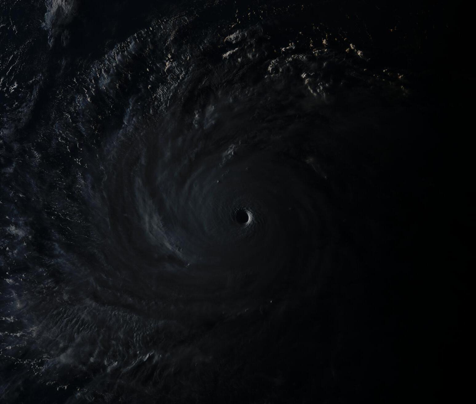
SUPER TYPHOON 25W (JEBI), LOCATED APPROXIMATELY 253 NM NORTHWEST
OF SAIPAN, HAS TRACKED WEST-NORTHWESTWARD AT 14 KNOTS OVER THE PAST
SIX HOURS. ANIMATED ENHANCED INFRARED SATELLITE IMAGERY DEPICTS A
COMPACT SYSTEM, APPROXIMATELY 145NM DIAMETER CENTRAL DENSE
OVERCAST, WITH A 15NM ROUND EYE. THE INITIAL INTENSITY IS ASSESSED
AT 150 KNOTS,BETWEEN THE PGTW DVORAK CURRENT INTENSITY ESTIMATE OF
T7.5 (155 KNOTS), THE RJTD/KNES ESTIMATES OF T7.0 (140 KTS), AND A
310331Z SATCON ESTIMATE OF 142 KNOTS. A 310721Z GMI 36GHZ COLOR
COMPOSITE IMAGE INDICATES AN EYEWALL REPLACEMENT CYCLE IS ONGOING,
WITH TWO EYEWALLS PRESENT AND A MOAT OF SUBSIDENCE BETWEEN THEM.
UPPER-LEVEL ANALYSIS REVEALS A VERY FAVORABLE ENVIRONMENT WITH LOW
VERTICAL WIND SHEAR, RADIAL OUTFLOW ENHANCED BY A TUTT CELL TO THE
EAST, WARM SSTS (29-31 C) AND HIGH OCEAN HEAT CONTENT VALUES, THAT
HAVE PERMITTED STY 25W TO RAPIDLY INTENSIFY OVER THE PAST SEVERAL
DAYS. STY 25W IS TRACKING ALONG THE SOUTHERN PERIPHERY OF AN EAST-
WEST ORIENTED SUBTROPICAL RIDGE (STR).
3. FORECAST REASONING.
A. THERE IS NO CHANGE TO THE FORECAST PHILOSOPHY FROM THE
PREVIOUS WARNING.
B. STY 25W WILL CONTINUE TO TRACK WESTWARD TO WEST-NORTHWESTWARD
THROUGH TAU 24 THEN WILL TURN NORTHWESTWARD TO NORTH-NORTHWESTWARD
ALONG THE WESTERN PERIPHERY OF THE STR THROUGH TAU 72. NUMERICAL
MODEL GUIDANCE IS IN GOOD AGREEMENT THROUGH TAU 72 WITH A SPREAD OF
235 NM AT TAU 72. BASED ON THE LOW UNCERTAINTY IN THE TRACK
GUIDANCE, CONFIDENCE IN THIS PORTION OF THE JTWC TRACK FORECAST IS
HIGH. ENVIRONMENTAL CONDITIONS ARE FORECAST TO REMAIN VERY
FAVORABLE THROUGH TAU 48, THEREFORE, THE SYSTEM WILL MAINTAIN SUPER
TYPHOON INTENSITY UNTIL TAU 48. HOWEVER, DUE TO THE EYEWALL
REPLACEMENT CYCLE, SHORT-TERM INTENSITY FLUCTUATIONS ARE POSSIBLE,
AND THERE IS SOME UNCERTAINTY IN THE JTWC INTENSITY FORECAST
THROUGH TAU 72. ONCE THE PRIMARY EYEWALL IS STARVED OF INFLOW AND
DISSIPATES, INTENSITY IS EXPECTED TO WEAKEN SLIGHTLY, BUT THEN AS
THE SECONDARY EYEWALL DOMINATES, BECOMES THE NEW PRIMARY EYEWALL,
AND CONTRACTS, THE SYSTEM MAY INTENSIFY ONCE AGAIN.
C. AFTER TAU 72, STY 25W WILL ACCELERATE NORTHWARD TO NORTH-
NORTHEASTWARD TOWARD CENTRAL HONSHU AS IT ROUNDS THE STR AXIS. STY
25W WILL GRADUALLY WEAKEN AS A WARM-CORE TROPICAL SYSTEM BEFORE TAU
96 DUE TO AN INCREASINGLY UNFAVORABLE ENVIRONMENT WITH LOWER OCEAN
HEAT CONTENT AND HIGHER VERTICAL WIND SHEAR. STY 25W IS EXPECTED TO
BEGIN EXTRA-TROPICAL TRANSITION (ETT) BY TAU 96 AS IT BEGINS TO
INTERACT WITH A DEEP MIDLATITUDE SHORTWAVE TROUGH DIGGING INTO THE
KOREAN PENINSULA AND WESTERN JAPAN, WHICH WILL TEMPORARILY ENHANCE
OUTFLOW. STY 25W WILL RAPIDLY COMPLETE ETT AS IT BECOMES EMBEDDED
WITHIN THE MIDLATITUDE SHORTWAVE TROUGH AND GAINS FRONTAL
CHARACTERISTICS OVER THE SEA OF JAPAN. THE SYSTEM WILL RAPIDLY
WEAKEN AFTER TAU 96 DUE TO INCREASING VERTICAL WIND SHEAR, COLDER
SSTS IN THE SEA OF JAPAN, AND INCREASED FRICTIONAL EFFECTS FROM
JAPAN. AFTER COMPLETING ETT, THE OCCLUDING EXTRA-TROPICAL LOW IS
FORECAST TO MAINTAIN STORM-FORCE WINDS AND THE WIND FIELD IS
FORECAST TO BECOME MORE EXPANSIVE AND ASYMMETRIC AS IT TRACKS
POLEWARD. MODELS STILL DEPICT SOME VARIATION IN TIMING AND SPEED OF
THE RECURVE AFTER TAU 72. THEREFORE, THERE IS LOW CONFIDENCE IN
THIS PORTION OF THE JTWC FORECAST TRACK.//
NNNN
MSGID/GENADMIN/JOINT TYPHOON WRNCEN PEARL HARBOR HI//
SUBJ/PROGNOSTIC REASONING FOR SUPER TYPHOON 25W (JEBI) WARNING NR
17//
RMKS/
1. FOR METEOROLOGISTS.
2. 6 HOUR SUMMARY AND ANALYSIS.
SUPER TYPHOON 25W (JEBI), LOCATED APPROXIMATELY 253 NM NORTHWEST
OF SAIPAN, HAS TRACKED WEST-NORTHWESTWARD AT 14 KNOTS OVER THE PAST
SIX HOURS. ANIMATED ENHANCED INFRARED SATELLITE IMAGERY DEPICTS A
COMPACT SYSTEM, APPROXIMATELY 145NM DIAMETER CENTRAL DENSE
OVERCAST, WITH A 15NM ROUND EYE. THE INITIAL INTENSITY IS ASSESSED
AT 150 KNOTS,BETWEEN THE PGTW DVORAK CURRENT INTENSITY ESTIMATE OF
T7.5 (155 KNOTS), THE RJTD/KNES ESTIMATES OF T7.0 (140 KTS), AND A
310331Z SATCON ESTIMATE OF 142 KNOTS. A 310721Z GMI 36GHZ COLOR
COMPOSITE IMAGE INDICATES AN EYEWALL REPLACEMENT CYCLE IS ONGOING,
WITH TWO EYEWALLS PRESENT AND A MOAT OF SUBSIDENCE BETWEEN THEM.
UPPER-LEVEL ANALYSIS REVEALS A VERY FAVORABLE ENVIRONMENT WITH LOW
VERTICAL WIND SHEAR, RADIAL OUTFLOW ENHANCED BY A TUTT CELL TO THE
EAST, WARM SSTS (29-31 C) AND HIGH OCEAN HEAT CONTENT VALUES, THAT
HAVE PERMITTED STY 25W TO RAPIDLY INTENSIFY OVER THE PAST SEVERAL
DAYS. STY 25W IS TRACKING ALONG THE SOUTHERN PERIPHERY OF AN EAST-
WEST ORIENTED SUBTROPICAL RIDGE (STR).
3. FORECAST REASONING.
A. THERE IS NO CHANGE TO THE FORECAST PHILOSOPHY FROM THE
PREVIOUS WARNING.
B. STY 25W WILL CONTINUE TO TRACK WESTWARD TO WEST-NORTHWESTWARD
THROUGH TAU 24 THEN WILL TURN NORTHWESTWARD TO NORTH-NORTHWESTWARD
ALONG THE WESTERN PERIPHERY OF THE STR THROUGH TAU 72. NUMERICAL
MODEL GUIDANCE IS IN GOOD AGREEMENT THROUGH TAU 72 WITH A SPREAD OF
235 NM AT TAU 72. BASED ON THE LOW UNCERTAINTY IN THE TRACK
GUIDANCE, CONFIDENCE IN THIS PORTION OF THE JTWC TRACK FORECAST IS
HIGH. ENVIRONMENTAL CONDITIONS ARE FORECAST TO REMAIN VERY
FAVORABLE THROUGH TAU 48, THEREFORE, THE SYSTEM WILL MAINTAIN SUPER
TYPHOON INTENSITY UNTIL TAU 48. HOWEVER, DUE TO THE EYEWALL
REPLACEMENT CYCLE, SHORT-TERM INTENSITY FLUCTUATIONS ARE POSSIBLE,
AND THERE IS SOME UNCERTAINTY IN THE JTWC INTENSITY FORECAST
THROUGH TAU 72. ONCE THE PRIMARY EYEWALL IS STARVED OF INFLOW AND
DISSIPATES, INTENSITY IS EXPECTED TO WEAKEN SLIGHTLY, BUT THEN AS
THE SECONDARY EYEWALL DOMINATES, BECOMES THE NEW PRIMARY EYEWALL,
AND CONTRACTS, THE SYSTEM MAY INTENSIFY ONCE AGAIN.
C. AFTER TAU 72, STY 25W WILL ACCELERATE NORTHWARD TO NORTH-
NORTHEASTWARD TOWARD CENTRAL HONSHU AS IT ROUNDS THE STR AXIS. STY
25W WILL GRADUALLY WEAKEN AS A WARM-CORE TROPICAL SYSTEM BEFORE TAU
96 DUE TO AN INCREASINGLY UNFAVORABLE ENVIRONMENT WITH LOWER OCEAN
HEAT CONTENT AND HIGHER VERTICAL WIND SHEAR. STY 25W IS EXPECTED TO
BEGIN EXTRA-TROPICAL TRANSITION (ETT) BY TAU 96 AS IT BEGINS TO
INTERACT WITH A DEEP MIDLATITUDE SHORTWAVE TROUGH DIGGING INTO THE
KOREAN PENINSULA AND WESTERN JAPAN, WHICH WILL TEMPORARILY ENHANCE
OUTFLOW. STY 25W WILL RAPIDLY COMPLETE ETT AS IT BECOMES EMBEDDED
WITHIN THE MIDLATITUDE SHORTWAVE TROUGH AND GAINS FRONTAL
CHARACTERISTICS OVER THE SEA OF JAPAN. THE SYSTEM WILL RAPIDLY
WEAKEN AFTER TAU 96 DUE TO INCREASING VERTICAL WIND SHEAR, COLDER
SSTS IN THE SEA OF JAPAN, AND INCREASED FRICTIONAL EFFECTS FROM
JAPAN. AFTER COMPLETING ETT, THE OCCLUDING EXTRA-TROPICAL LOW IS
FORECAST TO MAINTAIN STORM-FORCE WINDS AND THE WIND FIELD IS
FORECAST TO BECOME MORE EXPANSIVE AND ASYMMETRIC AS IT TRACKS
POLEWARD. MODELS STILL DEPICT SOME VARIATION IN TIMING AND SPEED OF
THE RECURVE AFTER TAU 72. THEREFORE, THERE IS LOW CONFIDENCE IN
THIS PORTION OF THE JTWC FORECAST TRACK.//
NNNN
0 likes
-
1900hurricane

- Category 5
- Posts: 6063
- Age: 34
- Joined: Fri Feb 06, 2015 12:04 pm
- Location: Houston, TX
- Contact:
Re: WPAC: JEBI - Typhoon
I guess the flip side of every AMSU pass hitting yesterday is that none are today...
0 likes
Contract Meteorologist. TAMU & MSST. Fiercely authentic, one of a kind. We are all given free will, so choose a life meant to be lived. We are the Masters of our own Stories.
Opinions expressed are mine alone.
Follow me on Twitter at @1900hurricane : Read blogs at https://1900hurricane.wordpress.com/
Opinions expressed are mine alone.
Follow me on Twitter at @1900hurricane : Read blogs at https://1900hurricane.wordpress.com/

-
euro6208
Re: WPAC: JEBI - Typhoon
CIMSS/NESDIS-USAF/NRL AMSU TC Intensity Estimation:
SUPER TYPHOON 25W
Thursday 30aug18 Time: 2241 UTC
Latitude: 17.85 Longitude: 144.68
Storm position corresponds to AMSU-A FOV 13 [1<--->30]
-----------------------------------------------------------------
| Estimated MSLP: 914 hPa
| Estimated Maximum Sustained Wind: 156 kts
| Estimate Confidence: Good ( +/- 10mb +/- 12kts )
-----------------------------------------------------------------
Storm is sub-sampled: Bias correction applied is -18.3 hPa
Channel 8 (~150 hPa) Tb Anomaly: 4.43
Channel 7 (~250 hPa) Tb Anomaly: 4.04
RMW: 9 km
RMW Source is: MW
Environmental Pressure: 1007
Satellite: NOAA-18
ATCF data for Month: 08 Day: 31 Time (UTC): 0000
For imagery, go to http://amsu.ssec.wisc.edu
For all comments and questions mailto:chrisv@ssec.wisc.edu
0 likes
-
doomhaMwx
- Category 5
- Posts: 2487
- Age: 27
- Joined: Tue Apr 18, 2017 4:01 am
- Location: Baguio/Benguet, Philippines
- Contact:
Re: WPAC: JEBI - Typhoon
RGB satellite animation of STY Jebi from sunrise to sunset today.
(May take quite long to load due to large file size)

https://s1.gifyu.com/images/latest.gif
(May take quite long to load due to large file size)
https://s1.gifyu.com/images/latest.gif
3 likes

Re: WPAC: JEBI - Typhoon

0 likes
Very useful information on the Dvorak Technique --
https://severe.worldweather.wmo.int/TCF ... kBeven.pdf
https://severe.worldweather.wmo.int/TCF ... kBeven.pdf
Re: WPAC: JEBI - Typhoon
12z best track down to 910 mb, still 150 kts
0 likes
Very useful information on the Dvorak Technique --
https://severe.worldweather.wmo.int/TCF ... kBeven.pdf
https://severe.worldweather.wmo.int/TCF ... kBeven.pdf
-
mrbagyo

- Category 5
- Posts: 3963
- Age: 33
- Joined: Thu Apr 12, 2012 9:18 am
- Location: 14.13N 120.98E
- Contact:
Re: WPAC: JEBI - Typhoon
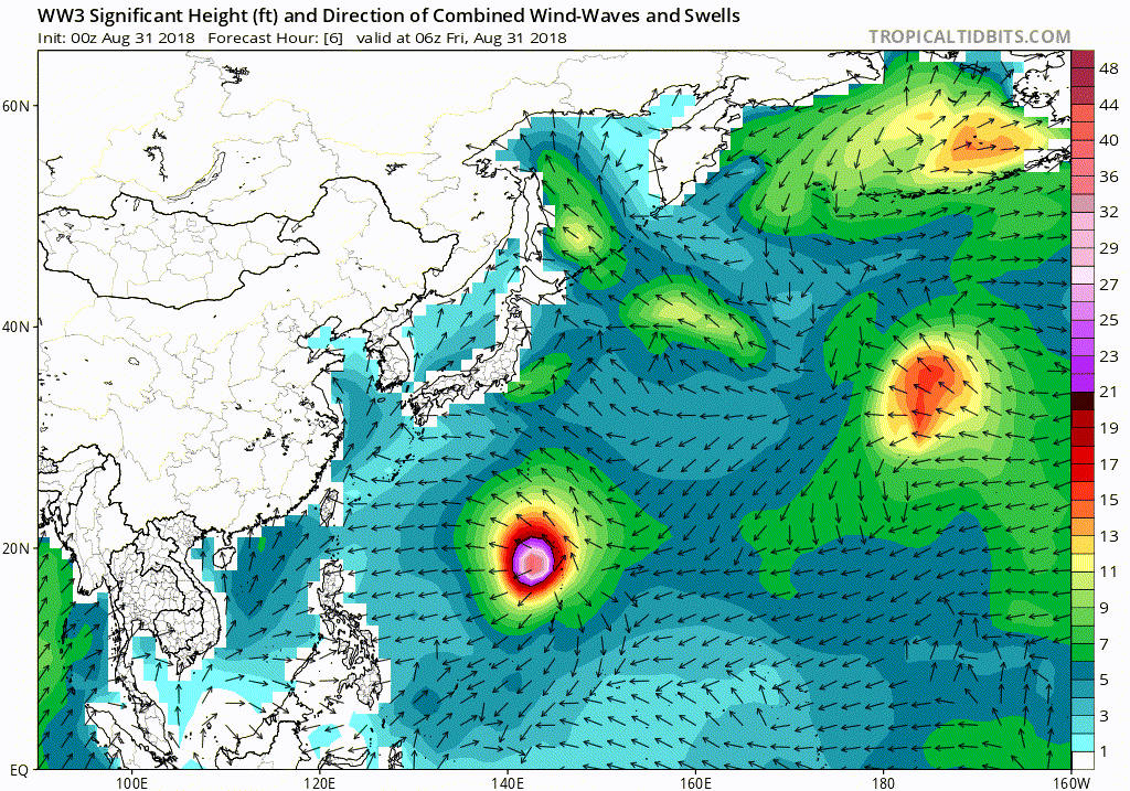
The surge risk is real.
0 likes
The posts in this forum are NOT official forecast and should not be used as such. They are just the opinion of the poster and may or may not be backed by sound meteorological data. They are NOT endorsed by any professional institution or storm2k.org. For official information, please refer to RSMC, NHC and NWS products.
-
euro6208
Re: WPAC: JEBI - Typhoon
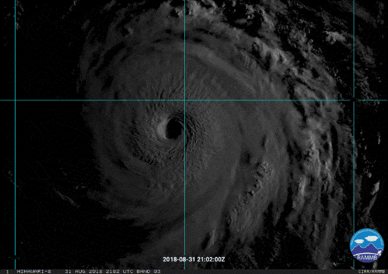
Fourth straight 7.5...
TPPN10 PGTW 311221
A. SUPER TYPHOON 25W (JEBI)
B. 31/1150Z
C. 18.57N
D. 141.44E
E. ONE/HMWRI8
F. T7.5/7.5/D1.0/24HRS STT: S0.0/03HRS
G. IR/EIR
H. REMARKS: 01A/PBO EYE/ANMTN. WMG EYE SURROUNDED BY W YIELDS
AN E# OF 6.0. ADDED 1.0 FOR EYE ADJUSTMENT TO YIELD A DT OF
7.0, ADDED 0.5 FOR BF RESULTING IN DT OF 7.5. MET AND PT AGREE.
DBO DT.
I. ADDITIONAL POSITIONS:
31/0721Z 18.32N 142.45E GPMI
31/0832Z 18.30N 142.22E SSMS
31/0851Z 18.33N 142.18E WIND
VEERKAMP
0 likes
-
mrbagyo
- Category 5
- Posts: 3963
- Age: 33
- Joined: Thu Apr 12, 2012 9:18 am
- Location: 14.13N 120.98E
- Contact:
Re: WPAC: JEBI - Typhoon
Going downhill.
0 likes
The posts in this forum are NOT official forecast and should not be used as such. They are just the opinion of the poster and may or may not be backed by sound meteorological data. They are NOT endorsed by any professional institution or storm2k.org. For official information, please refer to RSMC, NHC and NWS products.
-
1900hurricane
- Category 5
- Posts: 6063
- Age: 34
- Joined: Fri Feb 06, 2015 12:04 pm
- Location: Houston, TX
- Contact:
Re: WPAC: JEBI - Typhoon
Looks like eyewall replacement. I don’t think this one will take too long though.
0 likes
Contract Meteorologist. TAMU & MSST. Fiercely authentic, one of a kind. We are all given free will, so choose a life meant to be lived. We are the Masters of our own Stories.
Opinions expressed are mine alone.
Follow me on Twitter at @1900hurricane : Read blogs at https://1900hurricane.wordpress.com/
Opinions expressed are mine alone.
Follow me on Twitter at @1900hurricane : Read blogs at https://1900hurricane.wordpress.com/
-
Cunxi Huang

- Category 1

- Posts: 329
- Age: 27
- Joined: Thu Sep 26, 2013 12:17 pm
- Location: San Jose, CA
- Contact:
Re: WPAC: JEBI - Typhoon


Well looks like Jebi just completed one ERC. But recent 36ghz also suggest a strong rain band which could turn into an outer eyewall later on.
0 likes
06 SuTY SAOMAI | 09 TY LINFA | 10 TY FANAPI | 10 SuTY MEGI | 16 SuTY MERANTI | 19 SuTY LEKIMA | 24 C2 FRANCINE
DO NOT use my posts for life and death decisions. For official information, please refer to products from your RSMC and national weather agency.
DO NOT use my posts for life and death decisions. For official information, please refer to products from your RSMC and national weather agency.
-
cycloneye

- Admin

- Posts: 149368
- Age: 69
- Joined: Thu Oct 10, 2002 10:54 am
- Location: San Juan, Puerto Rico
Re: WPAC: JEBI - Typhoon

0 likes
Visit the Caribbean-Central America Weather Thread where you can find at first post web cams,radars
and observations from Caribbean basin members Click Here
and observations from Caribbean basin members Click Here
-
mrbagyo
- Category 5
- Posts: 3963
- Age: 33
- Joined: Thu Apr 12, 2012 9:18 am
- Location: 14.13N 120.98E
- Contact:
Re: WPAC: JEBI - Typhoon
0 likes
The posts in this forum are NOT official forecast and should not be used as such. They are just the opinion of the poster and may or may not be backed by sound meteorological data. They are NOT endorsed by any professional institution or storm2k.org. For official information, please refer to RSMC, NHC and NWS products.
Who is online
Users browsing this forum: No registered users and 78 guests