Tropical Wave over the SE Bahamas (Is INVEST 91L)
Moderator: S2k Moderators
Forum rules

The posts in this forum are NOT official forecasts and should not be used as such. They are just the opinion of the poster and may or may not be backed by sound meteorological data. They are NOT endorsed by any professional institution or STORM2K. For official information, please refer to products from the National Hurricane Center and National Weather Service.
-
Clearcloudz

- Category 2

- Posts: 540
- Joined: Sun Jun 10, 2018 1:46 pm
- Location: Rosenberg TX
Re: Tropical Wave in Central Caribbean / West Atlantic
NHC should start raising chances of this system as well as start running more high resolution models because one key thing that the ECMWF ensembles show that the operational doesn't is some members keep this over the water as the high ridge builds in (depending on how fast it builds in and how fast the system moves). Any slow down of a system in the gulf of mexico has trouble written all over it.
1 likes
-
AJC3

- Admin

- Posts: 4153
- Age: 62
- Joined: Tue Aug 31, 2004 7:04 pm
- Location: Ballston Spa, New York
- Contact:
Re: Tropical Wave in the Turks & Caicos/SE Bahamas
...TROPICAL WAVES...
A central Caribbean tropical wave extends its axis from west
Hispaniola near 20N73W to N Colombia near 09N75W, moving west at
10 kt. This wave was repositioned based on satellite imagery, low-
level TPW imagery, and model guidance. This wave is in an area
where an upper-level low prevails, centered near 17N74W. With
these, scattered moderate convection prevails north of 17N between
67W-75W, affecting eastern Cuba, Windward Passage, Hispaniola,
and the Mona Passage.
ATLANTIC OCEAN...
An upper level low is centered north of the Bahamas near 29N77W.
THis feature is enhancing scattered moderate convection west of
75W. To the east, a surface trough has broken away from the
Caribbean's tropical wave and extends from 25N71W to 21N74W.
Scattered moderate convection prevails along this trough affecting
the southern Bahamas. This trough is moving WNW towards S Florida
and the Gulf of Mexico.
3 likes
-
cycloneye

- Admin
- Posts: 149374
- Age: 69
- Joined: Thu Oct 10, 2002 10:54 am
- Location: San Juan, Puerto Rico
Re: Tropical Wave in the Turks & Caicos/SE Bahamas
8 AM TWO up to 10%/40%

Tropical Weather Outlook
NWS National Hurricane Center Miami FL
800 AM EDT Sat Sep 1 2018
For the North Atlantic...Caribbean Sea and the Gulf of Mexico:
The National Hurricane Center is issuing advisories on recently
upgraded Tropical Storm Florence, located about a couple of hundred
miles west of the Cabo Verde Islands.
A tropical wave interacting with an upper-level trough is producing
numerous showers and thunderstorms from Hispaniola northward across
the Turks and Caicos Islands. This activity is forecast to spread
west-northwestward, enhancing rainfall across Hispaniola, the Turks
and Caicos Islands, the Bahamas this weekend, and across Florida
and the northern Gulf of Mexico coast by early next week. Strong
upper-level winds will likely prevent significant development of
this system during the next couple of days, but environmental
conditions are expected to become a little more favorable for a
surface low pressure area to form when the disturbance moves across
the Gulf of Mexico during the early to middle part of next week.
* Formation chance through 48 hours...low...10 percent.
* Formation chance through 5 days...medium...40 percent.
$$
Forecaster Avila
4 likes
Visit the Caribbean-Central America Weather Thread where you can find at first post web cams,radars
and observations from Caribbean basin members Click Here
and observations from Caribbean basin members Click Here
-
Hurricaneman

- Category 5

- Posts: 7404
- Age: 45
- Joined: Tue Aug 31, 2004 3:24 pm
- Location: central florida
Re: Tropical Wave in the Turks & Caicos/SE Bahamas: 8 AM TWO=10%/40%
Likely to be an invest later today and they’re getting ready for possible recon by sometime Monday one would think
0 likes
-
cycloneye
- Admin
- Posts: 149374
- Age: 69
- Joined: Thu Oct 10, 2002 10:54 am
- Location: San Juan, Puerto Rico
Re: Tropical Wave in the Turks & Caicos/SE Bahamas: 8 AM TWO=10%/40%
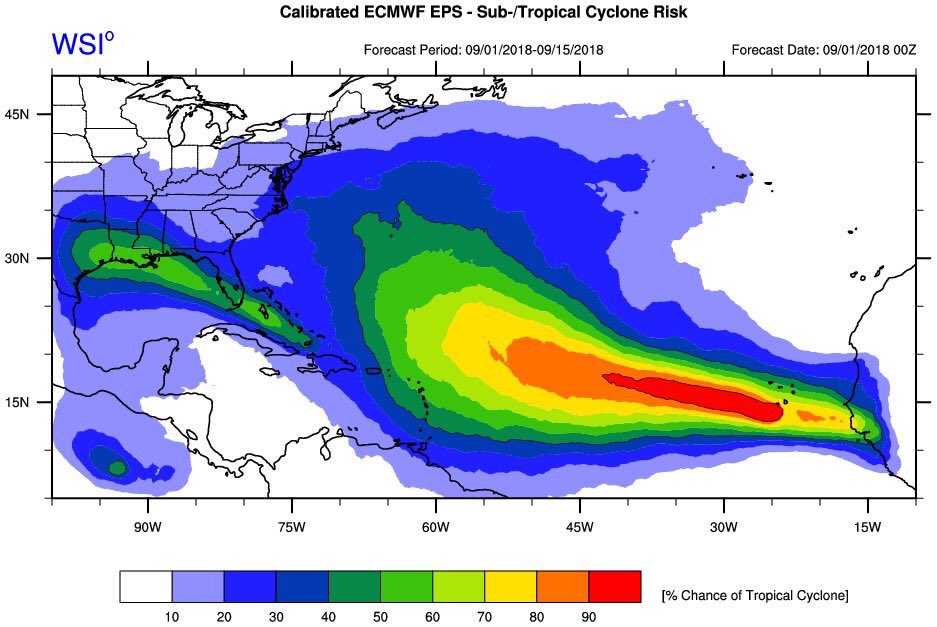
Look at the area the graphic that extends along all the Gulf Coast from Florida to Texas.
1 likes
Visit the Caribbean-Central America Weather Thread where you can find at first post web cams,radars
and observations from Caribbean basin members Click Here
and observations from Caribbean basin members Click Here
-
Clearcloudz
- Category 2
- Posts: 540
- Joined: Sun Jun 10, 2018 1:46 pm
- Location: Rosenberg TX
Re: Tropical Wave in the Turks & Caicos/SE Bahamas: 8 AM TWO=10%/40%
It appears Hispaniola fractured the wave into two pieces with the more significant vorticity energy now over the Turks/Caicos and the SE Bahamas, moving toward the Florida Keys/Straits. Mentioned in the NWS discussion.
A tropical wave is producing numerous showers and thunderstorms across Hispaniola and the Turks and Caicos Islands. Significant development is unlikely until this system moves into the Gulf of Mexico next week where it has a medium chance of becoming a tropical cyclone.
https://twitter.com/NHC_Atlantic/status/1035863308690182144
0 likes
Re: Tropical Wave in the Turks & Caicos/SE Bahamas: 8 AM TWO=10%/40%
What a dramatic change from August (yesterday).
4 likes
-
Hypercane_Kyle

- Category 5
- Posts: 3465
- Joined: Sat Mar 07, 2015 7:58 pm
- Location: Cape Canaveral, FL
Re: Tropical Wave in the Turks & Caicos/SE Bahamas: 8 AM TWO=10%/40%
Given the major shift in tone from the ECMWF on this run for both this system and Florence, I am almost tempted to call it a bad run. Certainly will be if the 12z ECMWF drops it again.
0 likes
My posts are my own personal opinion, defer to the National Hurricane Center (NHC) and other NOAA products for decision making during hurricane season.
-
Clearcloudz
- Category 2
- Posts: 540
- Joined: Sun Jun 10, 2018 1:46 pm
- Location: Rosenberg TX
Re: Tropical Wave in the Turks & Caicos/SE Bahamas
ABC13-Travis Herzog
Original Post link: https://www.facebook.com/TravisABC13/?fb_dtsg_ag=AdwRM0j6NEkPMbXF0cj4xiAYYYgOaVB-33ov_oWD4Fdc1A%3AAdzmFXVyvm9XtnYNK-STJ3SuD1BFiagOMQlDZAq1ExEaEg
7AM SATURDAY TROPICAL WEATHER UPDATE
Odds are increasing that the Gulf coast will be dealing with at least a tropical depression or storm named Gordon next week. In the last 24 hours there have been two significant changes to the 5 day outlook for the Gulf of Mexico:
1.) First, the odds of a tropical depression or storm forming by Thursday have now increased to 40%.
2.) Second, the formation zone (and pathway of the potential system) has expanded westward toward Texas.
More than anything, this is just reflecting the fact that the 5 day outlook now extends one day further into next week.
None of this is surprising to me. All week long our guidance has been indicating that the environment would be more conducive for tropical formation toward the end of next week and that the system would track close to Louisiana and Texas by then.
The tropical disturbance, now north of Haiti, is still disorganized. It still may never develop. Regardless of development, it will bring heavy, flooding rains to Florida and elsewhere along the Gulf coast.
While we all hope for the best, we all know how quickly the Gulf can spin up storms. It would be wise to stay informed and aware now that we're in peak hurricane season. I'd recommend checking in daily on what's happening in the tropics as you go about your normal plans this Labor Day weekend. While I'm away from work, I'll continue to keep you updated here on Facebook once or twice daily. Stay tuned.
0 likes

Re: Tropical Wave in the Turks & Caicos/SE Bahamas
Time for this TW be declared an Invest this morning, a significant increase in the number of Euro ensembles are developing it, around 38 out of 50 to be exact.

3 likes
-
Clearcloudz
- Category 2
- Posts: 540
- Joined: Sun Jun 10, 2018 1:46 pm
- Location: Rosenberg TX
-
jlauderdal
- S2K Supporter

- Posts: 7240
- Joined: Wed May 19, 2004 5:46 am
- Location: NE Fort Lauderdale
- Contact:
Re: Tropical Wave in the Turks & Caicos/SE Bahamas: 8 AM TWO=10%/40%
ForexTidbits wrote:It appears Hispaniola fractured the wave into two pieces with the more significant vorticity energy now over the Turks/Caicos and the SE Bahamas, moving toward the Florida Keys/Straits. Mentioned in the NWS discussion.
A tropical wave is producing numerous showers and thunderstorms across Hispaniola and the Turks and Caicos Islands. Significant development is unlikely until this system moves into the Gulf of Mexico next week where it has a medium chance of becoming a tropical cyclone.
https://twitter.com/NHC_Atlantic/status/1035863308690182144
the shredder in action
1 likes
-
jlauderdal
- S2K Supporter
- Posts: 7240
- Joined: Wed May 19, 2004 5:46 am
- Location: NE Fort Lauderdale
- Contact:
Re: Tropical Wave north of Hispañola
as usual its all about the shear, water temps are goodtolakram wrote:I wonder what the key is for development vs not? If this happens then yet another example of no clear signal (development or intensity) until less than 5 days away.
0 likes
Re: Tropical Wave in the Turks & Caicos/SE Bahamas: 8 AM TWO=10%/40%
jlauderdal wrote:the shredder in action
in this case there's nothing to shred, if anything is concentrating the energy toward the turks/caicos.
1 likes
-
Clearcloudz
- Category 2
- Posts: 540
- Joined: Sun Jun 10, 2018 1:46 pm
- Location: Rosenberg TX
Re: Tropical Wave in the Turks & Caicos/SE Bahamas: 8 AM TWO=10%/40%
BobHarlem wrote:jlauderdal wrote:the shredder in action
in this case there's nothing to shred, if anything is concentrating the energy toward the turks/caicos.
The island of Hispaniola is known to doing strange things when it comes to tropical cyclones.
0 likes
-
MississippiWx

- S2K Supporter
- Posts: 1720
- Joined: Sat Aug 14, 2010 1:44 pm
- Location: Hattiesburg, Mississippi
Re: Tropical Wave in the Turks & Caicos/SE Bahamas
The GFS still shows a weaker cyclone, obviously, but I’ve been watching the depiction of the 850mb vort on the model. It has consistently gotten stronger, so it is seeing a stronger system even though it may not be reflecting it in the winds and pressure on the model yet. The FV3 had its strongest run of the system at 6z. The trend is your friend.
2 likes
This post is not an official forecast and should not be used as such. It is just the opinion of MississippiWx and may or may not be backed by sound meteorological data. It is not endorsed by any professional institution including storm2k.org. For Official Information please refer to the NHC and NWS products.
Re: Tropical Wave in the Turks & Caicos/SE Bahamas
I would remove the pasted statement from the local TV (ABC13) met, because what you're reading there is "keep watching" script, having worked in the weather business.
The wave/disturbance is being sheared completely by the trough/ULL to it's west, and the reason NHC does not expect any development until it reaches the GOM, if anything.
The wave/disturbance is being sheared completely by the trough/ULL to it's west, and the reason NHC does not expect any development until it reaches the GOM, if anything.
0 likes
-
jlauderdal
- S2K Supporter
- Posts: 7240
- Joined: Wed May 19, 2004 5:46 am
- Location: NE Fort Lauderdale
- Contact:
Re: Tropical Wave in the Turks & Caicos/SE Bahamas: 8 AM TWO=10%/40%
BobHarlem wrote:jlauderdal wrote:the shredder in action
in this case there's nothing to shred, if anything is concentrating the energy toward the turks/caicos.
sir, while there is no defined center it does appear hispaniola has caused a disruption, fracture, break, displacement or whatever you want to call it..we have seen hispaniola and eastern cuba do this many times to defined and ill defined systems.the upper levels weren't going to be conducive to development east of the conch republic, northern gulf and western gulf be ready
1 likes
-
jlauderdal
- S2K Supporter
- Posts: 7240
- Joined: Wed May 19, 2004 5:46 am
- Location: NE Fort Lauderdale
- Contact:
Re: Tropical Wave in the Turks & Caicos/SE Bahamas: 8 AM TWO=10%/40%
very true and dont leave it eastern cooba...whether a system goes over, south or north this area tends to have major implications including inflow issues...its been helpful to florida many timesForexTidbits wrote:BobHarlem wrote:jlauderdal wrote:the shredder in action
in this case there's nothing to shred, if anything is concentrating the energy toward the turks/caicos.
The island of Hispaniola is known to doing strange things when it comes to tropical cyclones.
1 likes
Re: Tropical Wave in the Turks & Caicos/SE Bahamas: 8 AM TWO=10%/40%
jlauderdal wrote:BobHarlem wrote:jlauderdal wrote:the shredder in action
in this case there's nothing to shred, if anything is concentrating the energy toward the turks/caicos.
sir, while there is no defined center it does appear hispaniola has caused a disruption, fracture, break, displacement or whatever you want to call it..we have seen hispaniola and eastern cuba do this many times to defined and ill defined systems.the upper levels weren't going to be conducive to development east of the conch republic, northern gulf and western gulf be ready
Disruptive, maybe, if anything was going. i think i understand what you are getting at though. it definitely scrambles it, although I think right around the inagua islands is where something is trying to happen at the moment (although that probably will shift because of those issues with Hispaniola/Cuba) It does slow it down.
Last edited by BobHarlem on Sat Sep 01, 2018 8:22 am, edited 1 time in total.
1 likes
Who is online
Users browsing this forum: No registered users and 144 guests