
Newest runs I can find:
HMON into St. Tammany Parish LA north of Lake Pontchartrain at about Slidell/Salt Bayou. Most of the weather is along the MS and AL Gulf Coast. Landfall around midnight tomorrow.
https://www.tropicaltidbits.com/analysi ... 0306&fh=48
NAM 12z landfall around the MS Gulf Coastaround midnight tomorrow.
https://www.tropicaltidbits.com/analysi ... 0312&fh=42
06z RGEM landfalls MS Gulf Coast tomorrow around 9 or 10. More defined than HMON or NAM.
https://www.tropicaltidbits.com/analysi ... 0306&fh=44
ATL: GORDON - Models
Moderator: S2k Moderators
Re: ATL: GORDON - Models
1 likes
-
tolakram
- Admin

- Posts: 20183
- Age: 62
- Joined: Sun Aug 27, 2006 8:23 pm
- Location: Florence, KY (name is Mark)
Re: ATL: GORDON - Models
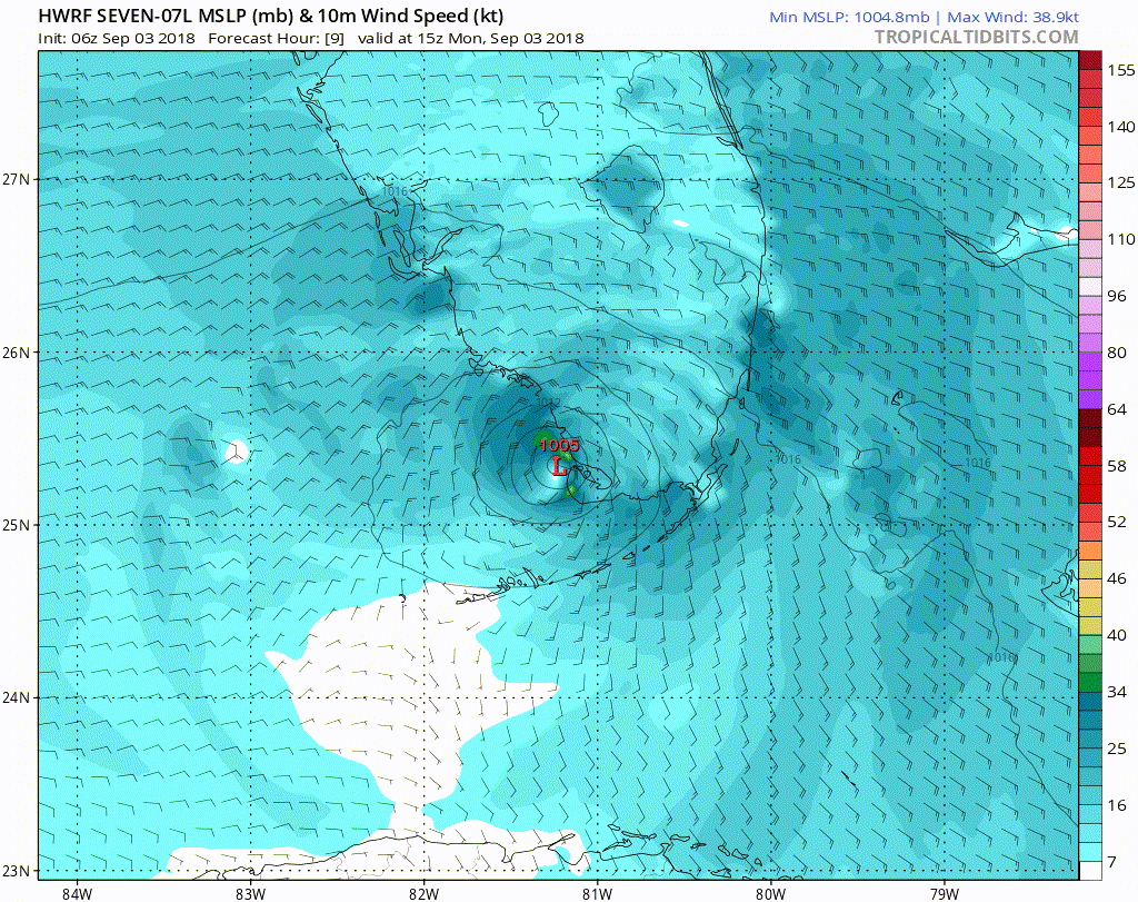
The 6Z HWRF looks like it has a pretty good track. Starting at hour 9.
0 likes
M a r k
- - - - -
Join us in chat: Storm2K Chatroom Invite. Android and IOS apps also available.
The posts in this forum are NOT official forecasts and should not be used as such. Posts are NOT endorsed by any professional institution or STORM2K.org. For official information and forecasts, please refer to NHC and NWS products.
-
jlauderdal
- S2K Supporter

- Posts: 7240
- Joined: Wed May 19, 2004 5:46 am
- Location: NE Fort Lauderdale
- Contact:

Re: ATL: GORDON - Models
tolakram wrote:The 6Z HWRF looks like it has a pretty good track. Starting at hour 9.
Much further east shift than previous runs. I know with that ridge in place, it can't move much further east.
0 likes
Personal Forecast Disclaimer:
The posts in this forum are NOT official forecast and should not be used as such. They are just the opinion of the poster and may or may not be backed by sound meteorological data. They are NOT endorsed by any professional institution or storm2k.org. For official information, please refer to the NHC and NWS products.
The posts in this forum are NOT official forecast and should not be used as such. They are just the opinion of the poster and may or may not be backed by sound meteorological data. They are NOT endorsed by any professional institution or storm2k.org. For official information, please refer to the NHC and NWS products.
-
Frank P
- S2K Supporter
- Posts: 2779
- Joined: Fri Aug 29, 2003 10:52 am
- Location: Biloxi Beach, Ms
- Contact:
Re: ATL: GORDON - Models
SoupBone wrote:tolakram wrote:The 6Z HWRF looks like it has a pretty good track. Starting at hour 9.
Much further east shift than previous runs. I know with that ridge in place, it can't move much further east.
But at H45 the 06Z (Bay St Louis) is much to the west than the 0Z (Ocean Springs)
1 likes
-
MississippiWx

- S2K Supporter
- Posts: 1720
- Joined: Sat Aug 14, 2010 1:44 pm
- Location: Hattiesburg, Mississippi
Re: ATL: GORDON - Models
The GFS is pure trash. Doesn’t even have this as a closed circulation ever.
4 likes
This post is not an official forecast and should not be used as such. It is just the opinion of MississippiWx and may or may not be backed by sound meteorological data. It is not endorsed by any professional institution including storm2k.org. For Official Information please refer to the NHC and NWS products.
Re: ATL: GORDON - Models
MississippiWx wrote:The GFS is pure trash. Doesn’t even have this as a closed circulation ever.
What's the window where the Hurricane Models perform much better? Is it 48 hours?
0 likes
Personal Forecast Disclaimer:
The posts in this forum are NOT official forecast and should not be used as such. They are just the opinion of the poster and may or may not be backed by sound meteorological data. They are NOT endorsed by any professional institution or storm2k.org. For official information, please refer to the NHC and NWS products.
The posts in this forum are NOT official forecast and should not be used as such. They are just the opinion of the poster and may or may not be backed by sound meteorological data. They are NOT endorsed by any professional institution or storm2k.org. For official information, please refer to the NHC and NWS products.
Re: ATL: GORDON - Models
CMC back to old EC solution with track at 12z hitting SELA at midnight tomorrow.
https://www.tropicaltidbits.com/analysi ... 0312&fh=42
https://www.tropicaltidbits.com/analysi ... 0312&fh=42
0 likes
Re: ATL: GORDON - Models
HMON 12z @ about Harrison County, MS tomorrow around 7pm.
https://www.tropicaltidbits.com/analysi ... 0312&fh=36
https://www.tropicaltidbits.com/analysi ... 0312&fh=36
0 likes
Re: ATL: GORDON - Models
WRF-P about the same as HMON.
https://www.tropicaltidbits.com/analysi ... 0306&fh=42
RGEM is about the same as CMC which you’d expect because it’s part of the CMC. Landfall Eastern St. Tammany Parish 11:00pm tomorrow
https://www.tropicaltidbits.com/analysi ... 0312&fh=40
https://www.tropicaltidbits.com/analysi ... 0306&fh=42
RGEM is about the same as CMC which you’d expect because it’s part of the CMC. Landfall Eastern St. Tammany Parish 11:00pm tomorrow
https://www.tropicaltidbits.com/analysi ... 0312&fh=40
0 likes
Re: ATL: GORDON - Models
FV-3 GFS La/MS border around midnight.
https://www.tropicaltidbits.com/analysi ... 0312&fh=42
https://www.tropicaltidbits.com/analysi ... 0312&fh=42
0 likes
Re: ATL: GORDON - Models
ICON has nothing even at 500mb.
https://www.tropicaltidbits.com/analysi ... 1412&fh=45
https://www.tropicaltidbits.com/analysi ... 1412&fh=45
0 likes

Re: ATL: GORDON - Models
Steve wrote:ICON has nothing even at 500mb.
https://www.tropicaltidbits.com/analysi ... 1412&fh=45
Hasn't updated since August 14th lol
5 likes
Re: ATL: GORDON - Models
storm4u wrote:Steve wrote:ICON has nothing even at 500mb.
https://www.tropicaltidbits.com/analysi ... 1412&fh=45
Hasn't updated since August 14th lol
Probably for the best. Haha
3 likes
-
AtlanticWind

- S2K Supporter
- Posts: 1898
- Age: 67
- Joined: Sun Aug 08, 2004 9:57 pm
- Location: Plantation,Fla

Re: ATL: GORDON - Models
IMHO ... Sit up and take notice western FL panhandle ... 
0 likes
Just then the wind came squalling through the door,
But who can the weather command?
But who can the weather command?
-
SunnyThoughts
- Category 5

- Posts: 2263
- Joined: Wed Jul 09, 2003 12:42 pm
- Location: Pensacola, Florida
Re: ATL: GORDON - Models
pcbjr wrote:IMHO ... Sit up and take notice western FL panhandle ...
Definitely taking notice here. Preps all in place just in case.
1 likes
-
tolakram
- Admin
- Posts: 20183
- Age: 62
- Joined: Sun Aug 27, 2006 8:23 pm
- Location: Florence, KY (name is Mark)
Re: ATL: GORDON - Models
12Z Euro

2 likes
M a r k
- - - - -
Join us in chat: Storm2K Chatroom Invite. Android and IOS apps also available.
The posts in this forum are NOT official forecasts and should not be used as such. Posts are NOT endorsed by any professional institution or STORM2K.org. For official information and forecasts, please refer to NHC and NWS products.
- - - - -
Join us in chat: Storm2K Chatroom Invite. Android and IOS apps also available.
The posts in this forum are NOT official forecasts and should not be used as such. Posts are NOT endorsed by any professional institution or STORM2K.org. For official information and forecasts, please refer to NHC and NWS products.
Re: ATL: GORDON - Models
Yeah. If the EC is right, it’s going to be on the western edge of the guidance. You can see the high very well on visible and wv. Pushing from the east and down from the NE and N
https://www.tropicaltidbits.com/sat/sat ... uct=wv-mid
https://www.tropicaltidbits.com/sat/sat ... uct=wv-mid
1 likes
Who is online
Users browsing this forum: No registered users and 22 guests