ATL: FLORENCE - Models
Moderator: S2k Moderators
-
Hurricaneman

- Category 5

- Posts: 7404
- Age: 45
- Joined: Tue Aug 31, 2004 3:24 pm
- Location: central florida
Re: ATL: FLORENCE - Models
The 18zGFS is verifying wrong on pressure, has 995 at initialization
0 likes

Re: ATL: FLORENCE - Models
That would be a pretty remarkable track. I'll continue to predict something in the middle of the Euro and GFS...e.g. between Bermuda and the East Coast.
0 likes
-
OuterBanker
- S2K Supporter

- Posts: 1761
- Joined: Wed Feb 26, 2003 10:53 am
- Location: Nags Head, NC
- Contact:
Re: ATL: FLORENCE - Models
Pretty remarkable day at the beach. Both air and water the same low to mid 80's. Shore break 2 to 3 ft. Perfect day and one of the reasons I live here. But, it seems even better news that the modeling is moving away from us. I knew that 10 days out is hardly ever correct.
0 likes
-
Hypercane_Kyle

- Category 5
- Posts: 3465
- Joined: Sat Mar 07, 2015 7:58 pm
- Location: Cape Canaveral, FL
Re: ATL: FLORENCE - Models
18z GFS almost directly ontop of the ECMWF at 90 hours, but they differ quite a bit on strength. The GFS simply doesn't see Florence weakening like the ECMWF does.
0 likes
My posts are my own personal opinion, defer to the National Hurricane Center (NHC) and other NOAA products for decision making during hurricane season.
-
Hurricaneman
- Category 5
- Posts: 7404
- Age: 45
- Joined: Tue Aug 31, 2004 3:24 pm
- Location: central florida
Re: ATL: FLORENCE - Models
Hypercane_Kyle wrote:18z GFS almost directly ontop of the ECMWF at 90 hours, but they differ quite a bit on strength. The GFS simply doesn't see Florence weakening like the ECMWF does.
But the strength this run isn’t completely ridiculous, the pressure is a little lower than what i expect but not in the 960s like the 12z
0 likes
-
TropicalAnalystwx13

- Category 5
- Posts: 2109
- Age: 28
- Joined: Tue Jul 19, 2011 8:20 pm
- Location: Wilmington, NC
- Contact:
Re: ATL: FLORENCE - Models
GFS has an intensifying hurricane when westerly winds are nearing 30kt.
No.
No.
2 likes
-
Hurricaneman
- Category 5
- Posts: 7404
- Age: 45
- Joined: Tue Aug 31, 2004 3:24 pm
- Location: central florida
Re: ATL: FLORENCE - Models
TropicalAnalystwx13 wrote:GFS has an intensifying hurricane when westerly winds are nearing 30kt.
No.
Yep looks like another trash run, even with the 12z run it was a decent amount east of the ensemble mean and in terms of pressure there is no way this run is below 990 with that kind of shear
0 likes
-
toad strangler

- S2K Supporter
- Posts: 4546
- Joined: Sun Jul 28, 2013 3:09 pm
- Location: Earth
- Contact:
Re: ATL: FLORENCE - Models
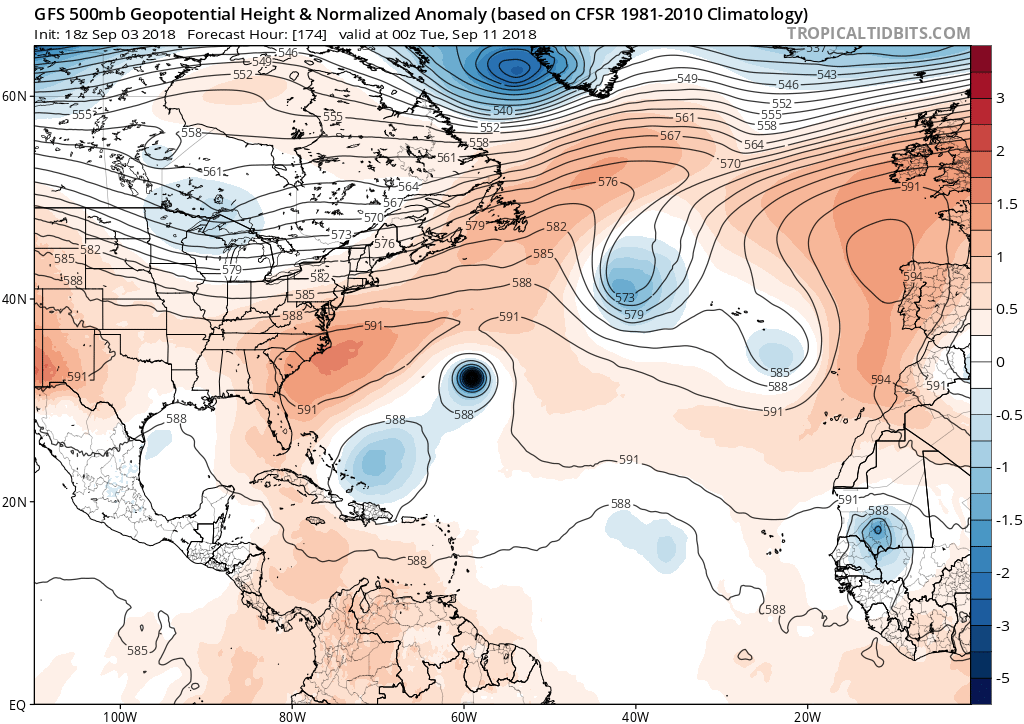
The Uber ridge that the Euro keeps showing simply isn’t there on the GFS.
0 likes
My Weather Station
https://www.wunderground.com/dashboard/pws/KFLPORTS603
https://www.wunderground.com/dashboard/pws/KFLPORTS603
-
Hurricaneman
- Category 5
- Posts: 7404
- Age: 45
- Joined: Tue Aug 31, 2004 3:24 pm
- Location: central florida
Re: ATL: FLORENCE - Models
toad strangler wrote:The Uber ridge that the Euro keeps showing simply isn’t there on the GFS.
Could be the GFS bias and the thing with the GFS is beyond 3 days is when it’s problems/biases show in the runs so beyond 72hrs on the GFS is a crapshoot
0 likes
-
Hypercane_Kyle
- Category 5
- Posts: 3465
- Joined: Sat Mar 07, 2015 7:58 pm
- Location: Cape Canaveral, FL
Re: ATL: FLORENCE - Models
toad strangler wrote:The Uber ridge that the Euro keeps showing simply isn’t there on the GFS.
There's no uber ridge in place by 144 hours. There is a huge opportunity that Florence has to go out to sea, and it entirely depends on how strong it is by that point.
1 likes
My posts are my own personal opinion, defer to the National Hurricane Center (NHC) and other NOAA products for decision making during hurricane season.

Re: ATL: FLORENCE - Models
Hypercane_Kyle wrote:toad strangler wrote:The Uber ridge that the Euro keeps showing simply isn’t there on the GFS.
There's no uber ridge in place by 144 hours. There is a huge opportunity that Florence has to go out to sea, and it entirely depends on how strong it is by that point.
Exactly. Between hours 120 and 150 there is a significant weakness in the ridge on the Euro. Could easily go OTS if Florence is even a cat 1 at that point.
0 likes
Very useful information on the Dvorak Technique --
https://severe.worldweather.wmo.int/TCF ... kBeven.pdf
https://severe.worldweather.wmo.int/TCF ... kBeven.pdf
-
ScottNAtlanta

- Category 5
- Posts: 2535
- Joined: Sat May 25, 2013 3:11 pm
- Location: Atlanta, GA
Re: ATL: FLORENCE - Models
I think I just found something that might affect the track. Typhoon Jebi was forecast to recurve, and now the latest track has it crossing Japan and going NNE into Russia instead of recurving towards Alaska which would have more influence on the strength of the high pressure we've been looking at in the NE US...any thoughts on that?
Seems if the typhoon doesnt recurve, it wont pump the Alaskan ridge, thus less of a central US trof and a weaker ridge over the Atlantic
Seems if the typhoon doesnt recurve, it wont pump the Alaskan ridge, thus less of a central US trof and a weaker ridge over the Atlantic
Last edited by ScottNAtlanta on Mon Sep 03, 2018 5:35 pm, edited 1 time in total.
0 likes
The posts in this forum are NOT official forecast and should not be used as such. They are just the opinion of the poster and may or may not be backed by sound meteorological data. They are NOT endorsed by any professional institution or storm2k.org. For official information, please refer to the NHC and NWS products.
-
toad strangler
- S2K Supporter
- Posts: 4546
- Joined: Sun Jul 28, 2013 3:09 pm
- Location: Earth
- Contact:
Re: ATL: FLORENCE - Models
Hypercane_Kyle wrote:toad strangler wrote:The Uber ridge that the Euro keeps showing simply isn’t there on the GFS.
There's no uber ridge in place by 144 hours. There is a huge opportunity that Florence has to go out to sea, and it entirely depends on how strong it is by that point.
True it’s not in place at 144 but building back in, so what is keeping Florence from slipping away then?
0 likes
My Weather Station
https://www.wunderground.com/dashboard/pws/KFLPORTS603
https://www.wunderground.com/dashboard/pws/KFLPORTS603
-
Hypercane_Kyle
- Category 5
- Posts: 3465
- Joined: Sat Mar 07, 2015 7:58 pm
- Location: Cape Canaveral, FL
Re: ATL: FLORENCE - Models
toad strangler wrote:Hypercane_Kyle wrote:toad strangler wrote:The Uber ridge that the Euro keeps showing simply isn’t there on the GFS.
There's no uber ridge in place by 144 hours. There is a huge opportunity that Florence has to go out to sea, and it entirely depends on how strong it is by that point.
True it’s not in place at 144 but building back in, so what is keeping Florence from slipping away then?
The ridge builds in after that, but by that point Florence has been caught by that weakness and slips away.
0 likes
My posts are my own personal opinion, defer to the National Hurricane Center (NHC) and other NOAA products for decision making during hurricane season.
-
toad strangler
- S2K Supporter
- Posts: 4546
- Joined: Sun Jul 28, 2013 3:09 pm
- Location: Earth
- Contact:
Re: ATL: FLORENCE - Models
Hypercane_Kyle wrote:toad strangler wrote:Hypercane_Kyle wrote:
There's no uber ridge in place by 144 hours. There is a huge opportunity that Florence has to go out to sea, and it entirely depends on how strong it is by that point.
True it’s not in place at 144 but building back in, so what is keeping Florence from slipping away then?
The ridge builds in after that, but by that point Florence has been caught by that weakness and slips away.
Not on the Euro. At least that’s what I’m talking about. The GFS is obvious.
0 likes
My Weather Station
https://www.wunderground.com/dashboard/pws/KFLPORTS603
https://www.wunderground.com/dashboard/pws/KFLPORTS603
-
Hypercane_Kyle
- Category 5
- Posts: 3465
- Joined: Sat Mar 07, 2015 7:58 pm
- Location: Cape Canaveral, FL
Re: ATL: FLORENCE - Models
toad strangler wrote:Hypercane_Kyle wrote:toad strangler wrote:
True it’s not in place at 144 but building back in, so what is keeping Florence from slipping away then?
The ridge builds in after that, but by that point Florence has been caught by that weakness and slips away.
Not on the Euro. At least that’s what I’m talking about. The GFS is obvious.
On the Euro the system is hit by 20-30 knots of shear by day 5 and stays weak enough to miss the weakness.
0 likes
My posts are my own personal opinion, defer to the National Hurricane Center (NHC) and other NOAA products for decision making during hurricane season.
-
Hurricaneman
- Category 5
- Posts: 7404
- Age: 45
- Joined: Tue Aug 31, 2004 3:24 pm
- Location: central florida
Re: ATL: FLORENCE - Models
The 18zGFS operational is on the eastern end of the ensembles, it’s a very delicate steering pattern and if Florence is weaker than the GFS has it it could be westward to the US
0 likes
-
gatorcane

- S2K Supporter
- Posts: 23708
- Age: 48
- Joined: Sun Mar 13, 2005 3:54 pm
- Location: Boca Raton, FL
Re: ATL: FLORENCE - Models
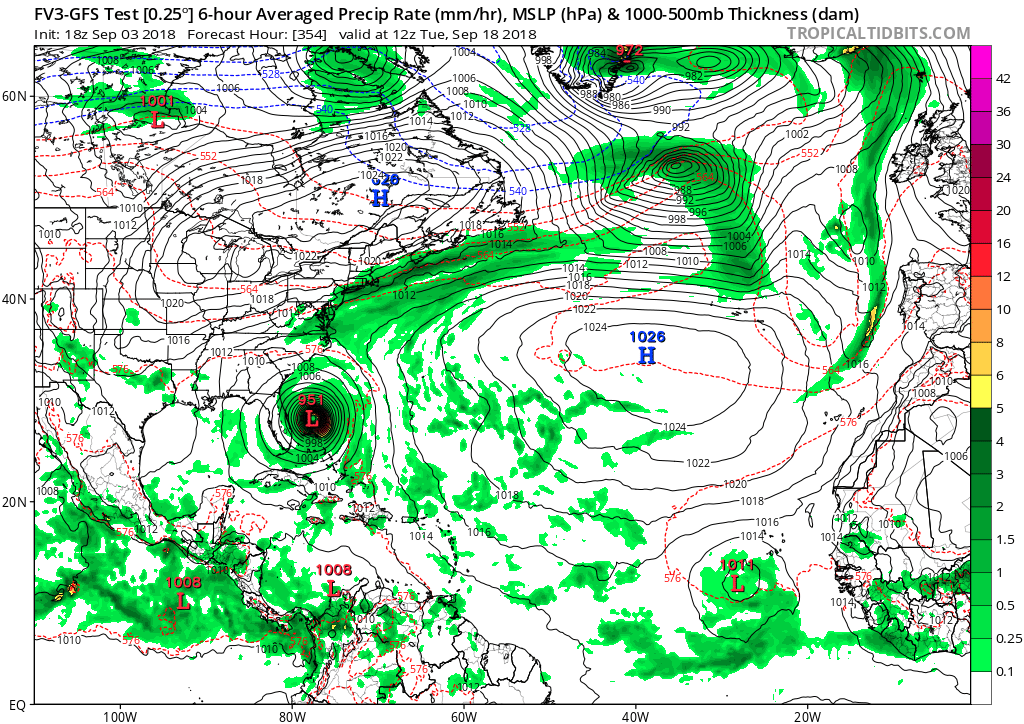
Has anybody seen the 18Z FV3 GFS? This has to be one of the most bizarre runs I have seen. The model has Florence way up at 38N and dives is SW where it ends up in the Bahamas but stops just before hitting Florida. 
Link to full run:
https://www.tropicaltidbits.com/analysi ... 318&fh=186
Link to full run:
https://www.tropicaltidbits.com/analysi ... 318&fh=186
4 likes
-
SEASON_CANCELED

- Category 3

- Posts: 887
- Joined: Mon Jul 06, 2009 5:17 am
- Location: 8 Bit Charlie Sheen
Re: ATL: FLORENCE - Models
Not liking the trend of further west every Time.
Lets throw out that GFS
Lets throw out that GFS
0 likes
i am a big stupid ugly moron with an ugly face and a big butt and my butt stinks and i like to kiss my own butt
Who is online
Users browsing this forum: No registered users and 161 guests