2018 Tropics: Global Model Runs Discussion (Out to day 16)
Moderator: S2k Moderators
Forum rules

The posts in this forum are NOT official forecasts and should not be used as such. They are just the opinion of the poster and may or may not be backed by sound meteorological data. They are NOT endorsed by any professional institution or STORM2K. For official information, please refer to products from the National Hurricane Center and National Weather Service.
-
PSUHiker31
- Tropical Storm

- Posts: 114
- Joined: Tue Oct 03, 2017 2:36 pm
Re: 2018 Tropics: Global Model Runs Discussion (Out to day 16)
The 12Z GFS in particular loves showing weaker storms or no development
0 likes
-
toad strangler

- S2K Supporter

- Posts: 4546
- Joined: Sun Jul 28, 2013 3:09 pm
- Location: Earth
- Contact:
Re: 2018 Tropics: Global Model Runs Discussion (Out to day 16)
Yep,12z GFS completely loses all waves behind Florence.
0 likes
My Weather Station
https://www.wunderground.com/dashboard/pws/KFLPORTS603
https://www.wunderground.com/dashboard/pws/KFLPORTS603
-
gatorcane

- S2K Supporter
- Posts: 23708
- Age: 48
- Joined: Sun Mar 13, 2005 3:54 pm
- Location: Boca Raton, FL
Re: 2018 Tropics: Global Model Runs Discussion (Out to day 16)
Cape Verde train in full effect on today’s Euro 
1 likes
-
toad strangler
- S2K Supporter
- Posts: 4546
- Joined: Sun Jul 28, 2013 3:09 pm
- Location: Earth
- Contact:
Re: 2018 Tropics: Global Model Runs Discussion (Out to day 16)
12z Euro continues to shift W and S with Florence. Look out Carolinas this run.
0 likes
My Weather Station
https://www.wunderground.com/dashboard/pws/KFLPORTS603
https://www.wunderground.com/dashboard/pws/KFLPORTS603
-
cycloneye

- Admin

- Posts: 149338
- Age: 69
- Joined: Thu Oct 10, 2002 10:54 am
- Location: San Juan, Puerto Rico
Re: 2018 Tropics: Global Model Runs Discussion (Out to day 16)
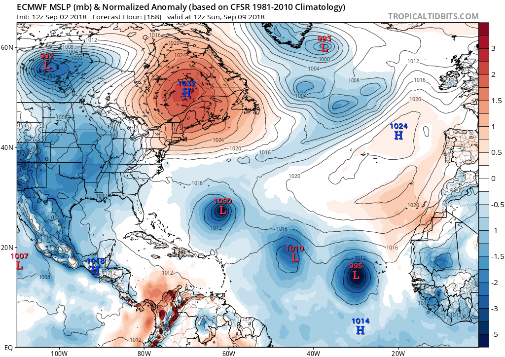
12z Euro much stronger with wave #2 behind Florence. For now the Islands are safe but being September we have to watch all the emerges Africa.

0 likes
Visit the Caribbean-Central America Weather Thread where you can find at first post web cams,radars
and observations from Caribbean basin members Click Here
and observations from Caribbean basin members Click Here

Re: 2018 Tropics: Global Model Runs Discussion (Out to day 16)
toad strangler wrote:12z Euro continues to shift W and S with Florence. Look out Carolinas this run.
My hedge is Florence..... towards Florence
3 likes
Andy D
(For official information, please refer to the NHC and NWS products.)
(For official information, please refer to the NHC and NWS products.)
Re: 2018 Tropics: Global Model Runs Discussion (Out to day 16)
toad strangler wrote:Yep,12z GFS completely loses all waves behind Florence.
Maybe, but not so for the FV3-GFS. Tropics are in full-swing!
https://www.tropicaltidbits.com/analysi ... 212&fh=270
0 likes
Andy D
(For official information, please refer to the NHC and NWS products.)
(For official information, please refer to the NHC and NWS products.)
-
CyclonicFury

- Category 5

- Posts: 2032
- Age: 27
- Joined: Sun Jul 02, 2017 12:32 pm
- Location: NC
- Contact:
Re: 2018 Tropics: Global Model Runs Discussion (Out to day 16)
Models seem to be hinting at some sort of Central American Gyre like system to form in mid-September. GFS and CMC have been showing it.
3 likes
NCSU B.S. in Meteorology Class of 2021. Tropical weather blogger at http://www.cyclonicfury.com. My forecasts and thoughts are NOT official, for official forecasts please consult the National Hurricane Center.
-
toad strangler
- S2K Supporter
- Posts: 4546
- Joined: Sun Jul 28, 2013 3:09 pm
- Location: Earth
- Contact:
Re: 2018 Tropics: Global Model Runs Discussion (Out to day 16)
6z GFS not very bullish post Florence
0 likes
My Weather Station
https://www.wunderground.com/dashboard/pws/KFLPORTS603
https://www.wunderground.com/dashboard/pws/KFLPORTS603
-
Clearcloudz

- Category 2

- Posts: 540
- Joined: Sun Jun 10, 2018 1:46 pm
- Location: Rosenberg TX
Re: 2018 Tropics: Global Model Runs Discussion (Out to day 16)
CyclonicFury wrote:Models seem to be hinting at some sort of Central American Gyre like system to form in mid-September. GFS and CMC have been showing it.
Some of the ECMWF ensemble members are also showing it.
https://weather.us/cyclone-tracks/euro/902-w-263-n/2018090300-240.html
0 likes
-
gatorcane
- S2K Supporter
- Posts: 23708
- Age: 48
- Joined: Sun Mar 13, 2005 3:54 pm
- Location: Boca Raton, FL
Re: 2018 Tropics: Global Model Runs Discussion (Out to day 16)
Check out the FV3 06Z GFS. Has a Cape Verde storm that develops way east moves north then turns west and beelines towards Bahamas. thankfully it is long-range with this setup:
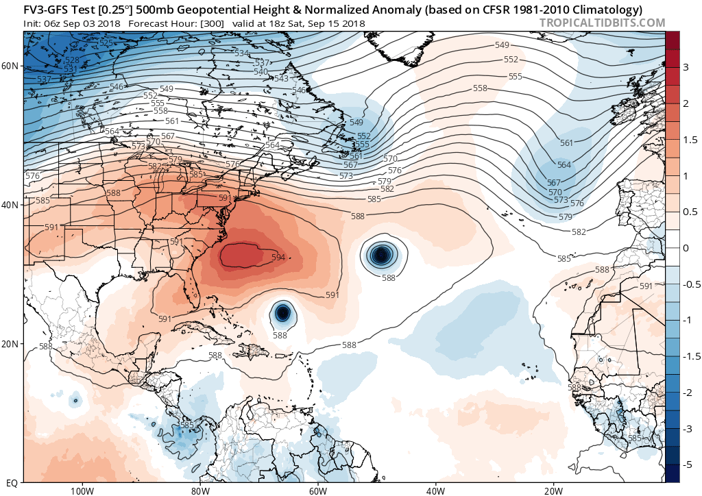
thankfully it is long-range with this setup:
0 likes
-
SootyTern
- S2K Supporter
- Posts: 316
- Age: 57
- Joined: Sun Sep 05, 2004 5:09 pm
- Location: NYC (formerly Homestead, FL)
Re: 2018 Tropics: Global Model Runs Discussion (Out to day 16)
^ well that's not the setup you want to see if you live in South Florida. One of these guys coming across is bound to make us put up our shutters sooner or later
2 likes
Disclaimer:
The posts in this forum are NOT official forecasts and should not be used as such. For official information, please refer to the NHC and NWS products.
Gulf Coast: Opal '95 Georges '98 / So Fla: Katrina '05 Wilma '05 Irma '17
The posts in this forum are NOT official forecasts and should not be used as such. For official information, please refer to the NHC and NWS products.
Gulf Coast: Opal '95 Georges '98 / So Fla: Katrina '05 Wilma '05 Irma '17
-
otowntiger
- Category 5
- Posts: 1932
- Joined: Tue Aug 31, 2004 7:06 pm
Re: 2018 Tropics: Global Model Runs Discussion (Out to day 16)
gatorcane wrote:Check out the FV3 06Z GFS. Has a Cape Verde storm that develops way east moves north then turns west and beelines towards Bahamas.
In that particular set up, it looks like to me, that it could be pushed southwest toward Cuba, right? And is that storm to its NE representing Florence?
0 likes
-
toad strangler
- S2K Supporter
- Posts: 4546
- Joined: Sun Jul 28, 2013 3:09 pm
- Location: Earth
- Contact:
Re: 2018 Tropics: Global Model Runs Discussion (Out to day 16)
otowntiger wrote:gatorcane wrote:Check out the FV3 06Z GFS. Has a Cape Verde storm that develops way east moves north then turns west and beelines towards Bahamas.
In that particular set up, it looks like to me, that it could be pushed southwest toward Cuba, right?
You would think so but the GFS likes to put trap doors in stout ridges lately lol
1 likes
My Weather Station
https://www.wunderground.com/dashboard/pws/KFLPORTS603
https://www.wunderground.com/dashboard/pws/KFLPORTS603
-
CourierPR

- Category 5
- Posts: 1336
- Age: 72
- Joined: Tue Aug 31, 2004 7:53 pm
- Location: Pompano Beach, Florida
Re: 2018 Tropics: Global Model Runs Discussion (Out to day 16)
SootyTern wrote:^ well that's not the setup you want to see if you live in South Florida. One of these guys coming across is bound to make us put up our shutters sooner or later
Met. Joe Bastardi tweeted a few days ago that there would be a pattern similar to what spawned Andrew in '92.
0 likes

Re: 2018 Tropics: Global Model Runs Discussion (Out to day 16)
12z Euro has both the wave that just exited Africa and the one behind it developing.

0 likes
Igor 2010, Sandy 2012, Fay 2014, Gonzalo 2014, Joaquin 2015, Nicole 2016, Humberto 2019, Imelda 2025
I am only a tropical weather enthusiast. My predictions are not official and may or may not be backed by sound meteorological data. For official information, please refer to the NHC and NWS products.
I am only a tropical weather enthusiast. My predictions are not official and may or may not be backed by sound meteorological data. For official information, please refer to the NHC and NWS products.


Re: 2018 Tropics: Global Model Runs Discussion (Out to day 16)
Kazmit wrote:12z Euro has both the wave that just exited Africa and the one behind it developing.
The Crazy GFS has basically nothing after a sharp recurve of Florence.
Tale of 2 extreme models this season.
1 likes


-
AJC3

- Admin
- Posts: 4153
- Age: 62
- Joined: Tue Aug 31, 2004 7:04 pm
- Location: Ballston Spa, New York
- Contact:
Re: 2018 Tropics: Global Model Runs Discussion (Out to day 16)
Just a quick reminder...there are model threads for Florence and 92L, so remember to keep extended range graphics and discussions focused on systems other than those two. Thanks.
1 likes
-
SconnieCane
- Category 5
- Posts: 1013
- Joined: Thu Aug 02, 2018 5:29 pm
- Location: Madison, WI
Re: 2018 Tropics: Global Model Runs Discussion (Out to day 16)
FWIW (not much), 06Z GFS spins up what looks like a Gulf homebrew around hour 200 and brings it into the TX coast in the 990s MB between hours 252 and 264.
0 likes
Who is online
Users browsing this forum: No registered users and 113 guests