
WPAC: MANGKHUT - Post-Tropical
Moderator: S2k Moderators
- 1900hurricane
- Category 5
- Posts: 6059
- Age: 34
- Joined: Fri Feb 06, 2015 12:04 pm
- Location: Houston, TX
- Contact:
WPAC: MANGKHUT - Post-Tropical
New invest barely on the WPac side of the International Date Line.

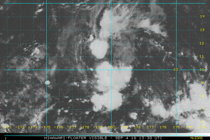
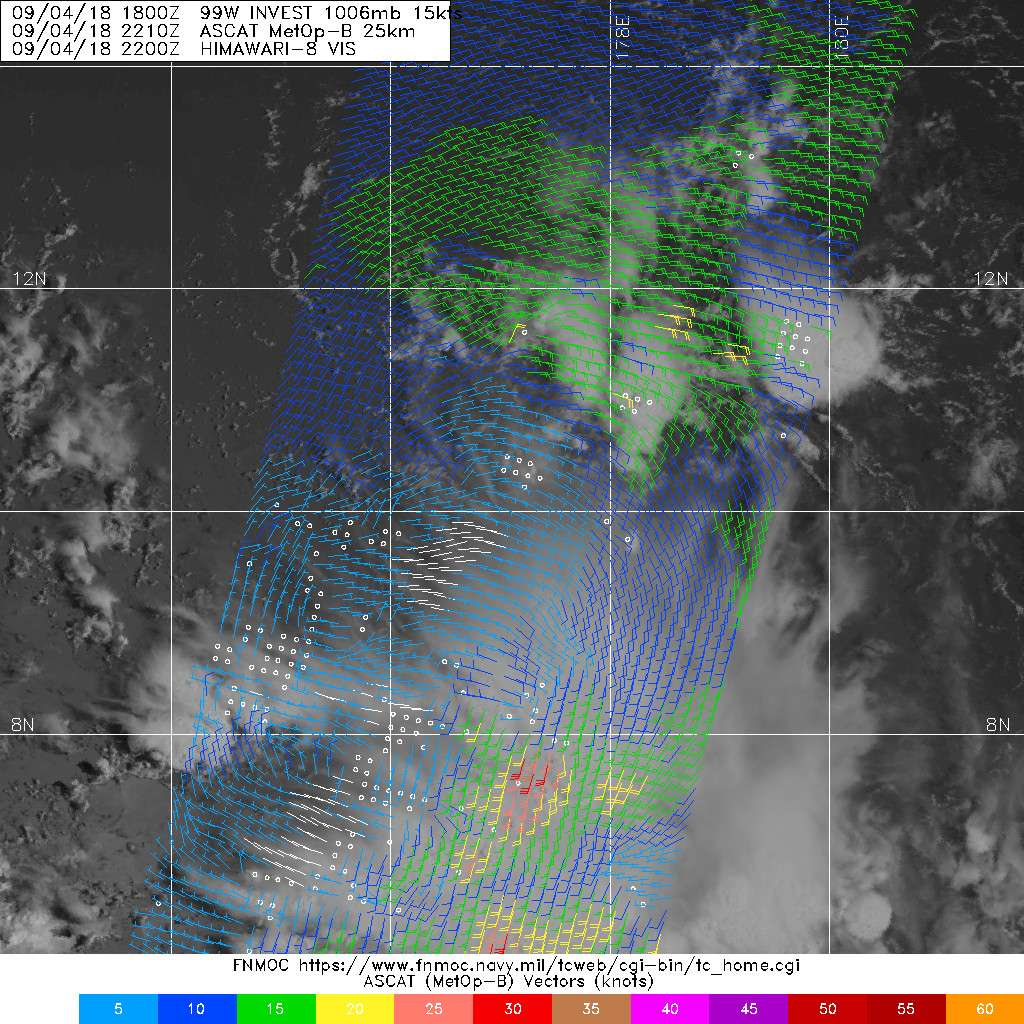
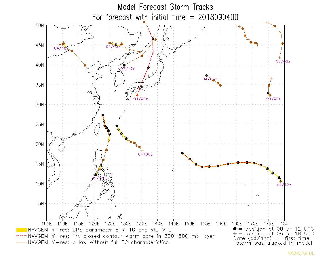
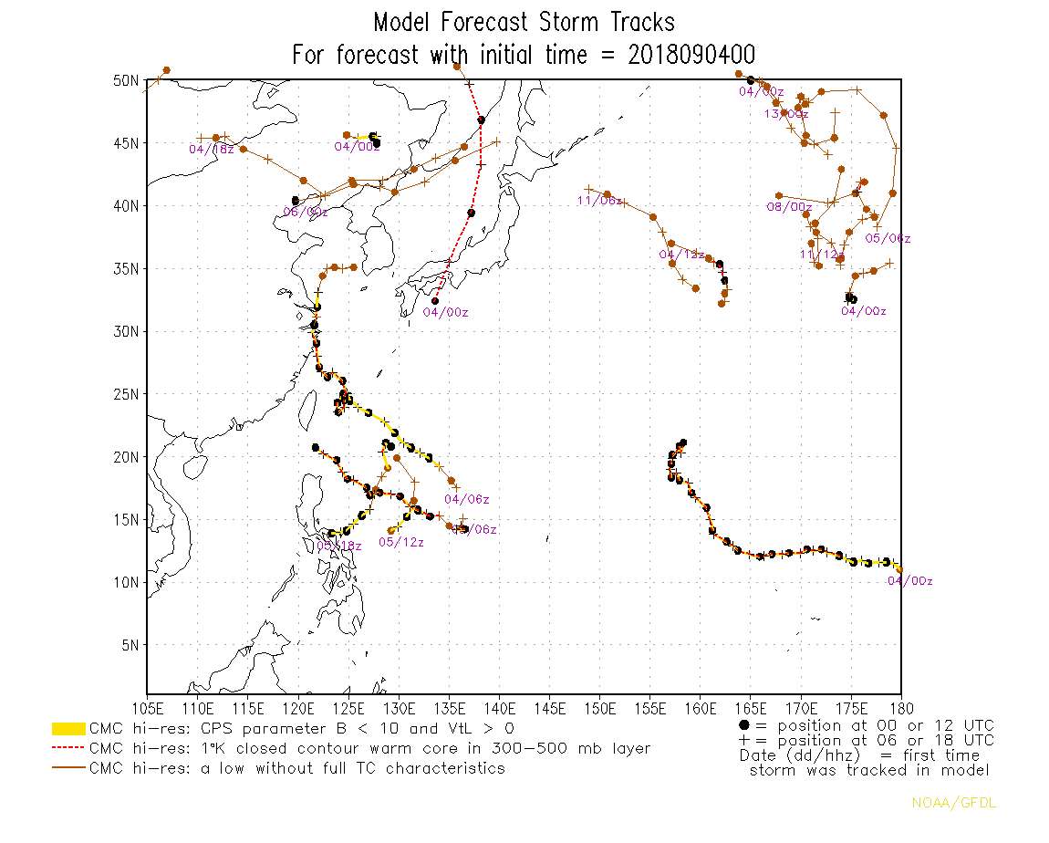
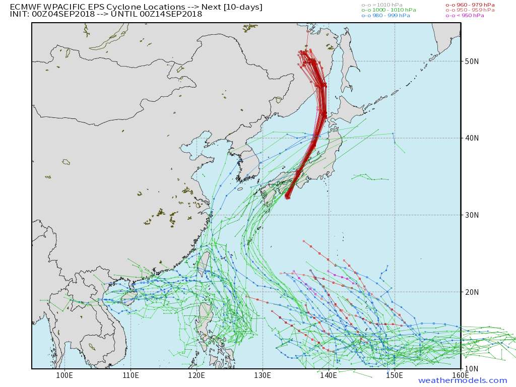
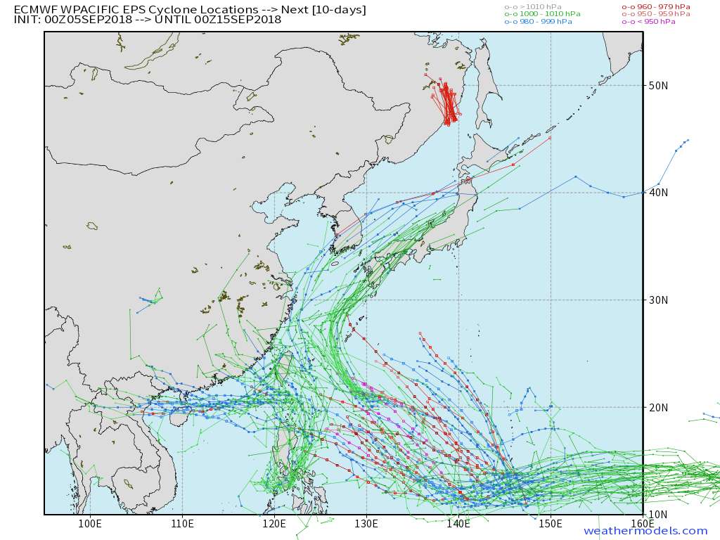
99W INVEST 180904 0000 10.0N 179.5E WPAC 15 1010

Last edited by 1900hurricane on Sun Sep 16, 2018 10:11 pm, edited 6 times in total.
0 likes
Contract Meteorologist. TAMU & MSST. Fiercely authentic, one of a kind. We are all given free will, so choose a life meant to be lived. We are the Masters of our own Stories.
Opinions expressed are mine alone.
Follow me on Twitter at @1900hurricane : Read blogs at https://1900hurricane.wordpress.com/
Opinions expressed are mine alone.
Follow me on Twitter at @1900hurricane : Read blogs at https://1900hurricane.wordpress.com/
- 1900hurricane
- Category 5
- Posts: 6059
- Age: 34
- Joined: Fri Feb 06, 2015 12:04 pm
- Location: Houston, TX
- Contact:
Re: WPAC: Invest 99W
This appears to be the source invest for a system that guidance is developing several days down the road.
0 likes
Contract Meteorologist. TAMU & MSST. Fiercely authentic, one of a kind. We are all given free will, so choose a life meant to be lived. We are the Masters of our own Stories.
Opinions expressed are mine alone.
Follow me on Twitter at @1900hurricane : Read blogs at https://1900hurricane.wordpress.com/
Opinions expressed are mine alone.
Follow me on Twitter at @1900hurricane : Read blogs at https://1900hurricane.wordpress.com/
- mrbagyo
- Category 5
- Posts: 3711
- Age: 32
- Joined: Thu Apr 12, 2012 9:18 am
- Location: 14.13N 120.98E
- Contact:
Re: WPAC: Invest 99W
Yeah, it has strong support from guidance


1 likes
The posts in this forum are NOT official forecast and should not be used as such. They are just the opinion of the poster and may or may not be backed by sound meteorological data. They are NOT endorsed by any professional institution or storm2k.org. For official information, please refer to RSMC, NHC and NWS products.
- mrbagyo
- Category 5
- Posts: 3711
- Age: 32
- Joined: Thu Apr 12, 2012 9:18 am
- Location: 14.13N 120.98E
- Contact:
Re: WPAC: Invest 99W
0 likes
The posts in this forum are NOT official forecast and should not be used as such. They are just the opinion of the poster and may or may not be backed by sound meteorological data. They are NOT endorsed by any professional institution or storm2k.org. For official information, please refer to RSMC, NHC and NWS products.
Re: WPAC: Invest 99W
Most models bring this near the Marianas mid to late next week where exactly and how strong is too premature to speculate at this point.
0 likes
Remember, all of my post aren't official. For official warnings and discussions, Please refer to your local NWS products...
NWS for the Western Pacific
https://www.weather.gov/gum/
NWS for the Western Pacific
https://www.weather.gov/gum/
- mrbagyo
- Category 5
- Posts: 3711
- Age: 32
- Joined: Thu Apr 12, 2012 9:18 am
- Location: 14.13N 120.98E
- Contact:
Re: WPAC: Invest 99W
Long range 00z GFS wants a Jebi 2.0.
SSD storm floater is not upadating ATM

SSD storm floater is not upadating ATM

0 likes
The posts in this forum are NOT official forecast and should not be used as such. They are just the opinion of the poster and may or may not be backed by sound meteorological data. They are NOT endorsed by any professional institution or storm2k.org. For official information, please refer to RSMC, NHC and NWS products.
- mrbagyo
- Category 5
- Posts: 3711
- Age: 32
- Joined: Thu Apr 12, 2012 9:18 am
- Location: 14.13N 120.98E
- Contact:
Re: WPAC: Invest 99W

Latest EPS is hinting some action in the Philippine Sea (area is still largely untapped)
0 likes
The posts in this forum are NOT official forecast and should not be used as such. They are just the opinion of the poster and may or may not be backed by sound meteorological data. They are NOT endorsed by any professional institution or storm2k.org. For official information, please refer to RSMC, NHC and NWS products.
- 1900hurricane
- Category 5
- Posts: 6059
- Age: 34
- Joined: Fri Feb 06, 2015 12:04 pm
- Location: Houston, TX
- Contact:
Re: WPAC: Invest 99W
A marked inverted trough can be seen on the latest ASCAT pass.


0 likes
Contract Meteorologist. TAMU & MSST. Fiercely authentic, one of a kind. We are all given free will, so choose a life meant to be lived. We are the Masters of our own Stories.
Opinions expressed are mine alone.
Follow me on Twitter at @1900hurricane : Read blogs at https://1900hurricane.wordpress.com/
Opinions expressed are mine alone.
Follow me on Twitter at @1900hurricane : Read blogs at https://1900hurricane.wordpress.com/
Re: WPAC: Invest 99W

EURO takes this very close to Guam and deepens it in 940's...


GFS north of Saipan.
0 likes
Remember, all of my post aren't official. For official warnings and discussions, Please refer to your local NWS products...
NWS for the Western Pacific
https://www.weather.gov/gum/
NWS for the Western Pacific
https://www.weather.gov/gum/
Re: WPAC: Invest 99W
0 likes
Remember, all of my post aren't official. For official warnings and discussions, Please refer to your local NWS products...
NWS for the Western Pacific
https://www.weather.gov/gum/
NWS for the Western Pacific
https://www.weather.gov/gum/
Re: WPAC: Invest 99W
UKMET takes a rapidly intensifying system across Guam.
NEW TROPICAL STORM FORECAST TO DEVELOP AFTER 54 HOURS
FORECAST POSITION AT T+ 54 : 12.9N 168.4E
VERIFYING TIME POSITION STRENGTH TENDENCY
-------------- -------- -------- --------
12UTC 07.09.2018 13.2N 166.9E WEAK WEAKENING RAPIDLY
00UTC 08.09.2018 13.9N 163.6E WEAK LITTLE CHANGE
12UTC 08.09.2018 14.2N 159.8E MODERATE LITTLE CHANGE
00UTC 09.09.2018 14.5N 156.1E MODERATE INTENSIFYING SLIGHTLY
12UTC 09.09.2018 13.9N 152.2E STRONG INTENSIFYING SLIGHTLY
00UTC 10.09.2018 13.3N 148.8E STRONG INTENSIFYING SLIGHTLY
12UTC 10.09.2018 13.2N 146.3E INTENSE INTENSIFYING RAPIDLY
00UTC 11.09.2018 13.7N 143.7E INTENSE INTENSIFYING SLIGHTLY
0 likes
Remember, all of my post aren't official. For official warnings and discussions, Please refer to your local NWS products...
NWS for the Western Pacific
https://www.weather.gov/gum/
NWS for the Western Pacific
https://www.weather.gov/gum/
- 1900hurricane
- Category 5
- Posts: 6059
- Age: 34
- Joined: Fri Feb 06, 2015 12:04 pm
- Location: Houston, TX
- Contact:
Re: WPAC: Invest 99W
Now marked as a surface low on the JMA surface analysis.

LOW PRESSURE AREA 1008 HPA NEAR 09N 173E ALMOST STATIONARY.

0 likes
Contract Meteorologist. TAMU & MSST. Fiercely authentic, one of a kind. We are all given free will, so choose a life meant to be lived. We are the Masters of our own Stories.
Opinions expressed are mine alone.
Follow me on Twitter at @1900hurricane : Read blogs at https://1900hurricane.wordpress.com/
Opinions expressed are mine alone.
Follow me on Twitter at @1900hurricane : Read blogs at https://1900hurricane.wordpress.com/
Re: WPAC: Invest 99W
AN AREA OF CONVECTION HAS PERSISTED NEAR 11.2N 174E,
APPROXIMATELY 388 NM EAST-NORTHEAST OF KWAJALEIN. ANIMATED ENHANCED
INFRARED SATELLITE IMAGERY SHOWS A BROAD AND POORLY-ORGANIZED LOW
LEVEL CIRCULATION (LLC) WITH AN AREA OF DEEP CONVECTION SLIGHTLY
DISPLACED TO THE EAST. A 051824Z 91GHZ SSMIS MICROWAVE IMAGE
HIGHLIGHTS THE FRAGMENTED NATURE OF THE FORMATIVE BAND FEEDING INTO
THE LLC. UPPER LEVEL ANALYSIS INDICATES LOW VWS THAT IS EASILY
OFFSET BY VERY GOOD POLEWARD OUTFLOW THAT IS PROVIDING GOOD
VENTILATION TO THE CONVECTION. SEA SURFACE TEMPERATURES FOR THE
REGION ARE FAVORABLE FOR FURTHER DEVELOPMENT (28 - 30 C). MODELS
ARE IN VERY GOOD AGREEMENT THAT THE CIRCULATION WILL MOVE GENERALLY
WESTWARD AND SIGNIFICANTLY DEVELOP OVER THE NEXT FEW DAYS. MAXIMUM
SUSTAINED SURFACE WINDS ARE ESTIMATED AT 15 TO 20 KNOTS. MINIMUM
SEA LEVEL PRESSURE IS ESTIMATED TO BE NEAR 1008 MB. THE POTENTIAL
FOR THE DEVELOPMENT OF A SIGNIFICANT TROPICAL CYCLONE WITHIN THE
NEXT 24 HOURS IS LOW.
0 likes
Remember, all of my post aren't official. For official warnings and discussions, Please refer to your local NWS products...
NWS for the Western Pacific
https://www.weather.gov/gum/
NWS for the Western Pacific
https://www.weather.gov/gum/
- 1900hurricane
- Category 5
- Posts: 6059
- Age: 34
- Joined: Fri Feb 06, 2015 12:04 pm
- Location: Houston, TX
- Contact:
Re: WPAC: Invest 99W
This is still 10+ days out so caveat emptor, but the guidance envelope appears to have 99W eventually heading somewhere from Luzon to the Ryukyus as a significant system.
0 likes
Contract Meteorologist. TAMU & MSST. Fiercely authentic, one of a kind. We are all given free will, so choose a life meant to be lived. We are the Masters of our own Stories.
Opinions expressed are mine alone.
Follow me on Twitter at @1900hurricane : Read blogs at https://1900hurricane.wordpress.com/
Opinions expressed are mine alone.
Follow me on Twitter at @1900hurricane : Read blogs at https://1900hurricane.wordpress.com/
- 1900hurricane
- Category 5
- Posts: 6059
- Age: 34
- Joined: Fri Feb 06, 2015 12:04 pm
- Location: Houston, TX
- Contact:
Re: WPAC: INVEST 99W
Low level vorticity is decently pronounced near 12ishºN, 174ishºE.
0 likes
Contract Meteorologist. TAMU & MSST. Fiercely authentic, one of a kind. We are all given free will, so choose a life meant to be lived. We are the Masters of our own Stories.
Opinions expressed are mine alone.
Follow me on Twitter at @1900hurricane : Read blogs at https://1900hurricane.wordpress.com/
Opinions expressed are mine alone.
Follow me on Twitter at @1900hurricane : Read blogs at https://1900hurricane.wordpress.com/
- mrbagyo
- Category 5
- Posts: 3711
- Age: 32
- Joined: Thu Apr 12, 2012 9:18 am
- Location: 14.13N 120.98E
- Contact:
Re: WPAC: INVEST 99W

0 likes
The posts in this forum are NOT official forecast and should not be used as such. They are just the opinion of the poster and may or may not be backed by sound meteorological data. They are NOT endorsed by any professional institution or storm2k.org. For official information, please refer to RSMC, NHC and NWS products.
- 1900hurricane
- Category 5
- Posts: 6059
- Age: 34
- Joined: Fri Feb 06, 2015 12:04 pm
- Location: Houston, TX
- Contact:
Re: WPAC: INVEST 99W
ASCAT from earlier.


0 likes
Contract Meteorologist. TAMU & MSST. Fiercely authentic, one of a kind. We are all given free will, so choose a life meant to be lived. We are the Masters of our own Stories.
Opinions expressed are mine alone.
Follow me on Twitter at @1900hurricane : Read blogs at https://1900hurricane.wordpress.com/
Opinions expressed are mine alone.
Follow me on Twitter at @1900hurricane : Read blogs at https://1900hurricane.wordpress.com/
Re: WPAC: INVEST 99W
THE AREA OF CONVECTION (INVEST 99W) PREVIOUSLY LOCATED
NEAR 11.2N 174.0E, IS NOW LOCATED NEAR 11.5N 173.5E, APPROXIMATELY
375 NM EAST-NORTHEAST OF KWAJALEIN. ANIMATED ENHANCED INFRARED
SATELLITE IMAGERY SHOWS A BROAD AND POORLY-ORGANIZED LOW LEVEL
CIRCULATION (LLC) WITH AN AREA OF DEEP CONVECTION SLIGHTLY
DISPLACED TO THE EAST. A 051824Z 91GHZ SSMIS MICROWAVE IMAGE
HIGHLIGHTS THE FRAGMENTED NATURE OF THE FORMATIVE BAND FEEDING INTO
THE LLC. UPPER LEVEL ANALYSIS INDICATES LOW VWS THAT IS EASILY
OFFSET BY VERY GOOD POLEWARD OUTFLOW THAT IS PROVIDING GOOD
VENTILATION TO THE CONVECTION. SEA SURFACE TEMPERATURES FOR THE
REGION ARE FAVORABLE FOR FURTHER DEVELOPMENT (28 - 30 C). MODELS
ARE IN VERY GOOD AGREEMENT THAT THE CIRCULATION WILL MOVE GENERALLY
WESTWARD AND SIGNIFICANTLY DEVELOP OVER THE NEXT FEW DAYS. MAXIMUM
SUSTAINED SURFACE WINDS ARE ESTIMATED AT 15 TO 20 KNOTS. MINIMUM
SEA LEVEL PRESSURE IS ESTIMATED TO BE NEAR 1008 MB. THE POTENTIAL
FOR THE DEVELOPMENT OF A SIGNIFICANT TROPICAL CYCLONE WITHIN THE
NEXT 24 HOURS IS LOW.
0 likes
Remember, all of my post aren't official. For official warnings and discussions, Please refer to your local NWS products...
NWS for the Western Pacific
https://www.weather.gov/gum/
NWS for the Western Pacific
https://www.weather.gov/gum/
Re: WPAC: INVEST 99W
This system will be traversing over waters literally untouched. I won't be surprised to see a Cat 5 out of this...


0 likes
Remember, all of my post aren't official. For official warnings and discussions, Please refer to your local NWS products...
NWS for the Western Pacific
https://www.weather.gov/gum/
NWS for the Western Pacific
https://www.weather.gov/gum/
Re: WPAC: INVEST 99W

Gotta love the uncoupled madness that is the GFS.
0 likes
Very useful information on the Dvorak Technique --
https://severe.worldweather.wmo.int/TCF ... kBeven.pdf
Who is online
Users browsing this forum: No registered users and 87 guests