
2018 Tropics: Global Model Runs Discussion (Out to day 16)
Moderator: S2k Moderators
Forum rules

The posts in this forum are NOT official forecasts and should not be used as such. They are just the opinion of the poster and may or may not be backed by sound meteorological data. They are NOT endorsed by any professional institution or STORM2K. For official information, please refer to products from the National Hurricane Center and National Weather Service.
-
wxman22

- Category 5

- Posts: 1913
- Joined: Mon Jan 30, 2006 12:39 am
- Location: Wichita Falls, TX
- Contact:
Re: 2018 Tropics: Global Model Runs Discussion (Out to day 16)
The GFS,CMC, and some of the Euro Ensembles have been spinning up a tropical storm around the Yucatan/Bay of Capache for the last few days,the only difference now, is the last two runs of the GFS is saying that there could be a weakness in the ridge due to a trough in the west, which allows the system to move to the north towards Texas instead of Mexico, just something to watch for now...
1 likes

Re: 2018 Tropics: Global Model Runs Discussion (Out to day 16)
SconnieCane wrote:FWIW (not much), 06Z GFS spins up what looks like a Gulf homebrew around hour 200 and brings it into the TX coast in the 990s MB between hours 252 and 264.
Interesting; I hadn't really taken a look yet but wonder if this was simply a piece of some northern axis "sleeper wave" had largely dragged over Northern South America and into Central America? That, or some spin-off vorticity from a Pacific ITCZ disturbance that somehow was pulled northward?
0 likes
Andy D
(For official information, please refer to the NHC and NWS products.)
(For official information, please refer to the NHC and NWS products.)
-
toad strangler

- S2K Supporter

- Posts: 4546
- Joined: Sun Jul 28, 2013 3:09 pm
- Location: Earth
- Contact:
Re: 2018 Tropics: Global Model Runs Discussion (Out to day 16)
12z GFS has basically killed off the wave behind Florence (92L) BUT has let it slip through this time to the W and into the N Lesser Antilles with minimal vorticity signature.

0 likes
My Weather Station
https://www.wunderground.com/dashboard/pws/KFLPORTS603
https://www.wunderground.com/dashboard/pws/KFLPORTS603

Re: 2018 Tropics: Global Model Runs Discussion (Out to day 16)
toad strangler wrote:12z GFS has basically killed off the wave behind Florence (92L) BUT has let it slip through this time to the W and into the N Lesser Antilles with minimal vorticity signature.
It also buries that home grown Yucatan system into central Mexico at 264 hours.
0 likes
Personal Forecast Disclaimer:
The posts in this forum are NOT official forecast and should not be used as such. They are just the opinion of the poster and may or may not be backed by sound meteorological data. They are NOT endorsed by any professional institution or storm2k.org. For official information, please refer to the NHC and NWS products.
The posts in this forum are NOT official forecast and should not be used as such. They are just the opinion of the poster and may or may not be backed by sound meteorological data. They are NOT endorsed by any professional institution or storm2k.org. For official information, please refer to the NHC and NWS products.
-
mcheer23

- Professional-Met

- Posts: 441
- Age: 32
- Joined: Sun Jun 24, 2012 8:24 pm
- Location: Sugar Land, Texas
Re: 2018 Tropics: Global Model Runs Discussion (Out to day 16)
We need to watch the BOC in about 8 to 10 days.
2 likes
-
HurricaneEric
- Tropical Storm

- Posts: 146
- Age: 31
- Joined: Mon Sep 07, 2015 11:06 am
- Location: Miami, FL
Re: 2018 Tropics: Global Model Runs Discussion (Out to day 16)
12z Euro is getting REAL busy at hour 168 

Sent from my iPhone using Tapatalk
Sent from my iPhone using Tapatalk
0 likes
Irene '99, Katrina '05, Wilma '05, Irma '17 (storms I remember my area getting hurricane force winds/gusts).
The posts in this forum are NOT official forecast and shouldn't be used as such. They are just the opinion of the poster and may or may not be backed by sound meteorological data. For official information, please refer to the experts.
The posts in this forum are NOT official forecast and shouldn't be used as such. They are just the opinion of the poster and may or may not be backed by sound meteorological data. For official information, please refer to the experts.
-
otowntiger
- Category 5
- Posts: 1932
- Joined: Tue Aug 31, 2004 7:06 pm
Re: 2018 Tropics: Global Model Runs Discussion (Out to day 16)
That's quite the tropical fish train! An impressive train, but a re-curving one nonetheless, from the looks of that set up.HurricaneEric wrote:12z Euro is getting REAL busy at hour 168
Sent from my iPhone using Tapatalk
0 likes
-
Hurricaneman

- Category 5
- Posts: 7404
- Age: 45
- Joined: Tue Aug 31, 2004 3:24 pm
- Location: central florida
Re: 2018 Tropics: Global Model Runs Discussion (Out to day 16)
otowntiger wrote:That's quite the tropical fish train! An impressive train, but a re-curving one nonetheless, from the looks of that set up.HurricaneEric wrote:12z Euro is getting REAL busy at hour 168
Sent from my iPhone using Tapatalk
Interesting note by the way and more knowledable folks here please correct me if I'm wrong, but it looks like one of the factors 'saving' the CONUS is an extended (from north to south) ridge of high pressure as opposed to the normal trough that sets up to steer everything out to sea.
Look at 240, I wouldn’t bet on that
0 likes

-
Hurricaneman
- Category 5
- Posts: 7404
- Age: 45
- Joined: Tue Aug 31, 2004 3:24 pm
- Location: central florida
Re: 2018 Tropics: Global Model Runs Discussion (Out to day 16)
SFLcane wrote:Thank you Florence
I wouldn’t say that yet, at 192 92L misses the trough and is in a dangerous position approaching The Bahamas and I would at least watch one of the waves behind 92L also
2 likes
-
Kingarabian

- S2K Supporter
- Posts: 16351
- Joined: Sat Aug 08, 2009 3:06 am
- Location: Honolulu, Hawaii
Re: 2018 Tropics: Global Model Runs Discussion (Out to day 16)
SFLcane wrote:[tweet]https://twitter.com/RyanMaue/status/1037056003739738112[tweet]
I can see at least one more storm forming and becoming named.
0 likes
RIP Kobe Bryant
-
gatorcane

- S2K Supporter
- Posts: 23708
- Age: 48
- Joined: Sun Mar 13, 2005 3:54 pm
- Location: Boca Raton, FL
Re: 2018 Tropics: Global Model Runs Discussion (Out to day 16)
If that many storms do happen per the Euro, you got to think one might slip through. The weakness created by Florence won’t be there the entire time. The ridge over the Eastern US looks very dominant. Usually we see troughs swinging through instead.
Euro heights 192 hours:
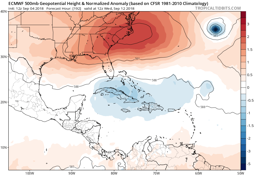
Euro heights 192 hours:
2 likes

Re: 2018 Tropics: Global Model Runs Discussion (Out to day 16)
I think the ole crazy uncle CMC is back and has taken over the Euro. I want my old Euro back.

0 likes
The following post is NOT an official forecast and should not be used as such. It is just the opinion of the poster and may or may not be backed by sound meteorological data. It is NOT endorsed by any professional institution including storm2k.org For Official Information please refer to the NHC and NWS products.
-
toad strangler
- S2K Supporter
- Posts: 4546
- Joined: Sun Jul 28, 2013 3:09 pm
- Location: Earth
- Contact:
Re: 2018 Tropics: Global Model Runs Discussion (Out to day 16)
Looks like a conga line of re curves 
2 likes
My Weather Station
https://www.wunderground.com/dashboard/pws/KFLPORTS603
https://www.wunderground.com/dashboard/pws/KFLPORTS603
Re: 2018 Tropics: Global Model Runs Discussion (Out to day 16)
Hurricaneman wrote:SFLcane wrote:Thank you Florence
I wouldn’t say that yet, at 192 92L misses the trough and is in a dangerous position approaching The Bahamas and I would at least watch one of the waves behind 92L also
Yeah I posted it in the other thread, but it appears to be headed awfully close to the U.S. East Coast, not necessarily following Florence. Of course, it's way out there (time wise), so we have damn near two weeks of watching it.
0 likes
Personal Forecast Disclaimer:
The posts in this forum are NOT official forecast and should not be used as such. They are just the opinion of the poster and may or may not be backed by sound meteorological data. They are NOT endorsed by any professional institution or storm2k.org. For official information, please refer to the NHC and NWS products.
The posts in this forum are NOT official forecast and should not be used as such. They are just the opinion of the poster and may or may not be backed by sound meteorological data. They are NOT endorsed by any professional institution or storm2k.org. For official information, please refer to the NHC and NWS products.
Re: 2018 Tropics: Global Model Runs Discussion (Out to day 16)
gatorcane wrote:If that many storms do happen per the Euro, you got to think one might slip through. The weakness created by Florence won’t be there the entire time. The ridge over the Eastern US looks very dominant. Usually we see troughs swinging through instead.
Euro heights 192 hours:
I agree. I don't remember seeing that strong a ridge so firmly entrenched over the east coast in a long time and every major model is showing this so this is not some Euro fantasy. 60w looks like the point after which anything will get trapped.
1 likes
The following post is NOT an official forecast and should not be used as such. It is just the opinion of the poster and may or may not be backed by sound meteorological data. It is NOT endorsed by any professional institution including storm2k.org For Official Information please refer to the NHC and NWS products.
-
otowntiger
- Category 5
- Posts: 1932
- Joined: Tue Aug 31, 2004 7:06 pm
Re: 2018 Tropics: Global Model Runs Discussion (Out to day 16)
toad strangler wrote:Looks like a conga line of re curves
Lol, yep- I called it ‘tropical fish train’! Sure as someone said, the high could build back in but with that steady succession of systems rolling in I think each system will be keeping the door open for the next guy to go thru.
3 likes

Re: 2018 Tropics: Global Model Runs Discussion (Out to day 16)
otowntiger wrote:toad strangler wrote:Looks like a conga line of re curves
Lol, yep- I called it ‘tropical fish train’! Sure as someone said, the high could build back in but with that steady succession of systems rolling in I think each system will be keeping the door open for the next guy to go thru.
That sounds good to me. Plenty of storms to track, good surf, and no threat to land.
1 likes
Igor 2010, Sandy 2012, Fay 2014, Gonzalo 2014, Joaquin 2015, Nicole 2016, Humberto 2019, Imelda 2025
I am only a tropical weather enthusiast. My predictions are not official and may or may not be backed by sound meteorological data. For official information, please refer to the NHC and NWS products.
I am only a tropical weather enthusiast. My predictions are not official and may or may not be backed by sound meteorological data. For official information, please refer to the NHC and NWS products.
Who is online
Users browsing this forum: No registered users and 68 guests