ATL: FLORENCE - Models

Moderator: S2k Moderators

Message
Author
User avatar
ScottNAtlanta
Category 5
Category 5
Posts: 2367
Joined: Sat May 25, 2013 3:11 pm
Location: Atlanta, GA

Re: ATL: FLORENCE - Models

#501 Postby ScottNAtlanta » Tue Sep 04, 2018 7:02 pm

Hurricaneman wrote:
AutoPenalti wrote:Last few frames...

Image

Yeah, I gave up after that.

Yep after 192hrs the model becomes trash

It looks like Florence spawns... :na:
1 likes   
The posts in this forum are NOT official forecast and should not be used as such. They are just the opinion of the poster and may or may not be backed by sound meteorological data. They are NOT endorsed by any professional institution or storm2k.org. For official information, please refer to the NHC and NWS products.

BYG Jacob

Re: ATL: FLORENCE - Models

#502 Postby BYG Jacob » Tue Sep 04, 2018 7:10 pm

AutoPenalti wrote:GFS says let me plow through this roadblock because why not...
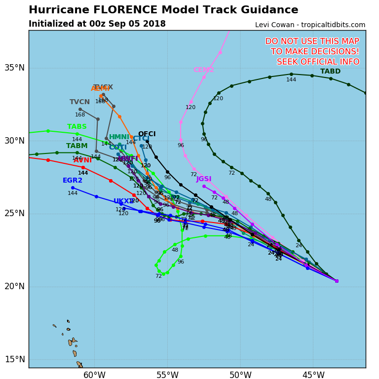
Image

Looks like the "we don't want Irma to bulldoze the SE" runs from last year. Into the trash you go GFS.
0 likes   

User avatar
TheDreamTraveler
Category 2
Category 2
Posts: 641
Joined: Sun Aug 22, 2010 3:10 am
Location: PA

Re: ATL: FLORENCE - Models

#503 Postby TheDreamTraveler » Tue Sep 04, 2018 7:16 pm

WeatherEmperor wrote:
TropicalAnalystwx13 wrote:GFS soundings show east-northeasterlies in the mid levels while Florence is passing south of Bermuda, which would tend to support a southwest motion (think Irma) like the UKMET shows. Not sure why the GFS doesn't indicate it. Probably the same reason the GFS sends the hurricane directly into the ridge.


Can you post an image of the UKMeT and the SW motion it shows?


Sent from my iPhone using Tapatalk


Here you go

Image
1 likes   

Aric Dunn
Category 5
Category 5
Posts: 21238
Age: 42
Joined: Sun Sep 19, 2004 9:58 pm
Location: Ready for the Chase.
Contact:

Re: ATL: FLORENCE - Models

#504 Postby Aric Dunn » Tue Sep 04, 2018 7:24 pm

By the way.. Gordon is likel to play a decent role in Florence's track. the models that do the most recurve wash out Gordon somewhere over Missouri and transition it to a short wave trough that helps keep the weakness in place north of florence longer.
the other models keep gordon circulation fairly intact for a day or so longer and gets absorbed.

so we need to watch that.
2 likes   
Note: If I make a post that is brief. Please refer back to previous posts for the analysis or reasoning. I do not re-write/qoute what my initial post said each time.
If there is nothing before... then just ask :)

Space & Atmospheric Physicist, Embry-Riddle Aeronautical University,
I believe the sky is falling...

plasticup

Re: ATL: FLORENCE - Models

#505 Postby plasticup » Tue Sep 04, 2018 7:25 pm

SouthFLTropics wrote:Wow...the end of that GFS run gave Bermuda the ride of their life. They had stuff swirling all around them.

It would need watches/warnings from two systems simultaneously :lol:
0 likes   

Aric Dunn
Category 5
Category 5
Posts: 21238
Age: 42
Joined: Sun Sep 19, 2004 9:58 pm
Location: Ready for the Chase.
Contact:

Re: ATL: FLORENCE - Models

#506 Postby Aric Dunn » Tue Sep 04, 2018 7:31 pm

plasticup wrote:
SouthFLTropics wrote:Wow...the end of that GFS run gave Bermuda the ride of their life. They had stuff swirling all around them.

It would need watches/warnings from two systems simultaneously :lol:


like the golden girls episode.. lol
2 likes   
Note: If I make a post that is brief. Please refer back to previous posts for the analysis or reasoning. I do not re-write/qoute what my initial post said each time.
If there is nothing before... then just ask :)

Space & Atmospheric Physicist, Embry-Riddle Aeronautical University,
I believe the sky is falling...

User avatar
gatorcane
S2K Supporter
S2K Supporter
Posts: 23691
Age: 47
Joined: Sun Mar 13, 2005 3:54 pm
Location: Boca Raton, FL

Re: ATL: FLORENCE - Models

#507 Postby gatorcane » Tue Sep 04, 2018 8:34 pm

Pretty big left shift in the 00Z guidance just out for Florence. Note NHC track (OFCI) is to the right of these models:

Image
2 likes   

OuterBanker
S2K Supporter
S2K Supporter
Posts: 1731
Joined: Wed Feb 26, 2003 10:53 am
Location: Nags Head, NC
Contact:

Re: ATL: FLORENCE - Models

#508 Postby OuterBanker » Tue Sep 04, 2018 8:36 pm

I tell you it it's impossible to pick a proper allegiance. Yesterday I was hoping that the GFS was right. Today I would choose the Euro. Neither seems to be able to make up it's mind.
3 likes   

LarryWx
S2K Supporter
S2K Supporter
Posts: 6305
Joined: Sun Sep 07, 2003 2:04 pm
Location: GA

Re: ATL: FLORENCE - Models

#509 Postby LarryWx » Tue Sep 04, 2018 8:36 pm

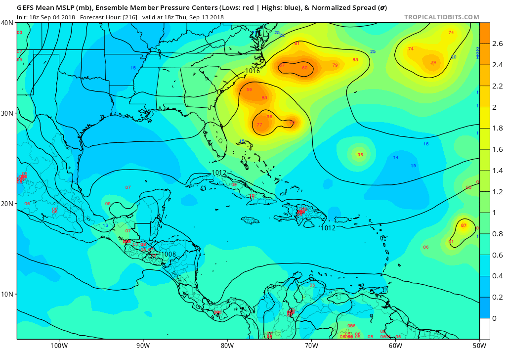
gatorcane wrote:18% GFS ensembles have a significant group targeting SE US coastline:

Image


To add to the above post from gator:

Last 4 GEFS runs with regard to TS+ hits on the US SE coast out of ~21 members:

18Z Mon 0 hits
0Z Tue 0 hits
6Z Tue 4 hits: FL/GA border, SC/NC border, NC OB, skirt NC OB
12Z Tue 2 hits: GA/SC border, SC
———————————————-
New GEFS run (18Z Tue): 5 hits: 2 GA, 3 SC;

4 hit 9/13-4; 1 hit 9/17 after hesitating off NC and then moving SW similar to what some EPS members did. Every member that crossed 30N (~12 members) before reaching 60W recurved safely. 9 members crossed 60W below 30N on Monday. All 5 SE US hitters were from that group of 9 and at 60W were at these latitudes: 29.5, 28.0, 27.5, 26, and 22.5.

So, this is the most threatening GEFS run of at least the last 5. Together with what the very threatening 12Z UKMET suite and the more threatening 12Z EPS vs 0Z EPS showed, odds of not hitting the SE US are obviously not nearly as high as they appeared this morning.
3 likes   
Personal Forecast Disclaimer:
The posts in this forum are NOT official forecasts and should not be used as such. They are just the opinion of the poster and may or may not be backed by sound meteorological data. They are NOT endorsed by any professional institution or storm2k.org. For official information, please refer to the NHC and NWS products.

User avatar
SFLcane
S2K Supporter
S2K Supporter
Posts: 10163
Age: 47
Joined: Sat Jun 05, 2010 1:44 pm
Location: Lake Worth Florida

Re: ATL: FLORENCE - Models

#510 Postby SFLcane » Tue Sep 04, 2018 8:57 pm

The way I see it i still feel it’s rather unlikely Florence threatens the southeast at that latitude without feeling some kinda tug northward as the gfs is portraying infact If it tracks close to the US it will weaken the ridge and allow others to follow out to sea. Let’s hope Florence leads the pack in that direction
0 likes   

Aric Dunn
Category 5
Category 5
Posts: 21238
Age: 42
Joined: Sun Sep 19, 2004 9:58 pm
Location: Ready for the Chase.
Contact:

Re: ATL: FLORENCE - Models

#511 Postby Aric Dunn » Tue Sep 04, 2018 10:11 pm

So this should be looked at.. the NAM has quite a bit more pronounced ridge and also keeps the trough as a single trough not a series of shorwaves. ( of course good for Synoptics) .. look at how early FLorence turns.. slightly lower than UKMET
https://www.tropicaltidbits.com/analysi ... 90500&fh=0
0 likes   
Note: If I make a post that is brief. Please refer back to previous posts for the analysis or reasoning. I do not re-write/qoute what my initial post said each time.
If there is nothing before... then just ask :)

Space & Atmospheric Physicist, Embry-Riddle Aeronautical University,
I believe the sky is falling...

Aric Dunn
Category 5
Category 5
Posts: 21238
Age: 42
Joined: Sun Sep 19, 2004 9:58 pm
Location: Ready for the Chase.
Contact:

Re: ATL: FLORENCE - Models

#512 Postby Aric Dunn » Tue Sep 04, 2018 10:33 pm

ANd the 00z is running.

synoptics are the same only a very small shift in position thus far.
0 likes   
Note: If I make a post that is brief. Please refer back to previous posts for the analysis or reasoning. I do not re-write/qoute what my initial post said each time.
If there is nothing before... then just ask :)

Space & Atmospheric Physicist, Embry-Riddle Aeronautical University,
I believe the sky is falling...

Aric Dunn
Category 5
Category 5
Posts: 21238
Age: 42
Joined: Sun Sep 19, 2004 9:58 pm
Location: Ready for the Chase.
Contact:

Re: ATL: FLORENCE - Models

#513 Postby Aric Dunn » Tue Sep 04, 2018 10:50 pm

GFS 00z. FLorence turn west to wsw at 60h hours.. very similar set up to the NAM synoptic.
0 likes   
Note: If I make a post that is brief. Please refer back to previous posts for the analysis or reasoning. I do not re-write/qoute what my initial post said each time.
If there is nothing before... then just ask :)

Space & Atmospheric Physicist, Embry-Riddle Aeronautical University,
I believe the sky is falling...

User avatar
GeneratorPower
S2K Supporter
S2K Supporter
Posts: 1648
Age: 45
Joined: Sun Dec 18, 2005 11:48 pm
Location: Huntsville, AL

Re: ATL: FLORENCE - Models

#514 Postby GeneratorPower » Tue Sep 04, 2018 10:51 pm

WSW dip at 60 hrs
0 likes   

User avatar
GeneratorPower
S2K Supporter
S2K Supporter
Posts: 1648
Age: 45
Joined: Sun Dec 18, 2005 11:48 pm
Location: Huntsville, AL

Re: ATL: FLORENCE - Models

#515 Postby GeneratorPower » Tue Sep 04, 2018 10:54 pm

Massive ridge all the way to CONUS
0 likes   

Aric Dunn
Category 5
Category 5
Posts: 21238
Age: 42
Joined: Sun Sep 19, 2004 9:58 pm
Location: Ready for the Chase.
Contact:

Re: ATL: FLORENCE - Models

#516 Postby Aric Dunn » Tue Sep 04, 2018 10:54 pm

slightly more ridging at 72hrs and Gordon is a little more defined .. may see a another west shift.
0 likes   
Note: If I make a post that is brief. Please refer back to previous posts for the analysis or reasoning. I do not re-write/qoute what my initial post said each time.
If there is nothing before... then just ask :)

Space & Atmospheric Physicist, Embry-Riddle Aeronautical University,
I believe the sky is falling...

User avatar
Hypercane_Kyle
Category 5
Category 5
Posts: 3352
Joined: Sat Mar 07, 2015 7:58 pm
Location: Cape Canaveral, FL

Re: ATL: FLORENCE - Models

#517 Postby Hypercane_Kyle » Tue Sep 04, 2018 10:54 pm

GFS has nailed Florence's short-term intensity the last few days while being consistent on a recurve scenario; the ECMWF wasn't even close, far too weak.
1 likes   
My posts are my own personal opinion, defer to the National Hurricane Center (NHC) and other NOAA products for decision making during hurricane season.

lando
Tropical Storm
Tropical Storm
Posts: 196
Joined: Wed Aug 31, 2016 11:44 am
Location: Tampa

Re: ATL: FLORENCE - Models

#518 Postby lando » Tue Sep 04, 2018 10:57 pm

Aric Dunn wrote:slightly more ridging at 72hrs and Gordon is a little more defined .. may see a another west shift.


Any graphics?
0 likes   

User avatar
GeneratorPower
S2K Supporter
S2K Supporter
Posts: 1648
Age: 45
Joined: Sun Dec 18, 2005 11:48 pm
Location: Huntsville, AL

Re: ATL: FLORENCE - Models

#519 Postby GeneratorPower » Tue Sep 04, 2018 10:58 pm

0 likes   

Aric Dunn
Category 5
Category 5
Posts: 21238
Age: 42
Joined: Sun Sep 19, 2004 9:58 pm
Location: Ready for the Chase.
Contact:

Re: ATL: FLORENCE - Models

#520 Postby Aric Dunn » Tue Sep 04, 2018 10:58 pm

big difference so far from the 18z is that the 00z has more ridging and the low/trough over the Candian maritime is flatter and farther north at 84 hours by a good deal. with no short waves.
0 likes   
Note: If I make a post that is brief. Please refer back to previous posts for the analysis or reasoning. I do not re-write/qoute what my initial post said each time.
If there is nothing before... then just ask :)

Space & Atmospheric Physicist, Embry-Riddle Aeronautical University,
I believe the sky is falling...


Return to “2018”

Who is online

Users browsing this forum: No registered users and 5 guests