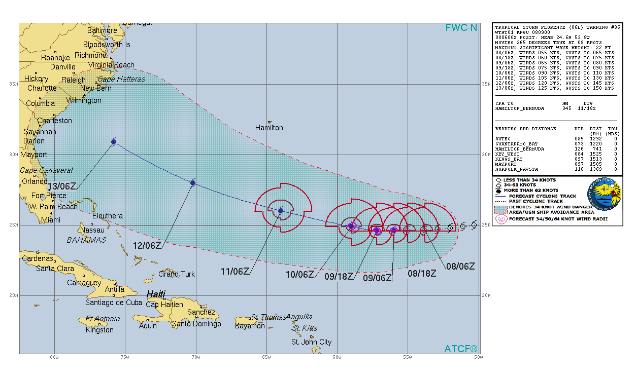
ATL: FLORENCE - Post-Tropical - Discussion

Moderator: S2k Moderators

Message
Author
NC_Cyclone
Tropical Low
Tropical Low
Posts: 30
Joined: Thu Sep 06, 2018 10:28 am

Re: RE: Re: ATL: FLORENCE - Tropical Storm - Discussion

#961 Postby NC_Cyclone » Sat Sep 08, 2018 11:05 am

jlauderdal wrote:
NC_Cyclone wrote:
jlauderdal wrote:Dont overestimate poleward movement, the ridge is very robust now and it could be as strong or stronger next week, nhc acknowledges it as do local nws offices discuss building heights...this system isnt going out to sea regardless of that suspect gfs run


Im not overestimating it. A deeper system will find the weakness that is to the NW of FLorence. The stronger it is the MORE it feels that and the more it goes north. The ONLY ONLY way that this storm makes landfall south of mid-South Carolina is if is stays above 990mb for the next 60+ hrs. Then that gives it time to edge further west, miss the weakness and then get shoved due west.

Right now satellite presentation and microwave imagery suggests it is going to continue to strengthen. It will get tall enough to feel that weakness.
That works if there is a weakness, i see more and more ridging..hopefully that ridge isnt that strong, unlikely


http://tropic.ssec.wisc.edu/real-time/d ... oom=&time=

Its there. noticeable atthe 500-850mb region which FLorence is just now starting to reach into. and then even more noticeable the higher she goes.

If Florence stays weaker... say 995+mb for the next 36-48 hrs then itll likely have a legit shot at reaching further south. If not the north turn will commence.
0 likes   

User avatar
artist
Category 5
Category 5
Posts: 9792
Joined: Mon Jun 06, 2005 3:26 pm
Location: West Palm

Re: ATL: FLORENCE - Tropical Storm - Discussion

#962 Postby artist » Sat Sep 08, 2018 11:06 am

Image
0 likes   

User avatar
FLeastcoast
Tropical Depression
Tropical Depression
Posts: 84
Joined: Sun Sep 03, 2017 2:19 am
Location: NE Florida

Re: RE: Re: ATL: FLORENCE - Tropical Storm - Discussion

#963 Postby FLeastcoast » Sat Sep 08, 2018 11:07 am

lando wrote:
GeneratorPower wrote:
FLeastcoast wrote:
I agree. People should basically prepare right at the beginning of the season for the most part. I have a generator, but have never had to use it. That is a HUGE advantage to being on the same grid as a fire station. Very QUICK to get power restored!


I am an electrical engineer who deals with grid issues and generators every day. I can assure you that being near a fire station means exactly nothing. People love to say they’re on a “hospital grid” or whatever. It’s usually something a real estate agent made up to help sell houses or that some idiot made up as an excuse to not get prepared. You can have a fire station next door and you yourself be without power for weeks.

Human beings have a “normalcy bias”. Look it up, it’s fascinating. Basically it means that humans will lie to themselves in order to feel like they are safe and that everything will stay as it normally is. When I was growing up near Daytona Beach my dad assured me that because we were 15 miles inland, hurricanes would dissipate before they reached our home and thus we didn’t need shutters.

I had a real estate agent show me a commercial building one time. I asked if there were shutters for the large windows, or impact glass. He stopped, pointed to a grove of pine trees nearby and said “see those trees? They act as a natural windbreak. You won’t need shutters here.”

All of that advice is bunk. People need window protection and a generator and also batteries and other supplies in case the generator fails. And training in safe use of a generator.


While I think your correct, I can say I lived two houses down from a high ranking FPL (largest public utility in FL) official and our power was restored faster than most in my neighborhood
The reason of the fire station may not be correct, but I have lived here since 2006, and those of us in the same grid as the fire station get our power restored significantly faster than the rest of the neighborhood. (Including my 2 next door neighbors, who are on a different grid) I agree people tell themselves things to feel safe. Growing up in Broward county, my parents always told us that we were completely safe since we were inland. Ugh

Sent from my SM-G955U using Tapatalk
0 likes   

jaxfladude
Category 5
Category 5
Posts: 1249
Joined: Wed Aug 24, 2005 9:36 pm
Location: Jacksonville, Fla

Re: ATL: FLORENCE - Tropical Storm - Discussion

#964 Postby jaxfladude » Sat Sep 08, 2018 11:07 am

I really hoping that blocking high doesn't steer her to my area when most times these things go northwards. We need a miracle OTS or a manageable coast runner that does as little damage as as possible...sucks to ask for something like that to avoid a much worse outcome. Prayers to all.
0 likes   
Stay safe y'all

jdjaguar
Category 2
Category 2
Posts: 551
Joined: Fri Aug 26, 2005 12:07 pm
Location: Jacksonville Beach, FL

Re: RE: Re: ATL: FLORENCE - Tropical Storm - Discussion

#965 Postby jdjaguar » Sat Sep 08, 2018 11:08 am

jaxfladude wrote:Oh great. Just what we need in jax metro and ne fla/se ga. 3 years in a row a hurricane threatens if Florence comes calling too close for comfort like her siblings Matthew and Irma.. Too early to be sure but heard that in '16/'17 too. Third time's the charm. Welp have to do what have to do.
pgoss11 wrote:This is the first time the NHC in their 11:00 discussion mentions the areas they are most concerned with for Florence direct impact:

2. Interests along the U.S. East Coast, particularly from north
Florida through North Carolina, should closely monitor the progress
of Florence, ensure they have their hurricane plan in place, and
follow any advice given by local officials.


Fired up the generator this morning just to make sure it's functional.

That's my step one.
1 likes   

NC_Cyclone
Tropical Low
Tropical Low
Posts: 30
Joined: Thu Sep 06, 2018 10:28 am

Re: RE: Re: ATL: FLORENCE - Tropical Storm - Discussion

#966 Postby NC_Cyclone » Sat Sep 08, 2018 11:08 am

SSL wrote:
NC_Cyclone wrote:
jlauderdal wrote:Dont overestimate poleward movement, the ridge is very robust now and it could be as strong or stronger next week, nhc acknowledges it as do local nws offices discuss building heights...this system isnt going out to sea regardless of that suspect gfs run


Im not overestimating it. A deeper system will find the weakness that is to the NW of FLorence. The stronger it is the MORE it feels that and the more it goes north. The ONLY ONLY way that this storm makes landfall south of mid-South Carolina is if is stays above 990mb for the next 60+ hrs. Then that gives it time to edge further west, miss the weakness and then get shoved due west.

Right now satellite presentation and microwave imagery suggests it is going to continue to strengthen. It will get tall enough to feel that weakness.


THe 00z EURO doesn't get Florence down to 990mb for another 60+ hours. while the 00z GFS is right on the money at 990mb right now.


There is no weakness mate.


Check this link out...mate... http://tropic.ssec.wisc.edu/real-time/d ... oom=&time=

The higher you go the more of a weakness. Its very obvious. Unless FLorence stays a weak TS for the next 2 days or more its going to find that weakness
1 likes   

HurricaneEric
Tropical Storm
Tropical Storm
Posts: 146
Age: 30
Joined: Mon Sep 07, 2015 11:06 am
Location: Miami, FL

Re: ATL: FLORENCE - Tropical Storm - Discussion

#967 Postby HurricaneEric » Sat Sep 08, 2018 11:09 am

artist wrote:Image


Don’t want to be an alarmist or sensationalist here but that’s a bit unsettling considering a few small SW shifts can actually put my area (SFL) on the extreme left side of the cone. :eek:
0 likes   
Irene '99, Katrina '05, Wilma '05, Irma '17 (storms I remember my area getting hurricane force winds/gusts).

The posts in this forum are NOT official forecast and shouldn't be used as such. They are just the opinion of the poster and may or may not be backed by sound meteorological data. For official information, please refer to the experts.

drewschmaltz
S2K Supporter
S2K Supporter
Posts: 350
Joined: Thu Aug 27, 2015 8:19 pm

Re: ATL: FLORENCE - Tropical Storm - Discussion

#968 Postby drewschmaltz » Sat Sep 08, 2018 11:10 am

Thats a great link! compare the 700-850MB to the 500-850mb layer. Notice the 700mb layer the storm HAS to move to the south. But at the 500-850mb layer there are two circulations and a weakness in between. A strong storm will find this weakness QUICKER than a weaker storm which would have to go ALLL the way around the 700-850mb layer.

So thats the key. If FLorence keeps deepening then he will shoot up into that weakness quicker and quicker.


Like so?

Image

I might not have that exactly right, also of note would be this. Look at the difference between the last 3 hours on the 700mb. Definitely looks like the area of immediate weakness is WSW of her. 3 hours ago it was WNW. Am I seeing this correctly???

http://tropic.ssec.wisc.edu/real-time/dlmmain.php?&basin=atlantic&sat=wg8&prod=dlm1&zoom=&time=-1
VS
http://tropic.ssec.wisc.edu/real-time/dlmmain.php?&basin=atlantic&sat=wg8&prod=dlm1&zoom=&time=
Last edited by drewschmaltz on Sat Sep 08, 2018 11:19 am, edited 2 times in total.
0 likes   
I HAVE ABSOLUTELY NO IDEA WHAT I'M TALKING ABOUT. PLEASE CONSULT SOMEONE WHO DOES. START WITH THE NHC. ALL POSTS ARE FOR ENTERTAINMENT PURPOSES ONLY.

User avatar
chaser1
S2K Supporter
S2K Supporter
Posts: 5472
Age: 64
Joined: Sat Oct 15, 2005 5:59 pm
Location: Longwood, Fl

Re: ATL: FLORENCE - Tropical Storm - Discussion

#969 Postby chaser1 » Sat Sep 08, 2018 11:10 am

NC_Cyclone wrote:For those keeping track, a Florence that starts strengthening now gives much credit to a northern track solution.

ALL southern tracks keep Florence from strengthening for the next 2-3 days still.


All other variables being equal I'd say there's validity to that. Really does apply the most at those track points where ridging is anticipated to be at it weakest (now perhaps?) I suppose we should look out for and anticipate some slight increase in latitude during later today/tonight. The increase in intensity anticipated starting around 24 hrs. however, was already baked into the 2-3 day range track forecast. At that point high end intensity itself will play far less a role in track outcome, compared to exactly where, how strong, and how oriented the anticipated strong ridge that is expected to develop in the 3-5 day range as discussed in detail in both of today's NHC cyclone discussions. Should these pronounced mid and upper level height rises occur even slightly closer to or extend further west of Bermuda, then the North/Central Florida coastline could have a "big red X" on it. Conversely, if this strong ridge parks itself a bit further north or were a bit late (12-24 hrs.?) in arriving to the party, then Florence will by then possibly have gained enough latitude to have South or North Carolina in her sights prior to hitting that wall and possibly turning more sharply back to the west toward landfall. It sounds to me increasing inevitable that a brutally strong blocking ridge will at some point impact a more westward adjusted motion (and probably at an increased forward speed) toward the latter part of the forecast period. Therefore my guess at what will be largely telling regarding where eventual landfall may occur, is the extent of latitude that Florence will gain during the near term (now through 60 hours). If the present east to west low level (weaker heights/less depth) ridge results in a nearer term WNW (or N.W.) motion then I'd have to think somewhere in the Carolina's will be ground zero. On the other hand, if we continue to see Florence somehow continue westward in response to the low level ridge in place AND begin to track south of NHC 12 hr. - 48 hr. track forecast points, plan on seeing NHC making some fairly abrupt southward track shifts by Sunday night. Right now, my guess is Savannah.
2 likes   
Andy D

(For official information, please refer to the NHC and NWS products.)

BobHarlem
Category 5
Category 5
Posts: 2110
Joined: Thu Oct 20, 2005 6:11 pm

Re: ATL: FLORENCE - Tropical Storm - Discussion

#970 Postby BobHarlem » Sat Sep 08, 2018 11:13 am

@Weathernerds

Based on the recent ASCAT pass it seems #Florence is starting to move southwestward. Some of this is just the mid-level center realigning with the low-level center, but it sure looks to be losing latitude.
#wxtwitter
 https://twitter.com/Weathernerds/status/1038087605177524226


1 likes   

User avatar
artist
Category 5
Category 5
Posts: 9792
Joined: Mon Jun 06, 2005 3:26 pm
Location: West Palm

Re: ATL: FLORENCE - Tropical Storm - Discussion

#971 Postby artist » Sat Sep 08, 2018 11:14 am

HurricaneEric wrote:
artist wrote:Image


Don’t want to be an alarmist or sensationalist here but that’s a bit unsettling considering a few small SW shifts can actually put my area (SFL) on the extreme left side of the cone. :eek:

Until we see the turn we need to be prepared. At this point in time, if everything comes together as the NHC predicts, we should be ok. My motto is always to be prepared for the just in case this far out.
3 likes   

User avatar
cycloneye
Admin
Admin
Posts: 145360
Age: 68
Joined: Thu Oct 10, 2002 10:54 am
Location: San Juan, Puerto Rico

Re: ATL: FLORENCE - Recon Discussion

#972 Postby cycloneye » Sat Sep 08, 2018 11:15 am

Going to make a second pass.
0 likes   
Visit the Caribbean-Central America Weather Thread where you can find at first post web cams,radars
and observations from Caribbean basin members Click Here

NC_Cyclone
Tropical Low
Tropical Low
Posts: 30
Joined: Thu Sep 06, 2018 10:28 am

Re: ATL: FLORENCE - Tropical Storm - Discussion

#973 Postby NC_Cyclone » Sat Sep 08, 2018 11:16 am

chaser1 wrote:
NC_Cyclone wrote:For those keeping track, a Florence that starts strengthening now gives much credit to a northern track solution.

ALL southern tracks keep Florence from strengthening for the next 2-3 days still.


All other variables being equal I'd say there's validity to that. Really does apply the most at those track points where ridging is anticipated to be at it weakest (now perhaps?) I suppose we should look out for and anticipate some slight increase in latitude during later today/tonight. The increase in intensity anticipated starting around 24 hrs. however, was already baked into the 2-3 day range track forecast. At that point high end intensity itself will play far less a role in track outcome, compared to exactly where, how strong, and how oriented the anticipated strong ridge that is expected to develop in the 3-5 day range as discussed in detail in both of today's NHC cyclone discussions. Should these pronounced mid and upper level height rises occur even slightly closer to or extend further west of Bermuda, then the North/Central Florida coastline could have a "big red X" on it. Conversely, if this strong ridge parks itself a bit further north or were a bit late (12-24 hrs.?) in arriving to the party, then Florence will by then possibly have gained enough latitude to have South or North Carolina in her sights prior to hitting that wall and possibly turning more sharply back to the west toward landfall. It sounds to me increasing inevitable that a brutally strong blocking ridge will at some point impact a more westward adjusted motion (and probably at an increased forward speed) toward the latter part of the forecast period. Therefore my guess at what will be largely telling regarding where eventual landfall may occur, is the extent of latitude that Florence will gain during the near term (now through 60 hours). If the present east to west low level (weaker heights/less depth) ridge results in a nearer term WNW (or N.W.) motion then I'd have to think somewhere in the Carolina's will be ground zero. On the other hand, if we continue to see Florence somehow continue westward in response to the low level ridge in place AND begin to track south of NHC 12 hr. - 48 hr. track forecast points, plan on seeing NHC making some fairly abrupt southward track shifts by Sunday night. Right now, my guess is Savannah.


Agreed. It seems the next 48-72 hours will be key in determining a landfall location. Essentially the question is where will Florence eject from its current position? Also its hard to determine ridging too between models due to the nuance of a very powerful hurricane. Lots to watch for.

For now I'd keep my eyes on Florence's strength over the next day. If we see some solid strengthening this evening the chance of it ejecting out on a northerly track will be higher. If we go to bed Sunday and Florence is still like it is now then your track may just be dead on.
0 likes   

User avatar
chaser1
S2K Supporter
S2K Supporter
Posts: 5472
Age: 64
Joined: Sat Oct 15, 2005 5:59 pm
Location: Longwood, Fl

Re: ATL: FLORENCE - Tropical Storm - Discussion

#974 Postby chaser1 » Sat Sep 08, 2018 11:30 am

BobHarlem wrote:@Weathernerds

Based on the recent ASCAT pass it seems #Florence is starting to move southwestward. Some of this is just the mid-level center realigning with the low-level center, but it sure looks to be losing latitude.
#wxtwitter
 https://twitter.com/Weathernerds/status/1038087605177524226


Looking at close up visible loop length vs. ASCAT data as shown my sense on motion - right now, is generally west V E R Y slowly. At present rate of speed, i'd pay less attention to apperant motion and attribute what we see to internal dynamic changes taking place. Watch the 12, 24, 36, & 48 hr. forecast points. The proof will be in the Atlantic pudding lol.
1 likes   
Andy D

(For official information, please refer to the NHC and NWS products.)

User avatar
cycloneye
Admin
Admin
Posts: 145360
Age: 68
Joined: Thu Oct 10, 2002 10:54 am
Location: San Juan, Puerto Rico

Re: ATL: FLORENCE - Recon Discussion

#975 Postby cycloneye » Sat Sep 08, 2018 11:31 am

Around 990 mbs and winds to to 65 kts in pass.
0 likes   
Visit the Caribbean-Central America Weather Thread where you can find at first post web cams,radars
and observations from Caribbean basin members Click Here

User avatar
ScottNAtlanta
Category 5
Category 5
Posts: 2367
Joined: Sat May 25, 2013 3:11 pm
Location: Atlanta, GA

Re: ATL: FLORENCE - Tropical Storm - Discussion

#976 Postby ScottNAtlanta » Sat Sep 08, 2018 11:34 am

Image

Starting to get its act together...look at all the lightning in the inner banding
6 likes   
The posts in this forum are NOT official forecast and should not be used as such. They are just the opinion of the poster and may or may not be backed by sound meteorological data. They are NOT endorsed by any professional institution or storm2k.org. For official information, please refer to the NHC and NWS products.

NC_Cyclone
Tropical Low
Tropical Low
Posts: 30
Joined: Thu Sep 06, 2018 10:28 am

Re: ATL: FLORENCE - Tropical Storm - Discussion

#977 Postby NC_Cyclone » Sat Sep 08, 2018 11:34 am

With Florence reorganizing it will be bouncing all over the place. don't get caught up in a bump NW or SW or whatever. On a day like today with a storm barely moving we have to wait for the longer term motion.
4 likes   

User avatar
GCANE
S2K Supporter
S2K Supporter
Posts: 11497
Joined: Mon Oct 22, 2007 8:03 am

ATL: FLORENCE - Tropical Storm - Discussion

#978 Postby GCANE » Sat Sep 08, 2018 11:38 am

2nd pass thru the core for Kermit.
High rain rate.
Should get a Vort message shortly with an idea about the track.

Image
2 likes   

User avatar
eastcoastFL
Category 5
Category 5
Posts: 3901
Age: 43
Joined: Thu Apr 12, 2007 12:29 pm
Location: Palm City, FL

Re: ATL: FLORENCE - Tropical Storm - Discussion

#979 Postby eastcoastFL » Sat Sep 08, 2018 11:40 am

Just went to BJs in Jensen Beach to stock up and they have a ton of water and batteries up front so they are preparing just incase. Im stocked up now so if any of these storms show up I don't have to do the dance with all the crazies.

Be prepared folks.
4 likes   
Personal Forecast Disclaimer:
The posts in this forum are NOT official forecast and should not be used as such. They are just the opinion of the poster and may or may not be backed by sound meteorological data. They are NOT endorsed by any professional institution or storm2k.org. For official information, please refer to the NHC and NWS products.

NC_Cyclone
Tropical Low
Tropical Low
Posts: 30
Joined: Thu Sep 06, 2018 10:28 am

Re: ATL: FLORENCE - Tropical Storm - Discussion

#980 Postby NC_Cyclone » Sat Sep 08, 2018 11:40 am

2nd center fix is a bit NW of first.
0 likes   


Return to “2018”

Who is online

Users browsing this forum: No registered users and 1 guest