ATL: FLORENCE - Models
Moderator: S2k Moderators
-
drewschmaltz
- S2K Supporter

- Posts: 351
- Joined: Thu Aug 27, 2015 8:19 pm
Re: ATL: FLORENCE - Models
Is there a way to get estimated rainfall totals from this run?
0 likes
I HAVE ABSOLUTELY NO IDEA WHAT I'M TALKING ABOUT. PLEASE CONSULT SOMEONE WHO DOES. START WITH THE NHC. ALL POSTS ARE FOR ENTERTAINMENT PURPOSES ONLY.
-
tarheelprogrammer

- S2K Supporter
- Posts: 1793
- Joined: Mon Mar 28, 2016 9:25 pm
- Location: Raleigh, NC area (Garner, NC)
Re: ATL: FLORENCE - Models
Sadly, I think this is the GFS's attempt to come to the same conclusion as the other models, which is the ridge will be slightly stronger and will force it to move west some. You can see it has a lot more of a western component to it overall on this run. Even the loop itself is further west, I think consensus is building for northeast SC to the Outer Banks as a hit. Here is to hoping the 0z trends completely off shore again 
0 likes
My posts are not official forecasts. They are just my opinion and may or may not be backed by sound meteorological data. They are NOT endorsed by any professional institution or storm2k.org. For official information, please refer to the NHC and NWS products.

Re: ATL: FLORENCE - Models
Aric Dunn wrote:Steve wrote:Aric Dunn wrote:
which = poppycock.
It’s the GFS. You can’t totally discount a stall/loop as other models have shown similar. Looks to nudge sw. But what it’s showing is a strengthening ridge overtop and stronger than 12z.
you absolutely can.. because it is the GFS lol
Haha. Yeah I know. But this is the opposite of what it usually does with breaking down those ridges.
—————————
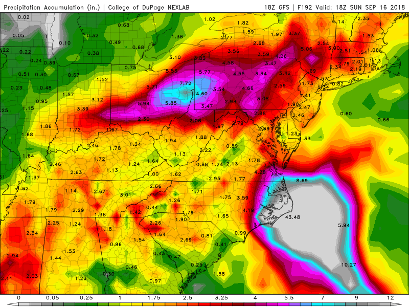
Speaking of the GFS, 25” rains are mostly offshore and toward Buxton, Cape Hatteras and Ocracoke Island.
https://www.tropicaltidbits.com/analysi ... 818&fh=186
0 likes
-
supercane4867
- Category 5

- Posts: 4966
- Joined: Wed Nov 14, 2012 10:43 am
Re: ATL: FLORENCE - Models
drewschmaltz wrote:Is there a way to get estimated rainfall totals from this run?
I guess you need a bigger color scale for it

0 likes
-
tolakram
- Admin

- Posts: 20186
- Age: 62
- Joined: Sun Aug 27, 2006 8:23 pm
- Location: Florence, KY (name is Mark)
Re: ATL: FLORENCE - Models
The run is fun (I guess you can call it fun) but in my opinion it seems to be getting very clear that NC/ SC have to take this very seriously. We'll see some refinement in the 0Z runs and more as more and more data gets input but we're already past the point where both models corrected the Irma track last year into Florida. Regardless weather it heads straight in or meanders off shore both models show the meandering which is going to result in a ton of rain and lots of flooding. I do hope everyone is prepared. So what if it misses, the prep is WORTH IT.
1 likes
M a r k
- - - - -
Join us in chat: Storm2K Chatroom Invite. Android and IOS apps also available.
The posts in this forum are NOT official forecasts and should not be used as such. Posts are NOT endorsed by any professional institution or STORM2K.org. For official information and forecasts, please refer to NHC and NWS products.
-
drewschmaltz
- S2K Supporter
- Posts: 351
- Joined: Thu Aug 27, 2015 8:19 pm
Re: ATL: FLORENCE - Models
Steve wrote:Speaking of the GFS, 25” rains are mostly offshore and toward Buxton, Cape Hatteras and Ocracoke Island.
https://www.tropicaltidbits.com/analysi ... 818&fh=186
Floyd was 15" Wilmington I think maxed out total rainfall for the storm at 19". By the time this run is over, the entire eastern half of NC is well over 25".
Last edited by drewschmaltz on Sat Sep 08, 2018 5:37 pm, edited 1 time in total.
1 likes
I HAVE ABSOLUTELY NO IDEA WHAT I'M TALKING ABOUT. PLEASE CONSULT SOMEONE WHO DOES. START WITH THE NHC. ALL POSTS ARE FOR ENTERTAINMENT PURPOSES ONLY.
-
supercane4867
- Category 5
- Posts: 4966
- Joined: Wed Nov 14, 2012 10:43 am
Re: ATL: FLORENCE - Models
If this does pan out, the real numbers probably will be Harvey like
0 likes
-
HurricaneBelle

- S2K Supporter
- Posts: 1209
- Joined: Sun Aug 27, 2006 6:12 pm
- Location: Clearwater, FL
Re: ATL: FLORENCE - Models
supercane4867 wrote:drewschmaltz wrote:Is there a way to get estimated rainfall totals from this run?
I guess you need a bigger color scale for it
"they've gone plaid"
Last edited by HurricaneBelle on Sat Sep 08, 2018 5:38 pm, edited 1 time in total.
3 likes
-
CalmBeforeStorm

- Category 2

- Posts: 600
- Age: 72
- Joined: Tue Aug 10, 2004 7:55 pm
- Location: Stuart, Florida
Re: ATL: FLORENCE - Models
At 210 hrs Flo is still on the N.C. coast in this run and has been for over 3 days.
1 likes
-
drewschmaltz
- S2K Supporter
- Posts: 351
- Joined: Thu Aug 27, 2015 8:19 pm
Re: ATL: FLORENCE - Models
supercane4867 wrote:If this does pan out, the real numbers probably will be Harvey like
No one wanted to believe that Harvey run was real... Will you post the image again when Florence finally leaves NC? She's still there at hour 216.
0 likes
I HAVE ABSOLUTELY NO IDEA WHAT I'M TALKING ABOUT. PLEASE CONSULT SOMEONE WHO DOES. START WITH THE NHC. ALL POSTS ARE FOR ENTERTAINMENT PURPOSES ONLY.
Re: ATL: FLORENCE - Models
CalmBeforeStorm wrote:At 210 hrs Flo is still on the N.C. coast in this run and has been for over 3 days.
Yeah. 3+. A deeper shortwave is across Minnesota early Monday and a trough split farther east in the Atlanti has brought a piece of energy close to Florence. We will see if there is an out or more movement with these things showing up.
https://www.tropicaltidbits.com/analysi ... 818&fh=204
1 likes
-
tarheelprogrammer
- S2K Supporter
- Posts: 1793
- Joined: Mon Mar 28, 2016 9:25 pm
- Location: Raleigh, NC area (Garner, NC)
Re: ATL: FLORENCE - Models
I wonder if the ensemble members for the GFS come further west as well?????????????? 
0 likes
My posts are not official forecasts. They are just my opinion and may or may not be backed by sound meteorological data. They are NOT endorsed by any professional institution or storm2k.org. For official information, please refer to the NHC and NWS products.
-
RevDodd

- Tropical Storm

- Posts: 184
- Joined: Wed Aug 11, 2004 10:40 am
- Location: Fayetteville, NC
- Contact:
Re: ATL: FLORENCE - Models
drewschmaltz wrote:Seems pretty reasonable. High five GFS.

Someone on the OBX must have run over the GFS's dog to earn that sort of punishment!
1 likes
-
Aric Dunn
- Category 5
- Posts: 21238
- Age: 43
- Joined: Sun Sep 19, 2004 9:58 pm
- Location: Ready for the Chase.
- Contact:
Re: ATL: FLORENCE - Models
tarheelprogrammer wrote:I wonder if the ensemble members for the GFS come further west as well??????????????
very likely.
1 likes
Note: If I make a post that is brief. Please refer back to previous posts for the analysis or reasoning. I do not re-write/qoute what my initial post said each time.
If there is nothing before... then just ask
Space & Atmospheric Physicist, Embry-Riddle Aeronautical University,
I believe the sky is falling...
If there is nothing before... then just ask
Space & Atmospheric Physicist, Embry-Riddle Aeronautical University,
I believe the sky is falling...
-
galaxy401

- Category 5
- Posts: 2446
- Age: 30
- Joined: Sat Aug 25, 2012 9:04 pm
- Location: Casa Grande, Arizona
Re: ATL: FLORENCE - Models
Yeah....yeah....that run wasn't good.....That better be a busted run...but the trend is not looking good......
0 likes
Got my eyes on moving right into Hurricane Alley: Florida.
-
hurricaneCW
- Category 5
- Posts: 1799
- Joined: Wed Mar 03, 2010 6:20 am
- Location: Toms River, NJ
Re: ATL: FLORENCE - Models
You better prepare if you live in the Carolinas, the gfs is spitting out Harvey level rainfall totals.
Gfs is now very close to what the other globals are showing, it's just a bit further east. Very good 5 day consensus actually.
Gfs is now very close to what the other globals are showing, it's just a bit further east. Very good 5 day consensus actually.
0 likes
-
meriland29

- Category 2
- Posts: 770
- Joined: Thu Aug 03, 2017 11:05 am
Re: ATL: FLORENCE - Models
supercane4867 wrote:If this does pan out, the real numbers probably will be Harvey like
I am pretty sure this would be worse than Harvey...flood wise.
0 likes
-
emeraldislenc
- Category 2
- Posts: 601
- Joined: Fri Aug 24, 2012 4:49 pm
- Location: Emerald Isle NC
Re: ATL: FLORENCE - Models
The trend is not looking good. Live on Emerald Isle which is an island near Morehead City. Lots of peoples are talking about the storm and saw lots of people buying water today.
2 likes
-
drewschmaltz
- S2K Supporter
- Posts: 351
- Joined: Thu Aug 27, 2015 8:19 pm
Re: ATL: FLORENCE - Models
5 full days.

0 likes
I HAVE ABSOLUTELY NO IDEA WHAT I'M TALKING ABOUT. PLEASE CONSULT SOMEONE WHO DOES. START WITH THE NHC. ALL POSTS ARE FOR ENTERTAINMENT PURPOSES ONLY.
-
PTrackerLA

- Category 5
- Posts: 5281
- Age: 42
- Joined: Thu Oct 10, 2002 8:40 pm
- Location: Lafayette, LA

Who is online
Users browsing this forum: No registered users and 92 guests