
NW Carib. Sea toward Western Gulf (Is INVEST 95L)
Moderator: S2k Moderators
Forum rules

The posts in this forum are NOT official forecasts and should not be used as such. They are just the opinion of the poster and may or may not be backed by sound meteorological data. They are NOT endorsed by any professional institution or STORM2K. For official information, please refer to products from the National Hurricane Center and National Weather Service.
-
Frank P
- S2K Supporter

- Posts: 2779
- Joined: Fri Aug 29, 2003 10:52 am
- Location: Biloxi Beach, Ms
- Contact:
Re: NW Carib. Sea toward Western Gulf
Interesting system showing up on the latest NAM run at h59... looks like a piece of the energy from the Car trying to develop and move towards LA coast..
Last edited by Frank P on Mon Sep 10, 2018 10:42 am, edited 1 time in total.
0 likes


Re: NW Carib. Sea toward Western Gulf
Steve wrote:SoupBone wrote:Steve wrote:Joe B has it as a 45/50knot tropical storm hitting the TX Coast on Friday. It looks like he's riding the ECMWF on this one. I guess this would be Tropical Storm Joyce if he's right. He did note that he thinks 15-20" of rain for down there.
lrak,
Not sure how much you've been paying attention to this one, but it looks like a fairly big ticket rain item.
-------------------------------------------
Not to be outdone, he's also calling for Florence to be the all time worst natural disaster in the Appalachian Mountains as it should come in with the strength of Hazel and Hugo but then rain itself out over the next several days into NC/SC and possibly SW VA. We'll see how that goes, but obviously he's in doomsday mode.
So the Euro is Upper Mexico/South Texas landfall?
Euro's got it sort of disorganized coming in to South Texas anywhere from King's Ranch up toward Corpus Christi or so (maybe as far up as Victoria when its inland). But you'll notice that it's tighter at 144 which is an indication it sees it getting stronger as it moves into the coast.
120
https://www.tropicaltidbits.com/analysi ... 000&fh=120
144
https://www.tropicaltidbits.com/analysi ... 000&fh=144
Rain, rain, and more rain. At least those areas could use the rain.
0 likes
Personal Forecast Disclaimer:
The posts in this forum are NOT official forecast and should not be used as such. They are just the opinion of the poster and may or may not be backed by sound meteorological data. They are NOT endorsed by any professional institution or storm2k.org. For official information, please refer to the NHC and NWS products.
The posts in this forum are NOT official forecast and should not be used as such. They are just the opinion of the poster and may or may not be backed by sound meteorological data. They are NOT endorsed by any professional institution or storm2k.org. For official information, please refer to the NHC and NWS products.
-
mcheer23

- Professional-Met

- Posts: 441
- Age: 32
- Joined: Sun Jun 24, 2012 8:24 pm
- Location: Sugar Land, Texas
Re: NW Carib. Sea toward Western Gulf
NEW TROPICAL STORM FORECAST TO DEVELOP AFTER 96 HOURS
FORECAST POSITION AT T+ 96 : 25.4N 96.2W
VERIFYING TIME POSITION STRENGTH TENDENCY
-------------- -------- -------- --------
12UTC 14.09.2018 25.4N 96.2W WEAK
00UTC 15.09.2018 26.4N 97.4W WEAK LITTLE CHANGE
12UTC 15.09.2018 27.0N 98.9W WEAK LITTLE CHANGE
00UTC 16.09.2018 27.6N 100.1W WEAK LITTLE CHANGE
12UTC 16.09.2018 28.0N 101.3W WEAK LITTLE CHANGE
1 likes

Re: NW Carib. Sea toward Western Gulf
Looks like a circulation may be forming way down by 17.5N 87W.
Convection is all sheared further north but if there is low surface pressure crossing the Yucatan might be a lower shear environment ahead?
Convection is all sheared further north but if there is low surface pressure crossing the Yucatan might be a lower shear environment ahead?
0 likes
-
oldframe
- S2K Supporter
- Posts: 13
- Age: 41
- Joined: Sat Jun 17, 2017 9:59 pm
- Location: Houston - Energy Corridor
Re: NW Carib. Sea toward Western Gulf
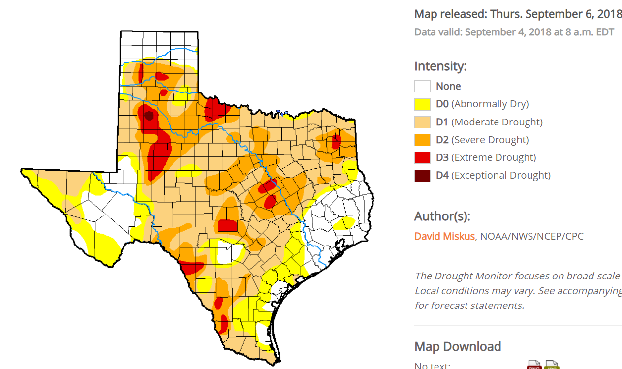
I'm thinking that the new USDM map to be released tomorrow will show a big reduction in drought coverage and severity across south and eastern Texas. Here in Houston, I've had 3 inches of rain in the last 36 hours. We CERTAINLY do not need a tropical system of any sort, as we're dealing with a huge swath of tropical moisture over the next few days as it is. Currently under a flash flood watch. If we get another round of significant rainfall late this week, I'll be boating to work!
1 likes

Re: NW Carib. Sea toward Western Gulf
Lots of convergence and divergence in the GoH. Very little vortices at any level though. Shear induced for sure but might be changing.
http://tropic.ssec.wisc.edu/tropic.php
http://tropic.ssec.wisc.edu/tropic.php
0 likes
The following post is NOT an official forecast and should not be used as such. It is just the opinion of the poster and may or may not be backed by sound meteorological data. It is NOT endorsed by any professional institution including storm2k.org For Official Information please refer to the NHC and NWS products.
Re: NW Carib. Sea toward Western Gulf
GFS says 'hey South Texas, y'all want some rain'
0 likes
Personal Forecast Disclaimer:
The posts in this forum are NOT official forecast and should not be used as such. They are just the opinion of the poster and may or may not be backed by sound meteorological data. They are NOT endorsed by any professional institution or storm2k.org. For official information, please refer to the NHC and NWS products.
The posts in this forum are NOT official forecast and should not be used as such. They are just the opinion of the poster and may or may not be backed by sound meteorological data. They are NOT endorsed by any professional institution or storm2k.org. For official information, please refer to the NHC and NWS products.

-
cycloneye

- Admin

- Posts: 149368
- Age: 69
- Joined: Thu Oct 10, 2002 10:54 am
- Location: San Juan, Puerto Rico
Re: NW Carib. Sea toward Western Gulf (Is INVEST 95L)
1 likes
Visit the Caribbean-Central America Weather Thread where you can find at first post web cams,radars
and observations from Caribbean basin members Click Here
and observations from Caribbean basin members Click Here
Who is online
Users browsing this forum: NotSparta and 166 guests