12:00 PM AST Mon Sep 10
Location: 25.0°N 60.2°W
Moving: W at 13 mph
Min pressure: 946 mb
Max sustained: 130 mph
ATL: FLORENCE - Post-Tropical - Discussion
Moderator: S2k Moderators
Re: ATL: FLORENCE - Hurricane - Discussion
0 likes


Re: ATL: FLORENCE - Hurricane - Discussion
We'll probably see recon continuously find her stronger with each pass. She is still intensifying at a good rate.
Working on a W ring with WMG.
Working on a W ring with WMG.
1 likes
The above post and any post by Ntxw is NOT an official forecast and should not be used as such. It is just the opinion of the poster and may or may not be backed by sound meteorological data. It is NOT endorsed by any professional institution including Storm2k. For official information, please refer to NWS products.
Help support Storm2K!

-
tatertawt24
- Category 1

- Posts: 309
- Joined: Wed Oct 24, 2012 12:57 pm
Re: ATL: FLORENCE - Hurricane - Discussion
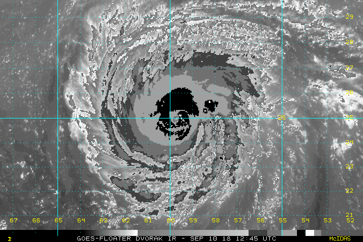
cheezyWXguy wrote:Florence is making some pretty solid progress of developing a ring of -69C to -75C cloud temps around its eye. Im not all that familiar with the dvorak technique, but isn't that closing in on 6.0?
This seems like a decent page for Dvorak updates.
http://tropic.ssec.wisc.edu/real-time/adt/odt06L.html
0 likes
Personal Forecast Disclaimer:
The posts in this forum are NOT official forecast and should not be used as such. They are just the opinion of the poster and may or may not be backed by sound meteorological data. They are NOT endorsed by any professional institution or storm2k.org. For official information, please refer to the NHC and NWS products.
The posts in this forum are NOT official forecast and should not be used as such. They are just the opinion of the poster and may or may not be backed by sound meteorological data. They are NOT endorsed by any professional institution or storm2k.org. For official information, please refer to the NHC and NWS products.
-
meriland29

- Category 2

- Posts: 770
- Joined: Thu Aug 03, 2017 11:05 am
Re: ATL: FLORENCE - Hurricane - Discussion
Next NHC discussion will be extremely interesting...
0 likes
-
plasticup
Re: ATL: FLORENCE - Hurricane - Discussion
Ntxw wrote:We'll probably see recon continuously find her stronger with each pass. She is still intensifying at a good rate.
[im g]https://images2.imgbox.com/d6/7a/Lecva3wa_o.gif[/img]
Working on a W ring with WMG.
Do you think they'll go through a third time?
0 likes
-
mcheer23

- Professional-Met

- Posts: 441
- Age: 32
- Joined: Sun Jun 24, 2012 8:24 pm
- Location: Sugar Land, Texas
Re: ATL: FLORENCE - Hurricane - Discussion
We'll see if its just a jog, but she is finally north of 25.0....
2 likes

Re: ATL: FLORENCE - Hurricane - Discussion
Product: NOAA Vortex Message (URNT12 KWBC)
A. Time of Center Fix: 10th day of the month at 16:42:37Z
B. Center Fix Coordinates: 25.07N 60.31W
D. Minimum Sea Level Pressure: 943mb (27.85 inHg) - Extrapolated
F. Eye Character: Closed
G. Eye Shape & Diameter: Circular with a diameter of 12 nautical miles (14 statute miles)
H. Estimated (by SFMR or visually) Maximum Surface Wind Inbound: 114kts (131.2mph)
I. Location & Time of the Estimated Maximum Surface Wind Inbound: 9 nautical miles to the NE (41°) of center fix at 16:40:11Z
L. Estimated (by SFMR or visually) Maximum Surface Wind Outbound: 125kts (143.8mph)
M. Location & Time of the Estimated Maximum Surface Wind Outbound: 8 nautical miles to the S (183°) of center fix at 16:44:30Z
P. Maximum Flight Level Temp & Pressure Altitude Outside Eye: 14°C (57°F) at a pressure alt. of 2,332m (7,651ft)
Q. Maximum Flight Level Temp & Pressure Altitude Inside Eye: 19°C (66°F) at a pressure alt. of 2,813m (9,229ft)
Remarks Section:
Sea Level Pressure Extrapolation From: 700mb
Maximum Flight Level Wind: 132kts (~ 151.9mph) which was observed 12 nautical miles (14 statute miles) to the NE (54°) from the flight level center at 15:38:15Z
0 likes
Re: ATL: FLORENCE - Hurricane - Discussion
mcheer23 wrote:We'll see if its just a jog, but she is finally north of 25.0....
Is it now where NHC expected it to be?
1 likes
-
MississippiWx

- S2K Supporter

- Posts: 1720
- Joined: Sat Aug 14, 2010 1:44 pm
- Location: Hattiesburg, Mississippi
Re: ATL: FLORENCE - Hurricane - Discussion
Looks like she may have strengthened to ~140mph.
0 likes
This post is not an official forecast and should not be used as such. It is just the opinion of MississippiWx and may or may not be backed by sound meteorological data. It is not endorsed by any professional institution including storm2k.org. For Official Information please refer to the NHC and NWS products.

-
Hypercane_Kyle

- Category 5

- Posts: 3465
- Joined: Sat Mar 07, 2015 7:58 pm
- Location: Cape Canaveral, FL
Re: ATL: FLORENCE - Hurricane - Discussion
Yea, definitely a jog to the WNW between the two VDMs. Reminds to be seen if just a trend, rapidly intensifying hurricanes do tend to jump around a lot.
0 likes
My posts are my own personal opinion, defer to the National Hurricane Center (NHC) and other NOAA products for decision making during hurricane season.
-
SunnyThoughts
- Category 5
- Posts: 2263
- Joined: Wed Jul 09, 2003 12:42 pm
- Location: Pensacola, Florida

-
nativefloridian

- Tropical Storm

- Posts: 172
- Joined: Tue Aug 21, 2012 2:48 pm
- Location: Pembroke Pines, FL
Re: ATL: FLORENCE - Hurricane - Discussion
GCANE wrote:Product: NOAA Vortex Message (URNT12 KWBC)
A. Time of Center Fix: 10th day of the month at 16:42:37Z
B. Center Fix Coordinates: 25.07N 60.31W
D. Minimum Sea Level Pressure: 943mb (27.85 inHg) - Extrapolated
F. Eye Character: Closed
G. Eye Shape & Diameter: Circular with a diameter of 12 nautical miles (14 statute miles)
H. Estimated (by SFMR or visually) Maximum Surface Wind Inbound: 114kts (131.2mph)
I. Location & Time of the Estimated Maximum Surface Wind Inbound: 9 nautical miles to the NE (41°) of center fix at 16:40:11Z
L. Estimated (by SFMR or visually) Maximum Surface Wind Outbound: 125kts (143.8mph)
M. Location & Time of the Estimated Maximum Surface Wind Outbound: 8 nautical miles to the S (183°) of center fix at 16:44:30Z
P. Maximum Flight Level Temp & Pressure Altitude Outside Eye: 14°C (57°F) at a pressure alt. of 2,332m (7,651ft)
Q. Maximum Flight Level Temp & Pressure Altitude Inside Eye: 19°C (66°F) at a pressure alt. of 2,813m (9,229ft)
Remarks Section:
Sea Level Pressure Extrapolation From: 700mb
Maximum Flight Level Wind: 132kts (~ 151.9mph) which was observed 12 nautical miles (14 statute miles) to the NE (54°) from the flight level center at 15:38:15Z
Ok....I'm confused. You posted the following message an hour ago. So I'm assuming the Center Coordinates will fluctuate depending on the transmittal time? Thanks for clarifying.
#1773 Postby GCANE » Mon Sep 10, 2018 12:11 pm
Product: NOAA Vortex Message (URNT12 KWBC)
Transmitted: 10th day of the month at 16:04Z
A. Time of Center Fix: 10th day of the month at 15:35:18Z
B. Center Fix Coordinates: 24.99N 60.14W
D. Minimum Sea Level Pressure: 947mb (27.97 inHg)
E. Dropsonde Surface Wind at Center: From 50° at 9kts (From the NE at 10mph)
F. Eye Character: Closed
G. Eye Shape & Diameter: Circular with a diameter of 12 nautical miles (14 statute miles)
H. Estimated (by SFMR or visually) Maximum Surface Wind Inbound: 113kts (130.0mph)
I. Location & Time of the Estimated Maximum Surface Wind Inbound: 6 nautical miles to the SW (235°) of center fix at 15:33:37Z
L. Estimated (by SFMR or visually) Maximum Surface Wind Outbound: 119kts (136.9mph)
M. Location & Time of the Estimated Maximum Surface Wind Outbound: 12 nautical miles (14 statute miles) to the NE (54°) of center fix at 15:38:13Z
P. Maximum Flight Level Temp & Pressure Altitude Outside Eye: 14°C (57°F) at a pressure alt. of 2,391m (7,844ft)
Q. Maximum Flight Level Temp & Pressure Altitude Inside Eye: 20°C (68°F) at a pressure alt. of 2,785m (9,137ft)
Remarks Section:
Maximum Flight Level Wind: 132kts (~ 151.9mph) which was observed 12 nautical miles (14 statute miles) to the NE (54°) from the flight level center at 15:38:15Z
0 likes
-
supercane4867
- Category 5
- Posts: 4966
- Joined: Wed Nov 14, 2012 10:43 am
Re: ATL: FLORENCE - Hurricane - Discussion
Significant CDO cooling going on. She's pushing toward T7.0
0 likes
-
tatertawt24
- Category 1
- Posts: 309
- Joined: Wed Oct 24, 2012 12:57 pm
Re: ATL: FLORENCE - Hurricane - Discussion
GOES-16 is the best weather invention since the barometer. <3
http://rammb.cira.colostate.edu/ramsdis/online/loop.asp?data_folder=loop_of_the_day/goes-16/20180910000000&number_of_images_to_display=400&loop_speed_ms=25
http://rammb.cira.colostate.edu/ramsdis/online/loop.asp?data_folder=loop_of_the_day/goes-16/20180910000000&number_of_images_to_display=400&loop_speed_ms=25
1 likes
Personal Forecast Disclaimer:
The posts in this forum are NOT official forecast and should not be used as such. They are just the opinion of the poster and may or may not be backed by sound meteorological data. They are NOT endorsed by any professional institution or storm2k.org. For official information, please refer to the NHC and NWS products.
The posts in this forum are NOT official forecast and should not be used as such. They are just the opinion of the poster and may or may not be backed by sound meteorological data. They are NOT endorsed by any professional institution or storm2k.org. For official information, please refer to the NHC and NWS products.
-
Aric Dunn
- Category 5
- Posts: 21238
- Age: 43
- Joined: Sun Sep 19, 2004 9:58 pm
- Location: Ready for the Chase.
- Contact:
Re: ATL: FLORENCE - Hurricane - Discussion
that jog wnw right at the same time of a that convective burst. could be related to that. need to wait and see.
0 likes
Note: If I make a post that is brief. Please refer back to previous posts for the analysis or reasoning. I do not re-write/qoute what my initial post said each time.
If there is nothing before... then just ask
Space & Atmospheric Physicist, Embry-Riddle Aeronautical University,
I believe the sky is falling...
If there is nothing before... then just ask
Space & Atmospheric Physicist, Embry-Riddle Aeronautical University,
I believe the sky is falling...
-
jlauderdal
- S2K Supporter
- Posts: 7240
- Joined: Wed May 19, 2004 5:46 am
- Location: NE Fort Lauderdale
- Contact:
Re: RE: Re: ATL: FLORENCE - Hurricane - Discussion
You have recon, i suggest using that.tatertawt24 wrote:cheezyWXguy wrote:Florence is making some pretty solid progress of developing a ring of -69C to -75C cloud temps around its eye. Im not all that familiar with the dvorak technique, but isn't that closing in on 6.0?
This seems like a decent page for Dvorak updates.
http://tropic.ssec.wisc.edu/real-time/adt/odt06L.html
0 likes

Re: ATL: FLORENCE - Hurricane - Discussion
Florence is stair stepping at the moment, 3hrs more Westerly followed by a d cent WNW jog. Longer term average probably around 280.
I think the NHC track is good but maybe it will end up a touch right as that is pretty typical of storms with northward motion.
I think the NHC track is good but maybe it will end up a touch right as that is pretty typical of storms with northward motion.
1 likes
Personal Forecast Disclaimer:
The posts in this forum are NOT official forecast and should not be used as such. They are just the opinion of the poster and may or may not be backed by sound meteorological data. They are NOT endorsed by any professional institution or storm2k.org. For official information, please refer to the NHC and NWS products
The posts in this forum are NOT official forecast and should not be used as such. They are just the opinion of the poster and may or may not be backed by sound meteorological data. They are NOT endorsed by any professional institution or storm2k.org. For official information, please refer to the NHC and NWS products
Re: ATL: FLORENCE - Hurricane - Discussion
Aric Dunn wrote:that jog wnw right at the same time of a that convective burst. could be related to that. need to wait and see.
When was NHC forecasting the start of wnw turn?
0 likes
-
jlauderdal
- S2K Supporter
- Posts: 7240
- Joined: Wed May 19, 2004 5:46 am
- Location: NE Fort Lauderdale
- Contact:
Re: RE: Re: ATL: FLORENCE - Hurricane - Discussion
Every nhc discussion is interesting and is a must to fully understand the past and futuremeriland29 wrote:Next NHC discussion will be extremely interesting...
1 likes
Who is online
Users browsing this forum: No registered users and 28 guests