
Please post any evacuation orders, closings and nws warnings, observations here.
Prepare early, leave if ordered, and in doubt of low lying areas, and know you all are in our thoughts and prayers.
Be sure to check in as soon as you can, once power and cell service is restored.
Mods, can you sticky, please?
Local Impact Statements
https://www.nhc.noaa.gov/text/refresh/i ... 1230.shtml
South Carolina local station
http://www.wistv.com/
Cape Fear region
http://wwaytv3.com/
Myrtle Beach area
https://www.wbtw.com/
North Carolina. Raleigh-Durham
https://abc11.com/
Ocean City, Md area
http://www.wmdt.com/
Virginia/NC live news stream
https://www.wavy.com/video/live-stream- ... 1431593708
Some pages have multiple links to different cameras
Frying Pan Ocean Cam: https://www.youtube.com/watch?v=deG4Nxk ... e=youtu.be
https://www.earthcam.com/usa/southcarol ... awahisland
https://www.wral.com/north_carolina_webcams/10997074/
https://the-windjammer.com/jammer-cams/
https://southcarolinaparks.com/webcams/edisto-beach
http://www.wistv.com/story/5314481/sout ... na-webcams
https://www.baysider.com/Webcams/United ... nia_Beach/
https://wgsc.beachtv.tv/m/kJQiYAxG/mars ... t=Qf0oOLHC
https://www.vbbound.com/live-webcam-of- ... -boardwalk
https://www.nps.gov/shen/learn/photosmu ... webcam.htm
http://sandbridgehouses.com/webcam/
https://oceancitylive.com/
Ga
http://www.beachcamsusa.com/ga/saint-si ... ier-webcam
ATL: FLORENCE - Evacuations, Closings, Webcams, Observations
Moderator: S2k Moderators
Forum rules

The posts in this forum are NOT official forecasts and should not be used as such. They are just the opinion of the poster and may or may not be backed by sound meteorological data. They are NOT endorsed by any professional institution or STORM2K. For official information, please refer to products from the National Hurricane Center and National Weather Service.
ATL: FLORENCE - Evacuations, Closings, Webcams, Observations
Last edited by artist on Tue Sep 11, 2018 1:00 pm, edited 12 times in total.
3 likes
Re: Florence Evacuations, Closings, Observations
https://www.thestate.com/news/state/sou ... 23955.html
September 10, 2018 02:36 PM
PINE RIDGE, SC
S.C. Gov. Henry McMaster announced a mandatory evacuation of the South Carolina coast on Monday.
Eight counties along the coast would begin evacuating as of noon on Tuesday, McMaster said at a press briefing on Monday.
McMaster said he would reverse lanes on four main roads to facilitate the evacuation. As many as a million people could leave the coast because of the order, the governor said.
“We know the evacuation order I’m issuing will be inconvenient,” McMaster said. “But we’re not going to gamble with the lives of the people of South Carolina.”
Read more here: https://www.thestate.com/news/state/sou ... rylink=cpy
0 likes
Re: Florence Evacuations, Closings, Observations
http://www.whsv.com/content/news/Evacua ... 65191.html
Dare County, the easternmost county in North Carolina, issued a state of emergency Monday morning and says all visitors and residents of Hatteras Island are under mandatory evacuations starting at noon. This includes the villages of Rodanthe, Waves, Salvo, Avon, Buxton, Frisco, and Hatteras Village.
The rest of Dare County will be under evacuation orders starting at 7:00 a.m. Tuesday.
The state of emergency also restricts swimming in the ocean as county officials say dangerous surf conditions make the ocean unsafe for even the most experienced swimmers.
To the southwest, the University of North Carolina Wilmington issued a voluntary evacuation for students starting Monday at noon, canceling classes from that point until further notice.
0 likes
-
NC George

- Category 2

- Posts: 635
- Age: 56
- Joined: Sun Sep 14, 2003 11:44 am
- Location: Washington, NC, USA
Re: ATL: FLORENCE - Evacuations, Closings, Webcams, Observations
East Carolina University cancelled classes for the rest of the week starting Tuesday at noon.
http://www.witn.com/content/news/ECU-ca ... 74701.html
http://www.witn.com is a good source for all eastern NC related news and closures for the area N of Wilmington and S of Norfolk, VA.
http://www.witn.com/content/news/ECU-ca ... 74701.html
http://www.witn.com is a good source for all eastern NC related news and closures for the area N of Wilmington and S of Norfolk, VA.
1 likes
Bertha '96, Fran '96, Bonnie '98, Dennis '99, Floyd '99  , Isabel '03, Irene '11, Matthew '16, Isaias '20, PTC16????
Avatar is heading into Florence 2018, moving friend's boat, only land between us and Hurricane Florence is Ocracoke Island!
Avatar is heading into Florence 2018, moving friend's boat, only land between us and Hurricane Florence is Ocracoke Island!
Re: ATL: FLORENCE - Evacuations, Closings, Webcams, Observations
Briefing On Preparations for Hurricane Florence
The City of Virginia Beach held a media briefing at noon Monday, September 10 to talk about preparations in advance of Hurricane Florence. If you missed it, you can watch it on Facebook, https://www.facebook.com/CityofVaBeach/.
https://dailycaller.com/2018/09/09/virg ... nce-maria/
https://www.thedailybeast.com/navy-ship ... e-florence
http://www.vaemergency.gov/hurricane-ev ... ne-lookup/
0 likes
Re: ATL: FLORENCE - Evacuations, Closings, Webcams, Observations
School closings
Brunswick County schools - will be closed from Tuesday, Sept. 11 through Friday, Sept. 14. School-related activities scheduled during this time are canceled.
Brunswick Community College will be closed Tuesday, Sept. 11 through Saturday, Sept. 15 and will reopen on Monday, Sept. 17 pending local conditions.
Cape Fear Community College to close at 5 p.m. Monday and remain closed through Saturday, Sept. 15. All classes, events, and activities at all campus locations will be closed.
New Hanover County Schools - will be closed to students and most staff from Tuesday, Sept. 11 through Friday, Sept. 14. Identified NHCS staff, including senior staff, principals, custodians, and some others, will be required to work on Tuesday to secure the schools and make preparations throughout the school system. Supervisors will inform employees if they are identified for work Tuesday. All athletic events, practices, and related activities have been canceled.
Pender County Schools will be closed to students and non-essential staff on Tuesday, Sept. 11 through Friday, Sept. 14. All after-school activities, including the Pender County Board of Education Meeting, have been canceled.
UNCW - issued a mandatory evacuation for students starting effective at 8 a.m Tuesday, Sept. 11. Students must evacuate campus beginning at 8 a.m. on Tuesday, Sept. 11, and must leave campus no later than 12 p.m. on Tuesday, Sept. 11. (A voluntary evacuation remains in place until then.)
---
The Children's Schoolhouse Montessori Preschool - will be closed Tuesday through Friday
Cape Fear Academy will be closed Tues, Sept. 11 through Fri., Sept 14.
Cape Fear Center for Inquiry will be closed Tuesday, Sept. 11 through Friday, Sept. 14
Charter Day School in Leland will be closed for students and staff Tuesday, Sept. 11 through Friday, Sept. 14.
Columbus Charter School will be closed to students and staff Tuesday, Sept. 11 through Friday, Sept. 14.
Douglass Academy Charter will be closed to students and staff on Sept. 11 through Sept. 14.
Leland Christian Academy will be closed Sept. 11 through Sept. 14.
Myrtle Grove Christian School will be closed Sept. 11 through Sept. 14.
Puddle Jumpers Nature Preschool in Hampstead will be closed Sept. 11 through Sept. 14.
South Brunswick Charter School in Bolivia - will be closed for children, staff and AlphaBest all day Tuesday, Sept. 11 through Friday, Sept. 14.
Government closings
Brunswick County Courthouse will be closed from Tuesday, Sept. 11 through Friday, Sept. 14.
Brunswick Transit System will provide limited transportation services on Tuesday, Sept. 11 and will be closed Wednesday, Sept. 12 throgh Friday, Sept. 14. Regular services are expected to resume on Monday, Sept. 17, weather pending.
Town of Burgaw Board of Commissioners meeting scheduled for Tuesday has been canceled
Brunswick County has canceled the Brunswick County Veterans Services Tour events that were planned to begin Friday, Sept. 14
Moores Creek will be closed starting Monday, Sept. 10
New Hanover County offices and government buildings will close at 12 p.m. on Tuesday, Sept. 11. This includes county libraries, the Senior Resource Center, Airlie Gardens, the Arboretum, Cape Fear Museum, and county parks.
Southport/Ft. Fisher Ferry will not operate any runs beginning Sept. 11.
http://www.nbc12.com/story/39058503/clo ... e-florence
0 likes
-
MBismyPlayground

- S2K Supporter

- Posts: 765
- Joined: Mon Sep 06, 2004 9:25 pm
- Location: myrtle beach, sc
- Contact:
Re: ATL: FLORENCE - Evacuations, Closings, Webcams, Observations
https://mobile.twitter.com/SCEMD South Carolina Emergency Management District Twitter
https://mobile.twitter.com/NCEmergency North Carolina Emergency Management
https://mobile.twitter.com/vdem Virginia Emergency Management
https://mobile.twitter.com/GeorgiaEMA Georgia Emergency Management
https://mobile.twitter.com/NCEmergency North Carolina Emergency Management
https://mobile.twitter.com/vdem Virginia Emergency Management
https://mobile.twitter.com/GeorgiaEMA Georgia Emergency Management
Last edited by artist on Wed Sep 12, 2018 4:31 am, edited 1 time in total.
0 likes
-
cycloneye

- Admin

- Posts: 149720
- Age: 69
- Joined: Thu Oct 10, 2002 10:54 am
- Location: San Juan, Puerto Rico
Re: ATL: FLORENCE - Evacuations, Closings, Webcams, Observations
Local NWS offices information can be posted here too.
2 likes
Visit the Caribbean-Central America Weather Thread where you can find at first post web cams,radars
and observations from Caribbean basin members Click Here
and observations from Caribbean basin members Click Here
-
MBismyPlayground
- S2K Supporter
- Posts: 765
- Joined: Mon Sep 06, 2004 9:25 pm
- Location: myrtle beach, sc
- Contact:
Re: ATL: FLORENCE - Evacuations, Closings, Webcams, Observations
SCEMD Retweeted
SCDMV
SCDMV
@SC_DMV
·
24m
Planning a trip to the
#SCDMV
? Branches in 26 counties will be closed tomorrow. Visit (link: http://www.scdmvonline.com/Locations) scdmvonline.com/Locations to find out if your local branch is open. Also, Follow
@SCEMD
for up-to-date information on
#HurricaneFlorence
and for information on closings and delays.
SCEMD
SCEMD
@SCEMD
·
1h
“Evacuation shelters will be open tomorrow. Based on need.” Dir. Stenson, SCEMD
SCDMV
SCDMV
@SC_DMV
·
24m
Planning a trip to the
#SCDMV
? Branches in 26 counties will be closed tomorrow. Visit (link: http://www.scdmvonline.com/Locations) scdmvonline.com/Locations to find out if your local branch is open. Also, Follow
@SCEMD
for up-to-date information on
#HurricaneFlorence
and for information on closings and delays.
SCEMD
SCEMD
@SCEMD
·
1h
“Evacuation shelters will be open tomorrow. Based on need.” Dir. Stenson, SCEMD
0 likes
Re: ATL: FLORENCE - Evacuations, Closings, Webcams, Observations
NC Emergency Managem Retweeted
Dare County EM
Dare County EM
@DareCountyEM
·
1h
We highly recommend evacuees use Highway 64/264 and head to 1-95 to move North/South - Highway 158 will be very congested and 64/264 has less stoplights allowing for constant speed.
#OBX
#Hatteras
#Florence
#ncwx
3
41
28
NC Emergency Managem
NC Emergency Managem
@NCEmergency
·
4h
On top of following NC Emergency Management channels and downloading the ReadyNC app, find storm related resources on the NCDPS website. (link: http://ow.ly/xWPr30lL6td) ow.ly/xWPr30lL6td
#FlorenceNC
#ncwx
Dare County EM
Dare County EM
@DareCountyEM
·
1h
We highly recommend evacuees use Highway 64/264 and head to 1-95 to move North/South - Highway 158 will be very congested and 64/264 has less stoplights allowing for constant speed.
#OBX
#Hatteras
#Florence
#ncwx
3
41
28
NC Emergency Managem
NC Emergency Managem
@NCEmergency
·
4h
On top of following NC Emergency Management channels and downloading the ReadyNC app, find storm related resources on the NCDPS website. (link: http://ow.ly/xWPr30lL6td) ow.ly/xWPr30lL6td
#FlorenceNC
#ncwx
0 likes
Re: ATL: FLORENCE - Evacuations, Closings, Webcams, Observations
FOR IMMEDIATE RELEASE
Date: September 10, 2018
Contact: Julie Buchanan, Senior P.R. & Marketing Specialist, (804) 786-2292, julie.buchanan@dcr.virginia.gov
Russ Baxter, Deputy Director for Soil and Water Conservation, Dam Safety and Floodplain Management, (804) 786-2291, russ.baxter@dcr.virginia.gov
Advisory to Virginia Dam Owners ahead of Hurricane Florence
RICHMOND, Va. — As of Monday Sept. 10, the National Weather Service has forecasted the potential for a major hurricane-level storm event in Virginia within the next week. Rainfall projections are currently forecasted to be from approximately 10 to 20 inches in some areas of the state if the storm were to slow down or “stall.”
In preparation for this potential storm event, the Virginia Department of Conservation and Recreation Dam Safety Program is offering the following information to dam owners.
1. Reach out to your professional engineer and discuss the specifics of your dam and what to do during an emergency situation.
2. Locate and review your dam's emergency action plan if one is in place. Ensure that all contacts and contact information are up-to-date. Provide any updates to the local emergency services contact and DCR Dam Safety.
3. If your dam has a working low-flow valve, you as the dam owner should consider consulting with your professional engineer about possibly lowering your lake level by up to 6 inches per day (24-hour period). By lowering the normal water level in your lake, you provide extra storage for when rainfall begins. Note that lowering lake levels by more than 6 inches per day is not allowed as rapid drawdown of a lake level could result in critical damage to your dam.
4. Visually inspect your dam and remove any debris from the primary and emergency spillways. Contact your professional engineer if any dam-related issues are found (seepage, slope failures, rodent holes, etc.)
For information about the Virginia Dam Safety Program, go to www.dcr.virginia.gov/dam-safety-and-floodplains/.
http://www.dcr.virginia.gov/pr-relz-det ... 174403-tqj
0 likes
-
CyclonicFury

- Category 5

- Posts: 2038
- Age: 27
- Joined: Sun Jul 02, 2017 12:32 pm
- Location: NC
- Contact:
Re: ATL: FLORENCE - Evacuations, Closings, Webcams, Observations
NCSU closed for Thursday and Friday this week
0 likes
NCSU B.S. in Meteorology Class of 2021. Tropical weather blogger at http://www.cyclonicfury.com. My forecasts and thoughts are NOT official, for official forecasts please consult the National Hurricane Center.
Re: ATL: FLORENCE - Evacuations, Closings, Webcams, Observations
VDEM
VDEM
@VDEM
·
21m
Governor Northam orders the coastal evacuation of Zone A, the lowest-lying areas of Coastal Virginia and the Eastern Shore, effective 8 a.m. tomorrow (9/11).
Call 2-1-1 to learn your zone or visit (link: http://vdemgis.sharedalink.info/gBet1Yx) vdemgis.sharedalink.info/gBet1Yx.
Zone A residence should move to higher ground.
0 likes
Re: ATL: FLORENCE - Evacuations, Closings, Webcams, Observations
VDOT Hampton Roads
@VaDOTHR
The VDOT Hampton Roads District is suspending lane closures on Interstate 64 and Interstate 664 starting Monday at 6 p.m., in anticipation of increased travel demand due to Hurricane
#Florence
. The suspension will remain in effect until the emergency is over.
#vawx
(1/2
@VaDOTHR
The VDOT Hampton Roads District is suspending lane closures on Interstate 64 and Interstate 664 starting Monday at 6 p.m., in anticipation of increased travel demand due to Hurricane
#Florence
. The suspension will remain in effect until the emergency is over.
#vawx
(1/2
0 likes
Re: ATL: FLORENCE - Evacuations, Closings, Webcams, Observations
Please, please, please take your pets. Don’t leave them to fend for themselves.
0 likes
Re: ATL: FLORENCE - Evacuations, Closings, Webcams, Observations
DEM Retweeted
National Hurricane Center
National Hurricane Center
@NHC_Atlantic
·
3h
Hurricane
#Florence
is not just a threat to the coast. Very heavy, prolonged rainfall is expected over a large portion of the Carolinas and mid-Atlantic. Here is the latest 7 day rainfall forecast from
@NWSWPC
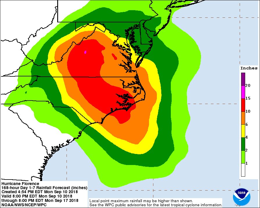
National Hurricane Center
National Hurricane Center
@NHC_Atlantic
·
3h
Hurricane
#Florence
is not just a threat to the coast. Very heavy, prolonged rainfall is expected over a large portion of the Carolinas and mid-Atlantic. Here is the latest 7 day rainfall forecast from
@NWSWPC
0 likes
-
Syx6sic
- Tropical Depression

- Posts: 84
- Age: 41
- Joined: Wed Jun 05, 2013 12:11 pm
- Location: Virginia beach VA
Re: ATL: FLORENCE - Evacuations, Closings, Webcams, Observations
PORTSMOUTH, Va. (WAVY) -- Area schools are closing as Hurricane Florence -- now a Category 4 storm -- heads toward the East Coast.
Here are the list of area schools that are closing:
Virginia Beach Public Schools (Closed starting Thursday). Students whose families live in Zone A and are evacuating Tuesday will be excused from classes. Kellam High, Old Donation School and Corporate Landing will open as emergency shelters.
Chesapeake Public Schools (Closed until further notice starting Tuesday)
Currituck Public Schools (Closed Tuesday through Friday)
Dare Public Schools (Closed Tuesday through Friday)
Elizabeth City-Pasquotank Public Schools (Closed Wednesday through Friday)
Gloucester County Public Schools (Closed until further notice starting Tuesday)
Mathews County Public Schools (Closed Tuesday through Friday)
Newport News Public Schools (Closed until further notice starting Tuesday)
Norfolk Collegiate School (Closed until further notice starting Tuesday)
Norfolk Public Schools (Closed until further notice starting Tuesday)
Northampton County Public Schools (Closed until further notice starting Tuesday)
Hampton Public Schools (Closed until further notice starting Tuesday)
Portsmouth Public Schools (Closed until further notice starting Tuesday)
York County Public Schools (Closed until further notice starting Tuesday)
Know Your Zone: Mandatory evacuation issued for Zone A in Virginia
WAVY.com Hurricane Guide: If You Evacuate
Suffolk Public Schools haven't officially announced closings at this time.
Check back for updates.
0 likes
Personal Forecast Disclaimer:
The posts in this forum are NOT official forecast and should not be used as such. They are just the opinion of the poster and may or may not be backed by sound meteorological data. They are NOT endorsed by any professional institution or storm2k.org. For official information, please refer to the NHC and NWS products.
The posts in this forum are NOT official forecast and should not be used as such. They are just the opinion of the poster and may or may not be backed by sound meteorological data. They are NOT endorsed by any professional institution or storm2k.org. For official information, please refer to the NHC and NWS products.
Who is online
Users browsing this forum: No registered users and 131 guests