ATL: INVEST 95L - Models
Moderator: S2k Moderators
-
South Texas Storms

- Professional-Met

- Posts: 4256
- Joined: Thu Jun 24, 2010 12:28 am
- Location: Houston, TX

Re: ATL: INVEST 95L - Models
0 likes
Personal Forecast Disclaimer:
The posts in this forum are NOT official forecast and should not be used as such. They are just the opinion of the poster and may or may not be backed by sound meteorological data. They are NOT endorsed by any professional institution or storm2k.org. For official information, please refer to the NHC and NWS products.
The posts in this forum are NOT official forecast and should not be used as such. They are just the opinion of the poster and may or may not be backed by sound meteorological data. They are NOT endorsed by any professional institution or storm2k.org. For official information, please refer to the NHC and NWS products.
-
wxman22

- Category 5

- Posts: 1920
- Joined: Mon Jan 30, 2006 12:39 am
- Location: Wichita Falls, TX
- Contact:
Re: ATL: INVEST 95L - Models
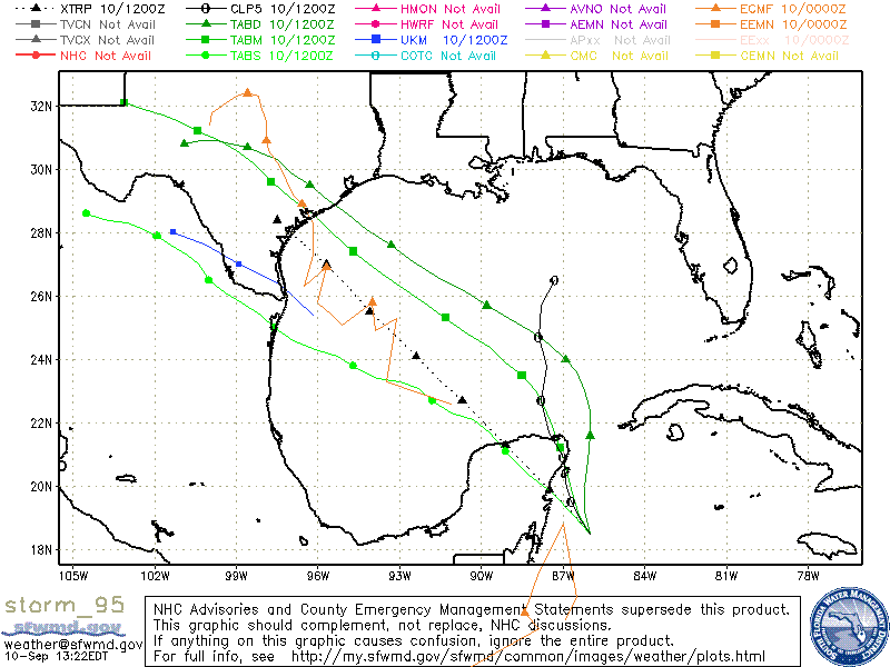
The 12z Canadian develops it into a Depression with most of the moisture displaced to the northeast of the center, across the middle and upper Texas coast. It shows heavy rain in southeast Texas and central Texas fwiw
Last edited by wxman22 on Mon Sep 10, 2018 12:47 pm, edited 2 times in total.
1 likes

Re: ATL: INVEST 95L - Models
SHIPS forecasts it to be around 50 knots as it makes landfall near Matagorda Bay, it will have fairly good UL Conditions over the NW GOM.
Code: Select all
 * ATLANTIC     2018 SHIPS INTENSITY FORECAST     *
                    * IR SAT DATA AVAILABLE,       OHC AVAILABLE     *
                    *  INVEST      AL952018  09/10/18  12 UTC        *

TIME (HR)          0     6    12    18    24    36    48    60    72    84    96   108   120
V (KT) NO LAND    25    25    25    25    25    27    29    35    38    44    48    53    56
V (KT) LAND       25    25    25    25    23    28    29    35    39    44    48    46    34
V (KT) LGEM       25    25    25    25    22    25    25    27    29    32    36    40    30
Storm Type      TROP  TROP  TROP  TROP  TROP  TROP  TROP  TROP  TROP  TROP  TROP  TROP  TROP

SHEAR (KT)        23    14    17    23    21    17    18     7    13     3    10     6     8
SHEAR ADJ (KT)    -2     4     6     0    -1     0    -3    -3    -5    -2    -6    -6    -6
SHEAR DIR        262   274   257   278   304   299   335   317   351   305   346   267   330
SST (C)         29.9  29.6  29.4  29.2  29.1  29.0  29.5  30.1  30.1  30.3  29.8  29.3  29.1
POT. INT. (KT)   165   161   158   154   152   150   159   170   171   171   166   156   152
ADJ. POT. INT.   150   150   145   139   137   133   141   152   153   156   146   135   130
200 MB T (C)   -54.0 -53.8 -53.5 -53.9 -54.0 -53.4 -53.6 -53.2 -53.3 -52.9 -52.8 -52.3 -52.4
200 MB VXT (C)   0.2   0.3   0.1   0.0   0.1   0.3  -0.2  -0.3  -0.4  -0.3  -0.3  -0.4  -0.3
TH_E DEV (C)       8    10    11    10    10    10    10    10     9    10     9    11     9
700-500 MB RH     71    69    69    66    65    65    66    67    67    68    68    64    62
MODEL VTX (KT)     5     6     5     5     4     5     4     5     4     4     4     3     3
850 MB ENV VOR   -31   -25   -24   -38   -43   -23   -28   -18   -25   -22   -48   -44   -39
200 MB DIV        54    72    64    38    12    35    34     6     3     8    -5     4   -12
700-850 TADV       4    10     8     2     3     4    -2     1    -2     4     0     3     1
LAND (KM)        165   114    70    20   -21   103   217   346   425   365   170    -4  -185
LAT (DEG N)     18.5  19.1  19.9  20.6  21.2  22.5  23.5  24.4  25.3  26.3  27.4  28.6  29.6
LONG(DEG W)     86.0  86.4  86.7  86.9  87.1  87.7  88.5  89.7  91.3  93.0  94.7  96.2  97.7
STM SPEED (KT)     4     8     8     7     7     6     7     8     9     9    10     9     8
HEAT CONTENT      56    60    53    40    31    29    48    58    60    68    78    70     9
0 likes
-
stormlover2013
Re: ATL: INVEST 95L - Models
wxman22 wrote:The 12z Canadian develops it into a Depression with most of the moisture displaced to the northeast of the center, across the middle and upper Texas coast. It shows heavy rain in southeast Texas and central Texas fwiw
CMC smh I don't even watch it anymore..everytime I think its getting better it goes back to normal.
0 likes
Re: ATL: INVEST 95L - Models
Euro looks to be coming a little further south and more organized of the last run. Not done with the run yet though.
0 likes
Personal Forecast Disclaimer:
The posts in this forum are NOT official forecast and should not be used as such. They are just the opinion of the poster and may or may not be backed by sound meteorological data. They are NOT endorsed by any professional institution or storm2k.org. For official information, please refer to the NHC and NWS products.
The posts in this forum are NOT official forecast and should not be used as such. They are just the opinion of the poster and may or may not be backed by sound meteorological data. They are NOT endorsed by any professional institution or storm2k.org. For official information, please refer to the NHC and NWS products.
-
supercane4867
- Category 5
- Posts: 4966
- Joined: Wed Nov 14, 2012 10:43 am

-
Portastorm

- Storm2k Moderator

- Posts: 9955
- Age: 63
- Joined: Fri Jul 11, 2003 9:16 am
- Location: Round Rock, TX
- Contact:
Re: ATL: INVEST 95L - Models
SoupBone wrote:Euro looks to be coming a little further south and more organized of the last run. Not done with the run yet though.
12z Euro looks to bring whatever it is ashore around Baffin Bay late Friday evening.
1 likes
Any forecasts under my name are to be taken with a grain of salt. Get your best forecasts from the National Weather Service and National Hurricane Center.

Re: ATL: INVEST 95L - Models
Most of the ensemble members from the Euro have shifted into STX and NMX so it could be less rain for Texas overall compared to the 0z.
0 likes
-
mcheer23

- Professional-Met
- Posts: 441
- Age: 32
- Joined: Sun Jun 24, 2012 8:24 pm
- Location: Sugar Land, Texas
Re: ATL: INVEST 95L - Models
Cpv17 wrote:Most of the ensemble members from the Euro have shifted into STX and NMX so it could be less rain for Texas overall compared to the 0z.
This is a very lopsided system. All the rain will be on the right side.
Biggest threat from this system is heavy rain that will spread somewhere on the TX coast
1 likes
-
stormlover2013
Re: ATL: INVEST 95L - Models
will keep going back and forth till we have a center....prob will be sloppy....
0 likes
-
catskillfire51
- S2K Supporter

- Posts: 480
- Age: 39
- Joined: Sun Aug 26, 2012 5:40 pm
- Location: Lake Jackson, TX
Re: ATL: INVEST 95L - Models
GFS still shows nothing with this, maybe tomorrow if it keeps organizing.
0 likes


Re: ATL: INVEST 95L - Models
wkwally wrote:Any idea on how strong 95L might be before landfall?
Euro (which is running right now) is showing 1007mb and is coming in a bit further south of its previous run. I'm on my phone so it's hard to spot exactly where, but it's a bit further south of Corpus Christi.
0 likes
Personal Forecast Disclaimer:
The posts in this forum are NOT official forecast and should not be used as such. They are just the opinion of the poster and may or may not be backed by sound meteorological data. They are NOT endorsed by any professional institution or storm2k.org. For official information, please refer to the NHC and NWS products.
The posts in this forum are NOT official forecast and should not be used as such. They are just the opinion of the poster and may or may not be backed by sound meteorological data. They are NOT endorsed by any professional institution or storm2k.org. For official information, please refer to the NHC and NWS products.
Re: ATL: INVEST 95L - Models
SoupBone wrote:wkwally wrote:Any idea on how strong 95L might be before landfall?
Euro (which is running right now) is showing 1007mb and is coming in a bit further south of its previous run. I'm on my phone so it's hard to spot exactly where, but it's a bit further south of Corpus Christi.
Thanks a little jumpy here in Houston as we are still trying to recover from Harvey.
0 likes
Re: ATL: INVEST 95L - Models
wkwally wrote:SoupBone wrote:wkwally wrote:Any idea on how strong 95L might be before landfall?
Euro (which is running right now) is showing 1007mb and is coming in a bit further south of its previous run. I'm on my phone so it's hard to spot exactly where, but it's a bit further south of Corpus Christi.
Thanks a little jumpy here in Houston as we are still trying to recover from Harvey.
Understandable. But remember this is a single run of one model. Still time for things to change.
0 likes
Personal Forecast Disclaimer:
The posts in this forum are NOT official forecast and should not be used as such. They are just the opinion of the poster and may or may not be backed by sound meteorological data. They are NOT endorsed by any professional institution or storm2k.org. For official information, please refer to the NHC and NWS products.
The posts in this forum are NOT official forecast and should not be used as such. They are just the opinion of the poster and may or may not be backed by sound meteorological data. They are NOT endorsed by any professional institution or storm2k.org. For official information, please refer to the NHC and NWS products.
Re: ATL: INVEST 95L - Models
SoupBone wrote:wkwally wrote:SoupBone wrote:
Euro (which is running right now) is showing 1007mb and is coming in a bit further south of its previous run. I'm on my phone so it's hard to spot exactly where, but it's a bit further south of Corpus Christi.
Thanks a little jumpy here in Houston as we are still trying to recover from Harvey.
Understandable. But remember this is a single run of one model. Still time for things to change.
Will be watching the models closely
0 likes
Re: ATL: INVEST 95L - Models
The ensembles are mainly clustered together in between Baffin Bay and Port Aransas.
1 likes
-
South Texas Storms
- Professional-Met
- Posts: 4256
- Joined: Thu Jun 24, 2010 12:28 am
- Location: Houston, TX
Re: ATL: INVEST 95L - Models
I'm not sure why there aren't any hurricane models being run on this disturbance. Curious to see what the HWRF and HMON would show.
3 likes
-
stormlover2013
Re: ATL: INVEST 95L - Models
Will have better idea tomorrow, I’m interested to see what happens with it today
0 likes
Who is online
Users browsing this forum: No registered users and 37 guests