TY 1822 (Mangkhut)
Issued at 03:45 UTC, 11 September 2018
<Analysis at 03 UTC, 11 September>
Scale -
Intensity Very strong
Center position N13°55' (13.9°)
E140°35' (140.6°)
Direction and speed of movement W 25 km/h (14 kt)
Central pressure 925 hPa
Maximum wind speed near center 50 m/s (100 kt)
Maximum wind gust speed 70 m/s (140 kt)
≥ 50 kt wind area ALL 170 km (90 NM)
≥ 30 kt wind area ALL 330 km (180 NM)
WPAC: MANGKHUT - Post-Tropical
Moderator: S2k Moderators
-
xtyphooncyclonex

- Category 5

- Posts: 3891
- Age: 24
- Joined: Sat Dec 08, 2012 9:07 am
- Location: Cebu City
- Contact:
Re: WPAC: MANGKHUT - Typhoon
1 likes
REMINDER: My opinions that I, or any other NON Pro-Met in this forum, are unofficial. Please do not take my opinions as an official forecast and warning. I am NOT a meteorologist. Following my forecasts blindly may lead to false alarm, danger and risk if official forecasts from agencies are ignored.
-
euro6208
Re: WPAC: MANGKHUT - Typhoon
WDPN31 PGTW 110300
MSGID/GENADMIN/JOINT TYPHOON WRNCEN PEARL HARBOR HI//
SUBJ/PROGNOSTIC REASONING FOR TYPHOON 26W (MANGKHUT) WARNING NR 17//
RMKS/
1. FOR METEOROLOGISTS.
2. 6 HOUR SUMMARY AND ANALYSIS.
TYPHOON (TY) 26W (MANGKHUT), LOCATED APPROXIMATELY 201 NM WEST OF
NAVSTA GUAM, HAS TRACKED WESTWARD AT 14 KNOTS OVER THE PAST SIX
HOURS. THE INITIAL POSITION IS PLACED WITH HIGH CONFIDENCE USING
ANIMATED MULTISPECTRAL SATELLITE IMAGERY SHOWING AN INCREASINGLY WELL-
DEFINED EYE. THE INITIAL INTENSITY IS SET AT 120 KNOTS BASED ON THE
RAPID IMPROVEMENT IN CONVECTIVE STRUCTURE AND DVORAK INTENSITY
ESTIMATES OF T6.0 FROM PGTW AND RJTD. LOW VERTICAL WIND SHEAR,
EXCELLENT OUTFLOW, AND WARM SEA SURFACE TEMPERATURES ARE CURRENTLY
SUPPORTING A PERIOD OF RAPID INTENSIFICATION. TY 26W IS TRACKING
WESTWARD ALONG THE SOUTHERN PERIPHERY OF AN EAST-WEST ORIENTED
SUBTROPICAL RIDGE (STR).
3. FORECAST REASONING.
A. THERE IS NO CHANGE TO THE FORECAST PHILOSOPHY FROM THE
PREVIOUS WARNING.
B. THROUGH TAU 72, THE STR WILL CONTINUE TO STEER TY 26W TOWARD
THE WEST WITH A GRADUAL TURN TOWARD THE WEST-NORTHWEST. FAVORABLE
ENVIRONMENTAL CONDITIONS ARE EXPECTED TO REMAIN IN PLACE, THEREBY
SUPPORTING CONTINUED INTENSIFICATION TO SUPER TYPHOON INTENSITY. THE
OFFICIAL FORECAST LIES ABOVE CONSENSUS, WITH A PEAK INTENSITY OF 135
KNOTS, BUT THIS MAY NEED TO BE INCREASED IF THE CURRENT RAPID
INTENSIFICATION RATE CONTINUES. CONFIDENCE IN THE JTWC FORECAST
TRACK IS HIGH, BASED ON THE TIGHT SPREAD IN THE NUMERICAL MODEL
GUIDANCE.
C. AFTER TAU 72, TY 26W WILL REMAIN UNDER THE STEERING INFLUENCE
OF THE STR, BUT WITH A GRADUAL TURN TOWARD THE NORTHWEST. AROUND
TAU 96, THE CYCLONE WILL ENTER THE LUZON STRAIT AND PASS BETWEEN
TAIWAN AND THE PHILIPPINES. SOME SLIGHT WEAKENING IS INDICATED IN
THE INTENSITY FORECAST, GIVEN THE PROXIMITY TO LUZON AND THE
POTENTIAL FOR LAND INTERACTION COMBINED WITH SLIGHTLY INCREASED
VERTICAL WIND SHEAR. THE TRACK GUIDANCE REMAINS HIGHLY CONSISTENT
WITH LOW SPREAD, SO THERE IS HIGH CONFIDENCE IN THE EXTENDED JTWC
FORECAST TRACK.//
NNNN
0 likes

-
xtyphooncyclonex
- Category 5
- Posts: 3891
- Age: 24
- Joined: Sat Dec 08, 2012 9:07 am
- Location: Cebu City
- Contact:
Re: WPAC: MANGKHUT - Typhoon
TY 1822 (Mangkhut)
Issued at 06:45 UTC, 11 September 2018
<Analysis at 06 UTC, 11 September>
Scale -
Intensity Violent
Center position N13°55' (13.9°)
E139°50' (139.8°)
Direction and speed of movement W 30 km/h (15 kt)
Central pressure 915 hPa
Maximum wind speed near center 55 m/s (105 kt)
Maximum wind gust speed 75 m/s (150 kt)
≥ 50 kt wind area ALL 200 km (110 NM)
≥ 30 kt wind area ALL 330 km (180 NM)
<Forecast for 18 UTC, 11 September>
Intensity Violent
Center position of probability circle N13°50' (13.8°)
E137°40' (137.7°)
Direction and speed of movement W 20 km/h (11 kt)
Central pressure 915 hPa
Maximum wind speed near center 55 m/s (105 kt)
Maximum wind gust speed 75 m/s (150 kt)
Radius of probability circle 70 km (40 NM)
Storm warning area ALL 300 km (160 NM)
<Forecast for 06 UTC, 12 September>
Intensity Violent
Center position of probability circle N14°10' (14.2°)
E135°25' (135.4°)
Direction and speed of movement W 20 km/h (11 kt)
Central pressure 915 hPa
Maximum wind speed near center 55 m/s (105 kt)
Maximum wind gust speed 75 m/s (150 kt)
Radius of probability circle 110 km (60 NM)
Storm warning area ALL 330 km (180 NM)
<Forecast for 06 UTC, 13 September>
Intensity Violent
Center position of probability circle N15°20' (15.3°)
E130°30' (130.5°)
Direction and speed of movement W 20 km/h (12 kt)
Central pressure 905 hPa
Maximum wind speed near center 55 m/s (110 kt)
Maximum wind gust speed 80 m/s (155 kt)
Radius of probability circle 200 km (110 NM)
Storm warning area ALL 440 km (240 NM)
<Forecast for 06 UTC, 14 September>
Intensity Violent
Center position of probability circle N17°05' (17.1°)
E126°05' (126.1°)
Direction and speed of movement WNW 20 km/h (11 kt)
Central pressure 900 hPa
Maximum wind speed near center 60 m/s (115 kt)
Maximum wind gust speed 85 m/s (165 kt)
Radius of probability circle 260 km (140 NM)
Storm warning area ALL 520 km (280 NM)
0 likes
REMINDER: My opinions that I, or any other NON Pro-Met in this forum, are unofficial. Please do not take my opinions as an official forecast and warning. I am NOT a meteorologist. Following my forecasts blindly may lead to false alarm, danger and risk if official forecasts from agencies are ignored.
-
mrbagyo

- Category 5
- Posts: 3963
- Age: 33
- Joined: Thu Apr 12, 2012 9:18 am
- Location: 14.13N 120.98E
- Contact:
Re: WPAC: MANGKHUT - Typhoon
xtyphooncyclonex wrote:TY 1822 (Mangkhut)
Issued at 06:45 UTC, 11 September 2018
<Analysis at 06 UTC, 11 September>
Scale -
Intensity Violent
Center position N13°55' (13.9°)
E139°50' (139.8°)
Direction and speed of movement W 30 km/h (15 kt)
Central pressure 915 hPa
Maximum wind speed near center 55 m/s (105 kt)
Maximum wind gust speed 75 m/s (150 kt)
≥ 50 kt wind area ALL 200 km (110 NM)
≥ 30 kt wind area ALL 330 km (180 NM)
<Forecast for 18 UTC, 11 September>
Intensity Violent
Center position of probability circle N13°50' (13.8°)
E137°40' (137.7°)
Direction and speed of movement W 20 km/h (11 kt)
Central pressure 915 hPa
Maximum wind speed near center 55 m/s (105 kt)
Maximum wind gust speed 75 m/s (150 kt)
Radius of probability circle 70 km (40 NM)
Storm warning area ALL 300 km (160 NM)
<Forecast for 06 UTC, 12 September>
Intensity Violent
Center position of probability circle N14°10' (14.2°)
E135°25' (135.4°)
Direction and speed of movement W 20 km/h (11 kt)
Central pressure 915 hPa
Maximum wind speed near center 55 m/s (105 kt)
Maximum wind gust speed 75 m/s (150 kt)
Radius of probability circle 110 km (60 NM)
Storm warning area ALL 330 km (180 NM)
<Forecast for 06 UTC, 13 September>
Intensity Violent
Center position of probability circle N15°20' (15.3°)
E130°30' (130.5°)
Direction and speed of movement W 20 km/h (12 kt)
Central pressure 905 hPa
Maximum wind speed near center 55 m/s (110 kt)
Maximum wind gust speed 80 m/s (155 kt)
Radius of probability circle 200 km (110 NM)
Storm warning area ALL 440 km (240 NM)
<Forecast for 06 UTC, 14 September>
Intensity Violent
Center position of probability circle N17°05' (17.1°)
E126°05' (126.1°)
Direction and speed of movement WNW 20 km/h (11 kt)
Central pressure 900 hPa
Maximum wind speed near center 60 m/s (115 kt)
Maximum wind gust speed 85 m/s (165 kt)
Radius of probability circle 260 km (140 NM)
Storm warning area ALL 520 km (280 NM)
4 way tie for 2018's strongest ATM.
0 likes
The posts in this forum are NOT official forecast and should not be used as such. They are just the opinion of the poster and may or may not be backed by sound meteorological data. They are NOT endorsed by any professional institution or storm2k.org. For official information, please refer to RSMC, NHC and NWS products.
-
euro6208
Re: WPAC: MANGKHUT - Typhoon
JTWC at 7.0. 140 knots next warning?
TPPN11 PGTW 110644
A. TYPHOON 26W (MANGKHUT)
B. 11/0600Z
C. 13.93N
D. 139.69E
E. ONE/HMWRI8
F. T7.0/7.0/D2.0/24HRS STT: D0.5/03HRS
G. IR/EIR/VIS/MSI
H. REMARKS: 03A/PBO EYE/ANMTN. WMG EYE SURROUNDED BY W YIELDS
AN E# OF 6.0. ADDED 1.0 FOR EYE ADJUSTMENT TO YIELD A DT OF
7.0. BOTH THE MET AND PT YIELD A 6.5. DBO DT. CONSTRAINTS
BROKEN BASED ON RI.
I. ADDITIONAL POSITIONS: NONE
ZOUFALY
0 likes
-
xtyphooncyclonex
- Category 5
- Posts: 3891
- Age: 24
- Joined: Sat Dec 08, 2012 9:07 am
- Location: Cebu City
- Contact:
Re: WPAC: MANGKHUT - Typhoon
Mangkhut is set to strengthen to 140 kts (waiting for BT), finally surpassing Florence as the strongest active tropical cyclone currently. Significant amounts of ACE are coming.
0 likes
REMINDER: My opinions that I, or any other NON Pro-Met in this forum, are unofficial. Please do not take my opinions as an official forecast and warning. I am NOT a meteorologist. Following my forecasts blindly may lead to false alarm, danger and risk if official forecasts from agencies are ignored.
-
Sciencerocks
- Category 5
- Posts: 10186
- Age: 40
- Joined: Thu Jul 06, 2017 1:51 am
Re: WPAC: MANGKHUT - Typhoon
This is within my opinion nearly as strong as Irma was last year. This thing is nuts and makes the Atlantic hurricane look weak.
1 likes
-
xtyphooncyclonex
- Category 5
- Posts: 3891
- Age: 24
- Joined: Sat Dec 08, 2012 9:07 am
- Location: Cebu City
- Contact:
Re: WPAC: MANGKHUT - Typhoon
26W MANGKHUT 180911 0600 14.0N 139.7E WPAC 135 920
0 likes
REMINDER: My opinions that I, or any other NON Pro-Met in this forum, are unofficial. Please do not take my opinions as an official forecast and warning. I am NOT a meteorologist. Following my forecasts blindly may lead to false alarm, danger and risk if official forecasts from agencies are ignored.
Re: WPAC: MANGKHUT - Typhoon
The latest JTWC forecast brings a 100-knot typhoon near Hong Kong. Numerical models have trended slightly to the left over the past several runs though.
0 likes
Personal Forecast Disclaimer:
The posts in this forum are NOT official forecast and should not be used as such. They are just the opinion of the poster and may or may not be backed by sound meteorological data. They are NOT endorsed by any professional institution or storm2k.org. For official information, please refer to RSMC and NWS products.
The posts in this forum are NOT official forecast and should not be used as such. They are just the opinion of the poster and may or may not be backed by sound meteorological data. They are NOT endorsed by any professional institution or storm2k.org. For official information, please refer to RSMC and NWS products.
-
euro6208
Re: WPAC: MANGKHUT - Typhoon
As usual, JTWC being conservative again. This is a Cat 5. Unbelievable presentation with very deep convection completely surrounds the eye.
0 likes
-
1900hurricane

- Category 5
- Posts: 6063
- Age: 34
- Joined: Fri Feb 06, 2015 12:04 pm
- Location: Houston, TX
- Contact:
Re: WPAC: MANGKHUT - Typhoon
Microwave presentation is looking pretty good now.

0 likes
Contract Meteorologist. TAMU & MSST. Fiercely authentic, one of a kind. We are all given free will, so choose a life meant to be lived. We are the Masters of our own Stories.
Opinions expressed are mine alone.
Follow me on Twitter at @1900hurricane : Read blogs at https://1900hurricane.wordpress.com/
Opinions expressed are mine alone.
Follow me on Twitter at @1900hurricane : Read blogs at https://1900hurricane.wordpress.com/


Re: WPAC: MANGKHUT - Typhoon
I have noticed that it is like going on a more southerly track
Does not bode well for the Philippines
Does not bode well for the Philippines
0 likes
-
euro6208
Re: WPAC: MANGKHUT - Typhoon
What? SATCON at 154 knots and AMSU at 170 knots? 
CURRENT ESTIMATE
Date (mmddhhmm): 09110658
SATCON: MSLP = 917 hPa MSW = 154 knots
SATCON Member Consensus: 144.0 knots
Pressure -> Wind Using SATCON MSLP: 150 knots
Distance to Outer Closed Isobar Used is 190 nm
Eye Size Correction Used is 1.8 knots Source: MW
Member Estimates
ADT: 922 hPa 137 knots Scene: CDO Date: SEP110840
CIMSS AMSU: 903 hPa 170 knots Bias Corr: 0 (MW) Date: 09110658
ATMS: 921.8 hPa 144.1 knots Date: 09110414
SSMIS: 923.0 hPa 139.1 knots Date: 09110414
CIRA ATMS: 924 hPa 130 knots Date: 09110415
0 likes
-
1900hurricane
- Category 5
- Posts: 6063
- Age: 34
- Joined: Fri Feb 06, 2015 12:04 pm
- Location: Houston, TX
- Contact:
Re: WPAC: MANGKHUT - Typhoon
Well welcome back AMSU. The first full AMSU hit in almost 24 hours is pretty bonkers...
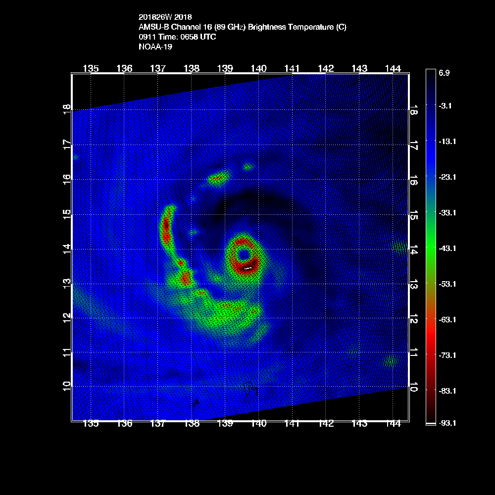

CIMSS/NESDIS-USAF/NRL AMSU TC Intensity Estimation:
SUPER TYPHOON 26W
Tuesday 11sep18 Time: 0658 UTC
Latitude: 14.00 Longitude: 139.46
Storm position corresponds to AMSU-A FOV 22 [1<--->30]
-----------------------------------------------------------------
| Estimated MSLP: 903 hPa
| Estimated Maximum Sustained Wind: 170 kts
| Estimate Confidence: Good ( +/- 10mb +/- 12kts )
-----------------------------------------------------------------
Storm is sub-sampled: Bias correction applied is -23.0 hPa
Channel 8 (~150 hPa) Tb Anomaly: 5.45795
Channel 7 (~250 hPa) Tb Anomaly: 5.77
RMW: 18 km
RMW Source is: MW
Environmental Pressure: 1006
Satellite: NOAA-19
ATCF data for Month: 09 Day: 11 Time (UTC): 0600
For imagery, go to http://amsu.ssec.wisc.edu
For all comments and questions mailto:chrisv@ssec.wisc.edu
2 likes
Contract Meteorologist. TAMU & MSST. Fiercely authentic, one of a kind. We are all given free will, so choose a life meant to be lived. We are the Masters of our own Stories.
Opinions expressed are mine alone.
Follow me on Twitter at @1900hurricane : Read blogs at https://1900hurricane.wordpress.com/
Opinions expressed are mine alone.
Follow me on Twitter at @1900hurricane : Read blogs at https://1900hurricane.wordpress.com/
Who is online
Users browsing this forum: No registered users and 145 guests