ATL: FLORENCE - Models

Moderator: S2k Moderators
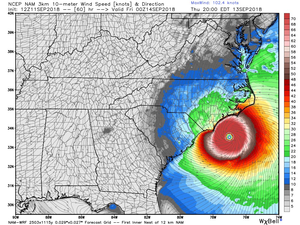
Message
Author
tolakram
Admin
Admin
Posts: 20009
Age: 62
Joined: Sun Aug 27, 2006 8:23 pm
Location: Florence, KY (name is Mark)

Re: ATL: FLORENCE - Models

#3441 Postby tolakram » Tue Sep 11, 2018 9:35 am

Model plots. Keep in mind this shows a bunch of models regardless of skill. All models are NOT equal.

Image

Image

Source: https://www.sfwmd.gov/weather-radar/hurricane-model-plots
1 likes   
M a r k
- - - - -
Join us in chat: Storm2K Chatroom Invite. Android and IOS apps also available.

The posts in this forum are NOT official forecasts and should not be used as such. Posts are NOT endorsed by any professional institution or STORM2K.org. For official information and forecasts, please refer to NHC and NWS products.

dspguy
Tropical Depression
Tropical Depression
Posts: 61
Joined: Wed Sep 06, 2017 2:26 pm
Location: Charleston, SC

Re: ATL: FLORENCE - Models

#3442 Postby dspguy » Tue Sep 11, 2018 9:51 am

Dean4Storms wrote:
dspguy wrote:Model question:

What's the difference between the MSLP & 10m Wind model and the MSLP & 850hpa Wind model? I get that one is showing wind speed near the surface? And the other... the wind speed at cloud level?


Basically you got that correct.

Ok, so if there's 90mph winds many thousands of feet up but only 30mph winds hitting the trees nearby, should I be concerned about 90mph thousands of feet up?
0 likes   

User avatar
AJC3
Admin
Admin
Posts: 3999
Age: 61
Joined: Tue Aug 31, 2004 7:04 pm
Location: Ballston Spa, New York
Contact:

Re: ATL: FLORENCE - Models

#3443 Postby AJC3 » Tue Sep 11, 2018 9:57 am

dspguy wrote:
Dean4Storms wrote:
dspguy wrote:Model question:

What's the difference between the MSLP & 10m Wind model and the MSLP & 850hpa Wind model? I get that one is showing wind speed near the surface? And the other... the wind speed at cloud level?


Basically you got that correct.

Ok, so if there's 90mph winds many thousands of feet up but only 30mph winds hitting the trees nearby, should I be concerned about 90mph thousands of feet up?


The answer to that would be "a little", since sustained 30 MPH winds usually gust to around 50 MPH or so, which can cause some minor damage.

However, your hypothetical example isn't how TC winds work - 90 MPH flight level (either 5KFT or 10KFT) winds around a TC will translate into much stronger surface winds than 30 MPH.
5 likes   

edu2703
Category 1
Category 1
Posts: 349
Joined: Thu Aug 23, 2018 7:15 pm

Re: ATL: FLORENCE - Models

#3444 Postby edu2703 » Tue Sep 11, 2018 10:32 am

12z NAM

Image
0 likes   

User avatar
Bocadude85
Category 5
Category 5
Posts: 2991
Age: 38
Joined: Mon Apr 18, 2005 2:20 pm
Location: Honolulu,Hi

Re: ATL: FLORENCE - Models

#3445 Postby Bocadude85 » Tue Sep 11, 2018 10:48 am

The 12Z GFS is quite a bit southwest of the 6z at 54 hours

[url]Image[/url]
0 likes   

User avatar
chris_fit
Category 5
Category 5
Posts: 3222
Age: 42
Joined: Wed Sep 10, 2003 11:58 pm
Location: Tampa Bay Area, FL

Re: ATL: FLORENCE - Models

#3446 Postby chris_fit » Tue Sep 11, 2018 10:48 am

12 GFS is coming in a good ways SOUTH. I hope people in SC are watching this VERY VERY closely...

Image
0 likes   

edu2703
Category 1
Category 1
Posts: 349
Joined: Thu Aug 23, 2018 7:15 pm

Re: ATL: FLORENCE - Models

#3447 Postby edu2703 » Tue Sep 11, 2018 10:48 am

12z GFS trending southwest. Looks like we will have a model consensus
0 likes   

User avatar
KWT
Category 5
Category 5
Posts: 31415
Joined: Tue Aug 17, 2004 11:02 am
Location: UK!!!

Re: ATL: FLORENCE - Models

#3448 Postby KWT » Tue Sep 11, 2018 10:50 am

Well its taken many days and dozens of runs...

BUT FINALLY...the GFS has given in and shifted SW towards the other models. Its just offshore at 60hrs and rapidly slowing down, looks like a hit for S. NC.

Hope the person who has been on this thread who was supporting the GFS/other OTS runs has prepared and listened to the NHC, who have done just an outstanding job with this one.
Last edited by KWT on Tue Sep 11, 2018 10:50 am, edited 1 time in total.
3 likes   
Personal Forecast Disclaimer:
The posts in this forum are NOT official forecast and should not be used as such. They are just the opinion of the poster and may or may not be backed by sound meteorological data. They are NOT endorsed by any professional institution or storm2k.org. For official information, please refer to the NHC and NWS products

tallywx
Category 2
Category 2
Posts: 790
Joined: Thu Jul 03, 2003 10:19 am
Location: Raleigh/Durham, NC

Re: ATL: FLORENCE - Models

#3449 Postby tallywx » Tue Sep 11, 2018 10:50 am

The GFS caved. Wow.

This is what happens when you start being able to sample the upper air pattern for systems coming ashore in the Pacific Northwest. I almost think one should do sampling flights over there since it’s those systems that define all the ridges and troughs downstream.
Last edited by tallywx on Tue Sep 11, 2018 10:52 am, edited 1 time in total.
0 likes   

User avatar
KWT
Category 5
Category 5
Posts: 31415
Joined: Tue Aug 17, 2004 11:02 am
Location: UK!!!

Re: ATL: FLORENCE - Models

#3450 Postby KWT » Tue Sep 11, 2018 10:52 am

tallywx wrote:The GFS caved. Wow.


As some of us very old hands have been telling people, the GFS has got some serious right side bias. That combined with occasionally unrealistic pressures combines to ensure the GFS can be a poor model in set-ups with strong upper ridging.

Interesting the FV3 has been almost as outstanding as the ECMWF/NHC have been, which is surely a good sign for the future.
6 likes   
Personal Forecast Disclaimer:
The posts in this forum are NOT official forecast and should not be used as such. They are just the opinion of the poster and may or may not be backed by sound meteorological data. They are NOT endorsed by any professional institution or storm2k.org. For official information, please refer to the NHC and NWS products

jlauderdal
S2K Supporter
S2K Supporter
Posts: 7183
Joined: Wed May 19, 2004 5:46 am
Location: NE Fort Lauderdale
Contact:

Re: RE: Re: ATL: FLORENCE - Models

#3451 Postby jlauderdal » Tue Sep 11, 2018 10:52 am

tallywx wrote:The GFS caved. Wow.
No surprise here, several of us have been saying since Saturday it is biased to the right, it could still be correct but we are getting close to the point of no return
0 likes   

supercane4867
Category 5
Category 5
Posts: 4966
Joined: Wed Nov 14, 2012 10:43 am

Re: ATL: FLORENCE - Models

#3452 Postby supercane4867 » Tue Sep 11, 2018 10:56 am

12z GFS has CAT4 landfall near Cape Fear and stalls just inland.
0 likes   

Vdogg
Category 2
Category 2
Posts: 621
Joined: Wed Aug 31, 2016 9:56 am

Re: ATL: FLORENCE - Models

#3453 Postby Vdogg » Tue Sep 11, 2018 10:57 am

CMC went way North with an OBX hit. GFS went way south with an NC/SC border hit. GFS is now south of the Euro and FV3.
0 likes   

User avatar
Bocadude85
Category 5
Category 5
Posts: 2991
Age: 38
Joined: Mon Apr 18, 2005 2:20 pm
Location: Honolulu,Hi

Re: ATL: FLORENCE - Models

#3454 Postby Bocadude85 » Tue Sep 11, 2018 10:59 am

Looking at the 0Z ECMWF ensembles I would not be surprised if Florence landfalls somewhere between Charleston and Myrtle Beach, just my opinion of course.
0 likes   

User avatar
Bocadude85
Category 5
Category 5
Posts: 2991
Age: 38
Joined: Mon Apr 18, 2005 2:20 pm
Location: Honolulu,Hi

Re: ATL: FLORENCE - Models

#3455 Postby Bocadude85 » Tue Sep 11, 2018 11:05 am

Vdogg wrote:CMC went way North with an OBX hit. GFS went way south with an NC/SC border hit. GFS is now south of the Euro and FV3.


The 12z CMC is west of the 0z run by a decent amount, no real change in latitude though.
0 likes   

crimi481
Category 2
Category 2
Posts: 602
Joined: Thu Sep 09, 2004 4:47 pm

Re: ATL: FLORENCE - Models

#3456 Postby crimi481 » Tue Sep 11, 2018 11:06 am

Do the models consider the low pressure in the gulf? Would Flo be drawn more sw to low pressure - as it will be blocked from north by ridge?
0 likes   

User avatar
Blinhart
Category 5
Category 5
Posts: 2081
Age: 48
Joined: Thu Sep 08, 2011 3:13 pm
Location: Crowley, La.

Re: ATL: FLORENCE - Models

#3457 Postby Blinhart » Tue Sep 11, 2018 11:10 am

1 likes   
Personal Forecast Disclaimer:
The posts in this forum are NOT official forecast and should not be used as such. They are just the opinion of the poster and may or may not be backed by sound meteorological data. They are NOT endorsed by any professional institution or storm2k.org. For official information, please refer to the NHC and NWS products.

User avatar
MGC
S2K Supporter
S2K Supporter
Posts: 5899
Joined: Sun Mar 23, 2003 9:05 pm
Location: Pass Christian MS, or what is left.

Re: ATL: FLORENCE - Models

#3458 Postby MGC » Tue Sep 11, 2018 11:20 am

12Z GFS is much more believable. No crazy cat-5 loops off Hatteras....MGC
1 likes   

tolakram
Admin
Admin
Posts: 20009
Age: 62
Joined: Sun Aug 27, 2006 8:23 pm
Location: Florence, KY (name is Mark)

Re: ATL: FLORENCE - Models

#3459 Postby tolakram » Tue Sep 11, 2018 11:22 am

12Z GFS
Image
0 likes   
M a r k
- - - - -
Join us in chat: Storm2K Chatroom Invite. Android and IOS apps also available.

The posts in this forum are NOT official forecasts and should not be used as such. Posts are NOT endorsed by any professional institution or STORM2K.org. For official information and forecasts, please refer to NHC and NWS products.

User avatar
pgoss11
Category 2
Category 2
Posts: 702
Joined: Tue Sep 02, 2003 3:55 pm

Re: ATL: FLORENCE - Models

#3460 Postby pgoss11 » Tue Sep 11, 2018 11:23 am

Bocadude85 wrote:Looking at the 0Z ECMWF ensembles I would not be surprised if Florence landfalls somewhere between Charleston and Myrtle Beach, just my opinion of course.

I was really surprised to see the 0Z ECMWF ensembles. I wouldn't be surprised to see landfall closer to Myrtle Beach.
0 likes   


Return to “2018”

Who is online

Users browsing this forum: No registered users and 2 guests