WPAC: MANGKHUT - Post-Tropical
Moderator: S2k Moderators

Re: WPAC: MANGKHUT - Typhoon
0 likes
Very useful information on the Dvorak Technique --
https://severe.worldweather.wmo.int/TCF ... kBeven.pdf
https://severe.worldweather.wmo.int/TCF ... kBeven.pdf
Re: WPAC: MANGKHUT - Typhoon
euro6208 wrote:
Only gets warmer along the track...

hour 72 looks gucci
0 likes
Very useful information on the Dvorak Technique --
https://severe.worldweather.wmo.int/TCF ... kBeven.pdf
https://severe.worldweather.wmo.int/TCF ... kBeven.pdf


Re: WPAC: MANGKHUT - Typhoon
Very tight agreement in the forecast track

2 likes
Personal Forecast Disclaimer:
The posts in this forum are NOT official forecast and should not be used as such. They are just the opinion of the poster and may or may not be backed by sound meteorological data. They are NOT endorsed by any professional institution or storm2k.org. For official information, please refer to RSMC and NWS products.
The posts in this forum are NOT official forecast and should not be used as such. They are just the opinion of the poster and may or may not be backed by sound meteorological data. They are NOT endorsed by any professional institution or storm2k.org. For official information, please refer to RSMC and NWS products.
Re: WPAC: MANGKHUT - Typhoon
So this is about the target intensity we are looking for around hour 72 if things go according to Hoyle, I'd say.
0 likes
Very useful information on the Dvorak Technique --
https://severe.worldweather.wmo.int/TCF ... kBeven.pdf
https://severe.worldweather.wmo.int/TCF ... kBeven.pdf
-
supercane4867
- Category 5

- Posts: 4966
- Joined: Wed Nov 14, 2012 10:43 am
Re: WPAC: MANGKHUT - Typhoon
If the current forecast track holds, Mangkut would be the strongest storm on record to impact the Pearl river delta region and damage could well exceed 10 billion dollars
0 likes
-
supercane4867
- Category 5
- Posts: 4966
- Joined: Wed Nov 14, 2012 10:43 am


-
mrbagyo

- Category 5
- Posts: 3963
- Age: 33
- Joined: Thu Apr 12, 2012 9:18 am
- Location: 14.13N 120.98E
- Contact:
Re: WPAC: MANGKHUT - Typhoon
Sta Ana, Cagayan looks intriguing.
I went there during Typhoon Haima last Oct 2016 (it's my regret that I didn't follow James southward to Tuguegarao - winds at Sta Ana maybe topped at Cat 1 force only).
Maybe the typhoon gods wanna give me a second chance. Heh. I'll try to apply a vacation leave for Friday.

I went there during Typhoon Haima last Oct 2016 (it's my regret that I didn't follow James southward to Tuguegarao - winds at Sta Ana maybe topped at Cat 1 force only).
Maybe the typhoon gods wanna give me a second chance. Heh. I'll try to apply a vacation leave for Friday.
0 likes
The posts in this forum are NOT official forecast and should not be used as such. They are just the opinion of the poster and may or may not be backed by sound meteorological data. They are NOT endorsed by any professional institution or storm2k.org. For official information, please refer to RSMC, NHC and NWS products.
Re: WPAC: MANGKHUT - Typhoon
The last time when media in Hong Kong and HKO were so concerned about a typhoon seems to be Usagi'13. Let's see if the city is really well-prepared for such a typhoon if the forecast track verifies.
0 likes
Personal Forecast Disclaimer:
The posts in this forum are NOT official forecast and should not be used as such. They are just the opinion of the poster and may or may not be backed by sound meteorological data. They are NOT endorsed by any professional institution or storm2k.org. For official information, please refer to RSMC and NWS products.
The posts in this forum are NOT official forecast and should not be used as such. They are just the opinion of the poster and may or may not be backed by sound meteorological data. They are NOT endorsed by any professional institution or storm2k.org. For official information, please refer to RSMC and NWS products.
-
1900hurricane

- Category 5
- Posts: 6063
- Age: 34
- Joined: Fri Feb 06, 2015 12:04 pm
- Location: Houston, TX
- Contact:
Re: WPAC: MANGKHUT - Typhoon
Very powerful eyewall now on the latest GPM pass. Also maybe some early hints of a developing outer eyewall on 37 GHz.


0 likes
Contract Meteorologist. TAMU & MSST. Fiercely authentic, one of a kind. We are all given free will, so choose a life meant to be lived. We are the Masters of our own Stories.
Opinions expressed are mine alone.
Follow me on Twitter at @1900hurricane : Read blogs at https://1900hurricane.wordpress.com/
Opinions expressed are mine alone.
Follow me on Twitter at @1900hurricane : Read blogs at https://1900hurricane.wordpress.com/
-
mrbagyo
- Category 5
- Posts: 3963
- Age: 33
- Joined: Thu Apr 12, 2012 9:18 am
- Location: 14.13N 120.98E
- Contact:
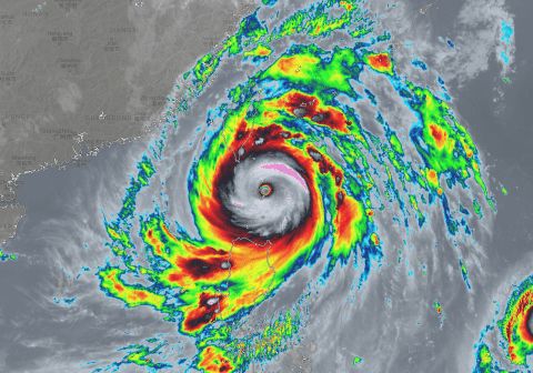
Re: WPAC: MANGKHUT - Typhoon
+20.60°C
wow.
JMA 15z
105 knots
915 mb
wow.
JMA 15z
105 knots
915 mb
0 likes
The posts in this forum are NOT official forecast and should not be used as such. They are just the opinion of the poster and may or may not be backed by sound meteorological data. They are NOT endorsed by any professional institution or storm2k.org. For official information, please refer to RSMC, NHC and NWS products.
Re: WPAC: MANGKHUT - Typhoon

Eye looks even warmer now.
0 likes
Very useful information on the Dvorak Technique --
https://severe.worldweather.wmo.int/TCF ... kBeven.pdf
https://severe.worldweather.wmo.int/TCF ... kBeven.pdf
Re: WPAC: MANGKHUT - Typhoon
SATCON estimate is fluctuating and down to 145KT for the time being. Maybe the earlier estimates were distorted by erroneous RMW estimate. Personally I would go with 150KT at 18Z.
0 likes
Personal Forecast Disclaimer:
The posts in this forum are NOT official forecast and should not be used as such. They are just the opinion of the poster and may or may not be backed by sound meteorological data. They are NOT endorsed by any professional institution or storm2k.org. For official information, please refer to RSMC and NWS products.
The posts in this forum are NOT official forecast and should not be used as such. They are just the opinion of the poster and may or may not be backed by sound meteorological data. They are NOT endorsed by any professional institution or storm2k.org. For official information, please refer to RSMC and NWS products.
-
1900hurricane
- Category 5
- Posts: 6063
- Age: 34
- Joined: Fri Feb 06, 2015 12:04 pm
- Location: Houston, TX
- Contact:
Re: WPAC: MANGKHUT - Typhoon
JTWC remains at 140 kt for 18Z.
0 likes
Contract Meteorologist. TAMU & MSST. Fiercely authentic, one of a kind. We are all given free will, so choose a life meant to be lived. We are the Masters of our own Stories.
Opinions expressed are mine alone.
Follow me on Twitter at @1900hurricane : Read blogs at https://1900hurricane.wordpress.com/
Opinions expressed are mine alone.
Follow me on Twitter at @1900hurricane : Read blogs at https://1900hurricane.wordpress.com/
Re: WPAC: MANGKHUT - Typhoon
Reminds me of VongFong 2014
2 likes
Very useful information on the Dvorak Technique --
https://severe.worldweather.wmo.int/TCF ... kBeven.pdf
https://severe.worldweather.wmo.int/TCF ... kBeven.pdf
-
mrbagyo
- Category 5
- Posts: 3963
- Age: 33
- Joined: Thu Apr 12, 2012 9:18 am
- Location: 14.13N 120.98E
- Contact:
Re: WPAC: MANGKHUT - Typhoon

Goodness gracious, eye temp is now hovering within the range of 20.5 to 21.7 and this may still get warmer as it enters the warmest area of Philippine Sea (barring any internal issues)
0 likes
The posts in this forum are NOT official forecast and should not be used as such. They are just the opinion of the poster and may or may not be backed by sound meteorological data. They are NOT endorsed by any professional institution or storm2k.org. For official information, please refer to RSMC, NHC and NWS products.
Re: WPAC: MANGKHUT - Typhoon
mrbagyo wrote:https://imageshack.com/a/img923/4470/ZO97jq.gif
Goodness gracious, eye temp is now hovering within the range of 20.5 to 21.7 and this may still get warmer as it enters the warmest area of Philippine Sea (barring any internal issues)

The eye is torched. Good call by the JMA to bring the pressure down to 905 mb.
0 likes
Very useful information on the Dvorak Technique --
https://severe.worldweather.wmo.int/TCF ... kBeven.pdf
https://severe.worldweather.wmo.int/TCF ... kBeven.pdf
-
mrbagyo
- Category 5
- Posts: 3963
- Age: 33
- Joined: Thu Apr 12, 2012 9:18 am
- Location: 14.13N 120.98E
- Contact:
Re: WPAC: MANGKHUT - Typhoon
Highteeld wrote:mrbagyo wrote:https://imageshack.com/a/img923/4470/ZO97jq.gif
Goodness gracious, eye temp is now hovering within the range of 20.5 to 21.7 and this may still get warmer as it enters the warmest area of Philippine Sea (barring any internal issues)
The eye is torched. Good call by the JMA to bring the pressure down to 905 mb.
That presentation is insane.
Updated EPS trend
https://imageshack.com/a/img921/518/phy40U.gif
0 likes
The posts in this forum are NOT official forecast and should not be used as such. They are just the opinion of the poster and may or may not be backed by sound meteorological data. They are NOT endorsed by any professional institution or storm2k.org. For official information, please refer to RSMC, NHC and NWS products.
Who is online
Users browsing this forum: No registered users and 136 guests