ATL: FLORENCE - Models

Moderator: S2k Moderators

Message
Author
Raebie
Category 3
Category 3
Posts: 822
Joined: Fri Sep 12, 2003 8:00 pm
Location: Charlotte, NC

Re: RE: Re: ATL: FLORENCE - Models

#3641 Postby Raebie » Tue Sep 11, 2018 5:34 pm

jlauderdal wrote:
Raebie wrote:If the ridge is so strong that it causes that SW dive, how does she get so far north in the first place??
Ridges come and go like troughs, fluid dynamics, constant motion which is so complex that the models struggle


Makes sense. They've been sampling the ridge today so I'm gonna wait for that data to make it into the models. Hopefully they'll get a handle on it. It seems that they aren't there yet.
0 likes   

SunnyThoughts
Category 5
Category 5
Posts: 2263
Joined: Wed Jul 09, 2003 12:42 pm
Location: Pensacola, Florida

Re: ATL: FLORENCE - Models

#3642 Postby SunnyThoughts » Tue Sep 11, 2018 5:34 pm

Aric stated earlier that Gonzo was sampling the upper atmosphere along the Carolinas concerning the ridge etc...Perhaps that will help in the next suite of models. We may be looking at an entire different situation then. But who knows. I don't envy the NHC at all, and considering all these other storms and invests they are having to deal with at the same time. I cant even
1 likes   

User avatar
robbielyn
Category 5
Category 5
Posts: 1298
Joined: Wed May 07, 2003 9:45 am
Location: brooksville, fl

Re: ATL: FLORENCE - Models

#3643 Postby robbielyn » Tue Sep 11, 2018 5:35 pm

Raebie wrote:If the ridge is so strong that it causes that SW dive, how does she get so far north in the first place??

i’m. guessing as she moves into the ridge the ridge pushes her sw as it gets stronger moving south
1 likes   
Robbielyn McCrary
I know just about enough to sound like I know what I'm talking about sometimes. But for your safety please follow the nhc for truly professional forecasting. :D

MrStormX
Tropical Depression
Tropical Depression
Posts: 97
Joined: Thu Mar 10, 2011 9:48 pm

Re: ATL: FLORENCE - Models

#3644 Postby MrStormX » Tue Sep 11, 2018 5:35 pm

I suspect that Invest 95L is also having an impact on the model runs.
0 likes   

Raebie
Category 3
Category 3
Posts: 822
Joined: Fri Sep 12, 2003 8:00 pm
Location: Charlotte, NC

Re: ATL: FLORENCE - Models

#3645 Postby Raebie » Tue Sep 11, 2018 5:36 pm

SunnyThoughts wrote:Aric stated earlier that Gonzo was sampling the upper atmosphere along the Carolinas concerning the ridge etc...Perhaps that will help in the next suite of models. We may be looking at an entire different situation then. But who knows. I don't envy the NHC at all, and considering all these other storms and invests they are having to deal with at the same time. I cant even


WELL MY STORM IS THE MOST IMPORTANT!!
:D
9 likes   

tolakram
Admin
Admin
Posts: 20009
Age: 62
Joined: Sun Aug 27, 2006 8:23 pm
Location: Florence, KY (name is Mark)

Re: ATL: FLORENCE - Models

#3646 Postby tolakram » Tue Sep 11, 2018 5:40 pm

18Z GFS
Image
0 likes   
M a r k
- - - - -
Join us in chat: Storm2K Chatroom Invite. Android and IOS apps also available.

The posts in this forum are NOT official forecasts and should not be used as such. Posts are NOT endorsed by any professional institution or STORM2K.org. For official information and forecasts, please refer to NHC and NWS products.

Ken711
Category 5
Category 5
Posts: 1074
Joined: Tue Aug 28, 2012 12:48 pm

Re: ATL: FLORENCE - Models

#3647 Postby Ken711 » Tue Sep 11, 2018 5:40 pm

Raebie wrote:If the ridge is so strong that it causes that SW dive, how does she get so far north in the first place??


The orientation of the ridge perhaps.
0 likes   

Aric Dunn
Category 5
Category 5
Posts: 21238
Age: 42
Joined: Sun Sep 19, 2004 9:58 pm
Location: Ready for the Chase.
Contact:

Re: ATL: FLORENCE - Models

#3648 Postby Aric Dunn » Tue Sep 11, 2018 5:45 pm

the gfs is a little faster with the sw movement. keeps it stronger throughout.
0 likes   
Note: If I make a post that is brief. Please refer back to previous posts for the analysis or reasoning. I do not re-write/qoute what my initial post said each time.
If there is nothing before... then just ask :)

Space & Atmospheric Physicist, Embry-Riddle Aeronautical University,
I believe the sky is falling...

User avatar
Blinhart
Category 5
Category 5
Posts: 2079
Age: 48
Joined: Thu Sep 08, 2011 3:13 pm
Location: Crowley, La.

Re: ATL: FLORENCE - Models

#3649 Postby Blinhart » Tue Sep 11, 2018 5:46 pm

tolakram wrote:18Z GFS
https://i.imgur.com/J8AHOKx.gif


At the end is that her coming back for an encore????
2 likes   
Personal Forecast Disclaimer:
The posts in this forum are NOT official forecast and should not be used as such. They are just the opinion of the poster and may or may not be backed by sound meteorological data. They are NOT endorsed by any professional institution or storm2k.org. For official information, please refer to the NHC and NWS products.

User avatar
Fishing
S2K Supporter
S2K Supporter
Posts: 67
Age: 65
Joined: Thu Sep 03, 2015 11:53 am
Location: Mount Pleasant, SC

Re: ATL: FLORENCE - Models

#3650 Postby Fishing » Tue Sep 11, 2018 5:51 pm

Aric Dunn wrote:the gfs is a little faster with the sw movement. keeps it stronger throughout.


What are we looking at if it landfalls in Charleston? We are here and stayed for Hugo. Definitely do not want to do that again.
0 likes   

catskillfire51
S2K Supporter
S2K Supporter
Posts: 480
Age: 38
Joined: Sun Aug 26, 2012 5:40 pm
Location: Lake Jackson, TX

Re: ATL: FLORENCE - Models

#3651 Postby catskillfire51 » Tue Sep 11, 2018 5:51 pm

Blinhart wrote:
tolakram wrote:18Z GFS
https://i.imgur.com/J8AHOKx.gif


At the end is that her coming back for an encore????


Sure looks like it, it's off GA at 300Hr
0 likes   

catskillfire51
S2K Supporter
S2K Supporter
Posts: 480
Age: 38
Joined: Sun Aug 26, 2012 5:40 pm
Location: Lake Jackson, TX

Re: ATL: FLORENCE - Models

#3652 Postby catskillfire51 » Tue Sep 11, 2018 5:52 pm

Another landfall at Fl/Ga line
1 likes   

PandaCitrus
Category 1
Category 1
Posts: 424
Joined: Mon Sep 04, 2017 2:44 pm

Re: ATL: FLORENCE - Models

#3653 Postby PandaCitrus » Tue Sep 11, 2018 5:53 pm

The Euro Ensembles show many Cat 1 and Cat 2 members during the stall phase. It could go like Hurricane Diana and Florence could weaken to a Cat 1/2 before an eventual landfall because of increased land interaction, shear, dry air, and upwelling while she sits and spins for hours and hours.

If the core of the storm is far enough away, the north carolina coast may luck out with similar effects to what Florida received with Hurricane Matthew. Some Cat 1 conditions, flooding, beach erosion but no catastrophic damage.

It could be a lot worse honestly. I think this is preferable to a Cat 3/4 barrelling in like Hugo. Also the coastal scraper avoids the inland flood catastrophe.
0 likes   

Aric Dunn
Category 5
Category 5
Posts: 21238
Age: 42
Joined: Sun Sep 19, 2004 9:58 pm
Location: Ready for the Chase.
Contact:

Re: ATL: FLORENCE - Models

#3654 Postby Aric Dunn » Tue Sep 11, 2018 5:56 pm

Fishing wrote:
Aric Dunn wrote:the gfs is a little faster with the sw movement. keeps it stronger throughout.


What are we looking at if it landfalls in Charleston? We are here and stayed for Hugo. Definitely do not want to do that again.


very hard to say. model consensus is the best we go with right now. NHC will be in top ofit :)
1 likes   
Note: If I make a post that is brief. Please refer back to previous posts for the analysis or reasoning. I do not re-write/qoute what my initial post said each time.
If there is nothing before... then just ask :)

Space & Atmospheric Physicist, Embry-Riddle Aeronautical University,
I believe the sky is falling...

User avatar
HurricaneBelle
S2K Supporter
S2K Supporter
Posts: 1179
Joined: Sun Aug 27, 2006 6:12 pm
Location: Clearwater, FL

Re: ATL: FLORENCE - Models

#3655 Postby HurricaneBelle » Tue Sep 11, 2018 5:57 pm

catskillfire51 wrote:Another landfall at Fl/Ga line


Reminiscent of the Matthew GFS runs a couple of years ago where he moved off NC and then whipped around back to hit SFL.

EDIT: After watching the run a bit more closely, it's looks like Flo's remnants move into NY/New England but there's a trailing trough from them and what hits FL/GA is something new that forms from the tail end of the trough.
Last edited by HurricaneBelle on Tue Sep 11, 2018 6:00 pm, edited 1 time in total.
0 likes   

tolakram
Admin
Admin
Posts: 20009
Age: 62
Joined: Sun Aug 27, 2006 8:23 pm
Location: Florence, KY (name is Mark)

Re: ATL: FLORENCE - Models

#3656 Postby tolakram » Tue Sep 11, 2018 5:58 pm

I didn't intend to save that much of the loop. Something to completely ignore IMO, too far out and these post landfall loops rarely amount to anything.
4 likes   
M a r k
- - - - -
Join us in chat: Storm2K Chatroom Invite. Android and IOS apps also available.

The posts in this forum are NOT official forecasts and should not be used as such. Posts are NOT endorsed by any professional institution or STORM2K.org. For official information and forecasts, please refer to NHC and NWS products.

Ken711
Category 5
Category 5
Posts: 1074
Joined: Tue Aug 28, 2012 12:48 pm

Re: RE: Re: ATL: FLORENCE - Models

#3657 Postby Ken711 » Tue Sep 11, 2018 5:58 pm

Raebie wrote:
jlauderdal wrote:
Raebie wrote:If the ridge is so strong that it causes that SW dive, how does she get so far north in the first place??
Ridges come and go like troughs, fluid dynamics, constant motion which is so complex that the models struggle


Makes sense. They've been sampling the ridge today so I'm gonna wait for that data to make it into the models. Hopefully they'll get a handle on it. It seems that they aren't there yet.


Levi Cowan has a good explanation.

https://www.youtube.com/watch?v=wml6hafjrUQ
1 likes   

User avatar
Blinhart
Category 5
Category 5
Posts: 2079
Age: 48
Joined: Thu Sep 08, 2011 3:13 pm
Location: Crowley, La.

Re: ATL: FLORENCE - Models

#3658 Postby Blinhart » Tue Sep 11, 2018 5:59 pm

So only one shows it getting to Cat 5 now, but that can still change.

https://www.tropicaltidbits.com/stormin ... latest.png
0 likes   
Personal Forecast Disclaimer:
The posts in this forum are NOT official forecast and should not be used as such. They are just the opinion of the poster and may or may not be backed by sound meteorological data. They are NOT endorsed by any professional institution or storm2k.org. For official information, please refer to the NHC and NWS products.

User avatar
SouthFLTropics
Category 5
Category 5
Posts: 4236
Age: 50
Joined: Thu Aug 14, 2003 8:04 am
Location: Port St. Lucie, Florida

Re: ATL: FLORENCE - Models

#3659 Postby SouthFLTropics » Tue Sep 11, 2018 6:02 pm

Ok...that run of the 18z GFS was hands down the craziest complete run I think I've ever watched. Later in the period it spins off another storm or is that Florence again coming back and hitting FL/GA line and then diving SE into the Bahamas and developing??? What in the world??? :double:
2 likes   
Fourth Generation Florida Native

Personal Storm History: David 79, Andrew 92, Erin 95, Floyd 99, Irene 99, Frances 04, Jeanne 04, Wilma 05, Matthew 16, Irma 17, Ian 22, Nicole 22, Milton 24

supercane4867
Category 5
Category 5
Posts: 4966
Joined: Wed Nov 14, 2012 10:43 am

Re: ATL: FLORENCE - Models

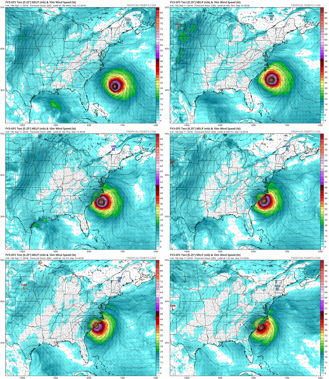
#3660 Postby supercane4867 » Tue Sep 11, 2018 6:03 pm

18z FV3 GFS still has a initial landfall near Wilmington

Image
0 likes   


Return to “2018”

Who is online

Users browsing this forum: No registered users and 0 guests