ATL: FLORENCE - Models

Moderator: S2k Moderators

Message
Author
GTStorm
Tropical Storm
Tropical Storm
Posts: 225
Joined: Sat Sep 04, 2004 8:44 pm
Location: Savannah

Re: ATL: FLORENCE - Models

#3681 Postby GTStorm » Tue Sep 11, 2018 8:24 pm

crimi481 wrote:Would you say this is a model trend? s.w


maybe, but hard to believe this is sustainable. Seems like the complex ridging set-up the models are picking up on is just not normal.

Question for the pros...is this abnormal...or just unfortunate timing? Or both?
1 likes   

User avatar
Bocadude85
Category 5
Category 5
Posts: 2991
Age: 38
Joined: Mon Apr 18, 2005 2:20 pm
Location: Honolulu,Hi

Re: ATL: FLORENCE - Models

#3682 Postby Bocadude85 » Tue Sep 11, 2018 8:24 pm

Blown Away wrote:TVCN (Grey Line) buying into the SW movement just offshore...


The 0z models are going to be very interesting, if the stall happens any further offshore then Georgia could be in trouble.
0 likes   

Aric Dunn
Category 5
Category 5
Posts: 21238
Age: 42
Joined: Sun Sep 19, 2004 9:58 pm
Location: Ready for the Chase.
Contact:

Re: ATL: FLORENCE - Models

#3683 Postby Aric Dunn » Tue Sep 11, 2018 8:27 pm

early guidance/bams shift west again..
0 likes   
Note: If I make a post that is brief. Please refer back to previous posts for the analysis or reasoning. I do not re-write/qoute what my initial post said each time.
If there is nothing before... then just ask :)

Space & Atmospheric Physicist, Embry-Riddle Aeronautical University,
I believe the sky is falling...

User avatar
sponger
S2K Supporter
S2K Supporter
Posts: 1620
Joined: Thu Jul 22, 2004 11:26 am
Location: St Augustine

Re: ATL: FLORENCE - Models

#3684 Postby sponger » Tue Sep 11, 2018 8:29 pm

Aric Dunn wrote:early guidance/bams shift west again..


I honestly thought SC was being overly cautious two days ago, especially the southern half of the state.
3 likes   
The following post is NOT an official forecast and should not be used as such. It is just the opinion of the poster and may or may not be backed by sound meteorological data. It is NOT endorsed by any professional institution including storm2k.org For Official Information please refer to the NHC and NWS products.

jlauderdal
S2K Supporter
S2K Supporter
Posts: 7182
Joined: Wed May 19, 2004 5:46 am
Location: NE Fort Lauderdale
Contact:

Re: RE: Re: ATL: FLORENCE - Models

#3685 Postby jlauderdal » Tue Sep 11, 2018 8:31 pm

Aric Dunn wrote:early guidance/bams shift west again..
Models been struggling with ridges for years...to be fair this is an extremely complex setup, savannah might find itself in the game
5 likes   

invest man
Tropical Storm
Tropical Storm
Posts: 206
Joined: Sun Aug 17, 2008 8:12 pm

Re: ATL: FLORENCE - Models

#3686 Postby invest man » Tue Sep 11, 2018 8:34 pm

NDG wrote:NHC will have but no option but to shift the track SW closer to the TVCN, GFS and Euro after day 2.5-5 day range.

https://i.imgur.com/gKFLBhx.gif

If any of those tracks other than the NHC actually takes place, that would be very bazaar! Last night models were looking like they were going to shift to OTS eventually! Can somebody tell me what has changed or is these models flipping because none of them have ever computed a set up like this and are not handling this well. I still think LF as Cat 3/4 between Emerald Isle and Wilmington then slowly west! IM
0 likes   

bonjourno
Tropical Depression
Tropical Depression
Posts: 69
Joined: Fri Aug 24, 2012 12:59 am
Location: Central Florida

Re: ATL: FLORENCE - Models

#3687 Postby bonjourno » Tue Sep 11, 2018 8:35 pm

Aric Dunn wrote:early guidance/bams shift west again..


What site can you go to see the BAM models? They're not on tropicaltidbits or COD.
1 likes   

Ken711
Category 5
Category 5
Posts: 1074
Joined: Tue Aug 28, 2012 12:48 pm

Re: ATL: FLORENCE - Models

#3688 Postby Ken711 » Tue Sep 11, 2018 8:36 pm

Aric Dunn wrote:early guidance/bams shift west again..


SC looks like NC did with this early guidance just a few days ago.
1 likes   

User avatar
NDG
S2K Supporter
S2K Supporter
Posts: 15446
Joined: Sun Jul 09, 2006 10:14 pm
Location: Orlando, FL

Re: ATL: FLORENCE - Models

#3689 Postby NDG » Tue Sep 11, 2018 8:37 pm

invest man wrote:
NDG wrote:NHC will have but no option but to shift the track SW closer to the TVCN, GFS and Euro after day 2.5-5 day range.

https://i.imgur.com/gKFLBhx.gif

If any of those tracks other than the NHC actually takes place, that would be very bazaar! Last night models were looking like they were going to shift to OTS eventually! Can somebody tell me what has changed or is these models flipping because none of them have ever computed a set up like this and are not handling this well. I still think LF as Cat 3/4 between Emerald Isle and Wilmington then slowly west! IM


Stronger ridge will be building to the north over the Great Lakes right before or around landfall making it hit the breaks and eventually track SW and wait for the ridge to keep moving eastward so that it go it goes poleward again.
0 likes   

User avatar
p1nheadlarry
Category 2
Category 2
Posts: 672
Age: 33
Joined: Wed Jan 29, 2014 2:42 pm
Location: SR County FL

Re: ATL: FLORENCE - Models

#3690 Postby p1nheadlarry » Tue Sep 11, 2018 8:40 pm

invest man wrote:
NDG wrote:NHC will have but no option but to shift the track SW closer to the TVCN, GFS and Euro after day 2.5-5 day range.

https://i.imgur.com/gKFLBhx.gif

If any of those tracks other than the NHC actually takes place, that would be very bazaar! Last night models were looking like they were going to shift to OTS eventually! Can somebody tell me what has changed or is these models flipping because none of them have ever computed a set up like this and are not handling this well. I still think LF as Cat 3/4 between Emerald Isle and Wilmington then slowly west! IM


Seems to be that the ridge building in from the plains/Great Lakes will be stronger than what is currently steering Florence. Maybe 95L is a player too in causing the continental ridge to strengthen.
1 likes   
--;->#GoNoles--;->.

User avatar
p1nheadlarry
Category 2
Category 2
Posts: 672
Age: 33
Joined: Wed Jan 29, 2014 2:42 pm
Location: SR County FL

Re: ATL: FLORENCE - Models

#3691 Postby p1nheadlarry » Tue Sep 11, 2018 8:41 pm

NDG wrote:
invest man wrote:
NDG wrote:NHC will have but no option but to shift the track SW closer to the TVCN, GFS and Euro after day 2.5-5 day range.

https://i.imgur.com/gKFLBhx.gif

If any of those tracks other than the NHC actually takes place, that would be very bazaar! Last night models were looking like they were going to shift to OTS eventually! Can somebody tell me what has changed or is these models flipping because none of them have ever computed a set up like this and are not handling this well. I still think LF as Cat 3/4 between Emerald Isle and Wilmington then slowly west! IM


Stronger ridge will be building to the north over the Great Lakes right before or around landfall making it hit the breaks and eventually track SW and wait for the ridge to keep moving eastward so that it go it goes poleward again.


Shoulda hit refresh before I posted :oops:
1 likes   
--;->#GoNoles--;->.

GTStorm
Tropical Storm
Tropical Storm
Posts: 225
Joined: Sat Sep 04, 2004 8:44 pm
Location: Savannah

Re: ATL: FLORENCE - Models

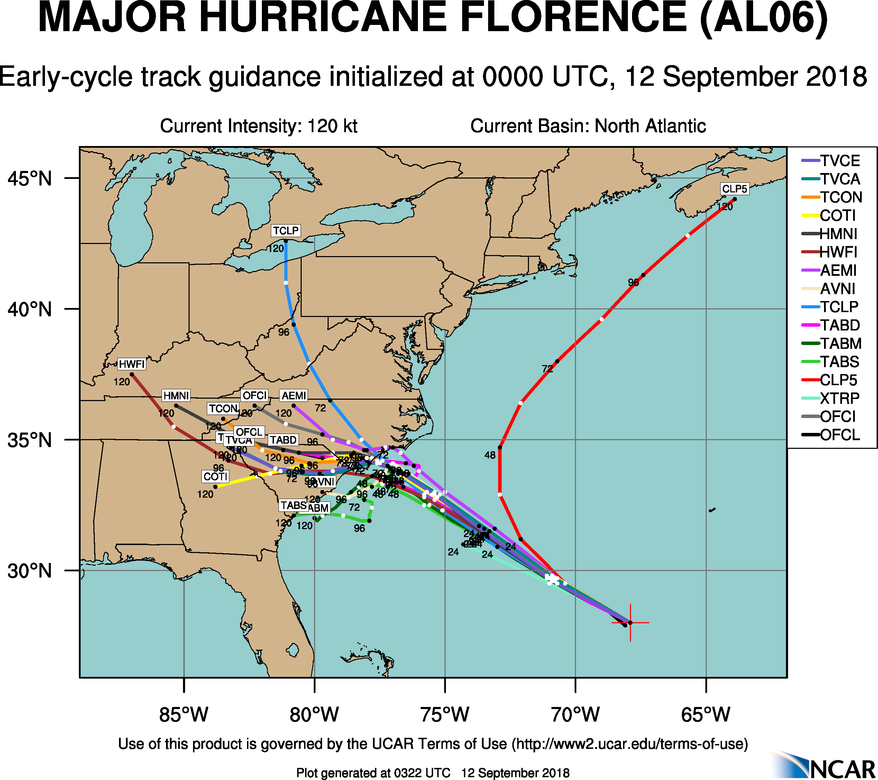
#3692 Postby GTStorm » Tue Sep 11, 2018 8:46 pm

Image

More early guidance (0Z)
0 likes   

User avatar
Blinhart
Category 5
Category 5
Posts: 2079
Age: 48
Joined: Thu Sep 08, 2011 3:13 pm
Location: Crowley, La.

Re: ATL: FLORENCE - Models

#3693 Postby Blinhart » Tue Sep 11, 2018 8:49 pm

Local Lead Meteorologist down here tweeted this.

https://twitter.com/robperillo/status/1 ... 0907592704
1 likes   
Personal Forecast Disclaimer:
The posts in this forum are NOT official forecast and should not be used as such. They are just the opinion of the poster and may or may not be backed by sound meteorological data. They are NOT endorsed by any professional institution or storm2k.org. For official information, please refer to the NHC and NWS products.

User avatar
Garnetcat5
Tropical Storm
Tropical Storm
Posts: 196
Joined: Wed Apr 23, 2003 8:19 am
Location: Richmond, Tx

Re: ATL: FLORENCE - Models

#3694 Postby Garnetcat5 » Tue Sep 11, 2018 8:56 pm

Anyone have precipitation map for Florence through next seven days? I just see 15 inches which is nonsense.
0 likes   

jlauderdal
S2K Supporter
S2K Supporter
Posts: 7182
Joined: Wed May 19, 2004 5:46 am
Location: NE Fort Lauderdale
Contact:

Re: RE: Re: ATL: FLORENCE - Models

#3695 Postby jlauderdal » Tue Sep 11, 2018 8:58 pm

GTStorm wrote:[i mg]http://hurricanes.ral.ucar.edu/realtime/plots/northatlantic/2018/al062018/track_early/aal06_2018091200_track_early.png[/img]

More early guidance (0Z)
This has been a textbook example of why there is a cone
1 likes   

User avatar
PTPatrick
Category 5
Category 5
Posts: 1831
Joined: Sat Jun 12, 2004 8:38 am

Re: ATL: FLORENCE - Models

#3696 Postby PTPatrick » Tue Sep 11, 2018 9:05 pm

just thinking about timing and looking at these models, its entirely possible according to GFS that the area that sticks out (southport, just down from Wilmington) will probably have Onset of TS conditions late tomorrow night. They would continue most of the Thursday and hurricane conditions would begin late Thursday. The hurricane conditions would last from late Thursday night through all day Friday. And most of Saturday. It would finally go back to more typical TS conditions for Sunday and last through about MOnday morning. That is 4+ days of TS conditions and about 2 days of hurricane conditions! :double:
0 likes   

User avatar
SeaBrz_FL
S2K Supporter
S2K Supporter
Posts: 472
Age: 69
Joined: Thu Aug 12, 2004 10:47 am
Location: Cape Canaveral, FL

Re: ATL: FLORENCE - Models

#3697 Postby SeaBrz_FL » Tue Sep 11, 2018 9:06 pm

Garnetcat5 wrote:Anyone have precipitation map for Florence through next seven days? I just see 15 inches which is nonsense.


https://www.nhc.noaa.gov/refresh/graphi ... f#contents
1 likes   

User avatar
northjaxpro
S2K Supporter
S2K Supporter
Posts: 8900
Joined: Mon Sep 27, 2010 11:21 am
Location: Jacksonville, FL

Re: ATL: FLORENCE - Models

#3698 Postby northjaxpro » Tue Sep 11, 2018 9:06 pm

GTStorm wrote:
crimi481 wrote:Would you say this is a model trend? s.w


maybe, but hard to believe this is sustainable. Seems like the complex ridging set-up the models are picking up on is just not normal.

Question for the pros...is this abnormal...or just unfortunate timing? Or both?


Ridging is unusually very strong across the Eastern ÇONUS. and the Northwestern Atlatic basin . Currently we are experiencing a very strong positive NAO which looks to carry on through much of September as well.
0 likes   
NEVER, EVER SAY NEVER in the tropics and weather in general, and most importantly, with life itself!!

________________________________________________________________________________________

Fay 2008 Beryl 2012 Debby 2012 Colin 2016 Hermine 2016 Julia 2016 Matthew 2016 Irma 2017 Dorian 2019

wxGuy

Re: ATL: FLORENCE - Models

#3699 Postby wxGuy » Tue Sep 11, 2018 9:07 pm

pretty decent move between these frames
Image
Image
0 likes   

bonjourno
Tropical Depression
Tropical Depression
Posts: 69
Joined: Fri Aug 24, 2012 12:59 am
Location: Central Florida

Re: ATL: FLORENCE - Models

#3700 Postby bonjourno » Tue Sep 11, 2018 9:08 pm

Did the TAB series replace the BAMs?
0 likes   


Return to “2018”

Who is online

Users browsing this forum: No registered users and 5 guests