WPAC: MANGKHUT - Post-Tropical

Moderator: S2k Moderators

Message
Author
User avatar
Highteeld
Category 5
Category 5
Posts: 2139
Age: 41
Joined: Tue Jan 30, 2018 9:10 pm
Location: Chicago

Re: WPAC: MANGKHUT - Typhoon

#441 Postby Highteeld » Wed Sep 12, 2018 2:32 am

mrbagyo wrote:JMA, JTWC, PAGASA - all 3 are now showing a landfall in the NE tip of Luzon.

IIRC, first to show that solution was CMA (China).

James Reynolds is goin for this though he hasn't booked a flight yet to Manila.

Image

Would be a pretty significant event. Megi 2010-esque
0 likes   
Very useful information on the Dvorak Technique --

https://severe.worldweather.wmo.int/TCF ... kBeven.pdf

dexterlabio
Category 5
Category 5
Posts: 3468
Joined: Sat Oct 24, 2009 11:50 pm

Re: WPAC: MANGKHUT - Typhoon

#442 Postby dexterlabio » Wed Sep 12, 2018 2:39 am

Latest ECMWF track solution reminscent of STY Haima's trek across Northern Luzon.
1 likes   
Personal Forecast Disclaimer:
The posts in this forum are NOT official forecast and should not be used as such. They are just the opinion of the poster and may or may not be backed by sound meteorological data. They are NOT endorsed by any professional institution or storm2k.org. For official information, please refer to the NHC and NWS products.

tatlopuyo
Tropical Low
Tropical Low
Posts: 24
Joined: Sat Aug 26, 2017 8:53 pm

Re: WPAC: MANGKHUT - Typhoon

#443 Postby tatlopuyo » Wed Sep 12, 2018 2:43 am

dexterlabio wrote:
tatlopuyo wrote:Just a question.. What will be the effect of this supertyphoon in the ncr/cavite area the coming days? What kind of weather condition do we have to expect in terms of wind and rain?


PAGASA said earlier that Manila will only be under the outer band of Mangkhut, similar case with Haima/Lawin two years ago. Although, there might be enhanced rain as the southwest monsoon season is still on.


What does that mean?
0 likes   

User avatar
mrbagyo
Category 5
Category 5
Posts: 3715
Age: 33
Joined: Thu Apr 12, 2012 9:18 am
Location: 14.13N 120.98E
Contact:

Re: WPAC: MANGKHUT - Typhoon

#444 Postby mrbagyo » Wed Sep 12, 2018 2:47 am

dexterlabio wrote:Latest ECMWF track solution reminscent of STY Haima's trek across Northern Luzon.


Yes. This storm is very Haima-esque.
0 likes   
The posts in this forum are NOT official forecast and should not be used as such. They are just the opinion of the poster and may or may not be backed by sound meteorological data. They are NOT endorsed by any professional institution or storm2k.org. For official information, please refer to RSMC, NHC and NWS products.

Thon1357
Tropical Low
Tropical Low
Posts: 16
Age: 37
Joined: Sun Dec 25, 2016 4:52 am
Location: Philippines

Re: WPAC: MANGKHUT - Typhoon

#445 Postby Thon1357 » Wed Sep 12, 2018 2:52 am

dexterlabio wrote:Latest ECMWF track solution reminscent of STY Haima's trek across Northern Luzon.


STY Haima (2016)
A bit more south and Metro Manila is on the outer rainband
But is Mangkhut going to be more stronger than Haima upon landfall?

Image
0 likes   

User avatar
Highteeld
Category 5
Category 5
Posts: 2139
Age: 41
Joined: Tue Jan 30, 2018 9:10 pm
Location: Chicago

Re: WPAC: MANGKHUT - Typhoon

#446 Postby Highteeld » Wed Sep 12, 2018 3:00 am

Image

That is one mean looking storm, and it will get even worse after the ERC, and higher OHC's.
0 likes   
Very useful information on the Dvorak Technique --

https://severe.worldweather.wmo.int/TCF ... kBeven.pdf

dexterlabio
Category 5
Category 5
Posts: 3468
Joined: Sat Oct 24, 2009 11:50 pm

Re: WPAC: MANGKHUT - Typhoon

#447 Postby dexterlabio » Wed Sep 12, 2018 3:18 am

tatlopuyo wrote:

What does that mean?


In my own interpretation, I suppose the weather will be quite breezy this weekend but the main concern in Manila should be the additional rainfall due to SW monsoon.
0 likes   
Personal Forecast Disclaimer:
The posts in this forum are NOT official forecast and should not be used as such. They are just the opinion of the poster and may or may not be backed by sound meteorological data. They are NOT endorsed by any professional institution or storm2k.org. For official information, please refer to the NHC and NWS products.

Thon1357
Tropical Low
Tropical Low
Posts: 16
Age: 37
Joined: Sun Dec 25, 2016 4:52 am
Location: Philippines

Re: WPAC: MANGKHUT - Typhoon

#448 Postby Thon1357 » Wed Sep 12, 2018 3:28 am

Officially in, Officially TY Ompong

Image
0 likes   

euro6208

Re: WPAC: MANGKHUT - Typhoon

#449 Postby euro6208 » Wed Sep 12, 2018 3:30 am

26W MANGKHUT 180912 0600 14.0N 135.2E WPAC 150 911

Wow.
0 likes   

User avatar
doomhaMwx
Category 5
Category 5
Posts: 2454
Age: 26
Joined: Tue Apr 18, 2017 4:01 am
Location: Baguio/Benguet, Philippines
Contact:

Re: WPAC: MANGKHUT - Typhoon

#450 Postby doomhaMwx » Wed Sep 12, 2018 3:39 am

JTWC finally @ 150kts.

Image
0 likes   

User avatar
mrbagyo
Category 5
Category 5
Posts: 3715
Age: 33
Joined: Thu Apr 12, 2012 9:18 am
Location: 14.13N 120.98E
Contact:

Re: WPAC: MANGKHUT - Typhoon

#451 Postby mrbagyo » Wed Sep 12, 2018 3:43 am

Image

Image
0 likes   
The posts in this forum are NOT official forecast and should not be used as such. They are just the opinion of the poster and may or may not be backed by sound meteorological data. They are NOT endorsed by any professional institution or storm2k.org. For official information, please refer to RSMC, NHC and NWS products.

Thon1357
Tropical Low
Tropical Low
Posts: 16
Age: 37
Joined: Sun Dec 25, 2016 4:52 am
Location: Philippines

Re: WPAC: MANGKHUT - Typhoon

#452 Postby Thon1357 » Wed Sep 12, 2018 3:47 am

Wow Gusts of 180 kts
Meaning he's gonna kick our ass at 300 KPH :double: :roll:
Worse, it's still not even running north, still more W :cry:
0 likes   

User avatar
mrbagyo
Category 5
Category 5
Posts: 3715
Age: 33
Joined: Thu Apr 12, 2012 9:18 am
Location: 14.13N 120.98E
Contact:

Re: WPAC: MANGKHUT - Typhoon

#453 Postby mrbagyo » Wed Sep 12, 2018 3:48 am

Image
0 likes   
The posts in this forum are NOT official forecast and should not be used as such. They are just the opinion of the poster and may or may not be backed by sound meteorological data. They are NOT endorsed by any professional institution or storm2k.org. For official information, please refer to RSMC, NHC and NWS products.

euro6208

Re: WPAC: MANGKHUT - Typhoon

#454 Postby euro6208 » Wed Sep 12, 2018 4:23 am

TPPN11 PGTW 120659

A. SUPER TYPHOON 26W (MANGKHUT)

B. 12/0600Z

C. 14.03N

D. 135.17E

E. ONE/HMWRI8

F. T7.5/7.5/D0.5/24HRS STT: D0.5/03HRS

G. IR/EIR/VIS/MSI

H. REMARKS: 03A/PBO EYE/ANMTN. WMG EYE SURROUNDED BY W YIELDS
AN E# OF 6.0. ADDED 1.0 FOR EYE ADJUSTMENT AND A 0.5 FOR BF TO
YIELD A DT OF 7.5. BOTH MET AND PT AGREE. DBO DT.

I. ADDITIONAL POSITIONS: NONE


RICHARDSON
0 likes   

User avatar
doomhaMwx
Category 5
Category 5
Posts: 2454
Age: 26
Joined: Tue Apr 18, 2017 4:01 am
Location: Baguio/Benguet, Philippines
Contact:

Re: WPAC: MANGKHUT - Typhoon

#455 Postby doomhaMwx » Wed Sep 12, 2018 5:12 am

Image
Image
TY 1822 (Mangkhut)
Issued at 09:40 UTC, 12 September 2018

<Analysis at 09 UTC, 12 September>

Scale -
Intensity Violent
Center position N14°10' (14.2°)
E134°40' (134.7°)
Direction and speed of movement W 20 km/h (10 kt)
Central pressure 905 hPa
Maximum wind speed near center 55 m/s (110 kt)
Maximum wind gust speed 80 m/s (155 kt)
≥ 50 kt wind area ALL 220 km (120 NM)
≥ 30 kt wind area ALL 440 km (240 NM)
0 likes   

euro6208

Re: WPAC: MANGKHUT - Typhoon

#456 Postby euro6208 » Wed Sep 12, 2018 5:38 am

WDPN31 PGTW 120900
MSGID/GENADMIN/JOINT TYPHOON WRNCEN PEARL HARBOR HI//
SUBJ/PROGNOSTIC REASONING FOR SUPER TYPHOON 26W (MANGKHUT) WARNING
NR 22//
RMKS/
1. FOR METEOROLOGISTS.
2. 6 HOUR SUMMARY AND ANALYSIS.
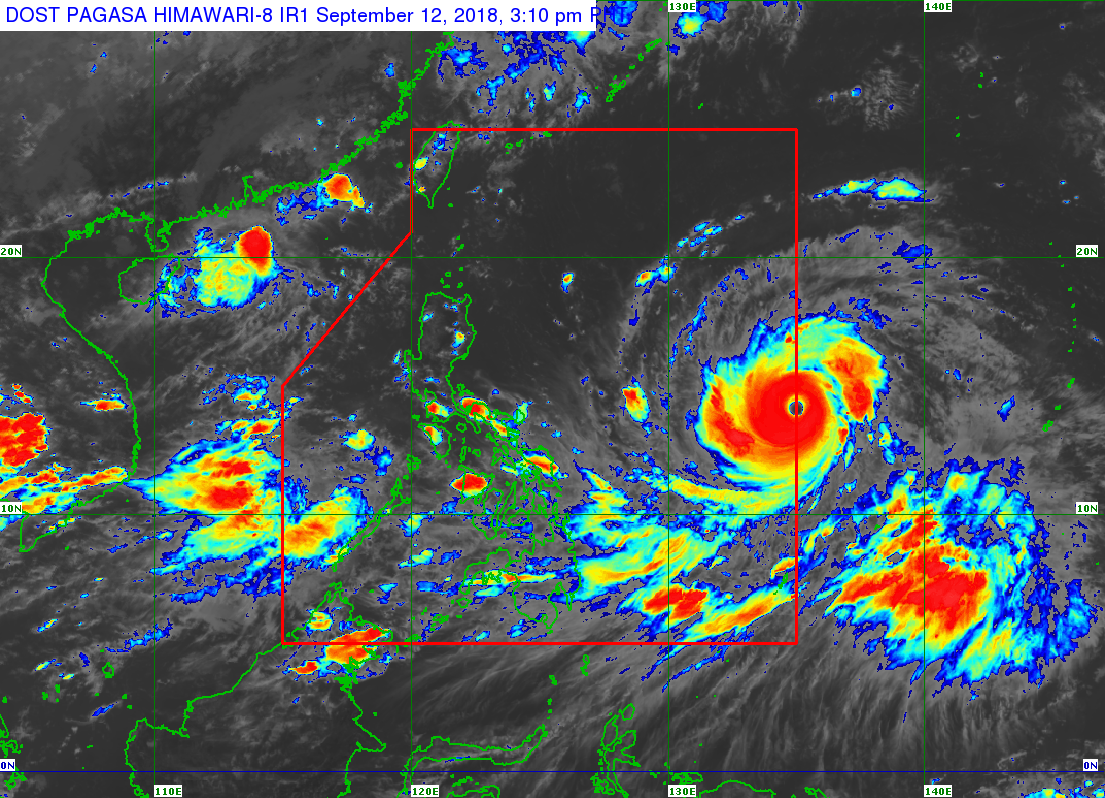
SUPER TYPHOON (STY) 26W (MANGKHUT), LOCATED APPROXIMATELY 826 NM
EAST OF MANILA, PHILIPPINES, HAS TRACKED WESTWARD AT 10 KNOTS OVER
THE PAST SIX HOURS. ANIMATED MULTISPECTRAL SATELLITE IMAGERY SHOWS A
SYMMETRIC AND HIGHLY CONSOLIDATED SYSTEM WITH DEEP COMPACT FEEDER
BANDS SPIRALING TIGHTLY INTO A SHARPLY-OUTLINED 30-NM EYE. THE
INITIAL POSITION IS PLACED WITH HIGH CONFIDENCE BASED ON THE EYE
FEATURE WITH MINOR TILT ADJUSTMENT AS EVIDENCED ON A MICROWAVE EYE
FEATURE IN THE 120545Z 37 GHZ SSMI IMAGE. THE INITIAL INTENSITY OF
150 KNOTS IS BASED ON THE HIGHER END OF DVORAK ESTIMATES OF T7.0/140
KTS FROM RJTD AND T7.5/155 KTS FROM PGTW. UPPER LEVEL ANALYSIS
INDICATES STY 26W IS IN AN AREA OF LOW VERTICAL WIND SHEAR AND
EXCELLENT RADIAL OUTFLOW WITH A STRONG EASTWARD CHANNEL INTO A TUTT
CELL. ALONG-TRACK SEA SURFACE TEMPERATURES IN THE PHILIPPINE SEA AT
28-30 CELSIUS ARE ALSO HIGHLY CONDUCIVE. THE CYCLONE IS TRACKING
ALONG THE SOUTHERN PERIPHERY OF A DEEP-LAYERED EAST-WEST ORIENTED
SUBTROPICAL RIDGE (STR) TO THE NORTH.
3. FORECAST REASONING.
A. THERE IS NO CHANGE TO THE FORECAST PHILOSOPHY FROM THE
PREVIOUS WARNING.
B. STY 26W WILL TRACK MORE WEST-NORTHWESTWARD TOWARD THE NORTHERN
TIP OF LUZON AS THE STR REORIENTS IN RESPONSE TO AN APPROACHING
MIDLATITUDE TROUGH. THE EXCEPTIONALLY FAVORABLE ENVIRONMENTAL
CONDITIONS WILL PERSIST AND SUSTAIN THE CURRENT INTENSITY UP TO TAU
12. AFTERWARD, DIMINISHING EASTWARD OUTFLOW AS THE SYSTEM MOVES AWAY
FROM THE TUTT CELL AND ANTICIPATED INTERACTION WITH LUZON WILL SLOWLY
WEAKEN THE SYSTEM TO 120 KNOTS BY TAU 72 AS IT ENTERS THE SOUTH CHINA
SEA (SCS). INTENSITY FORECASTS REMAIN HIGHER THAN MODEL GUIDANCE,
WHICH HAS PROVEN EFFECTIVE THROUGHOUT THE CURRENT LIFESPAN OF STY
26W. CONFIDENCE IN THIS PORTION OF THE JTWC FORECAST TRACK REMAINS
HIGH BASED ON THE TIGHT GROUPING IN THE NUMERICAL MODEL GUIDANCE.
C. AFTER TAU 72, STY MANGKHUT WILL CONTINUE ON A NORTHWESTWARD
TRAJECTORY UNDER THE STEERING INFLUENCE OF THE STR. THE CYCLONE WILL
TRACK ACROSS THE SCS TOWARD HONG KONG. DIMINISHING OUTFLOW AND
INTERACTION WITH LAND WILL PRIMARILY BE RESPONSIBLE FOR ITS GRADUAL
THEN RAPID DECAY. THE SYSTEM WILL MAKE LANDFALL SOUTHWEST OF HONG
KONG AROUND TAU 102 AT 90 KNOTS THEN WILL BE REDUCED TO A 50-KNOT
SYSTEM BY TAU 120 AS IT TRACKS FURTHER INLAND. THE TRACK GUIDANCE
REMAINS IN TIGHT AGREEMENT WITH CTCX AS THE LONE LEFT-OF-TRACK
OUTLIER. THERE IS ALSO HIGH CONFIDENCE IN THE EXTENDED JTWC FORECAST
TRACK THAT IS LAID JUST RIGHT OF MODEL CONSENSUS TO OFFSET THE
UNLIKELY CTCX SOLUTION.//
NNNN
0 likes   

euro6208

Re: WPAC: MANGKHUT - Typhoon

#457 Postby euro6208 » Wed Sep 12, 2018 5:42 am

Extreme monster.

Image
1 likes   

SconnieCane
Category 4
Category 4
Posts: 998
Joined: Thu Aug 02, 2018 5:29 pm
Location: Madison, WI

Re: WPAC: MANGKHUT - Typhoon

#458 Postby SconnieCane » Wed Sep 12, 2018 5:50 am

:uarrow: Visible appearance getting into Haiyan territory. Dvorak still needs much more CMG though, let alone CDG.
0 likes   

User avatar
doomhaMwx
Category 5
Category 5
Posts: 2454
Age: 26
Joined: Tue Apr 18, 2017 4:01 am
Location: Baguio/Benguet, Philippines
Contact:

Re: WPAC: MANGKHUT - Typhoon

#459 Postby doomhaMwx » Wed Sep 12, 2018 6:02 am

The global models now even more south...

Image
0 likes   

euro6208

Re: WPAC: MANGKHUT - Typhoon

#460 Postby euro6208 » Wed Sep 12, 2018 6:13 am

Image

Look at those crazy OHC before Luzon. It will only get warmer. :eek:
0 likes   


Return to “2018”

Who is online

Users browsing this forum: Google Adsense [Bot], StormWeather and 4 guests