ATL: INVEST 95L - Discussion
Moderator: S2k Moderators


Re: ATL: INVEST 95L - Discussion
Color me skeptical, but I don't see anything coming out of this--the trough to the northwest looks like it's preventing it from closing on that side.
0 likes
The above post is not official and should not be used as such. It is the opinion of the poster and may or may not be backed by sound meteorological data. It is not endorsed by any professional institution or storm2k.org. For official information, please refer to the NHC and NWS products.
-
jaguars_22
- Category 2

- Posts: 629
- Joined: Tue Jun 20, 2017 2:26 pm
- Location: Victoria TX
Re: ATL: INVEST 95L - Discussion
I agree Hammy! There is some new convection popping near the "center"... I wonder if our local nws will put up a tropical storm watch just in case... Can someone post euro rainfall maps?
0 likes

Re: ATL: INVEST 95L - Discussion
If this organizes quickly, we could be looking at history. In the HURDAT going back to 1851, there has never been five named storms at the same time. The last time there was five active systems (including depressions) in the Atlantic was 1995.
7 likes
-
Frank P
- S2K Supporter

- Posts: 2779
- Joined: Fri Aug 29, 2003 10:52 am
- Location: Biloxi Beach, Ms
- Contact:
Re: ATL: INVEST 95L - Discussion
Well is sure looks a lot better than early this morning.. sure looks like a southern TX impact to me... would not be surprised for it to get to a low end TS... hopefully it will give a lot of rain to areas in need... shamelessly glad that Florence is not in the GOM... I've been thru my two 100 hundred years storm already... done with that foolishness...
3 likes

Re: ATL: INVEST 95L - Discussion
Rainfall estimates have dropped considerably for some reason as well.
Euro
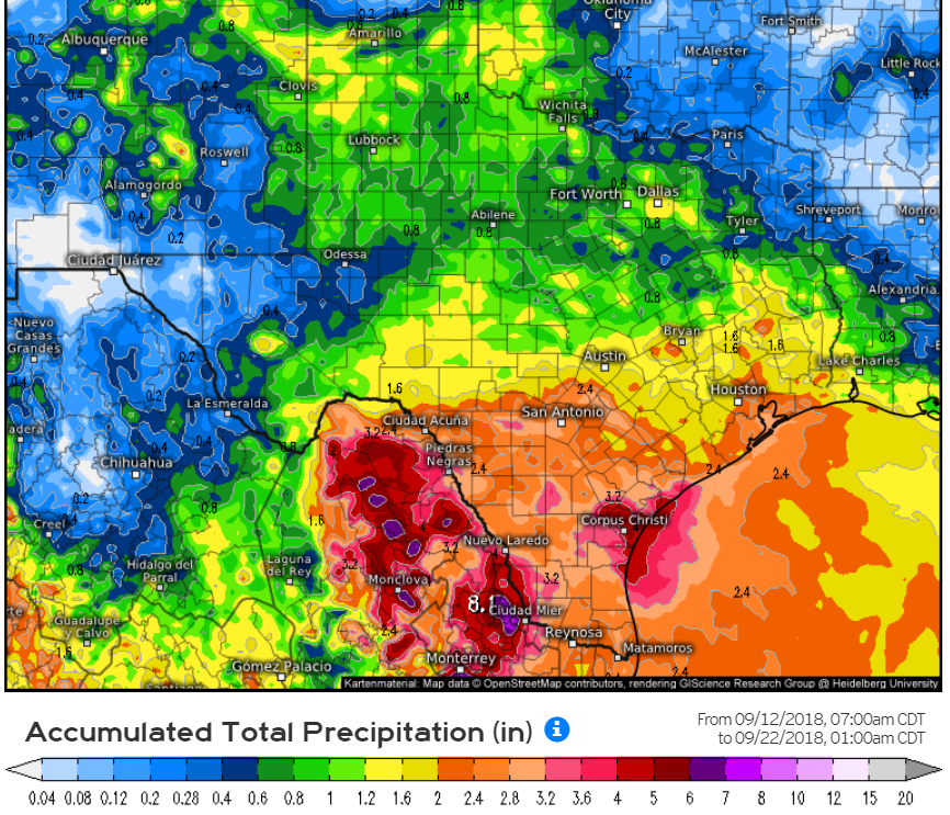
Euro
Last edited by SoupBone on Wed Sep 12, 2018 3:36 pm, edited 1 time in total.
0 likes
Personal Forecast Disclaimer:
The posts in this forum are NOT official forecast and should not be used as such. They are just the opinion of the poster and may or may not be backed by sound meteorological data. They are NOT endorsed by any professional institution or storm2k.org. For official information, please refer to the NHC and NWS products.
The posts in this forum are NOT official forecast and should not be used as such. They are just the opinion of the poster and may or may not be backed by sound meteorological data. They are NOT endorsed by any professional institution or storm2k.org. For official information, please refer to the NHC and NWS products.
-
jaguars_22
- Category 2
- Posts: 629
- Joined: Tue Jun 20, 2017 2:26 pm
- Location: Victoria TX
Re: ATL: INVEST 95L - Discussion
Frank do you think it will move up to middle coast... I'm hoping for some rain here in victoria
0 likes
Re: ATL: INVEST 95L - Discussion
RL3AO wrote:If this organizes quickly, we could be looking at history. In the HURDAT going back to 1851, there has never been five named storms at the same time. The last time there was five active systems (including depressions) in the Atlantic was 1995.
Yep everything is red on the NHC development map right now. Amazing.
0 likes
Re: ATL: INVEST 95L - Discussion
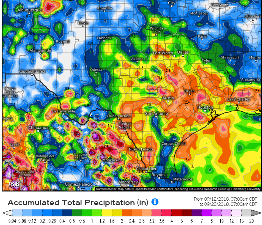
GFS rainfall estimates
0 likes
Personal Forecast Disclaimer:
The posts in this forum are NOT official forecast and should not be used as such. They are just the opinion of the poster and may or may not be backed by sound meteorological data. They are NOT endorsed by any professional institution or storm2k.org. For official information, please refer to the NHC and NWS products.
The posts in this forum are NOT official forecast and should not be used as such. They are just the opinion of the poster and may or may not be backed by sound meteorological data. They are NOT endorsed by any professional institution or storm2k.org. For official information, please refer to the NHC and NWS products.
-
jaguars_22
- Category 2
- Posts: 629
- Joined: Tue Jun 20, 2017 2:26 pm
- Location: Victoria TX
Re: ATL: INVEST 95L - Discussion
If i remember right didnt harvey look horrible one night and then the next it was completely 360. Im not saying this could be a harvey but it could go up to tropical storm strength quick
0 likes
Re: ATL: INVEST 95L - Discussion
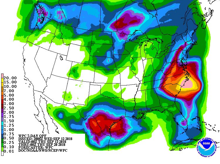
NOAA 7 day Rain Forecast
1 likes
Personal Forecast Disclaimer:
The posts in this forum are NOT official forecast and should not be used as such. They are just the opinion of the poster and may or may not be backed by sound meteorological data. They are NOT endorsed by any professional institution or storm2k.org. For official information, please refer to the NHC and NWS products.
The posts in this forum are NOT official forecast and should not be used as such. They are just the opinion of the poster and may or may not be backed by sound meteorological data. They are NOT endorsed by any professional institution or storm2k.org. For official information, please refer to the NHC and NWS products.
-
somethingfunny

- ChatStaff

- Posts: 3926
- Age: 37
- Joined: Thu May 31, 2007 10:30 pm
- Location: McKinney, Texas
Re: ATL: INVEST 95L - Discussion
jaguars_22 wrote:If i remember right didnt harvey look horrible one night and then the next it was completely 360. Im not saying this could be a harvey but it could go up to tropical storm strength quick
Harvey had a lot more model support than this one does. I'm feeling 50-50 on this one.
0 likes
I am not a meteorologist, and any posts made by me are not official forecasts or to be interpreted as being intelligent. These posts are just my opinions and are probably silly opinions.
-
jaguars_22
- Category 2
- Posts: 629
- Joined: Tue Jun 20, 2017 2:26 pm
- Location: Victoria TX
-
Frank P
- S2K Supporter
- Posts: 2779
- Joined: Fri Aug 29, 2003 10:52 am
- Location: Biloxi Beach, Ms
- Contact:
Re: ATL: INVEST 95L - Discussion
jaguars_22 wrote:Frank do you think it will move up to middle coast... I'm hoping for some rain here in victoria
I would think that is certainly possible... should be a decent rain maker for TX.... probably most of the weather will be on the east side of the system... I would think that the middle coast certainly should see some of that rainfall... Hope ya get it too Jaguars 22 !
0 likes
-
shiny-pebble
- Category 1

- Posts: 299
- Joined: Thu Jul 05, 2018 1:38 pm
Re: ATL: INVEST 95L - Discussion
Although not too likely, I wouldn't be surprised if we get a Humberto '07 or probably more likely, an Emily '17 out of this. A storm that quickly forms or intensifies near landfall.
Sent from my LG-H700 using Tapatalk
Sent from my LG-H700 using Tapatalk
0 likes
Not an meteorologist! Just someone who is interested in weather. Please refer to the NHC and local weather officials to make decisions.
-Jack
-Jack
-
jaguars_22
- Category 2
- Posts: 629
- Joined: Tue Jun 20, 2017 2:26 pm
- Location: Victoria TX
Re: ATL: INVEST 95L - Discussion
Its probably going to die out again tonight? Wouldnt you think?
0 likes
Re: ATL: INVEST 95L - Discussion
I honestly can't tell where the center is located. Anyone? Bueller?
0 likes
Personal Forecast Disclaimer:
The posts in this forum are NOT official forecast and should not be used as such. They are just the opinion of the poster and may or may not be backed by sound meteorological data. They are NOT endorsed by any professional institution or storm2k.org. For official information, please refer to the NHC and NWS products.
The posts in this forum are NOT official forecast and should not be used as such. They are just the opinion of the poster and may or may not be backed by sound meteorological data. They are NOT endorsed by any professional institution or storm2k.org. For official information, please refer to the NHC and NWS products.
-
jaguars_22
- Category 2
- Posts: 629
- Joined: Tue Jun 20, 2017 2:26 pm
- Location: Victoria TX
Re: ATL: INVEST 95L - Discussion
SoupBone I thought it was still down north of the yucatan. but tropical tidbits is showing it closer to mexico/ texas border directly under the convection ball...
0 likes

Re: ATL: INVEST 95L - Discussion
I honestly can't tell where the center is located. Anyone? Bueller?
23.7°N 91.7°W
0 likes
-
jaguars_22
- Category 2
- Posts: 629
- Joined: Tue Jun 20, 2017 2:26 pm
- Location: Victoria TX
Re: ATL: INVEST 95L - Discussion
What does the wind shear look like... Jon Metz just said via conference that the wind shear is high and prevent any development of this system... beyond TD status?? Wind Shear map?
0 likes
-
Stormcenter
- S2K Supporter
- Posts: 6689
- Joined: Wed Sep 03, 2003 11:27 am
- Location: Houston, TX
Re: ATL: INVEST 95L - Discussion
Th center doesn't look like it's anywhere near where the NHC has it. It may be near that new blow-up of convection further
to the east of where the NHC has it. IMO
https://cdn.star.nesdis.noaa.gov/GOES16 ... 0x1000.gif
to the east of where the NHC has it. IMO
https://cdn.star.nesdis.noaa.gov/GOES16 ... 0x1000.gif
EasyTiger wrote:I honestly can't tell where the center is located. Anyone? Bueller?
23.7°N 91.7°W
0 likes
Who is online
Users browsing this forum: No registered users and 58 guests