ATL: FLORENCE - Post-Tropical - Discussion

Moderator: S2k Moderators

Message
Author
ozonepete
Professional-Met
Professional-Met
Posts: 4743
Joined: Mon Sep 07, 2009 3:23 pm
Location: From Ozone Park, NYC / Now in Brooklyn, NY

Re: ATL: FLORENCE - Hurricane - Discussion

#3741 Postby ozonepete » Thu Sep 13, 2018 7:39 am

weathaguyry wrote:Yup, Sandy had “only Cat 1 force winds in NY” and it took a month for our power to be restored, our roof was severely damaged, our siding peeled off, and roughly 3/4 of the trees in our town either fell directly from the wind, or died due to the saltwater intrusion into the soil and fell at a later date, so sure, Cat 1 winds aren’t a big deal at all


Yes, you are so right. I was there for Sandy and remember it well. 43 people died in the 5 boroughs of NYC alone. It was the constant wind for such a long time and of course the surge that kept coming in across multiple tide cycles. This could be a very similar situation if it stalls or drifts anywhere near the coast.
4 likes   

tallywx
Category 2
Category 2
Posts: 790
Joined: Thu Jul 03, 2003 10:19 am
Location: Raleigh/Durham, NC

Re: ATL: FLORENCE - Hurricane - Discussion

#3742 Postby tallywx » Thu Sep 13, 2018 7:41 am

NDG wrote:
invest man wrote:
NDG wrote:Eye is now closed.

https://i.imgur.com/lW7fNea.gif

It's looking mighty healthy this morning! Better than most of yesterday. You think NHC may put out special statement if it kicks back up to cat 3 before 11? Looks very probable that it's there now to my untrained eyes!


I doubt that it will get back up to a Cat 3 by that time, any significant further strengthening may happen later today or tonight, it has to finish getting rid of that dry air slot that got entrained into it yesterday. IMO.


It’s over the Gulf Stream right now so if it’s going to make one last run, now is the time.
0 likes   

User avatar
GCANE
S2K Supporter
S2K Supporter
Posts: 11500
Joined: Mon Oct 22, 2007 8:03 am

Re: ATL: FLORENCE - Hurricane - Discussion

#3743 Postby GCANE » Thu Sep 13, 2018 7:42 am

Still a lot of water time left.
Watching for the convective cap to break this afternoon.

Image
0 likes   

User avatar
TheDreamTraveler
Category 2
Category 2
Posts: 641
Joined: Sun Aug 22, 2010 3:10 am
Location: PA

Re: ATL: FLORENCE - Hurricane - Discussion

#3744 Postby TheDreamTraveler » Thu Sep 13, 2018 7:47 am

A few meteorologists are comparing this to a more impactful version of Ike despite it's strength. And I think I believe them. Despite Ike's weak strength the wind field was massive and the surge was still equivalent of a cat 4. Take Florence and add those impacts but add flooding rains of up to 40 inches on top of that among a few other things. Oh and also the duration of tropical storm/hurricane winds will be double or triple what we typically see with storms moving by.
1 likes   

User avatar
GCANE
S2K Supporter
S2K Supporter
Posts: 11500
Joined: Mon Oct 22, 2007 8:03 am

Re: ATL: FLORENCE - Hurricane - Discussion

#3745 Postby GCANE » Thu Sep 13, 2018 7:50 am

70F+ dewpoint well inland.
No inhibition here.
Might blow up this afternoon.

Image
1 likes   

tolakram
Admin
Admin
Posts: 20012
Age: 62
Joined: Sun Aug 27, 2006 8:23 pm
Location: Florence, KY (name is Mark)

Re: ATL: FLORENCE - Hurricane - Discussion

#3746 Postby tolakram » Thu Sep 13, 2018 7:53 am

004
URNT12 KNHC 131229 CCA
VORTEX DATA MESSAGE AL062018
A. 13/11:45:40Z
B. 33.08 deg N 075.15 deg W
C. 700 mb 2720 m
D. 957 mb
E. 120 deg 6 kt
F. OPEN NE
G. C20
H. 76 kt
I. 227 deg 13 nm 11:41:30Z
J. 318 deg 79 kt
K. 227 deg 13 nm 11:41:30Z
L. 71 kt
M. 045 deg 18 nm 11:51:00Z
N. 133 deg 90 kt
O. 046 deg 21 nm 11:52:00Z
P. 12 C / 3052 m
Q. 16 C / 3049 m
R. NA / NA
S. 12345 / 7
T. 0.02 / 2 nm
U. AF302 1406A FLORENCE OB 03 CCA
MAX FL WIND 90 KT 046 / 21 NM 11:52:00Z
;
0 likes   
M a r k
- - - - -
Join us in chat: Storm2K Chatroom Invite. Android and IOS apps also available.

The posts in this forum are NOT official forecasts and should not be used as such. Posts are NOT endorsed by any professional institution or STORM2K.org. For official information and forecasts, please refer to NHC and NWS products.

User avatar
NDG
S2K Supporter
S2K Supporter
Posts: 15446
Joined: Sun Jul 09, 2006 10:14 pm
Location: Orlando, FL

Re: ATL: FLORENCE - Hurricane - Discussion

#3747 Postby NDG » Thu Sep 13, 2018 7:53 am

tallywx wrote:
NDG wrote:
invest man wrote:It's looking mighty healthy this morning! Better than most of yesterday. You think NHC may put out special statement if it kicks back up to cat 3 before 11? Looks very probable that it's there now to my untrained eyes!


I doubt that it will get back up to a Cat 3 by that time, any significant further strengthening may happen later today or tonight, it has to finish getting rid of that dry air slot that got entrained into it yesterday. IMO.


It’s over the Gulf Stream right now so if it’s going to make one last run, now is the time.


It is just starting to track over the gulf stream, but it the dry air doesn't get mixed out soon it will not matter that it will be tracking over the very warm waters.
0 likes   

User avatar
Hurricane Andrew
S2K Supporter
S2K Supporter
Posts: 1891
Age: 26
Joined: Sun May 23, 2010 2:53 pm
Location: KS

Re: ATL: FLORENCE - Hurricane - Discussion

#3748 Postby Hurricane Andrew » Thu Sep 13, 2018 7:55 am

Helpful link to watch today...

https://poweroutage.us
3 likes   

The Enthusiast
NREMT-AEMT, WX nerd

Irene '11, Sandy '12, Irma '17 (SAR)

"Hard to think we were born to live this way..." -Wage War

User avatar
GCANE
S2K Supporter
S2K Supporter
Posts: 11500
Joined: Mon Oct 22, 2007 8:03 am

Re: ATL: FLORENCE - Hurricane - Discussion

#3749 Postby GCANE » Thu Sep 13, 2018 7:56 am

Image

Image
0 likes   

xironman
S2K Supporter
S2K Supporter
Posts: 2522
Joined: Sun Jun 10, 2007 4:53 pm
Location: NoVA

Re: ATL: FLORENCE - Hurricane - Discussion

#3750 Postby xironman » Thu Sep 13, 2018 7:56 am

Atlantic Beach webcam https://www.wnct.com/weather/webcams/li ... ntic-beach

The sea was angry that day ....
2 likes   

User avatar
Cypresso
S2K Supporter
S2K Supporter
Posts: 61
Age: 68
Joined: Thu Aug 30, 2018 11:39 pm
Location: Houston, Texas

Re: ATL: FLORENCE - Hurricane - Discussion

#3751 Postby Cypresso » Thu Sep 13, 2018 7:58 am

TheDreamTraveler wrote:A few meteorologists are comparing this to a more impactful version of Ike despite it's strength. And I think I believe them. Despite Ike's weak strength the wind field was massive and the surge was still equivalent of a cat 4. Take Florence and add those impacts but add flooding rains of up to 40 inches on top of that among a few other things. Oh and also the duration of tropical storm/hurricane winds will be double or triple what we typically see with storms moving by.


I am in agreement. I had Ike right over my head and have vivid memories. Nothing like seeing things flying around at eye level two stories up. Large things, BBQ grills, lawn furniture and of course parts of trees. This was in Houston, not Galveston, btw.
5 likes   
Houston, Texas. Allison '01, Rita '05, Dolly '08, Ike '08, Issac '12, Harvey '17

User avatar
artist
Category 5
Category 5
Posts: 9792
Joined: Mon Jun 06, 2005 3:26 pm
Location: West Palm

Re: ATL: FLORENCE - Hurricane - Discussion

#3752 Postby artist » Thu Sep 13, 2018 7:59 am

[youtube]https://youtu.be/Q-neItrE5ec[/youtube]
1 likes   

User avatar
NDG
S2K Supporter
S2K Supporter
Posts: 15446
Joined: Sun Jul 09, 2006 10:14 pm
Location: Orlando, FL

Re: ATL: FLORENCE - Hurricane - Discussion

#3753 Postby NDG » Thu Sep 13, 2018 8:01 am

tolakram wrote:
004
URNT12 KNHC 131229 CCA
VORTEX DATA MESSAGE AL062018
A. 13/11:45:40Z
B. 33.08 deg N 075.15 deg W
C. 700 mb 2720 m
D. 957 mb
E. 120 deg 6 kt
F. OPEN NE
G. C20
H. 76 kt
I. 227 deg 13 nm 11:41:30Z
J. 318 deg 79 kt
K. 227 deg 13 nm 11:41:30Z
L. 71 kt
M. 045 deg 18 nm 11:51:00Z
N. 133 deg 90 kt
O. 046 deg 21 nm 11:52:00Z
P. 12 C / 3052 m
Q. 16 C / 3049 m
R. NA / NA
S. 12345 / 7
T. 0.02 / 2 nm
U. AF302 1406A FLORENCE OB 03 CCA
MAX FL WIND 90 KT 046 / 21 NM 11:52:00Z
;


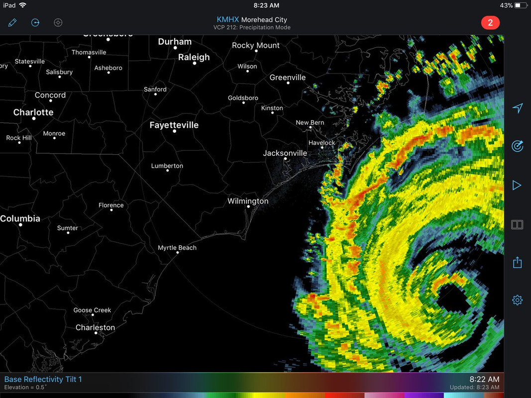
Yes, but the pass was when it was still open, time slot on radar also showed that it was open but since then the radar shows that is trying really hard to keep it closed.

Image
Image
2 likes   

supercane4867
Category 5
Category 5
Posts: 4966
Joined: Wed Nov 14, 2012 10:43 am

Re: ATL: FLORENCE - Hurricane - Discussion

#3754 Postby supercane4867 » Thu Sep 13, 2018 8:03 am

Seems to be reorganizing this morning. It's also trying to form a ultra large outer eyewall that will further extend hurricane force windfield.

Image
0 likes   

User avatar
artist
Category 5
Category 5
Posts: 9792
Joined: Mon Jun 06, 2005 3:26 pm
Location: West Palm

Re: ATL: FLORENCE - Hurricane - Discussion

#3755 Postby artist » Thu Sep 13, 2018 8:03 am

Wilmington, NC live stream
FEMA conference coming up. Wect
http://ftpcontent4.worldnow.com/raycom/ ... livestream
Last edited by artist on Thu Sep 13, 2018 8:04 am, edited 1 time in total.
2 likes   

SconnieCane
Category 4
Category 4
Posts: 998
Joined: Thu Aug 02, 2018 5:29 pm
Location: Madison, WI

Re: ATL: FLORENCE - Hurricane - Discussion

#3756 Postby SconnieCane » Thu Sep 13, 2018 8:04 am

I've seen a lot of comparisons to Ike in this thread. I haven't seen it (although it may have been) pointed out already that, fittingly, Florence is approaching the NC coast on the 10th anniversary of Ike's Texas landfall.

Ike is the storm that to me should put a big asterisk on the US "12-year major landfall drought" from Wilma to Harvey. It was 1 MPH below the threshold and strengthening on approach, so another hour over water might well have done it, and it was certainly "major" in its impacts.
2 likes   

Vdogg
Category 2
Category 2
Posts: 621
Joined: Wed Aug 31, 2016 9:56 am

Re: ATL: FLORENCE - Hurricane - Discussion

#3757 Postby Vdogg » Thu Sep 13, 2018 8:06 am

supercane4867 wrote:Seems to be reorganizing this morning. It's also trying to form a ultra large outer eyewall that will further extend hurricane force windfield.

https://i.imgur.com/Whzzzpc.jpg

No way. With an eye that large hurricane force winds would easily be into Hampton roads. Would it contract? What's the largest eye a hurricane has ever had?

Edit: NVM :double:

"Eyes can range in size from 370 km (230 mi) (Typhoon Carmen)[9] to a mere 3.7 km (2.3 mi) (Hurricane Wilma) across.[10] While it is uncommon for storms with large eyes to become very intense, it does occur, especially in annular hurricanes. Hurricane Isabel was the eleventh most powerful North Atlantic hurricane in recorded history, and sustained a large, 65–80 km (40–50 mi)-wide eye for a period of several days."
Last edited by Vdogg on Thu Sep 13, 2018 8:10 am, edited 1 time in total.
0 likes   

bjackrian
S2K Supporter
S2K Supporter
Posts: 156
Joined: Wed Aug 17, 2005 12:41 pm
Location: Denver, CO

Re: ATL: FLORENCE - Hurricane - Discussion

#3758 Postby bjackrian » Thu Sep 13, 2018 8:07 am

KMRH already reporting 29kt sustained with TS gusts to 44kt last hour.

https://www.aviationweather.gov/metar/data?ids=KMRH&format=raw&date=0&hours
2 likes   

User avatar
NDG
S2K Supporter
S2K Supporter
Posts: 15446
Joined: Sun Jul 09, 2006 10:14 pm
Location: Orlando, FL

Re: ATL: FLORENCE - Hurricane - Discussion

#3759 Postby NDG » Thu Sep 13, 2018 8:08 am

Those squalls approaching the coast already have winds close to hurricane force, per the recon. 120 miles NW of the eye.
2 likes   

User avatar
artist
Category 5
Category 5
Posts: 9792
Joined: Mon Jun 06, 2005 3:26 pm
Location: West Palm

Re: ATL: FLORENCE - Hurricane - Discussion

#3760 Postby artist » Thu Sep 13, 2018 8:08 am

Image
1 likes   


Return to “2018”

Who is online

Users browsing this forum: No registered users and 1 guest