ATL: INVEST 95L - Discussion
Moderator: S2k Moderators
Re: ATL: INVEST 95L - Discussion
Could future Kirk be another lopsided system like Gordon?
0 likes
Personal Forecast Disclaimer:
The posts in this forum are NOT official forecast and should not be used as such. They are just the opinion of the poster and may or may not be backed by sound meteorological data. They are NOT endorsed by any professional institution or storm2k.org. For official information, please refer to the NHC and NWS products.
The posts in this forum are NOT official forecast and should not be used as such. They are just the opinion of the poster and may or may not be backed by sound meteorological data. They are NOT endorsed by any professional institution or storm2k.org. For official information, please refer to the NHC and NWS products.
-
Portastorm

- Storm2k Moderator

- Posts: 9955
- Age: 63
- Joined: Fri Jul 11, 2003 9:16 am
- Location: Round Rock, TX
- Contact:
Re: ATL: INVEST 95L - Discussion
Wednesday afternoon briefing from Jeff re: 95L:
95L:
Satellite images suggest that a broad area of surface low pressure has formed today over the south-central Gulf of Mexico and thunderstorms activity has increased somewhat although it remains fairly disorganized. Based on the current data there is a 70% chance that a tropical depression will form in the next 24 hours over the western Gulf of Mexico. This feature is generally moving toward the NW at around 10mph and will be approaching the lower or middle TX coast on Friday. Conditions across the NW Gulf of Mexico will gradually become more favorable for the development of a tropical depression or storm over the next 24-36 hours and it is possible if not likely that the broad surface low will consolidate as it nears the coast on Friday.
Regardless of this system being declared a tropical storm or depression, the impacts along the TX coast will be nearly the same….heavy rainfall and potential flooding.
A Flash Flood Watch has been issued from midnight tonight to 700pm Thursday for all the coastal counties and SE Harris County where rainfall over the last 2-3 days has averaged 3-6 inches with isolated totals of up to 10 inches. Grounds over these areas are saturated and additional rainfall is expected to develop again overnight and impact many of these same areas.
Rainbands from 95L will begin to spread onto the TX coast late Thursday and increase into Thursday night and Friday and continue into Saturday. Widespread rainfall amounts of 2-4 inches will be common mainly south of I-10 tonight-Saturday night with isolated totals of 6-8 inches. North of I-10 rainfall amounts will likely average 1-3 inches with isolated totals of up to 4 inches. There is still some uncertainty with these rainfall numbers and they could change up or down in the next 24-48 hours.
The greatest threat for flooding will be over the areas that have experienced the most rainfall over the last several days or generally across the coastal counties and into SE Harris County and then further inland over the coastal bend and SW TX where rainfall has been plentiful and rivers already running high.
Will maintain winds of 10-20mph inland and 15-25mph along the coast an offshore unless the system becomes stronger than currently expected.
Tides will run about 1.0-1.5 feet above predicted levels along the coast with total water levels of 3.0-3.5 feet above MLLW which is generally below thresholds needed to cause issues along Bolivar, the west end of Galveston and along the west side of Galveston Bay.
0 likes
Any forecasts under my name are to be taken with a grain of salt. Get your best forecasts from the National Weather Service and National Hurricane Center.
-
HurricaneBelle

- S2K Supporter

- Posts: 1209
- Joined: Sun Aug 27, 2006 6:12 pm
- Location: Clearwater, FL
Re: ATL: INVEST 95L - Discussion
If this ends up Kirk, wxman57 is going to have to update his meme to "You're dead, Jim" when it dissipates.
6 likes
-
cycloneye

- Admin

- Posts: 149367
- Age: 69
- Joined: Thu Oct 10, 2002 10:54 am
- Location: San Juan, Puerto Rico
Re: ATL: INVEST 95L - Discussion
8 PM TWO:
A broad area of low pressure is located over the central Gulf of
Mexico. Although the shower activity is still disorganized,
upper-level winds are forecast to become more conducive for
development, and it is likely that a tropical depression will form
Thursday or Thursday night, before the system reaches the western
Gulf coast. An Air Force Reserve Hurricane Hunter aircraft is
scheduled to investigate the disturbance tomorrow, if necessary.
Regardless of development, heavy rainfall and gusty winds are
expected across portions of northeastern Mexico, Texas, and
Louisiana late this week. Interests there should monitor the
progress of this system, and refer to products from their local
weather office.
* Formation chance through 48 hours...high...70 percent.
* Formation chance through 5 days...high...70 percent.
.
1 likes
Visit the Caribbean-Central America Weather Thread where you can find at first post web cams,radars
and observations from Caribbean basin members Click Here
and observations from Caribbean basin members Click Here

Re: ATL: INVEST 95L - Discussion
The convection doesn't look all that great right now, but the circulation is definitely improving.
0 likes

Re: ATL: INVEST 95L - Discussion
EasyTiger wrote:The convection doesn't look all that great right now, but the circulation is definitely improving.
Maybe it rolls tomorrow or tomorrow night. NHc assumes a depression will form, but obviously it’s got to happen for them to be right. More concentrated rains in the NW Gulf on the NAM but that's prerunner stuff and only out to 13 hours. NAM hasn’t been aggressive and mostly has only shown 1 closed insobar.
0 likes
-
wxman22

- Category 5

- Posts: 1920
- Joined: Mon Jan 30, 2006 12:39 am
- Location: Wichita Falls, TX
- Contact:
Re: ATL: INVEST 95L - Discussion
95L is looking better organized this morning lets see if the trend continues through the day, the reconnaissance flight scheduled for today hasn't been cancelled yet.
1 likes
-
South Texas Storms

- Professional-Met

- Posts: 4256
- Joined: Thu Jun 24, 2010 12:28 am
- Location: Houston, TX
Re: ATL: INVEST 95L - Discussion
The disturbance is trying to develop, with plenty of convection firing this morning. It's running out of time though, with landfall expected tomorrow. NHC lowered the chance of development to 50%.
1 likes
-
jaguars_22
- Category 2

- Posts: 629
- Joined: Tue Jun 20, 2017 2:26 pm
- Location: Victoria TX
Re: ATL: INVEST 95L - Discussion
SO lanfall is going to be well south of my area in Victoria? Looks like mexico...
0 likes
Re: ATL: INVEST 95L - Discussion
SO lanfall is going to be well south of my area in Victoria? Looks like mexico...
Really depends on how much the system strengthens. Looking at the current steering map, if it remains weak, south Texas is likely. If it were to somehow get a little stronger than middle Texas coast isn't out of the question.
http://tropic.ssec.wisc.edu/real-time/dlmmain.php?&basin=atlantic&sat=wg8&prod=dlm1&zoom=&time=
0 likes
Re: ATL: INVEST 95L - Discussion
This thing really seems to be getting it's act together.
https://weather.cod.edu/satrad/exper/?parms=regional-gulf-14-24-1-100-1&checked=map&colorbar=undefined
https://weather.cod.edu/satrad/exper/?parms=regional-gulf-14-24-1-100-1&checked=map&colorbar=undefined
1 likes
Re: ATL: INVEST 95L - Discussion
jaguars_22 wrote:SO lanfall is going to be well south of my area in Victoria? Looks like mexico...
Looks like it may run out of Gulf real estate, but if it was going to develop or deepen, it would be today. I could see a non TD spinning up as it's hitting the coast tomorrow sometime. But in any event, the weather looks to be all on the north side. You can already see some banding up along the coast of Louisiana where the boundary meets the circulation, so your chances of rain in Victoria should be pretty good over the next 36-48 hours.
https://weather.cod.edu/satrad/exper/?p ... =undefined
S MS Valley Composite Radar
https://radar.weather.gov/ridge/Conus/s ... y_loop.php
0 likes
-
jaguars_22
- Category 2
- Posts: 629
- Joined: Tue Jun 20, 2017 2:26 pm
- Location: Victoria TX
Re: ATL: INVEST 95L - Discussion
i just dont understand why we are only supposed to get 1-2 inches
0 likes
-
South Texas Storms
- Professional-Met
- Posts: 4256
- Joined: Thu Jun 24, 2010 12:28 am
- Location: Houston, TX
Re: ATL: INVEST 95L - Discussion
jaguars_22 wrote:i just dont understand why we are only supposed to get 1-2 inches
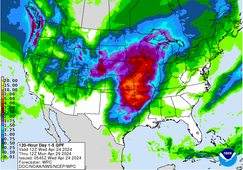
Not sure where you're seeing that. The latest WPC rainfal forecast looks quite reasonable. It shows 2-4 inches for much of south TX.
https://www.wpc.ncep.noaa.gov/qpf/p120i.gif?1536846563
1 likes
-
jaguars_22
- Category 2
- Posts: 629
- Joined: Tue Jun 20, 2017 2:26 pm
- Location: Victoria TX
Re: ATL: INVEST 95L - Discussion
LOL thats just going with what the conference said yesterday... Looks like on the sattelite the center could form under the north east part of convection??
0 likes
-
craptacular
- Category 2
- Posts: 581
- Joined: Wed Aug 02, 2006 9:17 pm
- Location: The Mad City, WI
-
jasons2k

- Storm2k Executive
- Posts: 8290
- Age: 52
- Joined: Wed Jul 06, 2005 12:32 pm
- Location: The Woodlands, TX
Re: ATL: INVEST 95L - Discussion
95L, while small, certainly looks more organized today. The low cloud movement indicates a closed low has formed. Also, you can see the cirrus is fanning out in all directions from the convection, indicating that shear had finally dropped. I think it still has a good chance of being declared a depression or a TS. It sure is pretty far south though.
1 likes

Re: ATL: INVEST 95L - Discussion
jasons wrote:95L, while small, certainly looks more organized today. The low cloud movement indicates a closed low has formed. Also, you can see the cirrus is fanning out in all directions from the convection, indicating that shear had finally dropped. I think it still has a good chance of being declared a depression or a TS. It sure is pretty far south though.
It's heading to an area that badly needs rain too, that far south. Hopefully, the rain can help pull them out of the drought conditions, slowly.
0 likes
Personal Forecast Disclaimer:
The posts in this forum are NOT official forecast and should not be used as such. They are just the opinion of the poster and may or may not be backed by sound meteorological data. They are NOT endorsed by any professional institution or storm2k.org. For official information, please refer to the NHC and NWS products.
The posts in this forum are NOT official forecast and should not be used as such. They are just the opinion of the poster and may or may not be backed by sound meteorological data. They are NOT endorsed by any professional institution or storm2k.org. For official information, please refer to the NHC and NWS products.
-
jaguars_22
- Category 2
- Posts: 629
- Joined: Tue Jun 20, 2017 2:26 pm
- Location: Victoria TX
Re: ATL: INVEST 95L - Discussion
I'm guessing landfall will be mexico... Where do you have the center located? Jason?
0 likes
Re: ATL: INVEST 95L - Discussion
For the sake of science and stats, I'm pulling for Kirk, but it's really the last thing the United States needs. If this forms and hits the Gulf Coast it would be the 4th system in 10 days to landfall in the U.S. somewhere. 
0 likes
Who is online
Users browsing this forum: No registered users and 9 guests