ATL: ISAAC - Post-Tropical - Discussion
Moderator: S2k Moderators
Re: ATL: ISAAC - Tropical Depression - Discussion
The NHC, EURO AND GFS see it dying out. We'll see what happens
0 likes
-
BigB0882
- S2K Supporter

- Posts: 2292
- Joined: Thu Jul 03, 2003 12:08 am
- Location: Baton Rouge, LA
- Contact:
Re: ATL: ISAAC - Tropical Depression - Discussion
Saying a storm will die out is a bit misleading because that does not mean it can't regenerate later.
1 likes
-
Gustywind

- Category 5

- Posts: 12334
- Joined: Mon Sep 03, 2007 7:29 am
- Location: Baie-Mahault, GUADELOUPE
Re: ATL: ISAAC - Tropical Depression - Discussion
StruThiO wrote:https://i.imgur.com/VravkvS.jpg
Hope he will stay weak and do not move close to any land especially in the Greater Antilles.
1 likes
-
Gustywind
- Category 5
- Posts: 12334
- Joined: Mon Sep 03, 2007 7:29 am
- Location: Baie-Mahault, GUADELOUPE
Re: ATL: ISAAC - Evacuations, Closing and Observations
YES! We have been fully spared from poor TS Isaac! Thanks to you Isaac polite little boy. I hope that Isaac stay at this status along it treks, but only Mother Nature knows why. Even rainfall values are extremely week only 45 millimeters in a area close in hig elevation close to our volcano la Soufriere , elsewhere 5 millimiters in some others areas. So good excellent news, no damages, schools are open, all is at green code! 

2 likes

Re: ATL: ISAAC - Tropical Depression - Discussion
convection continues to fire on or near the Coc if one still exist. Definetly needs to be watched. I expect him to lose its clothes again later today but regain convection tonight during d-max.
0 likes
The following post is NOT an official forecast and should not be used as such. It is just the opinion of the poster and may or may not be backed by sound meteorological data. It is NOT endorsed by any professional institution including storm2k.org For Official Information please refer to the NHC and NWS products.

Re: ATL: ISAAC - Evacuations, Closing and Observations
msbee wrote:Tropical storm watch for St Maarten has been discontinued
Awesome news Barb!
0 likes

Re: ATL: ISAAC - Tropical Depression - Discussion
caneman wrote:The NHC, EURO AND GFS see it dying out. We'll see what happens
What the NHC, my mets, etc. are waiting on is this area of shear that's been increasing in that small pocket. My mets are forecasting potential dissipation just SE of Jamaica on Sunday, so that day is critical for his survival or "poof". If you look at the GFS over the last 2-3 runs, that poof moment comes right SE of Jamaica.
Last edited by SoupBone on Fri Sep 14, 2018 8:56 am, edited 1 time in total.
1 likes
Personal Forecast Disclaimer:
The posts in this forum are NOT official forecast and should not be used as such. They are just the opinion of the poster and may or may not be backed by sound meteorological data. They are NOT endorsed by any professional institution or storm2k.org. For official information, please refer to the NHC and NWS products.
The posts in this forum are NOT official forecast and should not be used as such. They are just the opinion of the poster and may or may not be backed by sound meteorological data. They are NOT endorsed by any professional institution or storm2k.org. For official information, please refer to the NHC and NWS products.
Re: ATL: ISAAC - Tropical Depression - Discussion
The dry air he was dealing with is all but gone.
1 likes
Personal Forecast Disclaimer:
The posts in this forum are NOT official forecast and should not be used as such. They are just the opinion of the poster and may or may not be backed by sound meteorological data. They are NOT endorsed by any professional institution or storm2k.org. For official information, please refer to the NHC and NWS products.
The posts in this forum are NOT official forecast and should not be used as such. They are just the opinion of the poster and may or may not be backed by sound meteorological data. They are NOT endorsed by any professional institution or storm2k.org. For official information, please refer to the NHC and NWS products.
-
northjaxpro

- S2K Supporter
- Posts: 8900
- Joined: Mon Sep 27, 2010 11:21 am
- Location: Jacksonville, FL
Re: ATL: ISAAC - Tropical Depression - Discussion
Yeah, convection indeed has flared back up with Isaac the past 6-12 hours. Conditions just may be improving indeed for Isaac to get its act together ad he moves further into the NW Caribbean the next few days.
0 likes
NEVER, EVER SAY NEVER in the tropics and weather in general, and most importantly, with life itself!!
________________________________________________________________________________________
Fay 2008 Beryl 2012 Debby 2012 Colin 2016 Hermine 2016 Julia 2016 Matthew 2016 Irma 2017 Dorian 2019
________________________________________________________________________________________
Fay 2008 Beryl 2012 Debby 2012 Colin 2016 Hermine 2016 Julia 2016 Matthew 2016 Irma 2017 Dorian 2019
-
Hurricane Andrew

- S2K Supporter
- Posts: 1891
- Age: 27
- Joined: Sun May 23, 2010 2:53 pm
- Location: KS
Re: ATL: ISAAC - Tropical Depression - Discussion
Definitely bears watching...as in the past, we've had some bad experiences with weak storms that regenerated/strengthened in the Gulf. I don't think I need to name names, unfortunately.
1 likes
The Enthusiast
NREMT-AEMT, WX nerd
Irene '11, Sandy '12, Irma '17 (SAR)
"Hard to think we were born to live this way..." -Wage War
-
StruThiO

- Category 3

- Posts: 821
- Age: 26
- Joined: Fri Sep 15, 2017 5:51 am
- Location: Currently Portland, OR. Raised in Jax, FL.
Re: ATL: ISAAC - Tropical Depression - Discussion
"Vertical shear has decreased near Isaac, with some outflow in the
western semicircle noted and consolidation of the convection.
Still, this area of the eastern Caribbean isn't known as the
graveyard for nothing, and the system might just be too shallow and
disorganized to take advantage of the changing environment."

western semicircle noted and consolidation of the convection.
Still, this area of the eastern Caribbean isn't known as the
graveyard for nothing, and the system might just be too shallow and
disorganized to take advantage of the changing environment."
1 likes
-
Frank P
- S2K Supporter
- Posts: 2779
- Joined: Fri Aug 29, 2003 10:52 am
- Location: Biloxi Beach, Ms
- Contact:
Re: ATL: ISAAC - Tropical Depression - Discussion
Well it indeed might go poof, but for the time being it’s certainly got my attention until and if it does so!
0 likes
Re: ATL: ISAAC - Tropical Depression - Discussion
StruThiO wrote:"Vertical shear has decreased near Isaac, with some outflow in the
western semicircle noted and consolidation of the convection.
Still, this area of the eastern Caribbean isn't known as the
graveyard for nothing, and the system might just be too shallow and
disorganized to take advantage of the changing environment."
It's why while nothing is written in stone, and doesn't happen until it happens, I always defer to the experts. Like I said, our mets said Sunday will be key in Isaac's life. He'll either rise to the occasion, or become another casualty of the Caribbean Graveyard. Tick tock
And he's still blowing up this morning and even fanning out his coverage. Trying to cover up in his blanket.
3 likes
Personal Forecast Disclaimer:
The posts in this forum are NOT official forecast and should not be used as such. They are just the opinion of the poster and may or may not be backed by sound meteorological data. They are NOT endorsed by any professional institution or storm2k.org. For official information, please refer to the NHC and NWS products.
The posts in this forum are NOT official forecast and should not be used as such. They are just the opinion of the poster and may or may not be backed by sound meteorological data. They are NOT endorsed by any professional institution or storm2k.org. For official information, please refer to the NHC and NWS products.
-
EquusStorm
- Category 5
- Posts: 1649
- Age: 35
- Joined: Thu Nov 07, 2013 1:04 pm
- Location: Jasper, AL
- Contact:
Re: ATL: ISAAC - Tropical Depression - Discussion
At this point with vigorous and maybe even lightly banded convection only further increasing, and shear relaxing enough to allow it, I have to wonder if the center would try reforming where convection is most intense since the old long lived one was looking rather bleh before it got covered up. Fascinating storm to watch.
0 likes
Colors of lost purpose on the canvas of irrelevance
Not a meteorologist, in fact more of an idiot than anything. You should probably check with the NHC or a local NWS office for official information.
Not a meteorologist, in fact more of an idiot than anything. You should probably check with the NHC or a local NWS office for official information.
Re: ATL: ISAAC - Tropical Depression - Discussion
Tropical Depression Isaac Advisory Number 28
NWS National Hurricane Center Miami FL AL092018
1100 AM AST Fri Sep 14 2018
...BANDS OF RAIN FROM ISAAC CONTINUE TO AFFECT THE LESSER
ANTILLES...
SUMMARY OF 1100 AM AST...1500 UTC...INFORMATION
-----------------------------------------------
LOCATION...14.9N 67.3W
ABOUT 300 MI...485 KM SE OF SANTO DOMINGO DOMINICAN REPUBLIC
ABOUT 665 MI...1070 KM ESE OF KINGSTON JAMAICA
MAXIMUM SUSTAINED WINDS...35 MPH...55 KM/H
PRESENT MOVEMENT...W OR 270 DEGREES AT 16 MPH...26 KM/H
MINIMUM CENTRAL PRESSURE...1007 MB...29.74 INCHES
0 likes
Personal Forecast Disclaimer:
The posts in this forum are NOT official forecast and should not be used as such. They are just the opinion of the poster and may or may not be backed by sound meteorological data. They are NOT endorsed by any professional institution or storm2k.org. For official information, please refer to the NHC and NWS products.
The posts in this forum are NOT official forecast and should not be used as such. They are just the opinion of the poster and may or may not be backed by sound meteorological data. They are NOT endorsed by any professional institution or storm2k.org. For official information, please refer to the NHC and NWS products.
Re: ATL: ISAAC - Tropical Depression - Discussion
"Deep convection has been increasing near the center of Isaac, but
visible imagery indicates that the circulation has become
more elongated from northeast to southwest. It is possible that
Isaac is in the process of losing a well-defined center, but we will
know more about the wind structure in a few hours since the NOAA
Hurricane Hunter aircraft should be in the area. The initial wind
speed is held at 30 kt.
Vertical shear has decreased near Isaac, with some outflow in the
western semicircle noted and consolidation of the convection.
Still, this area of the eastern Caribbean isn't known as the
graveyard for nothing, and the system might just be too shallow and
disorganized to take advantage of the changing environment. Almost
all of the dynamical models, save the UKMET, show the cyclone moving
westward to west-northwestward at a slower forward speed during the
next few days and degenerating into an open wave in the central
Caribbean Sea. This solution is also supported by fewer members of
the GFS and ECMWF ensemble now maintaining a coherent system in the
long range. Little change is made to the previous track and
intensity forecasts, and we will see what the aircraft finds this
afternoon and if the 1200 UTC model cycle maintains the dissipation
trend."
We'll have some good info from the recon flights today. Awesome!
0 likes
Personal Forecast Disclaimer:
The posts in this forum are NOT official forecast and should not be used as such. They are just the opinion of the poster and may or may not be backed by sound meteorological data. They are NOT endorsed by any professional institution or storm2k.org. For official information, please refer to the NHC and NWS products.
The posts in this forum are NOT official forecast and should not be used as such. They are just the opinion of the poster and may or may not be backed by sound meteorological data. They are NOT endorsed by any professional institution or storm2k.org. For official information, please refer to the NHC and NWS products.
-
EquusStorm
- Category 5
- Posts: 1649
- Age: 35
- Joined: Thu Nov 07, 2013 1:04 pm
- Location: Jasper, AL
- Contact:
Re: ATL: ISAAC - Tropical Depression - Discussion
Would be a very strange fate, going from a convectionless tiny vigorous low level swirl for days to a large and very convectively organized open tropical wave, but weirder things happen lol
0 likes
Colors of lost purpose on the canvas of irrelevance
Not a meteorologist, in fact more of an idiot than anything. You should probably check with the NHC or a local NWS office for official information.
Not a meteorologist, in fact more of an idiot than anything. You should probably check with the NHC or a local NWS office for official information.
-
Emmett_Brown

- Category 5
- Posts: 1433
- Joined: Wed Aug 24, 2005 9:10 pm
- Location: Sarasota FL
Re: ATL: ISAAC - Tropical Depression - Discussion
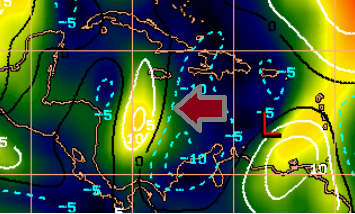
The GFS continues to depict the W Caribbean with generally low shear by Sunday when Isaac or his ghost reaches the area. The 200mb chart shows Isaac will be on the south side of Florences sprawling upper level anticyclone however. So there may be some sinking air for him to deal with that may put a damper on convection. If he can maintain some convection he might be able to carve out his own southern pocket of anticyclonic flow/outflow, perhaps aided by a retrograding upper level low over the GOM.
Also, the "graveyard" idea is that low level flow usually races through the area between Hispaniola and South America, creating relative shear... the W Caribbean has never been known to be part of this "graveyard". Many storms have thrived in that very same area, so take it with a grain of salt. It's all about the setup any given time. Regardless, he will already have traveled past that area by Sunday anyway.
Also, the "graveyard" idea is that low level flow usually races through the area between Hispaniola and South America, creating relative shear... the W Caribbean has never been known to be part of this "graveyard". Many storms have thrived in that very same area, so take it with a grain of salt. It's all about the setup any given time. Regardless, he will already have traveled past that area by Sunday anyway.
1 likes
Re: ATL: ISAAC - Tropical Depression - Discussion
FWIW, grain of salt, etc. The GFS kills him again for the 3rd run at about hour 72ish. His remnants (open wave) continue on to the Yucatan.
1 likes
Personal Forecast Disclaimer:
The posts in this forum are NOT official forecast and should not be used as such. They are just the opinion of the poster and may or may not be backed by sound meteorological data. They are NOT endorsed by any professional institution or storm2k.org. For official information, please refer to the NHC and NWS products.
The posts in this forum are NOT official forecast and should not be used as such. They are just the opinion of the poster and may or may not be backed by sound meteorological data. They are NOT endorsed by any professional institution or storm2k.org. For official information, please refer to the NHC and NWS products.
-
Tampa Bay Hurricane

- Category 5
- Posts: 5597
- Age: 38
- Joined: Fri Jul 22, 2005 7:54 pm
- Location: St. Petersburg, FL
Re: ATL: ISAAC - Tropical Depression - Discussion
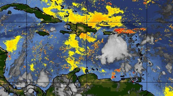
Isaac is really cranking up- lots of convection, not sure if there is an LLC but there is some rotation with areas of strong storms southwest and northeast of center. (Credit goes to Grothar of Weather Underground for the images.)
https://photos.app.goo.gl/7n9iWkKAxKnGgkrx5
https://photos.app.goo.gl/oFwg4RivTedUZUAw6
https://photos.app.goo.gl/7n9iWkKAxKnGgkrx5
https://photos.app.goo.gl/oFwg4RivTedUZUAw6
2 likes
Who is online
Users browsing this forum: No registered users and 48 guests