WPAC: MANGKHUT - Post-Tropical

Moderator: S2k Moderators

Message
Author
User avatar
Highteeld
Category 5
Category 5
Posts: 2139
Age: 41
Joined: Tue Jan 30, 2018 9:10 pm
Location: Chicago

Re: WPAC: MANGKHUT - Typhoon

#681 Postby Highteeld » Fri Sep 14, 2018 12:04 pm

NotoSans wrote:HKO has scheduled to conduct a recon mission on Mangkhut tomorrow.


Interesting. Too bad there wasn't recon in this storm before landfall in Santa Ana. We will get great data from Josh and James, though.
0 likes   
Very useful information on the Dvorak Technique --

https://severe.worldweather.wmo.int/TCF ... kBeven.pdf

User avatar
cycloneye
Admin
Admin
Posts: 145295
Age: 68
Joined: Thu Oct 10, 2002 10:54 am
Location: San Juan, Puerto Rico

Re: WPAC: MANGKHUT - Typhoon

#682 Postby cycloneye » Fri Sep 14, 2018 12:08 pm

0 likes   
Visit the Caribbean-Central America Weather Thread where you can find at first post web cams,radars
and observations from Caribbean basin members Click Here

User avatar
mrbagyo
Category 5
Category 5
Posts: 3715
Age: 33
Joined: Thu Apr 12, 2012 9:18 am
Location: 14.13N 120.98E
Contact:

Re: WPAC: MANGKHUT - Typhoon

#683 Postby mrbagyo » Fri Sep 14, 2018 12:09 pm

Based on latest radar imagery.
Mangkhut appears to be attempting to do an "Eyewall Melding" process
1 likes   
The posts in this forum are NOT official forecast and should not be used as such. They are just the opinion of the poster and may or may not be backed by sound meteorological data. They are NOT endorsed by any professional institution or storm2k.org. For official information, please refer to RSMC, NHC and NWS products.

supercane4867
Category 5
Category 5
Posts: 4966
Joined: Wed Nov 14, 2012 10:43 am

Re: WPAC: MANGKHUT - Typhoon

#684 Postby supercane4867 » Fri Sep 14, 2018 12:13 pm

Definitely still intensifying

Image

Image
1 likes   

User avatar
xtyphooncyclonex
Category 5
Category 5
Posts: 3861
Age: 23
Joined: Sat Dec 08, 2012 9:07 am
Location: Cebu City
Contact:

Re: WPAC: MANGKHUT - Typhoon

#685 Postby xtyphooncyclonex » Fri Sep 14, 2018 12:15 pm

ERC averted. The opposite is basically taking place (?) It's also strengthening even more. This is unlike Megi and Haima. Wow.
0 likes   
REMINDER: My opinions that I, or any other NON Pro-Met in this forum, are unofficial. Please do not take my opinions as an official forecast and warning. I am NOT a meteorologist. Following my forecasts blindly may lead to false alarm, danger and risk if official forecasts from agencies are ignored.

User avatar
Highteeld
Category 5
Category 5
Posts: 2139
Age: 41
Joined: Tue Jan 30, 2018 9:10 pm
Location: Chicago

Re: WPAC: MANGKHUT - Typhoon

#686 Postby Highteeld » Fri Sep 14, 2018 12:16 pm

It's almost like frictional convergence from the slight curvature of the coastline is fusing the two eyewalls into one exceptionally powerful monster.
5 likes   
Very useful information on the Dvorak Technique --

https://severe.worldweather.wmo.int/TCF ... kBeven.pdf

User avatar
mrbagyo
Category 5
Category 5
Posts: 3715
Age: 33
Joined: Thu Apr 12, 2012 9:18 am
Location: 14.13N 120.98E
Contact:

Re: WPAC: MANGKHUT - Typhoon

#687 Postby mrbagyo » Fri Sep 14, 2018 12:20 pm

This typhoon would produce a lot of great case studies
0 likes   
The posts in this forum are NOT official forecast and should not be used as such. They are just the opinion of the poster and may or may not be backed by sound meteorological data. They are NOT endorsed by any professional institution or storm2k.org. For official information, please refer to RSMC, NHC and NWS products.

User avatar
WAcyclone
Category 1
Category 1
Posts: 352
Joined: Sat Jul 01, 2017 1:56 pm
Location: Perth, Western Australia

Re: WPAC: MANGKHUT - Typhoon

#688 Postby WAcyclone » Fri Sep 14, 2018 12:23 pm

53 kt (93 km/h) sustained winds gusting to 79 kt (146 km/h) at Tuguegarao City Airport is the highest I can find so far... Lowest pressure is currently 972 mb. The Buguey station seems to be offline since 1600 UTC.
1 likes   

supercane4867
Category 5
Category 5
Posts: 4966
Joined: Wed Nov 14, 2012 10:43 am

Re: WPAC: MANGKHUT - Typhoon

#689 Postby supercane4867 » Fri Sep 14, 2018 12:25 pm

12z HWRF keeps the inner core intact while crossing the northern tip of Luzon. Possible historic landfall in China

Image

Image
1 likes   

User avatar
mrbagyo
Category 5
Category 5
Posts: 3715
Age: 33
Joined: Thu Apr 12, 2012 9:18 am
Location: 14.13N 120.98E
Contact:

Re: WPAC: MANGKHUT - Typhoon

#690 Postby mrbagyo » Fri Sep 14, 2018 12:33 pm

For the first time in its history, Mangkhut finally got the T 7.0 from ADT 9.0
0 likes   
The posts in this forum are NOT official forecast and should not be used as such. They are just the opinion of the poster and may or may not be backed by sound meteorological data. They are NOT endorsed by any professional institution or storm2k.org. For official information, please refer to RSMC, NHC and NWS products.

NotoSans
Category 5
Category 5
Posts: 1380
Age: 25
Joined: Sun Sep 27, 2015 1:15 am
Location: Toronto
Contact:

Re: WPAC: MANGKHUT - Typhoon

#691 Postby NotoSans » Fri Sep 14, 2018 12:35 pm

Should be the first time since Megi'10 that a typhoon is able to maintain a WMG eye right before making landfall over Luzon. Satellite presentation of Mangkhut looks even stronger than Megi'10 before landfall.
1 likes   
Personal Forecast Disclaimer:
The posts in this forum are NOT official forecast and should not be used as such. They are just the opinion of the poster and may or may not be backed by sound meteorological data. They are NOT endorsed by any professional institution or storm2k.org. For official information, please refer to RSMC and NWS products.

User avatar
mrbagyo
Category 5
Category 5
Posts: 3715
Age: 33
Joined: Thu Apr 12, 2012 9:18 am
Location: 14.13N 120.98E
Contact:

Re: WPAC: MANGKHUT - Typhoon

#692 Postby mrbagyo » Fri Sep 14, 2018 12:39 pm

The radar signature is even more impressive with that thickening Eyewall Ring reminiscent of Hurricane Andrew and Hurricane Irma
2 likes   
The posts in this forum are NOT official forecast and should not be used as such. They are just the opinion of the poster and may or may not be backed by sound meteorological data. They are NOT endorsed by any professional institution or storm2k.org. For official information, please refer to RSMC, NHC and NWS products.

User avatar
mrbagyo
Category 5
Category 5
Posts: 3715
Age: 33
Joined: Thu Apr 12, 2012 9:18 am
Location: 14.13N 120.98E
Contact:

Re: WPAC: MANGKHUT - Typhoon

#693 Postby mrbagyo » Fri Sep 14, 2018 12:43 pm

Is it just me or Mangkhut just did a westward jog.

Close call between Lal-lo and Gonzaga
Last edited by mrbagyo on Fri Sep 14, 2018 12:44 pm, edited 1 time in total.
0 likes   
The posts in this forum are NOT official forecast and should not be used as such. They are just the opinion of the poster and may or may not be backed by sound meteorological data. They are NOT endorsed by any professional institution or storm2k.org. For official information, please refer to RSMC, NHC and NWS products.

User avatar
WAcyclone
Category 1
Category 1
Posts: 352
Joined: Sat Jul 01, 2017 1:56 pm
Location: Perth, Western Australia

Re: WPAC: MANGKHUT - Typhoon

#694 Postby WAcyclone » Fri Sep 14, 2018 12:44 pm

Current radar:

Image
0 likes   

dexterlabio
Category 5
Category 5
Posts: 3468
Joined: Sat Oct 24, 2009 11:50 pm

Re: WPAC: MANGKHUT - Typhoon

#695 Postby dexterlabio » Fri Sep 14, 2018 12:47 pm

Strong winds and rains being felt right now in Katipunan Ave., Quezon City. The wind gusts I saw in Manila area during the passage of Haima in Cagayan were nowhere as strong as this one. Just shows how massive this typhoon is.
1 likes   
Personal Forecast Disclaimer:
The posts in this forum are NOT official forecast and should not be used as such. They are just the opinion of the poster and may or may not be backed by sound meteorological data. They are NOT endorsed by any professional institution or storm2k.org. For official information, please refer to the NHC and NWS products.

User avatar
xtyphooncyclonex
Category 5
Category 5
Posts: 3861
Age: 23
Joined: Sat Dec 08, 2012 9:07 am
Location: Cebu City
Contact:

Re: WPAC: MANGKHUT - Typhoon

#696 Postby xtyphooncyclonex » Fri Sep 14, 2018 12:52 pm

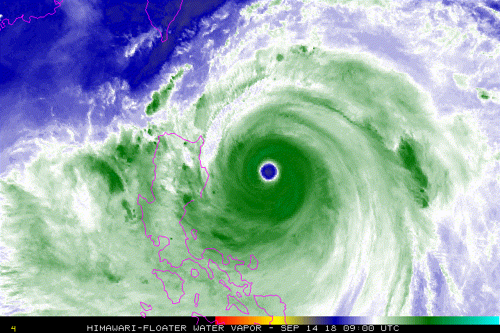
dexterlabio wrote:Strong winds and rains being felt right now in Katipunan Ave., Quezon City. The wind gusts I saw in Manila area during the passage of Haima in Cagayan were nowhere as strong as this one. Just shows how massive this typhoon is.

How much more in Cebu. 91.7 km/h measured. Street lights fell down. Roofs flew away. We're just on the outskirts.
0 likes   
REMINDER: My opinions that I, or any other NON Pro-Met in this forum, are unofficial. Please do not take my opinions as an official forecast and warning. I am NOT a meteorologist. Following my forecasts blindly may lead to false alarm, danger and risk if official forecasts from agencies are ignored.

NotoSans
Category 5
Category 5
Posts: 1380
Age: 25
Joined: Sun Sep 27, 2015 1:15 am
Location: Toronto
Contact:

Re: WPAC: MANGKHUT - Typhoon

#697 Postby NotoSans » Fri Sep 14, 2018 12:56 pm

Global models now show Mangkhut entering the South China Sea as a 930-mb typhoon.
0 likes   
Personal Forecast Disclaimer:
The posts in this forum are NOT official forecast and should not be used as such. They are just the opinion of the poster and may or may not be backed by sound meteorological data. They are NOT endorsed by any professional institution or storm2k.org. For official information, please refer to RSMC and NWS products.

User avatar
Highteeld
Category 5
Category 5
Posts: 2139
Age: 41
Joined: Tue Jan 30, 2018 9:10 pm
Location: Chicago

Re: WPAC: MANGKHUT - Typhoon

#698 Postby Highteeld » Fri Sep 14, 2018 12:57 pm

Image

Perfect CMG ring right at landfall. Well done!
1 likes   
Very useful information on the Dvorak Technique --

https://severe.worldweather.wmo.int/TCF ... kBeven.pdf

User avatar
WAcyclone
Category 1
Category 1
Posts: 352
Joined: Sat Jul 01, 2017 1:56 pm
Location: Perth, Western Australia

Re: WPAC: MANGKHUT - Typhoon

#699 Postby WAcyclone » Fri Sep 14, 2018 12:57 pm

High-resolution radar frame from 15 minutes ago:

 https://twitter.com/dost_pagasa/status/1040660309331996672


Image
2 likes   

User avatar
WAcyclone
Category 1
Category 1
Posts: 352
Joined: Sat Jul 01, 2017 1:56 pm
Location: Perth, Western Australia

Re: WPAC: MANGKHUT - Typhoon

#700 Postby WAcyclone » Fri Sep 14, 2018 1:04 pm

There are quite a few weather stations across the western half of Cagayan but interestingly, Tuguegarao City Airport is still recording the highest winds and the lowest pressure. Conditions as of 1800 UTC: 55 kt (102 km/h) gusting to 94 kt (174 km/h) with a pressure of 962 mb.

Image
2 likes   


Return to “2018”

Who is online

Users browsing this forum: No registered users and 2 guests