


Excessive Rainfall Discussion
NWS Weather Prediction Center College Park MD
1223 PM EDT Fri Sep 21 2018
Day 1
Valid 1622Z Fri Sep 21 2018 - 12Z Sat Sep 22 2018
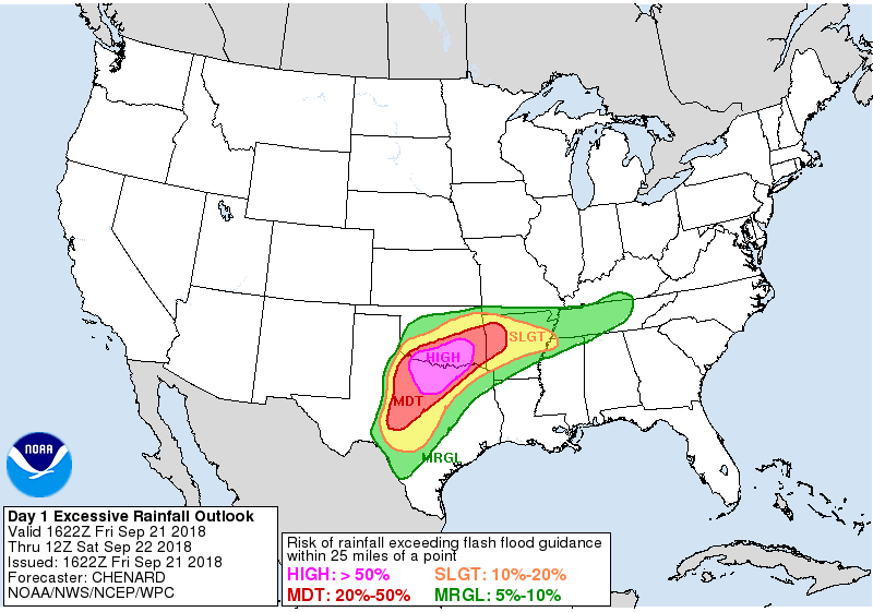
...THERE IS A HIGH RISK OF EXCESSIVE RAINFALL OVER PORTIONS OF THE
SOUTHERN PLAINS...
...Significant and locally life-threatening flash flood event
underway across portions of northern TX and southern OK...
16z Update: Decision was made to upgrade to a HIGH risk of
excessive rainfall across portions of northern TX into southern
OK. Given recent radar trends, observations thus far suggesting
very efficient tropical rainfall processes at play, and 12z
HREF/HRRR guidance...pockets of 6-10" of rain appear likely across
the HIGH risk area today into tonight. The highest threat is
focused along and south of the nearly stationary west to east
convective line stretching across southern OK as of 16z. Expect
convection to continue to develop into this boundary from the
south as the low over west TX slowly pushes east. Convection will
eventually expand southward into north TX ahead of this low...with
slow moving/training likely here as well as we head through the
day into tonight. See the latest MPD for the most up to date
information. -Chenard
NWS Weather Prediction Center College Park MD
1223 PM EDT Fri Sep 21 2018
Day 1
Valid 1622Z Fri Sep 21 2018 - 12Z Sat Sep 22 2018
...THERE IS A HIGH RISK OF EXCESSIVE RAINFALL OVER PORTIONS OF THE
SOUTHERN PLAINS...
...Significant and locally life-threatening flash flood event
underway across portions of northern TX and southern OK...
16z Update: Decision was made to upgrade to a HIGH risk of
excessive rainfall across portions of northern TX into southern
OK. Given recent radar trends, observations thus far suggesting
very efficient tropical rainfall processes at play, and 12z
HREF/HRRR guidance...pockets of 6-10" of rain appear likely across
the HIGH risk area today into tonight. The highest threat is
focused along and south of the nearly stationary west to east
convective line stretching across southern OK as of 16z. Expect
convection to continue to develop into this boundary from the
south as the low over west TX slowly pushes east. Convection will
eventually expand southward into north TX ahead of this low...with
slow moving/training likely here as well as we head through the
day into tonight. See the latest MPD for the most up to date
information. -Chenard


 ridiculous rates
