
A really interesting and challenging project to take on and one that I think you'll find with time will be complimented by data and input by a number of others during the "off season". Given the limited time everyone has in conjunction with a plateful of current forum threads, I think many will eventually take the time to resurrect your post and add a good deal of addition great discussion.
Post analysis including comparisons of tree and overall foliage damage offers us tremendous insight to the destructive nature and large scale impact resulting from strong tropical cyclone landfall events. Drawing intensity comparison however seems pretty daunting given the multitude of variables involved (type's of tree's, storm wind-field, wind trajectory and hours of impact, overall topography, storm surge and other storm exacerbated impact, etc.) but I realize those observations are not being ignored with some having already been briefly considered.
A couple of quick thoughts (possibly already addressed in some of the above individual event analysis) that immediately occurred to me include the differential impact as a result of up-slope (topographical impact) terrain highlighted during some infamous Island landfall events. Obviously, some level of wind forcing or added vertical affect is further exhibited during those landfall events that may not be as similarly duplicated in flat terrain landfall events. Another curious thought is what greater twisting damage might have occurred during very small intense storms such as Andrew, as compared to far larger wind-field land-falling hurricanes where effects may appear characterized by more straight-line appearance? Finally, one additional variable which certainly might affect how severe tree damage might be perceived or compared in the future is the degree (and strength of structure) due to a particular regions' urbanization and type's of construction. Assuming outside of storm surge inundation, urbanized regions exhibiting large strongly built structures (especially those built to code) may well shield tree's and other vegetation at least closely to ground level. I only make that point when attempting to compare the distinction of lesser "wind-barrier" impact to those area's where a good deal more modern construction may be more common as compared to "greener" less urban more natural Island habitats.
Tree Damage in Intense Landfalling Hurricanes of the Past
Moderator: S2k Moderators
Forum rules

The posts in this forum are NOT official forecasts and should not be used as such. They are just the opinion of the poster and may or may not be backed by sound meteorological data. They are NOT endorsed by any professional institution or STORM2K. For official information, please refer to products from the National Hurricane Center and National Weather Service.
Re: Tree Damage in Intense Landfalling Hurricanes of the Past
3 likes
Andy D
(For official information, please refer to the NHC and NWS products.)
(For official information, please refer to the NHC and NWS products.)
Re: Tree Damage in Intense Landfalling Hurricanes of the Past
Another storm you may want to consider adding is Hurricane Mitch of 1998. He's famous for the massive flooding he caused and the resulting large number of casualties, but before landfall in Honduras, the island of Guanaja off the coast of Honduras took a direct hit while Mitch was close to his peak intensity from what I can tell.
He destroyed almost the entire population of red mangrove trees, uprooting or knocking down most of them, and the ones that were left standing took so much internal damage they couldn't regrow. 70% of conifer trees were knocked down, and all trees were stripped of their leaves. Apparently the island was subjected to 2 days worth of winds exceeding 120mph.
Links to photos:
https://goo.gl/images/RfvgW6
https://goo.gl/images/dgPVsu
https://goo.gl/images/PDXWku
https://goo.gl/images/oH8A1n
2 likes
Solar Aquarian
Lunar Cancerian
 Sagittarian
Lunar Cancerian
-
mrbagyo

- Category 5

- Posts: 3990
- Age: 33
- Joined: Thu Apr 12, 2012 9:18 am
- Location: 14.13N 120.98E
- Contact:
Re: Tree Damage in Intense Landfalling Hurricanes of the Past
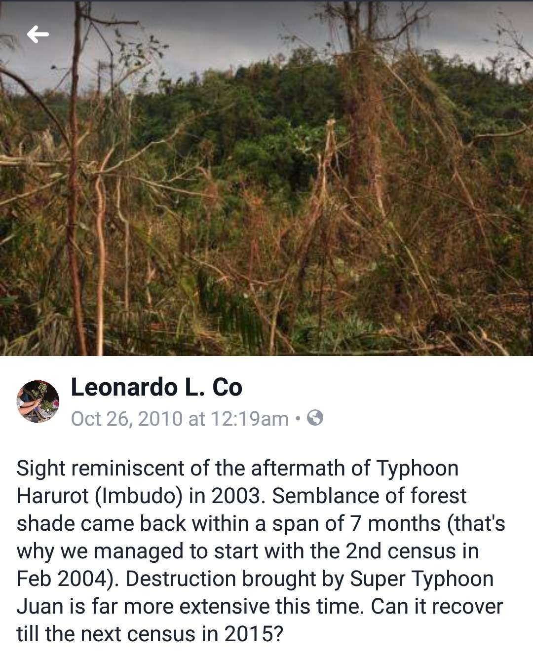
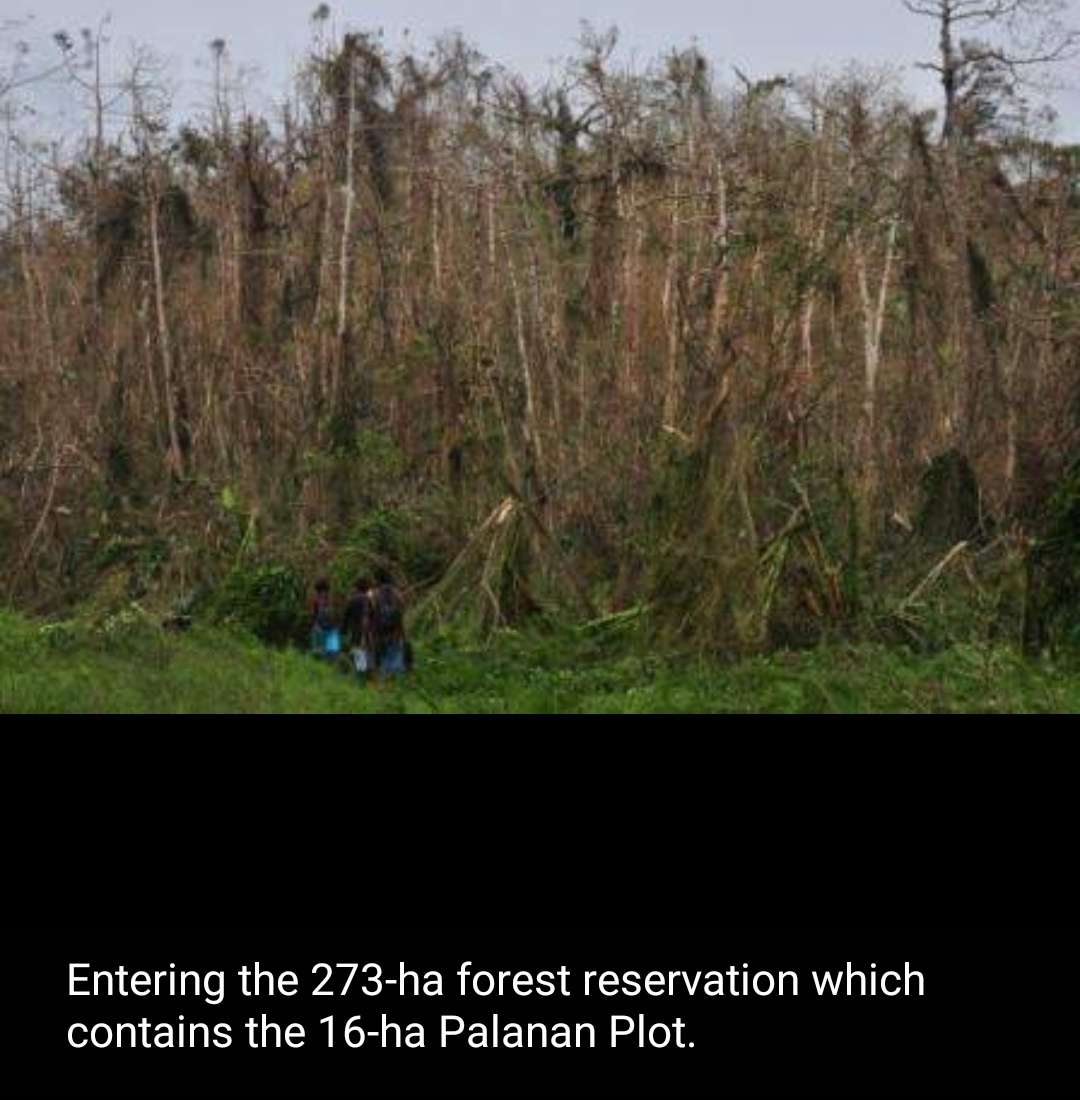
Just want to drop some of the rare images of Tree damage from Typhoon Megi in Isabela Province in the Northern Sierra Madre, Luzon -
https://imageshack.com/a/img923/7189/VqhpAb.jpg
https://imageshack.com/a/img924/6531/ds9MN4.jpg
https://imageshack.com/a/img923/1194/79MDjt.jpg
https://imageshack.com/a/img923/8949/iXWCac.jpg
You'll notice in the above photos that the vegetation damage wasn't that extreme as one would expect from a Cat 5 landfall- maybe that's because the photos were taken in Palanan (which is located in the weaker southern Eyewall or maybe the trees just evolved to be so freakin resilient/tough).
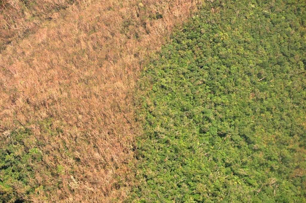
This photo is an exception though - which was probably taken somewhere above the Sierra Madre north of Palanan (maybe in Divilacan or Maconacon ), notice the dramatic demarcation line
all photos were taken by the late Filipino Botanist Leonard Co who experienced Megi firsthand in Palanan, Isabela (I won't be surprised if he was also there in 1998 during Super Typhoon Zeb).
https://imageshack.com/a/img923/7189/VqhpAb.jpg
https://imageshack.com/a/img924/6531/ds9MN4.jpg
https://imageshack.com/a/img923/1194/79MDjt.jpg
https://imageshack.com/a/img923/8949/iXWCac.jpg
You'll notice in the above photos that the vegetation damage wasn't that extreme as one would expect from a Cat 5 landfall- maybe that's because the photos were taken in Palanan (which is located in the weaker southern Eyewall or maybe the trees just evolved to be so freakin resilient/tough).
This photo is an exception though - which was probably taken somewhere above the Sierra Madre north of Palanan (maybe in Divilacan or Maconacon ), notice the dramatic demarcation line
all photos were taken by the late Filipino Botanist Leonard Co who experienced Megi firsthand in Palanan, Isabela (I won't be surprised if he was also there in 1998 during Super Typhoon Zeb).
4 likes
The posts in this forum are NOT official forecast and should not be used as such. They are just the opinion of the poster and may or may not be backed by sound meteorological data. They are NOT endorsed by any professional institution or storm2k.org. For official information, please refer to RSMC, NHC and NWS products.
-
wxmann_91

- Category 5
- Posts: 8007
- Age: 34
- Joined: Fri Jul 15, 2005 2:49 pm
- Location: Southern California
- Contact:
Re: Tree Damage in Intense Landfalling Hurricanes of the Past
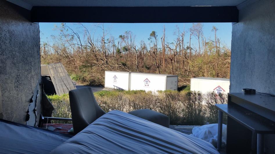
Now that Michael is in the books I think it is worthy of comparison to the other great ones in this thread.
Extreme damage of pine trees was noted by Mark Sudduth (hurricanetrack).
Trees denuded and snapped near Panama City.
The tree damage could even be seen in space.
Extreme damage of pine trees was noted by Mark Sudduth (hurricanetrack).
Trees denuded and snapped near Panama City.
The tree damage could even be seen in space.
6 likes
-
supercane4867
- Category 5
- Posts: 4966
- Joined: Wed Nov 14, 2012 10:43 am
Re: Tree Damage in Intense Landfalling Hurricanes of the Past
Michael's destruction to forests reminds me of scenes from 2011 tornado outbreak
https://twitter.com/aaronjayjack/status/1050514866895814659
https://twitter.com/weatherdak/status/1050571101909049344
https://twitter.com/aaronjayjack/status/1050514866895814659
https://twitter.com/weatherdak/status/1050571101909049344
4 likes
-
tolakram
- Admin

- Posts: 20186
- Age: 62
- Joined: Sun Aug 27, 2006 8:23 pm
- Location: Florence, KY (name is Mark)
Re: Tree Damage in Intense Landfalling Hurricanes of the Past
What an incredibly well timed thread, including the discussion of Camille. If Camille was going through an ERC this would explain why damage was as bad as it was with the wind and surge spread out. With Michael we see a high end cat 4 (I believe 5) and the extreme wind damage in a more narrow area. The tree damage alone scream cat 5 to me, but then I'm not qualified to judge wind speed from damage.
6 likes
M a r k
- - - - -
Join us in chat: Storm2K Chatroom Invite. Android and IOS apps also available.
The posts in this forum are NOT official forecasts and should not be used as such. Posts are NOT endorsed by any professional institution or STORM2K.org. For official information and forecasts, please refer to NHC and NWS products.
-
EquusStorm
- Category 5
- Posts: 1649
- Age: 35
- Joined: Thu Nov 07, 2013 1:04 pm
- Location: Jasper, AL
- Contact:
Re: Tree Damage in Intense Landfalling Hurricanes of the Past
Wow so much great discussion, contributions, and content! I am thrilled!
@ chaser1 Very very good points and observations, I agree. It's not going to be a perfect or easy task for sure and there are an absurd amount of variables that will prevent perfect accuracy; but it's still pretty neat to compare even though there are tremendous differences around the world with tree types, topography, etc. Definitely a lot of things to consider and discuss.
@ Chris90 Ah, I actually did not know Mitch affected an island during its offshore stall! Very interesting! Will certainly have to be added. Thanks!
@ mrbagyo Rare and fascinating photos - thank you very much for sharing! Am really appreciative of more WPac documentation, I could not find very much with basic web searches.
@ wxmann_91 No doubt - I am still reeling that Michael was a thing that actually happened. Some of the worst tree damage ever seen in the mainland US without a doubt. Will certainly add Michael and many more soon.
@ supercane4867 Yeah, my thoughts when watching the Tyndall AFB flyover shifted quickly to "this reminds me of Tuscaloosa" when the shredded remnants of trees showed up in frame. It's chilling. Basically a 40 or 50 mile wide EF2-3 tornado that lasts an hour. Can't begin to fathom it. The degree of inland penetration of high-end completely forest leveling winds is just unreal.
@ tolakram I swear I had no idea Michael was going to happen when I made this thread, lmao. Timing, indeed. I guess it was Camille discussions that led to looking into this. There's pretty good photo-documentation for Camille given that cameras weren't as ubiqtuous in 1969 as in later decades but I still wish there was even more. I've seen a crude radar loop of Camille's landfall and it looks like the southern eyewall had opened up in an ERC, probably before having any intensity effect, but that could very easily be an artifact of the more primitive radar at the time rather than an actual gap in high eyewall returns. It would help explain a larger wind field to enhance the insane surge, though.
@ chaser1 Very very good points and observations, I agree. It's not going to be a perfect or easy task for sure and there are an absurd amount of variables that will prevent perfect accuracy; but it's still pretty neat to compare even though there are tremendous differences around the world with tree types, topography, etc. Definitely a lot of things to consider and discuss.
@ Chris90 Ah, I actually did not know Mitch affected an island during its offshore stall! Very interesting! Will certainly have to be added. Thanks!
@ mrbagyo Rare and fascinating photos - thank you very much for sharing! Am really appreciative of more WPac documentation, I could not find very much with basic web searches.
@ wxmann_91 No doubt - I am still reeling that Michael was a thing that actually happened. Some of the worst tree damage ever seen in the mainland US without a doubt. Will certainly add Michael and many more soon.
@ supercane4867 Yeah, my thoughts when watching the Tyndall AFB flyover shifted quickly to "this reminds me of Tuscaloosa" when the shredded remnants of trees showed up in frame. It's chilling. Basically a 40 or 50 mile wide EF2-3 tornado that lasts an hour. Can't begin to fathom it. The degree of inland penetration of high-end completely forest leveling winds is just unreal.
@ tolakram I swear I had no idea Michael was going to happen when I made this thread, lmao. Timing, indeed.
6 likes
Colors of lost purpose on the canvas of irrelevance
Not a meteorologist, in fact more of an idiot than anything. You should probably check with the NHC or a local NWS office for official information.
Not a meteorologist, in fact more of an idiot than anything. You should probably check with the NHC or a local NWS office for official information.
-
mrbagyo
- Category 5
- Posts: 3990
- Age: 33
- Joined: Thu Apr 12, 2012 9:18 am
- Location: 14.13N 120.98E
- Contact:
Re: Tree Damage in Intense Landfalling Hurricanes of the Past
Can we extrapolate or compute the wind load requirement / force needed to snap a certain tree species based on its green (because the tree is still alive) MOR or Modulus of Rapture, tree Height, trunk width?
I think MOR of pines typically range from 50 to 100 MPa (plantation trees tend to be lower though).
Palms are about 80 MPa but could be even higher depending on age (it's a monocot, the strongest part is on the outer part not on the inside)
Hardwood trees typically have values ranging from 80 to 200 MPa ( though some can be lower that softwood trees like balsa).
Last edited by mrbagyo on Fri Oct 12, 2018 8:11 pm, edited 1 time in total.
1 likes
The posts in this forum are NOT official forecast and should not be used as such. They are just the opinion of the poster and may or may not be backed by sound meteorological data. They are NOT endorsed by any professional institution or storm2k.org. For official information, please refer to RSMC, NHC and NWS products.

Re: Tree Damage in Intense Landfalling Hurricanes of the Past
Debarking of pines from Michael. Image from iCyclone.
1 likes
Kendall -> SLO -> PBC
Memorable Storms: Katrina (for its Florida landfall...) Wilma Matthew Irma
Memorable Storms: Katrina (for its Florida landfall...) Wilma Matthew Irma
-
mrbagyo
- Category 5
- Posts: 3990
- Age: 33
- Joined: Thu Apr 12, 2012 9:18 am
- Location: 14.13N 120.98E
- Contact:
Re: Tree Damage in Intense Landfalling Hurricanes of the Past
Typhoon Bopha (December 2012) in Baganga & Cateel, Davao Oriental.
 Coconut tree snapped at the trunk
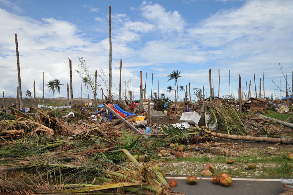
More snapped Coconut trees
Punctured Coconut tree
Coconut tree snapped at the trunkMore snapped Coconut trees
Punctured Coconut tree
2 likes
The posts in this forum are NOT official forecast and should not be used as such. They are just the opinion of the poster and may or may not be backed by sound meteorological data. They are NOT endorsed by any professional institution or storm2k.org. For official information, please refer to RSMC, NHC and NWS products.


Re: Tree Damage in Intense Landfalling Hurricanes of the Past
HURRICANE FREDERIC: I can vividly recall driving through miles & miles of pines either snapped or bent over to the ground driving from MS to Mobile. It was not as bad as Michael or Camille, IMHO, but pretty amazing considering it was not as remarkable as the others on your list.
1 likes
-
galaxy401

- Category 5
- Posts: 2446
- Age: 30
- Joined: Sat Aug 25, 2012 9:04 pm
- Location: Casa Grande, Arizona
Re: Tree Damage in Intense Landfalling Hurricanes of the Past
Well now we have a new Category 5 landfall with Dorian in the northern Bahamas. Some photos are coming in of the destruction and that includes the trees. Heard some palm trees got completely uprooted.
Some pictures I found on Discord and Twitter. Granted, I don't know if they're 100% reliable but the actual damage should be similar.

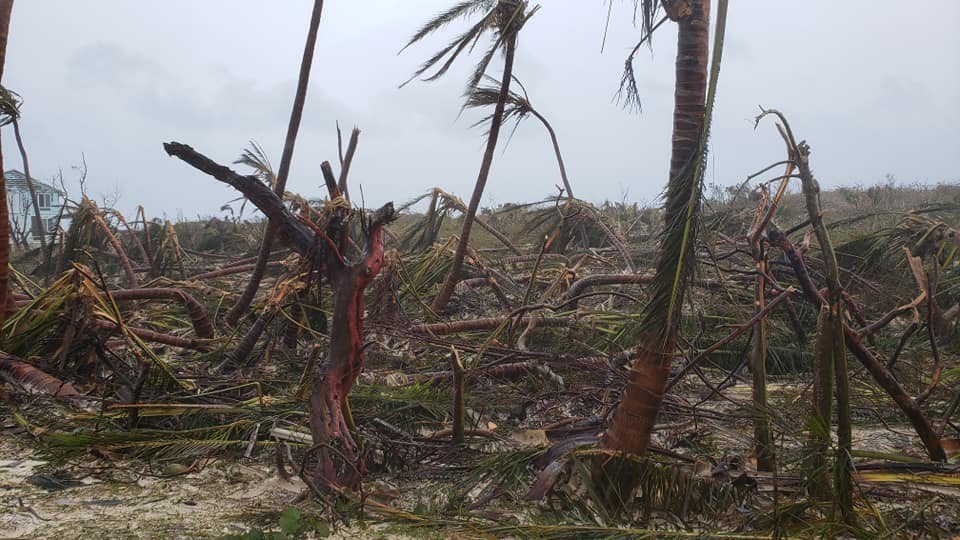
Obivously this is still an ongoing process so we'll get more photos of the damage in the coming weeks.
Some pictures I found on Discord and Twitter. Granted, I don't know if they're 100% reliable but the actual damage should be similar.
Obivously this is still an ongoing process so we'll get more photos of the damage in the coming weeks.
0 likes
Got my eyes on moving right into Hurricane Alley: Florida.
-
Audrey2Katrina

- Category 5
- Posts: 4252
- Age: 76
- Joined: Fri Dec 23, 2005 10:39 pm
- Location: Metaire, La.
Re: Tree Damage in Intense Landfalling Hurricanes of the Past
EquusStorm wrote:I won't argue with experts on Camille's intensity, as I have no legitimate claim to know any better than them, but I really do wish photo-documentation was better; that I haven't ever found any photos suggesting anything over 130-140mph doesn't mean the photos don't exist, or it could easily mean that the worst was simply not photographed. Documentation in the 60s is honestly pretty iffy even in the US. I would certainly believe that there was a super narrow corridor of extreme winds in the eastern eyewall, being an extremely tightly wound storm, but I have yet to find any photos from this area, which would have undoubtedly been hard to access from all the damage TO be able to take photos. Deep surge would probably indeed keep trees from snapping down low but 160mph+ winds easily shred and debark all of the above-water exposed portions of softwoods and this isn't evident in any available photos I've seen; I would LOVE to find some photos from where the eastern eyewall came ashore though! If anyone finds some PLEASE share them because I'd love to compare 160-175mph tree damage in Mississippi with similar winds in the deep tropics. All of the photos I have found are based on structural and tree damage seem to be in the 100-140mph zone probably east of the eyewall.
I can't provide any photographs, because I was just at 20 when Camille hit, and I can assure you I saw mile after mile of trees snapped like toothpicks. I lived in New Orleans at the time and from what I understand Camille had a very narrow diameter of hurricane force winds. I was with a volunteer group that drove into Mississippi for rescue and cleanup after that storm, and I was absolutely stunned at the miles of snapped pines I saw driving into the area we worked. I lived it, I saw it, and it made a permanent impression on me-- Camille was no fluke it was every bit of a 5 and while trees "can" be a decent indicator of damage, I feel that in areas where surge coming in can actually skew the results.. same goes for structural damage, and the landfall area of where Camille hit was totally devastated. With all due respect, I have to disagree with your assessment; but that's what makes the forum interesting. That said, I find eye-witness accounts who actually were there and were able to cover huge areas of the catastrophe first hand a little more reliable than photos of trees or even structures taken from one or another vantage point. They can help -- but they can't be the sole basis of evaluation. I will never forget that trip into Mississippi. Thanks!
.
A2K
1 likes
Flossy 56 Audrey 57 Hilda 64* Betsy 65* Camille 69* Edith 71 Carmen 74 Bob 79 Danny 85 Elena 85 Juan 85 Florence 88 Andrew 92*, Opal 95, Danny 97, Georges 98*, Isidore 02, Lili 02, Ivan 04, Cindy 05*, Dennis 05, Katrina 05*, Gustav 08*, Isaac 12*, Nate 17, Barry 19, Cristobal 20, Marco, 20, Sally, 20, Zeta 20*, Claudette 21 IDA* 21 Francine *24
-
EquusStorm
- Category 5
- Posts: 1649
- Age: 35
- Joined: Thu Nov 07, 2013 1:04 pm
- Location: Jasper, AL
- Contact:
Re: Tree Damage in Intense Landfalling Hurricanes of the Past
Audrey2Katrina wrote:I can't provide any photographs, because I was just at 20 when Camille hit, and I can assure you I saw mile after mile of trees snapped like toothpicks. I lived in New Orleans at the time and from what I understand Camille had a very narrow diameter of hurricane force winds. I was with a volunteer group that drove into Mississippi for rescue and cleanup after that storm, and I was absolutely stunned at the miles of snapped pines I saw driving into the area we worked. I lived it, I saw it, and it made a permanent impression on me-- Camille was no fluke it was every bit of a 5 and while trees "can" be a decent indicator of damage, I feel that in areas where surge coming in can actually skew the results.. same goes for structural damage, and the landfall area of where Camille hit was totally devastated. With all due respect, I have to disagree with your assessment; but that's what makes the forum interesting. That said, I find eye-witness accounts who actually were there and were able to cover huge areas of the catastrophe first hand a little more reliable than photos of trees or even structures taken from one or another vantage point. They can help -- but they can't be the sole basis of evaluation. I will never forget that trip into Mississippi. Thanks!
.
A2K
A report like that makes me a lot more confident in Camille's extreme winds; I assumed there could have been an area of high end tree damage that just wasn't photographed so that definitely makes sense and it's good to have a first hand report that confirms this. No doubt the surge impact probably also made the tree and structural damage aspect very complicated as well. It's hard to make an accurate assessment based on an incomplete photographic record on a storm that hit two decades before I was born lol.
1 likes
Colors of lost purpose on the canvas of irrelevance
Not a meteorologist, in fact more of an idiot than anything. You should probably check with the NHC or a local NWS office for official information.
Not a meteorologist, in fact more of an idiot than anything. You should probably check with the NHC or a local NWS office for official information.
-
EquusStorm
- Category 5
- Posts: 1649
- Age: 35
- Joined: Thu Nov 07, 2013 1:04 pm
- Location: Jasper, AL
- Contact:
Re: Tree Damage in Intense Landfalling Hurricanes of the Past
Well since compiling this list and mentioning it's hard to compare subtropical pine forest damage a la Hugo and Camille without as much modern high def photo analysis as we get in the new millennium, Michael, Dorian, and Laura have happened, so it's probably time for an update lol
3 likes
Colors of lost purpose on the canvas of irrelevance
Not a meteorologist, in fact more of an idiot than anything. You should probably check with the NHC or a local NWS office for official information.
Not a meteorologist, in fact more of an idiot than anything. You should probably check with the NHC or a local NWS office for official information.
Re: Tree Damage in Intense Landfalling Hurricanes of the Past
I can say that from my Andrew experience, there were many lots with trees (mostly pines) in South Dade that resembled toothpicks even into the early 2000s. I can't recall if they were debarked or stripped, but they looked petrified in the sense that they were permanently just ruined.
1 likes
Andrew (1992), Irene (1999), Frances (2004), Katrina (2005), Wilma (2005), Fay (2008), Irma (2017), Eta (2020), Ian (2022)
-
HurricaneEnzo

- Category 2

- Posts: 744
- Joined: Wed Mar 14, 2018 12:18 pm
- Location: Newport, NC (Hurricane Alley)
Re: Tree Damage in Intense Landfalling Hurricanes of the Past
This doesn't really fit the OP exactly but thought I would share. I can say the worst tree damage I have ever seen in the area I live was from Cat 1 Hurricane Florence. The combination of long duration winds and near 30 inches of rain caused absolute devastation. I have never seen so many uprooted and snapped off trees. I have probably experienced close to a dozen Hurricanes in my lifetime (some more powerful) and none of the others came remotely close.
Sent from my SM-N986U1 using Tapatalk
Sent from my SM-N986U1 using Tapatalk
3 likes
Bertha 96' - Fran 96' - Bonnie 98' - Dennis 99' - Floyd 99' - Isabel 03' - Alex 04' - Ophelia 05' - Irene 11' - Arthur 14' - Matthew 16' - Florence 18' - Dorian 19' - Isaias 20' (countless other tropical storms and Hurricane swipes)
I am not a Professional Met just an enthusiast. Get your weather forecasts from the Pros!
I am not a Professional Met just an enthusiast. Get your weather forecasts from the Pros!
-
tarheelprogrammer

- S2K Supporter

- Posts: 1793
- Joined: Mon Mar 28, 2016 9:25 pm
- Location: Raleigh, NC area (Garner, NC)
Re: Tree Damage in Intense Landfalling Hurricanes of the Past
HurricaneEnzo wrote:This doesn't really fit the OP exactly but thought I would share. I can say the worst tree damage I have ever seen in the area I live was from Cat 1 Hurricane Florence. The combination of long duration winds and near 30 inches of rain caused absolute devastation. I have never seen so many uprooted and snapped off trees. I have probably experienced close to a dozen Hurricanes in my lifetime (some more powerful) and none of the others came remotely close.
Sent from my SM-N986U1 using Tapatalk
Agreed, we came back to Southport, NC about 5 days after the storm and it looked apocalyptic. Worst damage I have seen in my life living in NC. ABSOLUTE DEVASTATION. Lots of homes flooded with their stuff at the road
2 likes
My posts are not official forecasts. They are just my opinion and may or may not be backed by sound meteorological data. They are NOT endorsed by any professional institution or storm2k.org. For official information, please refer to the NHC and NWS products.
-
Shell Mound
- Category 5
- Posts: 2432
- Age: 33
- Joined: Thu Sep 07, 2017 3:39 pm
- Location: St. Petersburg, FL → Scandinavia
Re: Tree Damage in Intense Landfalling Hurricanes of the Past
https://twitter.com/BFMTV/status/1299212819099983872
https://twitter.com/meteo60/status/1299244062311153666
https://twitter.com/CirculoGloBal_I/status/1299164733510217730
https://twitter.com/meteo60/status/1299244062311153666
https://twitter.com/CirculoGloBal_I/status/1299164733510217730
0 likes
CVW / MiamiensisWx / Shell Mound
The posts in this forum are NOT official forecasts and should not be used as such. They are just the opinion of the poster and may or may not be backed by sound meteorological data. They are NOT endorsed by any professional institution or STORM2K. For official information, please refer to products from the NHC and NWS.
-
SootyTern
- S2K Supporter
- Posts: 316
- Age: 57
- Joined: Sun Sep 05, 2004 5:09 pm
- Location: NYC (formerly Homestead, FL)
Re: Tree Damage in Intense Landfalling Hurricanes of the Past
The tree damage in those photos from Cameron looks more like Cat. 2 or 3. Most of those big trees are probably live oaks; they should've shedded all of their smaller branches with just the very largest boughs remaining (the basic structure of the tree) if the winds were 4 or 5. Can see a lot of variation in the outcome for the buildings based on construction; some of those larger buildings look pretty solid.
2 likes
Disclaimer:
The posts in this forum are NOT official forecasts and should not be used as such. For official information, please refer to the NHC and NWS products.
Gulf Coast: Opal '95 Georges '98 / So Fla: Katrina '05 Wilma '05 Irma '17
The posts in this forum are NOT official forecasts and should not be used as such. For official information, please refer to the NHC and NWS products.
Gulf Coast: Opal '95 Georges '98 / So Fla: Katrina '05 Wilma '05 Irma '17
Who is online
Users browsing this forum: Bing [Bot] and 237 guests