ATL: INVEST 98L - Discussion
Moderator: S2k Moderators

Re: ATL: INVEST 98L - Discussion
Recon have the center about 33.483N 76.417W
0 likes
Personal Forecast Disclaimer:
The posts in this forum are NOT official forecast and should not be used as such. They are just the opinion of the poster and may or may not be backed by sound meteorological data. They are NOT endorsed by any professional institution or storm2k.org. For official information, please refer to the NHC and NWS products.
The posts in this forum are NOT official forecast and should not be used as such. They are just the opinion of the poster and may or may not be backed by sound meteorological data. They are NOT endorsed by any professional institution or storm2k.org. For official information, please refer to the NHC and NWS products.
-
Aric Dunn
- Category 5

- Posts: 21238
- Age: 43
- Joined: Sun Sep 19, 2004 9:58 pm
- Location: Ready for the Chase.
- Contact:
Re: ATL: INVEST 98L - Discussion
Airboy wrote:Recon have the center about 33.483N 76.417W
they were not fully at operational altitude at that time. was a wind switch from dropping down more.
they are down in the general area now. straight south winds means the center is ever so slightly to the west.
0 likes
Note: If I make a post that is brief. Please refer back to previous posts for the analysis or reasoning. I do not re-write/qoute what my initial post said each time.
If there is nothing before... then just ask
Space & Atmospheric Physicist, Embry-Riddle Aeronautical University,
I believe the sky is falling...
If there is nothing before... then just ask
Space & Atmospheric Physicist, Embry-Riddle Aeronautical University,
I believe the sky is falling...

Re: ATL: INVEST 98L - Discussion
Recon reported a west wind flying at 981mb (altitude 1000 ft)
0 likes
Re: ATL: INVEST 98L - Discussion
Aric Dunn wrote:Airboy wrote:Recon have the center about 33.483N 76.417W
they were not fully at operational altitude at that time. was a wind switch from dropping down more.
they are down in the general area now. straight south winds means the center is ever so slightly to the west.
oh okey, yeah, I see that they maybe found a center more SE of it
0 likes
Personal Forecast Disclaimer:
The posts in this forum are NOT official forecast and should not be used as such. They are just the opinion of the poster and may or may not be backed by sound meteorological data. They are NOT endorsed by any professional institution or storm2k.org. For official information, please refer to the NHC and NWS products.
The posts in this forum are NOT official forecast and should not be used as such. They are just the opinion of the poster and may or may not be backed by sound meteorological data. They are NOT endorsed by any professional institution or storm2k.org. For official information, please refer to the NHC and NWS products.
-
Sciencerocks
- Category 5
- Posts: 10181
- Age: 40
- Joined: Thu Jul 06, 2017 1:51 am
Re: ATL: INVEST 98L - Discussion
I don't know what happened with that thread posting. lol
Anyways here a image of the recon
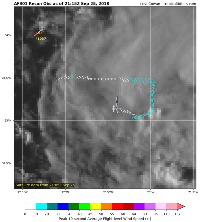
Anyways here a image of the recon
0 likes
-
Aric Dunn
- Category 5
- Posts: 21238
- Age: 43
- Joined: Sun Sep 19, 2004 9:58 pm
- Location: Ready for the Chase.
- Contact:
Re: ATL: INVEST 98L - Discussion
Solid center fix from recon.
33.16N 76.09W
vs mine from an hour ago..
33.12N 75.9W
33.16N 76.09W
vs mine from an hour ago..
33.12N 75.9W
1 likes
Note: If I make a post that is brief. Please refer back to previous posts for the analysis or reasoning. I do not re-write/qoute what my initial post said each time.
If there is nothing before... then just ask
Space & Atmospheric Physicist, Embry-Riddle Aeronautical University,
I believe the sky is falling...
If there is nothing before... then just ask
Space & Atmospheric Physicist, Embry-Riddle Aeronautical University,
I believe the sky is falling...
-
cycloneye

- Admin

- Posts: 149276
- Age: 69
- Joined: Thu Oct 10, 2002 10:54 am
- Location: San Juan, Puerto Rico
Re: ATL: INVEST 98L - Discussion
Sciencerocks wrote:I don't know what happened with that thread posting. lol
Anyways here a image of the recon
https://imageshack.com/a/img923/5656/lt2Wtz.png
I moved it to the 98L recon thread.
1 likes
Visit the Caribbean-Central America Weather Thread where you can find at first post web cams,radars
and observations from Caribbean basin members Click Here
and observations from Caribbean basin members Click Here
-
BensonTCwatcher

- Category 5
- Posts: 1050
- Joined: Sat Aug 28, 2004 10:11 pm
- Location: Southport NC
Re: ATL: INVEST 98L - Discussion
Thankfully this cannot get the convection to sustain , although it has been firing all around the center and glad it's short on time to encounter shear to the NW of the system. Hope it stays that way overnight tonight. In reality that's a good bit of time to allow for beach erosion on already hammered beaches.
0 likes

Re: ATL: INVEST 98L - Discussion
Looks like we're going to come down to a judgement call by whoever is on shift. Hopefully we can get an upgrade out of this so that (as with TD10) it can go on official record.
1 likes
The above post is not official and should not be used as such. It is the opinion of the poster and may or may not be backed by sound meteorological data. It is not endorsed by any professional institution or storm2k.org. For official information, please refer to the NHC and NWS products.
-
EquusStorm
- Category 5
- Posts: 1649
- Age: 35
- Joined: Thu Nov 07, 2013 1:04 pm
- Location: Jasper, AL
- Contact:
Re: ATL: INVEST 98L - Discussion
That's the thing that frustrates me. Having this fascinating long lived feature, worthy of being labeled a depression it seems, documented at all comes down to a subjective judgment call. If they don't upgrade, this goes down as nothing in the books. If there's a closed center (seems to nearly be as per recon) and deep convection (has been for 2 days) it's a tropical depression. They've initiated advisories on much worse lol
0 likes
Colors of lost purpose on the canvas of irrelevance
Not a meteorologist, in fact more of an idiot than anything. You should probably check with the NHC or a local NWS office for official information.
Not a meteorologist, in fact more of an idiot than anything. You should probably check with the NHC or a local NWS office for official information.
-
seahawkjd
- S2K Supporter

- Posts: 632
- Joined: Wed Sep 10, 2003 4:12 pm
- Location: Morehead City, NC
- Contact:
Re: ATL: INVEST 98L - Discussion
Is it possible they won't do it so that they don't freak out coastal NC? Its close but it doesn't seem like its going to do much (it did quite enough the first time around  )
)
0 likes
Gloria, Hugo, Emily, Bertha, Bonnie, Dennis (twice), Fran, Floyd, Isabel, Irene, Arthur, Matthew, Florence, Dorian (and many tropical storms and nor'easters).
-
Aric Dunn
- Category 5
- Posts: 21238
- Age: 43
- Joined: Sun Sep 19, 2004 9:58 pm
- Location: Ready for the Chase.
- Contact:
Re: ATL: INVEST 98L - Discussion
THe first spiral band is developing on radar. starting to organize even more.
0 likes
Note: If I make a post that is brief. Please refer back to previous posts for the analysis or reasoning. I do not re-write/qoute what my initial post said each time.
If there is nothing before... then just ask
Space & Atmospheric Physicist, Embry-Riddle Aeronautical University,
I believe the sky is falling...
If there is nothing before... then just ask
Space & Atmospheric Physicist, Embry-Riddle Aeronautical University,
I believe the sky is falling...
Re: ATL: INVEST 98L - Discussion
Product: Air Force Vortex Message (URNT12 KNHC)
Transmitted: 25th day of the month at 22:11Z
Agency: United States Air Force
Aircraft: Lockheed WC-130J Hercules with reg. number AF96-5301
Mission Purpose: Investigate second suspect area (flight in the North Atlantic basin)
Mission Number: 1
Observation Number: 09 ( See all messages of this type for this mission. )
A. Time of Center Fix: 25th day of the month at 21:41:00Z
B. Center Fix Coordinates: 33.27N 76.12W
B. Center Fix Location: 107 statute miles (172 km) to the SSE (160°) from Morehead City, NC, USA.
C. Minimum Height at Standard Level: 25m (82ft) at an unspecified standard level
D. Minimum Sea Level Pressure: 1016mb (30.01 inHg) - Extrapolated
E. Dropsonde Surface Wind at Center (Undecoded): NA
F. Eye Character: Not Available
G. Eye Shape: Not Available
H. Estimated (by SFMR or visually) Maximum Surface Wind Inbound: 30kts (34.5mph)
I. Location & Time of the Estimated Maximum Surface Wind Inbound: 4 nautical miles to the NNE (32°) of center fix at 21:40:00Z
J. Maximum Flight Level Wind Inbound: From 136° at 16kts (From the SE at 18.4mph)
K. Location & Time of the Maximum Flight Level Wind Inbound: 6 nautical miles to the NE (44°) of center fix at 21:39:00Z
L. Estimated (by SFMR or visually) Maximum Surface Wind Outbound: 18kts (20.7mph)
M. Location & Time of the Estimated Maximum Surface Wind Outbound: 15 nautical miles (17 statute miles) to the SSW (208°) of center fix at 21:45:30Z
N. Maximum Flight Level Wind Outbound: From 283° at 13kts (From the WNW at 15.0mph)
O. Location & Time of the Maximum Flight Level Wind Outbound: 20 nautical miles (23 statute miles) to the SSW (208°) of center fix at 21:47:00Z
P. Maximum Flight Level Temp & Pressure Altitude Outside Eye: 22°C (72°F) at a pressure alt. of 269m (883ft)
Q. Maximum Flight Level Temp & Pressure Altitude Inside Eye: 23°C (73°F) at a pressure alt. of 260m (853ft)
R. Dewpoint Temp & Sea Surface Temp: Not Available
S. Fix Determined By: Penetration, Wind and Pressure
S. Fix Levels (surface & flight level centers within 5nm of each other): Surface and 1,500 feet
T. Navigational Fix Accuracy: 0.02 nautical miles
T. Meteorological Accuracy: 1 nautical mile
Remarks Section:
Maximum Flight Level Wind: 16kts (~ 18.4mph) which was observed 6 nautical miles to the NE (44°) from the flight level center at 21:39:00Z
Sea Level Pressure Extrapolation From: Below 1500 feet
0 likes

-
Aric Dunn
- Category 5
- Posts: 21238
- Age: 43
- Joined: Sun Sep 19, 2004 9:58 pm
- Location: Ready for the Chase.
- Contact:
Re: ATL: INVEST 98L - Discussion
GCANE wrote:[url]http://i68.tinypic.com/x1dirp.png[/rl]
now they are going to go scour around for some higher winds.
1 likes
Note: If I make a post that is brief. Please refer back to previous posts for the analysis or reasoning. I do not re-write/qoute what my initial post said each time.
If there is nothing before... then just ask
Space & Atmospheric Physicist, Embry-Riddle Aeronautical University,
I believe the sky is falling...
If there is nothing before... then just ask
Space & Atmospheric Physicist, Embry-Riddle Aeronautical University,
I believe the sky is falling...
Re: ATL: INVEST 98L - Discussion
Aric Dunn wrote:GCANE wrote:[url]http://i68.tinypic.com/x1dirp.png[/rl]
now they are going to go scour around for some higher winds.
Where would you put the upgrade chances at this point?
0 likes
The above post is not official and should not be used as such. It is the opinion of the poster and may or may not be backed by sound meteorological data. It is not endorsed by any professional institution or storm2k.org. For official information, please refer to the NHC and NWS products.
-
Aric Dunn
- Category 5
- Posts: 21238
- Age: 43
- Joined: Sun Sep 19, 2004 9:58 pm
- Location: Ready for the Chase.
- Contact:
Re: ATL: INVEST 98L - Discussion
Hammy wrote:Aric Dunn wrote:GCANE wrote:[url]http://i68.tinypic.com/x1dirp.png[/rl]
now they are going to go scour around for some higher winds.
Where would you put the upgrade chances at this point?
it meets all the criteria.........
0 likes
Note: If I make a post that is brief. Please refer back to previous posts for the analysis or reasoning. I do not re-write/qoute what my initial post said each time.
If there is nothing before... then just ask
Space & Atmospheric Physicist, Embry-Riddle Aeronautical University,
I believe the sky is falling...
If there is nothing before... then just ask
Space & Atmospheric Physicist, Embry-Riddle Aeronautical University,
I believe the sky is falling...
-
hurricanedude

- Military Member

- Posts: 1856
- Joined: Tue Oct 08, 2002 9:54 am
- Location: Virginia Beach, Virginia
- Contact:
-
Extratropical94

- Professional-Met

- Posts: 3545
- Age: 31
- Joined: Wed Oct 20, 2010 6:36 am
- Location: Hamburg, Germany
- Contact:
Re: ATL: INVEST 98L - Discussion
hurricanedude wrote:Winds dont support a td does it
There is no lower boundary for wind speeds in a TD. Technically, they could initiate advisories and call it a TD with 15 knot sustained winds.
0 likes
54° 11' 59'' N, 9° 9' 20'' E
Boomer Sooner!
Go Broncos! Go Cards!
Clinching counties, one at a time: https://mob-rule.com/user-gifs/USA/xtrp94.gif
- Daniel
Boomer Sooner!
Go Broncos! Go Cards!
Clinching counties, one at a time: https://mob-rule.com/user-gifs/USA/xtrp94.gif
- Daniel
-
Aric Dunn
- Category 5
- Posts: 21238
- Age: 43
- Joined: Sun Sep 19, 2004 9:58 pm
- Location: Ready for the Chase.
- Contact:
Re: ATL: INVEST 98L - Discussion
hurricanedude wrote:Winds dont support a td does it
The strength of the wind is not a criterion for a TD> however there are likely 25 to 30 kt winds out there in the heaver squalls to the east.
0 likes
Note: If I make a post that is brief. Please refer back to previous posts for the analysis or reasoning. I do not re-write/qoute what my initial post said each time.
If there is nothing before... then just ask
Space & Atmospheric Physicist, Embry-Riddle Aeronautical University,
I believe the sky is falling...
If there is nothing before... then just ask
Space & Atmospheric Physicist, Embry-Riddle Aeronautical University,
I believe the sky is falling...
Who is online
Users browsing this forum: No registered users and 76 guests