ATL: KIRK - Remnants - Discussion

Moderator: S2k Moderators

Message
Author
brohavwx
Tropical Depression
Tropical Depression
Posts: 74
Age: 63
Joined: Thu Jun 21, 2018 7:16 pm
Location: Barbados
Contact:

Re: ATL: KIRK - Remnants - Discussion

#321 Postby brohavwx » Tue Sep 25, 2018 10:39 pm

Aric Dunn wrote:Well I suppose I will be the one to point out the obvious. And in no way is this "bashing" or " questioning" or anything of the sorts... only a direct observation.

So lets assume that it is passed the advisory time.

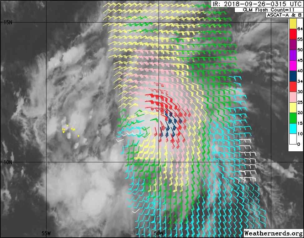
A little timeline... NHC uses ASCAT to upgrade the wave to KIRK. then 24 hours after ASCAT shows an open wave the NHC finally decides to downgrade. then for nearly 2 days relies solely on ASCAT(since the large amount of convection made it difficult to use sat) to determine it is still an open wave... now ASCAT shows a defined closed circ with stronger winds and larger structure than it has ever had but waits to upgrade?

waiting for another ASCAT ? when the first upgrade only took 1 ASCAT to be enough evidence... knowing shear will soon increase and ?? waiting for recon?? leaving the islands with less than 48 hours ( regardless if its a TS or a cat 5).

Well hopefully the 2am outlook will explain something..


As one of my guys just said ... this is "defeating the whole purpose of having the title 'Potential Tropical Cyclone' (PTC)" that the NHC came out with last year or was it the year before. Not to mention we are now under the 48 hours for Barbados at the least.
Last edited by brohavwx on Tue Sep 25, 2018 10:42 pm, edited 1 time in total.
4 likes   

djones65
Category 1
Category 1
Posts: 264
Age: 59
Joined: Mon Jun 20, 2005 12:05 am
Location: Ocean Springs, MS

Re: ATL: KIRK - Remnants - Discussion

#322 Postby djones65 » Tue Sep 25, 2018 10:41 pm

Warnings for the Lesser Antilles including Barbados are ALWAYS issued by the respective governments... The NHC ONLY advises or recommends warning issuance! So don't always blame the NHC if you believe a storm is under-warned...
As far as the remnants of Kirk... it appears sheared to me... and especially with the microwave image Aric presented earlier still indicated a partially exposed circulation center near 11.8N and 50.5W west northwest of the "blob" that is most likely the mid level circulation center.

Awaiting visible imagery or recon confirmation makes sense to me. In my humble opinion.
2 likes   

brohavwx
Tropical Depression
Tropical Depression
Posts: 74
Age: 63
Joined: Thu Jun 21, 2018 7:16 pm
Location: Barbados
Contact:

Re: ATL: KIRK - Remnants - Discussion

#323 Postby brohavwx » Tue Sep 25, 2018 11:02 pm

djones65 wrote:Warnings for the Lesser Antilles including Barbados are ALWAYS issued by the respective governments... The NHC ONLY advises or recommends warning issuance! So don't always blame the NHC if you believe a storm is under-warned...
As far as the remnants of Kirk... it appears sheared to me... and especially with the microwave image Aric presented earlier still indicated a partially exposed circulation center near 11.8N and 50.5W west northwest of the "blob" that is most likely the mid level circulation center.

Awaiting visible imagery or recon confirmation makes sense to me. In my humble opinion.


In all my years, our respective Govts tend to follow the NHC's lead and/or collaborate - as I said sometimes our own Met Service can act odd and out of touch with the public - however Barbados is also responsible for raising Watches and Warnings for St. Vincent & the Grenadines, St. Lucia and Dominica.

Barbados also has the main US Embassy & Consulate for the Eastern Caribbean here, so I would think there should be some mutual comms and overall responsibility.

Of course, like I suppose may happen elsewhere, when they raise a Watch or Warning and nothing happens the people cry false alarm - I usually shoot that down on my own forum/group if and when it raises its ugly (self-centered) head, as I prefer to err on the side of caution.

Also, I'm not sure where this 11.8 is coming from as I've had at 11.3 for the past few hours and only in the last hour or so has it nudged up closer to 11.5 and it continues to maintain what I consider a good CDO by comparison to the last few days. I will grant there is some sign of shear line push back from the west, so we'll have to see how it plays out over night I guess, regardless of whatever one may think.
2 likes   

User avatar
AubreyStorm
Category 1
Category 1
Posts: 337
Age: 44
Joined: Fri Jun 16, 2017 6:21 pm
Location: Texas, USA

Re: ATL: KIRK - Remnants - Discussion

#324 Postby AubreyStorm » Tue Sep 25, 2018 11:33 pm

Ohhhhh! Close call... Kirkkkkkkk

Image
0 likes   
The posts are NOT an official forecast. Please REFER to the NHC and NWS for official forecasts and products.

User avatar
AubreyStorm
Category 1
Category 1
Posts: 337
Age: 44
Joined: Fri Jun 16, 2017 6:21 pm
Location: Texas, USA

Re: ATL: KIRK - Remnants - Discussion

#325 Postby AubreyStorm » Tue Sep 25, 2018 11:39 pm

No doubt. Kirk is BACK to the GAME!

Image
1 likes   
The posts are NOT an official forecast. Please REFER to the NHC and NWS for official forecasts and products.

floridasun78
Category 5
Category 5
Posts: 3755
Joined: Sun May 17, 2009 10:16 pm
Location: miami fl

Re: ATL: KIRK - Remnants - Discussion

#326 Postby floridasun78 » Tue Sep 25, 2018 11:44 pm

last frame look get bit shear already maybe that why nhc not gone make it ts again
0 likes   

Aric Dunn
Category 5
Category 5
Posts: 21238
Age: 42
Joined: Sun Sep 19, 2004 9:58 pm
Location: Ready for the Chase.
Contact:

Re: ATL: KIRK - Remnants - Discussion

#327 Postby Aric Dunn » Tue Sep 25, 2018 11:44 pm

Assuming ASCAT is as useful as it was the last few days. I have been hesitant to place the center that deep into the convection. but if it is further under the deep convection per the recent data than KIRK may already be 50mph or more. washoping for a good microwave pass to see the structure. but none.
0 likes   
Note: If I make a post that is brief. Please refer back to previous posts for the analysis or reasoning. I do not re-write/qoute what my initial post said each time.
If there is nothing before... then just ask :)

Space & Atmospheric Physicist, Embry-Riddle Aeronautical University,
I believe the sky is falling...

Aric Dunn
Category 5
Category 5
Posts: 21238
Age: 42
Joined: Sun Sep 19, 2004 9:58 pm
Location: Ready for the Chase.
Contact:

Re: ATL: KIRK - Remnants - Discussion

#328 Postby Aric Dunn » Tue Sep 25, 2018 11:46 pm

floridasun78 wrote:last frame look get bit shear already maybe that why nhc not gone make it ts again


oh yeah there is for sure shear. though right now the outward force of the convection has been keeping the shear from reaching the core area.

it will eventually lose at some point. when is the question.
0 likes   
Note: If I make a post that is brief. Please refer back to previous posts for the analysis or reasoning. I do not re-write/qoute what my initial post said each time.
If there is nothing before... then just ask :)

Space & Atmospheric Physicist, Embry-Riddle Aeronautical University,
I believe the sky is falling...

Aric Dunn
Category 5
Category 5
Posts: 21238
Age: 42
Joined: Sun Sep 19, 2004 9:58 pm
Location: Ready for the Chase.
Contact:

Re: ATL: KIRK - Remnants - Discussion

#329 Postby Aric Dunn » Wed Sep 26, 2018 12:40 am

up to 90% .... they are just going to wait it out.

despite the evidence.
1 likes   
Note: If I make a post that is brief. Please refer back to previous posts for the analysis or reasoning. I do not re-write/qoute what my initial post said each time.
If there is nothing before... then just ask :)

Space & Atmospheric Physicist, Embry-Riddle Aeronautical University,
I believe the sky is falling...

User avatar
sgastorm
S2K Supporter
S2K Supporter
Posts: 66
Age: 57
Joined: Sat Aug 28, 2004 5:30 pm
Location: Valdosta, GA

Re: ATL: KIRK - Remnants - Discussion

#330 Postby sgastorm » Wed Sep 26, 2018 12:51 am

Aric Dunn wrote:up to 90% .... they are just going to wait it out.

despite the evidence.


2. Thunderstorm activity has increased and become better organized in
association with the remnants of Kirk located about 650 miles east
of the Windward Islands. Recent satellite-derived wind data also
indicate that the circulation has become better defined and that the
winds have increased. If this development trend continues, then
advisories will be re-initiated on this system later this morning.
Interests in the Windward and Leeward Islands should monitor the
progress of this disturbance. An Air Force Reserve reconnaissance
aircraft is schedule to investigate this disturbance later today.
For more information on this system, see High Seas Forecasts issued
by the National Weather Service.
* Formation chance through 48 hours...high...90 percent.
* Formation chance through 5 days...high...90 percent.

Sounds like they may start advisories soon. I wouldn't be completely surprised if the NHC does so at 5 am.
0 likes   

User avatar
Hammy
Category 5
Category 5
Posts: 5849
Age: 41
Joined: Fri May 25, 2012 5:25 pm
Contact:

Re: ATL: KIRK - Remnants - Discussion

#331 Postby Hammy » Wed Sep 26, 2018 12:53 am

Aric Dunn wrote:up to 90% .... they are just going to wait it out.

despite the evidence.


I've never seen advisories initiated outside of the standard package times unless there was an ongoing recon mission. And we had the telltale "if this trend continues" line which usually simply means "unless convection suddenly implodes"
0 likes   
The above post is not official and should not be used as such. It is the opinion of the poster and may or may not be backed by sound meteorological data. It is not endorsed by any professional institution or storm2k.org. For official information, please refer to the NHC and NWS products.

Aric Dunn
Category 5
Category 5
Posts: 21238
Age: 42
Joined: Sun Sep 19, 2004 9:58 pm
Location: Ready for the Chase.
Contact:

Re: ATL: KIRK - Remnants - Discussion

#332 Postby Aric Dunn » Wed Sep 26, 2018 12:55 am

Hammy wrote:
Aric Dunn wrote:up to 90% .... they are just going to wait it out.

despite the evidence.


I've never seen advisories initiated outside of the standard package times unless there was an ongoing recon mission. And we had the telltale "if this trend continues" line which usually simply means "unless convection suddenly implodes"


all the evidence came before the 11pm time..

they will wait till recon.

on top of that IF THE convection maintains. Recon will likely find a 60 mph TS..
0 likes   
Note: If I make a post that is brief. Please refer back to previous posts for the analysis or reasoning. I do not re-write/qoute what my initial post said each time.
If there is nothing before... then just ask :)

Space & Atmospheric Physicist, Embry-Riddle Aeronautical University,
I believe the sky is falling...

User avatar
chaser1
S2K Supporter
S2K Supporter
Posts: 5464
Age: 64
Joined: Sat Oct 15, 2005 5:59 pm
Location: Longwood, Fl

Re: ATL: KIRK - Remnants - Discussion

#333 Postby chaser1 » Wed Sep 26, 2018 1:46 am

You all can make your own judgement regarding "Kirk The Wave" but I'm pretty sure I'm looking at a warm spot (potential developing eye signature). Time will tell if it's a "sucker-hole" or other transient feature.

Image
1 likes   
Andy D

(For official information, please refer to the NHC and NWS products.)

User avatar
meriland29
Category 2
Category 2
Posts: 770
Joined: Thu Aug 03, 2017 11:05 am

Re: ATL: KIRK - Remnants - Discussion

#334 Postby meriland29 » Wed Sep 26, 2018 2:08 am

on IR he looks like he is weakening last few frames ??
0 likes   

User avatar
chaser1
S2K Supporter
S2K Supporter
Posts: 5464
Age: 64
Joined: Sat Oct 15, 2005 5:59 pm
Location: Longwood, Fl

Re: ATL: KIRK - Remnants - Discussion

#335 Postby chaser1 » Wed Sep 26, 2018 2:36 am

meriland29 wrote:on IR he looks like he is weakening last few frames ??


Just my take on it but i'd guess is it's weakened to a 50 mph Tropical Storm lol. Kidding aside, you rightly are noticing how some mid to upper level winds (below the 200 mb level) or an entrainment of dryer air is appearing to penetrate possibly eroding the western quadrant and close to the CDO. Time will tell whether additional convection can/will temporarily fight off those encroaching hostile conditions
1 likes   
Andy D

(For official information, please refer to the NHC and NWS products.)

User avatar
Hammy
Category 5
Category 5
Posts: 5849
Age: 41
Joined: Fri May 25, 2012 5:25 pm
Contact:

Re: ATL: KIRK - Remnants - Discussion

#336 Postby Hammy » Wed Sep 26, 2018 3:15 am

Aric Dunn wrote:
Hammy wrote:
Aric Dunn wrote:up to 90% .... they are just going to wait it out.

despite the evidence.


I've never seen advisories initiated outside of the standard package times unless there was an ongoing recon mission. And we had the telltale "if this trend continues" line which usually simply means "unless convection suddenly implodes"


all the evidence came before the 11pm time..

they will wait till recon.

on top of that IF THE convection maintains. Recon will likely find a 60 mph TS..


Back to a TS as per latest BT as expected. "If current trends continue" always means upgrade on next advisory :P
2 likes   
The above post is not official and should not be used as such. It is the opinion of the poster and may or may not be backed by sound meteorological data. It is not endorsed by any professional institution or storm2k.org. For official information, please refer to the NHC and NWS products.

User avatar
northjaxpro
S2K Supporter
S2K Supporter
Posts: 8900
Joined: Mon Sep 27, 2010 11:21 am
Location: Jacksonville, FL

Re: ATL: KIRK - Tropical Storm - Discussion

#337 Postby northjaxpro » Wed Sep 26, 2018 3:58 am

Kirk is back!!
Last edited by northjaxpro on Wed Sep 26, 2018 5:26 am, edited 2 times in total.
1 likes   
NEVER, EVER SAY NEVER in the tropics and weather in general, and most importantly, with life itself!!

________________________________________________________________________________________

Fay 2008 Beryl 2012 Debby 2012 Colin 2016 Hermine 2016 Julia 2016 Matthew 2016 Irma 2017 Dorian 2019

User avatar
Nimbus
Category 5
Category 5
Posts: 5300
Joined: Mon Jul 19, 2004 10:54 am

Re: ATL: KIRK - Tropical Storm - Discussion

#338 Postby Nimbus » Wed Sep 26, 2018 4:45 am

They have a potential recon mission headed for 12.5N 56.0W which would bring either the wave apex or center of Kirk over Martinique with Dominica and possibly as far north as Guadeloupe additionally needing tropical storm preps. Extra line on the boat mooring, extra brick on the blue tarp, take in the lawn furniture etc. So I guess its just the cost of a mission at stake at this point.
0 likes   

User avatar
northjaxpro
S2K Supporter
S2K Supporter
Posts: 8900
Joined: Mon Sep 27, 2010 11:21 am
Location: Jacksonville, FL

Re: ATL: KIRK - Tropical Storm - Discussion

#339 Postby northjaxpro » Wed Sep 26, 2018 5:39 am

Kirk is a fighter no doubt!
He has been battling against the odds fighting shear. his entire lifespan. He has put up an admirable defense to this juncture.
However, looking in the short term, the Caribbean shredder, the screaming shear machine, will in all likelihood, cause Kirk to finally give up the ghost by the end of this week!
0 likes   
NEVER, EVER SAY NEVER in the tropics and weather in general, and most importantly, with life itself!!

________________________________________________________________________________________

Fay 2008 Beryl 2012 Debby 2012 Colin 2016 Hermine 2016 Julia 2016 Matthew 2016 Irma 2017 Dorian 2019

User avatar
NDG
S2K Supporter
S2K Supporter
Posts: 15446
Joined: Sun Jul 09, 2006 10:14 pm
Location: Orlando, FL

Re: ATL: KIRK - Tropical Storm - Discussion

#340 Postby NDG » Wed Sep 26, 2018 5:41 am

Notice that the NHC said that the shear is forecasted to decrease to less than 10 knots over the next 24 hours or so, the ECMWF was not crazy as many said yesterday. At least a strong TS by tomorrow morning before it starts getting hit by the shear tomorrow is not out of the question. IMO.

Image
1 likes   


Return to “2018”

Who is online

Users browsing this forum: No registered users and 0 guests